This is the third part of my personal journal about Intergeo 2025. I entered the halls on the last day, 9 October 2025, with several booths still to visit. Charly Lothhammer, senior technical consultant on the Vexcel Imaging booth, explained that the company was deploying new lenses in order to deliver more light to the tiny pixels of the Sony IMX811 chips. The models with this are now branded as “4.2” and “5.0”. Vexcel Imaging was delighted that it had made the first sale of its UltlraCam Dragon 4.2 hybrid system to Netherlands company Slagboom & Peeters. Also featuring the IMX811 was the UltraCam Merlin 5.0, announced at Intergeo, with a 37,500 x 19,000 pixels footprint. Interchangeable lenses are now available with Merlin. Its Bayer array technology has enabled Vexcel Imaging to compete at a lower price point, but there are some customers who prefer pan-sharpening for the nadir images and for them the UltraCam Eagle 4.1 is the answer.

INTERGEO 2025 winds to a close in Frankfurt.
RIEGL, as always, did not disappoint. My visit was hosted by Susan Licari and Abby Clark, vice president and marketing manager respectively at RIEGL USA. My tour guides were My-Linh Truong Martin and Michael Sitar, also RIEGL USA, where they fill the division manager unmanned laser scanning and airborne division manager roles respectively. In the background, Austrian lidar luminaries Dr. Johannes Riegl, the company’s founder, and technical wizard Dr. Martin Pfennigbauer, CRO and co-CTO, were keeping a watchful eye.
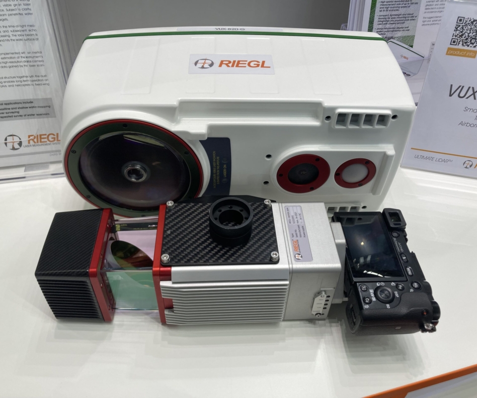
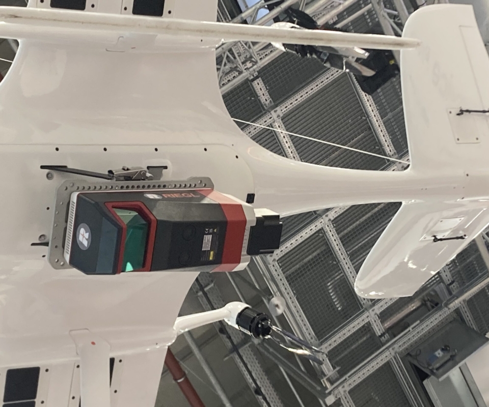
Truong Martin started by showing me the brand new RIEGL VUX-820-G, a compact topobathymetric lidar sensor, substantially smaller and lighter than VQ-840-G and VQ-860-G. At 5.7 kg, about half the weight of the VQ-840-G, it is suitable for larger UAVs and, of course, helicopters. An example was hung high in the booth, mounted on a UAV from the Netherlands company Acecore. The performance is a little less than the VQ-840-G and VG-860-G, but it still boasts 100 kHz PRR and 2.2 Secchi depths. The VUX-820-G has a bright green status light that can be seen from afar to indicate that all is well and a touchscreen panel at one end. Like many members of the VUX family, the VUX-820-G has the RiLOC-F-inside GNSS/IMU solution.
She also showed me several other members of the expansive model range for UAVs. The year superscripts that have been added at the ends of some of the model numbers are indeed a blessing! One of the major enhancements, however, has been the integration of RIEGL sensors on to the new DJI M400 Matrice UAV, which has made a significant impact with its 6 kg payload and 59-minute endurance. In the same vein, RIEGL has trimmed 100 grams off the weight of the VUX-100, enabling it to fly on the DJI M350. The products are more compact too, with the RiLOC-F-inside fitting inside the housing of the VUX-160 and higher models. For customers who prefer a Trimble Applanix solution, RIEGL can supply this too.

Demonstration at Phase One.
Sitar took over and we started amongst the big sensors. The VQ-1560-III S, VQ-1460, VQ-1260 and VQ-1060 were displayed close to each other – a striking sight. The VQ-1060 is new, designed for corridor mapping, with fore and aft oblique RGB cameras and nadir RGB and NIR cameras alongside the very capable lidar. Corridor requirements, such as electricity transmission and distribution, are inherently multisensor. RIEGL’s pod-based solutions for helicopters have, of course, supported this market, but the company felt there was a shortfall on the airborne side and has now introduced a big sensor to match the requirements. Corridors contain expensive infrastructure, so the generation of geospatial data products along them is often more profitable than broad-area mapping. Sitar went into considerable depth explaining the technology behind and the advantages of the scan patterns and point densities that RIEGL airborne lidar solutions offer. He showed me the same diagram that I had seen on the Vexcel Imaging booth. The requirements can be met with a less powerful laser than is used in, for example, the VQ-1560-III S: it’s the mid-altitude, multi-directional unit from the VQ-680, which is also used in the Vexcel UltraCam Dragon 4.2. Indeed, Sitar likened the VQ-1060 to “a Dragon minus the side obliques”, while admitting that the latter is a photo-centric solution for urban mapping, whereas the former is lidar-centric for corridors.
The first system has already been delivered to a US utility, with which Sitar had worked on the specifications. This may mark the beginning of a big change, i.e. utilities taking inspection work in-house with their own aircraft rather than contracting out the data acquisition to a geospatial services company. These organizations often fly helicopters already, but aircraft less so. It’s also possible that utilities flying certain sensors will want their geospatial sub-contractors to fly the same ones. We will see!

We moved on to the VQ-1560-III S and talked about the dual lasers and cross-fire scan patterns. I pointed out that Sitar had a lot to say about scan patterns. He agreed that optimizing scan geometry for specific applications had been a focus for RIEGL over the years, though Sitar acknowledged that competitors were moving in this direction too. Indeed, customers in some countries seem to prefer one scan pattern, while those in a different country prefer another – and the suppliers must respond. Sitar added that various upgrade paths are available within the range.
We were short of time now, so Sitar gave me just a glimpse of the other three new products launched at Intergeo. We quickly visited the VMX-3HA Mobile Mapping System, the latest in a line of high-performance systems for vehicle mounting, producing denser data than its predecessors through its VUX-3HA laser scanners.
Next was the VLS-1200i terrestrial laser scanner, with longer range than before, up to 1800 m, not only so that setups can be further apart but also to meet specific project requirements, and with both static mode for tripod mounting and kinematic mode for vehicular use, as well as high speed – 30 seconds for a 6 mm x 6 mm scan. We looked briefly at the VZ-6000i-26, the latest long-range TLS model with up to 6 km reach, optimized for snow and ice applications.
We went down memory lane. Sitar thought that the RIEGL VZ product line had been predated by Optech’s ILRIS, which was the first such system to use intensity. This feature in turn migrated to the airborne systems such as the ALTM 1210. A long time ago!
We agreed that RIEGL is prolific in terms of new product introductions. All the RIEGL folk were so product fluent, patient and eager to answer my questions. I hope I did them justice by absorbing their information and continuing to master the massive RIEGL product range.
My second Trimble interviewee was Arnaud Lezennec, senior applications engineer, based in a Trimble office near Nantes in France. After an MS in geology from the National Museum of Natural History in Paris he was employed briefly as a geologist. In early 1997, he had been working on his (unfinished) PhD and was an expert on caves, when he was approached by people from Mensi, who entranced him what their scanner could do with caves and castles. Lezennec “fell in love with point clouds.” He joined Mensi in April 1997 – his first project was in a Swedish nuclear facility – and entered Trimble via the 2003 acquisition. This interview was delightful. Lezennec is engagingly happy and content. He has expertise in multiple Trimble hardware and software geospatial products and relishes his life helping customers and refining best practices. He remains energetically motivated after 28 years with Trimble. He reiterated a topic I had discussed the previous day with Boris Skopljak – the products provide knowledge for the surveyor as he is going into the field – “bring the design into the field”. His passion is “field-to finish” and he feels that, through closeness to customers and distributors, he is “walking the talk.” He is conscious, too, of the need for us geospatial people to share information with people from outside our world, for example local government officials.
A Trimble representative fields questions.
I mentioned the combination of MMS and ground-penetrating radar featured in a recent article in LIDAR Magazine and Lezennec was very familiar with these use cases. Indeed, he had been able to deliver substantial productivity increases to several users of manual GPR systems by connecting them to Trimble GNSS receivers and TerraFlex software.
We talked about democratization of reality capture. Lezennec echoed what I had heard from others – it’s easy to collect data, but skill is needed to ensure that the results are satisfactory. You have to collect the right data!
Lezennec waxed lyrical on the Trimble SX12, a high-performance, robotic total station that incorporates a laser scanner. The two technologies are indeed one and the same. He stressed the value of images as well as the measurements, not only to provide more information but also for QA/QC and a check on completeness.
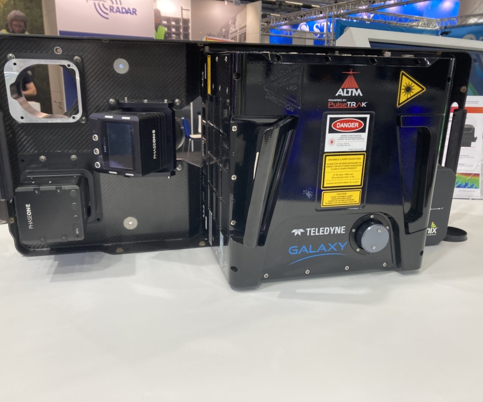
The elegant Teledyne Geospatial booth was inexplicably quiet, so senior product manager Malek Singer was able to give me a leisurely tour. Not only was the company showcasing its renowned lidar hardware, it also highlighted the seamless integration with industry-leading software workflows. The emphases were miniaturization and real-time, on-board processing. He reiterated what others had told me about increasing demand for fast data production, for example for disaster management. Data volumes are too great for transmitting during flight, but when the aircraft lands the storage media can be unplugged with the point cloud ready for transfer to the cloud, analytics software, etc. There’s a powerful logic to this use of valuable time. The solution is Network Surveyor, powered by Galaxy Edge, which combines the renowned Galaxy sensor with real-time, onboard processing and is designed to meet the time constraints of electric utilities, featuring real-time processing and an advanced software analytics stack for utility operators. Galaxy itself benefited from major improvements to scan pattern and noise reduction in 2024 and, indeed, has been continually enhanced during its ten-year lifespan.
Teledyne Optech is about to begin fielding the EchoONE, the company’s smallest lidar sensor to date, at just 1.65 kg, combining long-range performance with NDAA-compliance and real-time generation of fully georeferenced, undecimated point clouds. Although experience gained on the previous CL sensor has been valuable, EchoONE is fundamentally a new development fashioned around the goal of miniaturization.
Another component of project speed, of course, is rapid deployment, so Teledyne Optech has developed Stratus – a lightweight (<10 kg), pod solution for quick fitting to aircraft or helicopters. Malek explained that the differentiator was not so much the topographic lidar, but the real-time processing, where special advantages accrued from the company’s close relationship (geographical, scientific and commercial) with Trimble Applanix. These solutions have extra appeal in parts of the world where specialist survey aircraft are not readily available. But inside is the faithful, high-end Teledyne Optech lidar. Stratus can be configured in different ways with multiple Echo lidar sensors and cameras. And it’s FAA-compliant.

Visitors to the “Application Dome” enjoyed various technical tours.
We moved to Fathom, a topobathymetric airborne lidar system. Teledyne Optech has been famous for decades for its industry-leading bathymetric lidar solutions, SHOALS and CZMIL, but more recently customer feedback has indicated increasing demand for bathymetric lidar, but with lighter, more compact solutions so that mobilization costs are more manageable. The solution was to trim 100 kg off CZMIL and fit it into a cube that could be deployed in a standard aircraft hatch and gyrostabilized mount. The system also contains topographic lidar and cameras, so the user is not constrained to bathymetry only. To my surprise, Malek said that feedback indicated that density is more important than depth, with great interest in the 0-20 m range rather than deeper. Thus the pulse rate has been increased, with the goal of identifying smaller objects underwater. The product is being thoroughly tested against Canadian Hydrographic Service data for the Great Lakes.
Malek seemed happy to be working for a company that boasts a magnificent legacy yet remains the originator significant improvements and innovations. He is following the footsteps of his predecessor, Michael Sitar, with deftness and imagination. He noticed that, although the established companies continue to innovate, there were new players in the hall. His take on the state of the industry was succinct: “We’re no longer in a world where a geomatics engineer builds for a geomatics engineer. Now, the user of the data is someone with different qualifications. The person who touches the sensor in the plane used to be a hydrographer, and now the job requirements for sensor operators have nothing to do with hydrography – youth, ability to travel, some computer knowledge, eagerness. And we need to design for these people.”
Malek had me so absorbed in the details of the airborne lidar products that I completely forgot to ask him whether he was looking forward to the CZMIL SuperNova slogging it out in the marketplace against Leica CoastalMapper!
A last walk round the floor had mixed results. I couldn’t see people I wanted to talk to on the CHCNav, DJI, IGI and Phase One booths, but, as I do every year, I spent a few minutes looking at the historical display of the evolution of the Geodätentag from its beginnings in 1872 to the transformation into Intergeo in 1995, and the rapid growth in size and global reach thereafter.
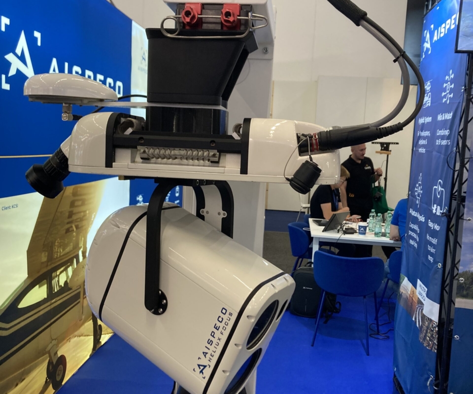
I happened upon a Lithuanian company, AISPECO, which manufactures pods for fitting to helicopters and aircraft and distributes them worldwide from its Vilnius headquarters. Simonas Krasauskas, VP of product development, described one use case: a pod is deployed in Antarctica by one of the Australian mapping agencies. How I would love a podcast with connections to Lithuania and Antarctica at the same time.

Demonstration of the Trimble® X9 3D laser scanning platform.
It was 5 pm, an hour before show closure, when Cas Heuvelmans sat me down with my third Trimble interlocutor, Steven Woolven, president of Applanix Corporation. As we began, staff were removing bottled water, glasses, stools and other items, leaving us with three stools and a table in an empty booth, all of us nonplussed!
I put on my ISPRS hat for a moment. Trimble will be exhibiting at the XXV ISPRS Congress in Toronto in July 2026 and there will be tours of the Trimble Applanix facility. I thanked Woolven for Trimble’s co-sponsorship (with Elsevier) of the Fritz Ackermann Award, which will be presented in Toronto for the first time, as I had thanked Skopljak the previous day.
To save time, we quickly moved to the new products Trimble Applanix had just announced, firstly PosPac Complete, then two new positioning system portfolios for mobile mapping and direct georeferencing — Applanix POS LVX+ and Applanix POS AVX RTX. Woolven was pleased with these launches and explained that they are underlaid by a new business model. They are subscription-based, POSPac in its entirety, the others involving some hardware that the subscriber pays for upfront and keeps. The subscriptions come at different price points. The products are also easier to use, though the full flexibility is there for power users. The product and the pricepoint can be tailored to user requirements. Changes can be made on a three-month basis, so it is reasonable to change the subscription from one big project to another. Customers like subscriptions, thought there were doubts at the beginning. Woolven pointed out that not all customers can operate in the cloud. The new systems are available for both airborne and land products, though POSPac is also used by marine customers.
The race to level 5, full driving automation.
I tried to broaden the discussion by asking Woolven in what respects he felt Trimble Applanix leads the market. His answer was perfectly worded: “I think what we do well is bring the hardware, the processing capability, the ecosystem. One of the trends we’ve seen over the last few years is that our customers want to do their job. They want to collect data. They want to deliver the information to the end user. They don’t want to mess around with the technology, getting bits and bytes to work and this software to work with that software. So we’re getting more pressure from customers who say, ‘I want you to deliver me a fully functioning ecosystem where the whole thing works. I can do my job. I can do it quickly, efficiently, cost effectively, and deliver to my end customer quickly.’ Whereas, going back a little bit, some markets were far more wild west, and I think to a large extent, even in the UAV space, we’re seeing that go away. Companies are more focused on delivering value to their customer.”
While technology and accuracy rise, Woolven feels that Trimble’s emphasis on data quality is key. Trimble Applanix has invested heavily to ensure that the customer knows about a problem as soon as possible. He agreed with the parallels I used with the new Trimble data tablets helping the field surveyor to avoid mistakes. Re-work is always expensive, but especially so if an aircraft or a marine survey vessel is involved.
The acquisition by Trimble has been a huge success, enabling Applanix to access, for example, GNSS receivers, large-scale manufacturing and a global marketing apparatus. Furthermore, the Applanix group benefits from the strengths that Trimble is currently proselytizing, such as the Trimble Business Center software stack (PosPac is now completely embedded in TBC), Trimble Connect, the emphasis on the cloud, and the focus on subscription products. POSPac, therefore, is used in the processing of data from the MX series. Woolven was especially pleased, however, with the Trimble distribution channels and the markets to which they give access. As a result, the products have penetrated many more segments than they would have done if Trimble had merely been a customer of Applanix Corporation. Of course, Trimble Applanix makes full use of Trimble GNSS technology, but things work the other way round too, as Trimble Applanix research with IMUs goes back into other parts of Trimble, such as the MX series.

Various OEM boards on display.
Woolven felt that Trimble has improved over the years at de-siloing itself. By the time Steve Berglund [former CEO] left, it had completed around 150 acquisitions. There’s been a concerted effort under Rob Painter [current CEO] to do what the customers want Trimble to do – connect and scale.
To finish, I asked Woolven about AISPECO (see above). He described the companies’ OEM relationship, which had been in place for some time. This segued into another interesting aspect of the Trimble Applanix business. Woolven’s colleague Joe Hutton had foreseen the OEM opportunities in the airborne market more than 15 years ago and was a strong proponent. He wanted Trimble Applanix to build on its tremendous success with standalone products. It had to master this business model or be left behind. And he was right, Woolven acknowledged enthusiastically. Hence the company has been relentless at pushing its technology into OEMs. As Woolven put it, “When you walk around this show, but going back to the last show or the show before, when there were just so many UAVs, maybe every second booth, it was fun to walk around, because 90% of those UAVs, even if you didn’t know it, had our stuff inside!”
Woolven had noticed other interesting newcomers in the halls. How long before they too had Trimble Applanix inside? We concluded, as such conversations so often do, complimenting the wonderful technology and amazing people in the geospatial world. Woolven was adamant that the people are phenomenal to work with. And there were many new faces coming into existing businesses. He felt that the geospatial industry is becoming increasingly fascinating and having impact. We’ve known for a long time the influence that geospatial data can have on hurricane or earthquakes management and the help it can bring people in really difficult situations. More people are recognizing that power and are finding the geospatial industry a fine place to work.
The last day of Intergeo usually brings a torrent of reflections, speculations and ideas. Firms have invested heavily in exhibiting, yet booth staff begin dismantling displays up to three hours before the show closes. It’s depressing to watch this and realize that that’s it over for another year. I dawdled in the increasingly deserted halls until the 6 pm closing.
Final thoughts
For LIDAR Magazine readers working on the airborne side, this was a red-letter Intergeo, with significant innovations from Hexagon, RIEGL, Teledyne Geospatial, Vexcel Imaging and others. Some trends are clear. The Sony IMX811 chip is becoming ubiquitous and the adopters are striving to squeeze the best performance out of the tiny pixels. Single-photon lidar and Geiger-mode are alive and well, albeit mainly for special, broad-area applications, with the Hexagon SPL and Woolpert Zeus innovations hitting the headlines. We take improvements in accuracy, MHz, ppsm and ROI for granted: the suppliers are working hard on FoV (for both imagery and lidar – ideally they should be very similar) and scan patterns. Thus a particular lidar sensor may be chosen for a particular task, such as corridor mapping. Above all, there’s more stress on faster deployment on a greater variety of platforms, in order to generate faster results, for example for disaster management and first response, hence the focus on helicopter and wing-strut mounting and on pods, the Hexagon MultiMapper leading the way. Furthermore, some sensors may be developed to suit particular UAVs. Less critically, perhaps, all the sensors looked great: Hexagon, IGI, ITRES, Phase One, RIEGL, Teledyne Geospatial, Vexcel Imaging, all a credit to our industry. The number of players in the photogrammetry and lidar space continues to mushroom, for example DJI offers hardware and software for an end-to-end workflow, whereas Esri adds deeper functionality on the processing side. The geospatial services companies, naturally, are quick to take advantage as they optimize their hardware and software investments to be yet more competitive.
Overall, there were very positive messages, for example from the press conference. “We have the technology” and it’s improving all the time, taking ROI with it. In a world of increasing, worrisome uncertainty, remarkable optimism prevails. AI is proving both pervasive and useful. Distributed and cloud processing are the norm. An abundance of data is easy to obtain, an abundance of caution in using it well advised. We need numerous talented, well-trained humans to keep an eye on all this – with a different skillset from today.

Next year, INTERGEO will be held at Messe München, 15-17 September 2026.
We reported last year on the change of professional conference organizer for Intergeo, from Hinte to Frankfurt Messe, which becomes effective in 2028. Under the Hinte banner, however, Intergeo will move to Munich in 2026, then back to Frankfurt in 2027, when the Hessian city will become the show’s permanent home.
For those of us involved in airborne lidar, this was a riveting Intergeo. The event had slightly fewer exhibitors than in recent years, but there were myriad products worth a look. The advice remains the same: to avoid being overwhelmed or feeling inadequate, make plans beforehand, of people to meet, booths to visit and presentations to attend, to say nothing of fringe events. Remember to try everything: don’t spend all the time on the show floor, but go to the theaters and the conference too. In the geospatial world, only the Esri International User Conference in San Diego competes with Intergeo in size, but its GIS focus is far narrower. Put Messe München, 15-17 September 2026 in your diary now!
Acknowledgements
I’ve been working on LIDAR Magazine for eight years now and it’s worth repeating that all the people with whom I interacted before, during and after Intergeo, in marketing, on the technology side, or in management, were unfailingly welcoming and helpful. These are the connections, many of them enduring for many years, that make the geospatial world so worthwhile. The magazine is proud to be part of this community. I include, moreover, not just the companies exhibiting at Intergeo, but the PR companies that they rely on to get their messages out, for example Keaton Public Relations and TFD. Last but not least, I would be remiss if I didn’t acknowledge the marvelous effort and hospitality of the HINTE expo and conference team, in addition to their long-time, exceptionally talented show photographer, Nico Herzog, for the majority of the images utilized herein.
###
Editor’s note: This is the third of a three-part retrospective. Access part I here or part II here.