The ASPRS 2021 Annual Conference was conducted on Zoom from 29 March to 2 April. This sounds like an endurance test, with sessions from 7 am to 3 or 4 pm Pacific time on all five days, but the program was comprehensive, with informative abstracts, so that it was easily possible to choose when to join.
And many did! The event drew well over 300 participants, of whom an average of 89 were logged on at any one time. There were four sponsors. As we move through the pandemic, our behaviors in the age of online conferences are intriguing. Although the “average attendance”, in the sense of total Zoom time divided by number of participants, was 11 hours, there were numerous attendees in the tails – many joining for just one session and many others soaking up most of the week!
The core of the program consisted of 21 sessions in which 97 papers were presented in 15-minute slots, many of them replete with lidar content. Usually there was time for a question or two. The presentations were pre-recorded, with a length specification of 13 minutes, and I much preferred the recordings where there was a tiny view of the author superimposed on one corner of the PowerPoint. There were three panel discussions. The first was key to the US lidar community – a USGS session, with eight presenters, entitled “The 3D National Topography Model: next-generation of 3DEP and NHD”. The second and third focused on AmericaView and its work with satellite imagery.
In addition, there was a session with eight “Ignite-style talks”: the pre-recordings were five minutes and there was a common Q&A session. How we struggle to find names for alternative formats to make the program more interesting and give opportunities to more researchers to show what they have been doing! I remember having a conversation in 1999 with the late Klaas Jan Beek, congress director of the ISPRS Congress in Amsterdam in 2000. Klaas was trying to persuade me, in my role as marketing director of LH Systems, to spend a lot of money on the Congress (we did!) and he kept on talking about “crosscutting sessions”. To me, a crosscut was a type of saw used in carpentry, so I was bemused, though his enthusiasm was captivating. ASPRS further diversified its program with a session of 12 posters. The authors were given two minutes each to present, then there was a general Q&A session. Before the session, however, the posters were displayed in an absolutely first-class gallery, in which the view transitioned from one to the next to the next, but it was possible to click on a poster, at which point the merry-go-round stopped and an enlarged view of the chosen morsel appeared – magic!
Bad Elf, TopoDOT, GeoCue and Bayesmap Solutions invested in “vendor spotlight” slots, in which they had 30 minutes to present their wares. All four presenters were beautifully prepared, with measured, informative presentations mercifully short of effusive sales pitches. These were superb – congratulations to all.
The Society’s many annual awards were presented, in short bursts throughout the week. Virginia Norwood, “Mother of Landsat”, won the Lifetime Achievement Award and gave live remarks – what a privilege to hear her! Steve Coast, founder of OpenStreetMap, was presented with the Outstanding Technical Achievement Award. Henry (Hank) Theiss, sensor modeler par excellence now with the University of Arkansas, won the Fairchild Photogrammetric Award, 15 years after the recipient had been my professor and mentor, Gordon Petrie, whose obituary I wrote for these pages not so long ago. And terrestrial laser scanning guru Adam Spring was flabbergasted to receive not just the Grand Award, but also first Honorable Mention for the Talbert Abrams Award, which encourages the authorship and recording of current, historical, engineering, and scientific developments in photogrammetry. I could wax lyrical about the wonderful winners of all the awards, but you can find the details on the ASPRS website.
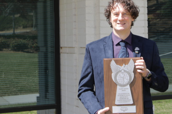
Dr. Adam Spring with the Talbert Abrams Award, for his two-part history of laser scanning, published in Photogrammetric Engineering & Remote Sensing in July and August 2020. The photo is taken in front of the former US headquarters, in Norcross, Georgia, of Mensi, which was acquired by Trimble in 2003. Mensi is described in Adam’s articles.
The last session on Wednesday was the ASPRS annual business meeting, presentation of numerous awards, and installation of officers. Jason Stoker of USGS took over as president from Jeff Lovin of Woolpert, perhaps the Society’s first “virtual president”, who ended a strong year at the helm. And in the same slot the following day ASPRS mounted a “Meet the Emeriti” session, in which a group of the Society’s many renowned emeritus members talked about themselves and, in particular, how they came to follow careers in photogrammetry. I found this fascinating – we all have our stories and they’re more complicated than, “After some years wanting to be a fireman, I decided at the age of twelve to become a photogrammetrist”. We are all the beneficiaries of these emeriti choosing photogrammetry over the many other professions in which they would doubtless have starred. It was especially gratifying to see John Trinder and Clive Fraser participating from Sydney and Melbourne respectively. Indeed, John gave the third last presentation of the conference. The title of his paper was “Remote sensing for ecosystem services and urban sustainability” and reflected John’s growing concern with sustainability, global warming and related phenomena. John confided, “I have a feeling that the earth is going to be very uncomfortable in the future unless huge changes are made to human activities. I won’t be around to experience it, but I feel I must take some actions that may alleviate the discomfort somewhat in the future.” These are the frank views, based on his latest research, of a veteran photogrammetrist with decades of service to the University of New South Wales and to ISPRS. We should listen.
Thus it was a wonderful conference. My work begins now, however, to approach presenters of lidar topics to determine whether any have interest in publishing in the magazine. The proceedings of the conference will be published, according to the practice, in the ISPRS Archives. Most of the work will lead to further publications in peer-reviewed periodicals, but sometimes the nature of the topic, or the audience that the researcher seeks to reach, demand a different outlet and that’s where LIDAR Magazine comes in. For example, we certainly want a follow-up after the presentation by Jennifer Aitken of the new Teledyne Optech CZMIL SuperNova topobathymetric sensor. Watch this space!
It’s tempting, of course, to draw a comparison with the ISPRS event conducted last year. Both had the feeling, to some extent, of being conveyor belts for students and early-career researchers to present their work – but that’s what professional societies do. ISPRS opted for parallel sessions, ASPRS for a single track. ISPRS had eminent professors chairing sessions, ASPRS didn’t. ASPRS had registration fees, ISPRS didn’t. Both approaches worked and both events were enjoyable. The important point is that, despite covid, the development of photogrammetry, remote sensing and GIS flourished and the results were made available to the profession in an easily accessible way. Next year, we hope that Geo Week goes ahead and that the ASPRS 2022 Annual Conference is co-located in Denver in February with ILMF, AEC Next, SPAR 3D and USIBD. Nevertheless, ASPRS will probably hold another virtual event later in 2022, enabling researchers whose funds preclude attendance in Denver to participate economically. This is progress for all.