
Jeff Lovin, Woolpert senior vice president, was sworn in as president of ASPRS on March 25, 2020. Lovin likely will serve out his entire term virtually due to the worldwide COVID-19 pandemic.
Woolpert Senior Vice President Jeff Lovin has served as president of the American Society for Photogrammetry and Remote Sensing (ASPRS) since March 2020. In this Q&A, the industry veteran shares what it was like leading the organization virtually, what technologies are shaping the industry and what geospatial trends to watch as 2021 moves forward.
To set the stage for 2020 and beyond, what were some of the more notable advances in lidar, photogrammetry and remote sensing in recent years?
The biggest advancement in the last few years has been the huge leap forward in linear-mode lidar capability. The emergence of Geiger-mode (GM) and single-photon lidar (SPL) a couple of years ago created a huge buzz, generating excitement but also sparking some panic about what the introduction of these new lidar methods meant for the industry. In the end, GM and SPL didn’t change the market as projected, but they did spur manufacturers to further develop traditional linear-mode lidar systems.
As a result, we now have the best, most advanced and efficient lidar systems. We are seeing sensors that are about three times as efficient as the former models, collecting lidar at higher altitudes and gaining a wider swath of data per flight. We would not be where we are today if it weren’t for the commercialization of GM and SPL, which seem to be finding their niche in markets like energy.
The other notable advancement would have to be the industry’s integration of deep learning and cloud solutions, which I didn’t anticipate coming so fast into our world. The emergence of artificial intelligence, machine learning and deep learning into the photogrammetry and remote sensing marketplace has quickly become integral to our operations, effectively replacing traditional processes.
2020 was a difficult year for just about everyone. What challenges did 2020 present specific to the industry?
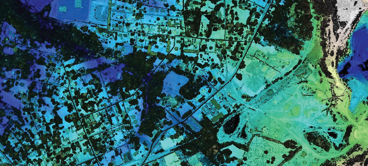
Lovin said one of the biggest advances in the last few years has been the huge leap forward in linear-mode lidar capability. Image courtesy of USGS
Working remotely, like so many around the world, was a challenge for the industry. We produce, process and manage big data and huge datasets daily. The industry has a technical workforce that had never worked from home—never even tried it. We dealt with the challenges of local broadband issues and developed protocols to keep projects running.
The second far-reaching challenge was the impact the pandemic had on our clients, government budgets and the market itself… and we haven’t felt the full effect of that yet.
Third would be its impact on conferences and tradeshows. We have gone nearly nine months now since the last in-person conference and most of us have attended several virtual conferences. We learned how to stay relevant and how to get in front of clients, but it’s been a huge challenge as a vendor and as president of ASPRS. It’s been tough on all organizations trying to adapt to hosting a virtual conference and on participants trying to get value and ROI from that conference. Another downside is not having that in-person contact with clients. That kind of facetime can’t be replicated on video conferencing platforms.
The big upside to virtual conferences is that we’ve learned the value of online learning. At ASPRS, we saw an uptick in our technical session attendance due to the ease of logging in from anywhere around the world, and the format enabled us to be more flexible with what we could do. We will likely retain those online sessions moving forward.
How has the industry changed as a result of the pandemic?
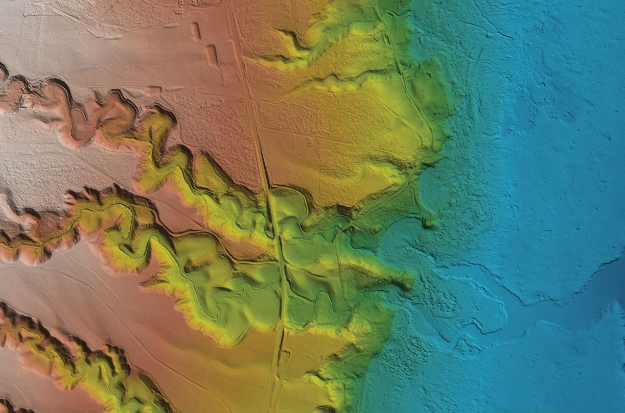
The bathymetric lidar market came into its own in 2020, with many initiatives underway in 2021 to map the near-coastal environment. “Vessel-based sonar has been mapping the ocean depths for some time, but that in-between tidal zone and wave action zone is the challenge,” Lovin said. “It’s of enormous importance due to a host of coastal management, navigational charting and disaster management needs.” Image courtesy of USGS
The use of video conference technology has changed the way we run our industry, as well as many others, forever. Companies already have begun to evaluate whether people will continue to work remotely or go back to a more office-centric setting. It was more of a cultural thing before; we had a lot of these tools, but people worked from home as a luxury. This has forced us to rely on those tools. That’s just been unique to watch.
What advances were made in 2020 in general that will impact the industry moving forward?
The move to the delivery, hosting and managing of data in the cloud made great strides. Throughout 2020, many people did not have access to the office and the data that was stored there. For some clients, they were not at their offices to receive data deliveries. Remote access to that data has been the key. This was a big push for us at Woolpert in 2019 and it has proved crucial to operating successfully in our remote environment. By being able to deliver data quickly and easily in 2020 and in this setting, it also helped accelerate clients’ acceptance of this practice. This remote environment also has helped the industry as a whole embrace this movement to the cloud.
Looking ahead to 2021, what hot topics or trends do you expect to advance or emerge?
Budgets will be a lot tighter after a whole year of COVID-19. Shortfalls in revenue can be supported by multiyear remote sensing data packages that bundle hosting services to greatly discount the price of the data. Software-as-a-service solutions also will help clients save money. You don’t have to spend a million dollars that you don’t have on your server this year because that data can be hosted via subscription software systems like Woolpert’s STREAM:RASTER, for example, that will cover your needs on a limited budget. The best companies out there will help you find creative and innovative solutions that will bring you value now, when you need it the most.
What technologies and solutions are you excited about in 2021?
Bathymetric lidar. The bathy lidar market came into its own in 2020, and there are huge initiatives underway for 2021 with multiple agencies like the U.S. Army Corps of Engineers, the National Oceanic and Atmospheric Administration and the U.S. Geological Survey. The technology for bathymetric lidar has matured, and there are exciting new sensors available. Woolpert was ahead of this curve when it created its maritime market in 2019. Our industry is unique in that we can create or shape our markets to fit our technology.
Now the maritime market is taking off with several years of bathy lidar work ahead. As many of us know, the near-coastal environment is the least-mapped place on earth. Vessel-based sonar has been mapping the ocean depths for some time, but that in-between tidal zone and wave action zone is the challenge. It’s of enormous importance due to a host of coastal management, navigational charting and disaster management needs.
You have been president of ASPRS since March—right around the time the pandemic hit the U.S. How did this shape your presidency and/or affect the trajectory of the organization?
Yes, it looks like I will be the virtual president—serving virtually my whole term. But I am super proud of ASPRS in how the organization reacted and what it accomplished in 2020. When we heard Geo Week wasn’t happening, we decided to host a virtual conference, and it ended up being hugely successful. We conducted workshops in conjunction with the Association for Unmanned Vehicle Systems International (AUVSI) and were active in the Coalition of Geospatial Organizations (COGO), which is like the UN for geospatial organizations.
ASPRS also was approached by a geospatial group in Saudi Arabia that wants to stand up a certification program like ours, so we are working with them. Another group, the Surveying & Spatial Sciences Institute out of Australia, approached us about a knowledge swap after seeing our online materials.
Some of the ASPRS Regions have gotten stronger as well and have had successful virtual meetings. Meeting attendance is up and, due to being virtual, many regions have hosted both attendees and speakers from around the nation.
Personally, my one disappointment from my tenure is that I won’t be able to give out awards in person. That’s the most fun part of being president—when you get to hand out all the awards and recognize the year of great work during the last meeting in March. But for now, I just hope that we get through COVID. Despite the economic uncertainty caused by all this, I hope we all stay healthy physically and that our businesses all survive.
What do think the next five years hold?
There is tremendous opportunity for our industry to integrate deep learning capabilities not only to improve current processes, but to support the next step—which includes autonomous vehicles and systems. Whether aircraft, land-based or waterborne, these vehicles are going to need precise geospatial location information, and that is creating huge opportunities for our industry.
Our whole geospatial world has become mainstream. Everything on your phone is location-based. Who would have thought 30 years ago that our little industry would be so important? The opportunities abound.