
Editor’s note: Coverage continues from YellowScan LiDAR Convention 2026 – Day 1
Day 2 – 16 April 2026
The day’s program was adjusted to cater for the absence of keynote speaker Gottfried Mandlburger, T U Wien, who broke an arm in a skiing accident. Dr. Ulrich Weinbach of Trimble took us behind the scenes at Trimble RTX. He packed a great deal into the time and the description of RTX, with its hundreds of network stations, ionospheric and tropospheric models down to regional level, redundant processing clusters, etc., was compelling. Some sources, such as BeiDou B3 and Galileo E6, now offer a third frequency. Overall, convergence times continue to fall and accuracy, to increase.
Pierre-Augustin Crenn described CDGI’s range of BIM capabilities. CDGI have several UAV-borne systems, including YellowScan. He was passionate about the projects he described, for example BIM catenary for railroads and we were sorry when his time expired.
Geospatial experts from 18 countries swapped tales and studied innovations at the 2026 YLC
Next was Valentin Möller, co-founder and CEO of Most Robotics, based in Wulften am Harz, Germany and YellowScan distributor for Germany, Austria and Switzerland. Using the tagline, “From real-world construction to PDF report,” Valentin described a project for Friedrich Vorwerk, a German energy transition firm whose client was Gasunie Germany. The project was an 87-km pipeline from Stadt to Etzel-Wardenburg to connect an LNG terminal to the national gas grid. YellowScan systems were used, based on Qube 240 lidar sensors and cameras mounted on Trinity Pro eVTOL platforms. The goal was to reduce the €551K/year cost of traditional surveying. The key skills were flight planning, flight operation, data transfer by LTE/5G or Starlink, and processing, which was conducted in CloudStation and several other packages. Construction workers were trained to replace batteries, remove and replace SD cards, etc. Vorwerk has been pleased with results and the collaboration continues. The estimated market is 47,200 km of pipelines, but it goes beyond construction to recurring services such as leak detection with tunable diode laser absorption spectroscopy (TDLAS) sensors.
The tutorial that followed was by Dr. Alexandre Lintz of YellowScan, talking about full-waveform processing and taking us inside the YellowScan software to a level that most customers probably don’t reach, such as the waveform viewer in CloudStation. Some processing begins at data collection, however, before the points even reach CloudStation.
After the break, there were five short presentations and every one of them could have used more time. YellowScan correctly provided us with a packed program – there was no question that YLC offered excellent value for money – but sometimes the audience was left a little breathless, as were the speakers!
Guglielmo Rossi, University of Firenze, talked about the Sicily Protection Centre, part of Italy’s national civil protection service. It also makes Saturn drones, with an unusual perimetal airframe and autobalancing. His project was dramatic – topographic surveys for monitoring volcanic activity on Stromboli Island, using a Quantum-Systems Trinity Pro UAV, Qube Q240 lidar and Sony RX1R II camera. He is testing the Qube 640, a high-performance, lightweight UAV-lidar sensor co-developed by YellowScan and Quantum-Systems specifically for the Trinity Pro and Tactical UAVs. Guglielmo emphasized rapid mapping but counselled risk assessment, better flight management, and cooperation with local flight authorities.
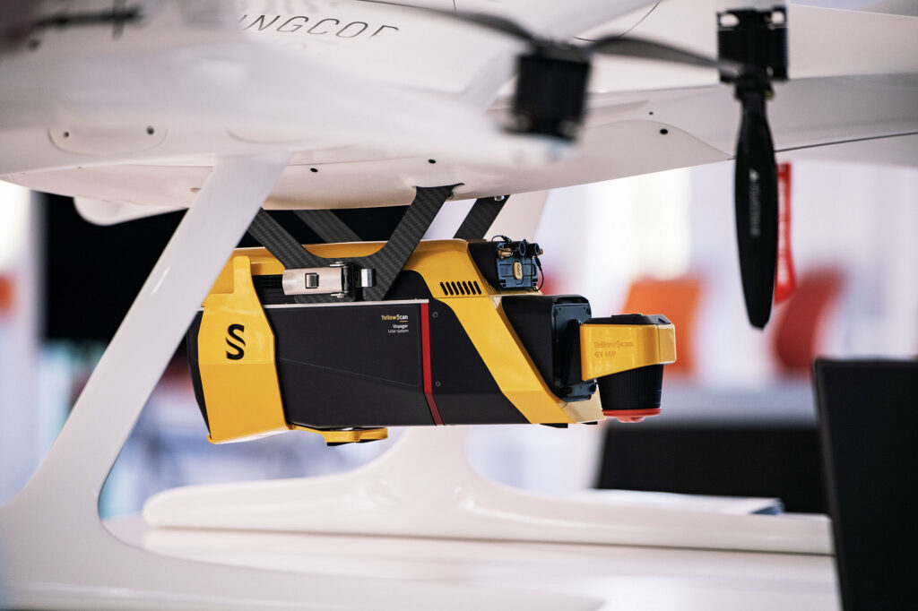
YellowScan Voyager, billed as a high-altitude lidar mapping solution courtesy of 100° scanner with acquisition rates of up to 2400 kHz
Marie de Boisvilliers of L’Avion Jaune (see above) explained that the company flies light aircraft as well as UAVs and offers payloads beyond lidar, for example thermal infrared. Though it concentrates on services, the company is also a distributor of certain payloads and instrumentation. Her first example was coastal erosion management on the Camargue coast in southern France. The topographic part was 1000 ha at 15 ppsm, which she agreed was on the large side for UAV work, yet it took only 2.5 hours with Voyager. The bathymetric requirement was 200 ha at 1 ppsm, but it nevertheless took 12 hours. Planning and working with local flight restrictions were the big challenges. Intriguingly, she said that, despite its higher accuracy, project data was manipulated to fit the French open-access elevation data, Lidar HD.
Now for something completely different. Dr. Thomas Dewez of Bureau de Recherches Géologiques et Minières (BRGM), the French geological survey, talked about color. His argument was that the color systems used by almost all popular software are not as informative as others that are available – so software suppliers need to change. His example, perhaps a mixed blessing, was a facial shot of Tony Blair. He gave a brief, easy-to-follow summary of the theory of color and how it provides information, for example lightness captures high frequency detail, hue and saturation, low frequency. Point clouds are easier to visualize if displayed with a different color ramp. He gave compelling examples and his passion was infective, though he had not nearly enough tim.
Last in the session was Pierre Inisian of SBG, who drew our attention to the date – the 11th anniversary of SBG’s collaboration with YellowScan. He explained that GNSS/IMU hardware and software for bathymetric applications are not the same as for topographic, noting that SBG also works with Teledyne Optech. SBG is open to third-party hardware and has a significant track record in sensor fusion. After listening to this and attending the Trimble Applanix tutorial in the afternoon (see below), I resolved to read a textbook and get up to date, but, to save the meagre funds of a retired photogrammetrist, I am starting with free stuff[3]. The options and technologies are dazzling. One attendee put the obvious question, “Accuracy?” Pierre answered with equal brevity, “One cm, but you have to wait.”
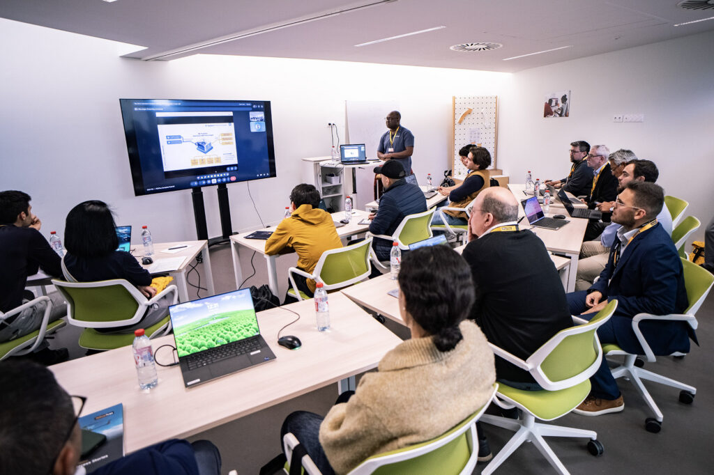
There followed an excellent tutorial by Eerika Simoinem of Terrasolid, showcasing the company’s tools for environmental change detection. She showed how tutorials should be done – a lucid explanation at the right level, leaving ample time for hands-on, which was easy to follow. I had started to entertain doubts about hands-on sessions, but this reassured me with a vengeance. The data set consisted of point clouds of Beaulieu, France, the first acquired with Vx20 in 2019 and the second, with Venturer in 2026. Terrasolid’s statistics speak for themselves: founded in 1989, it has 25 years of point-cloud software development and five major software products, sold in over 100 countries, to more than 3000 customers, including more than 20 national mapping agencies and more than 50 regional agencies.
The tutorial after lunch was equally good: clear presentation, time for hands-on, easy to follow yet help available if required. Chembe Chisense of Trimble Applanix provided an extremely useful introduction to the Trimble Applanix IN-Fusion+ PP-RTX software, built on Trimble CenterPoint RTX correction services and Applanix POSPac. The keys to fast, accurate convergence are the BeiDou-III B1C and B2A signals. The logistical worry of base stations disappears.
Chembe Chisense of Trimble Applanix introduces IN-Fusion+ PP-RTX software, built on Trimble CenterPoint RTX correction services and Applanix POSPac
Inèz Benghezal of YellowScan took the stage in the main auditorium to espouse CloudStation and perhaps trying to redress the balance of the meeting, in which hardware seemed to generate the most excitement, as tends to happen except where it can’t, such as the Esri International User Conference! She pointed out features such as one-click processing, minimal training, unlimited number of flights, full density data, powerful visualization. YellowScan Took Kit (YTK) can be used to launch processes, which can then run unattended.
The last part of the program before the close was a second panel discussion. This was chaired by Roberto Casini of YellowScan and the panelists were Thomas Eder (Nokia), Robert Leake (Quantum-Systems), Gregory Villard (Hexadrone), Karolina Attspodina (Beyond Vision) and Jung Seunghyun (Argosdyne). Hexadrone is the French manufacturer of Tundra UAVs; Beyond Vision is a Portuguese UAV supplier, focused mainly on defense; and Argosdyne is a Korean supplier of UAVs and payloads; all are YellowScan partners.
The audience was anxious for pointers to the future, so Roberto asked the panelists simply to describe the big issues. Gregory opined that payloads will become heavier as customers want more functionality, which in turn will make it hard to deliver capacity to carry the payload and provide autonomy. A UAV battery lasts 30 minutes, a lidar battery, 40. Quo vadis? He cited estimates of European market size suggesting CAGRs in excess of 10% for the next few years. Robert stressed the technology expansion – how rapidly we have developed from being unable to fit lidar on to a UAV to providing systems cheap enough to cause expansion at the low end of the market, where photogrammetry is currently king. Karolina felt that military folk should be more aware of UAV-lidar. Jung spoke for the Asian market and stressed that there’s a lot more to success than just flying. Thomas stressed the importance of automating workflows, increasing ease of use, and integrating UAV-lidar into existing workflows, because large customers have their own processes. Efforts need to be made to expand the market and facilitate the entry of new players in the UAV service space. Noticing how excited we were, Roberto reminded us that UAV manufacturers don’t build for lidar suppliers – it’s the other way round.

YellowScan’s Venturer, billed as UAV NDAA lidar for trusted and compliant data acquisition
Robert expanded on Roberto’s point. Some UAV suppliers, such as DJI, have opted to produce lidar payloads, but Quantum-Systems is one of the many that won’t, preferring to rely on experts such as YellowScan. He advocated removing hurdles, simplifying workflows, doing away with the Yellow Button. “Workflows need to have as few touch points as possible, or people will tinker.”
Karolina echoed the need for simplicity, pointing out that Beyond Vision favors modular systems and has supported more than 80 payloads.
Thomas pointed out that the Yellow Button is now a touchscreen in Mapper Ultra. The UAV industry doesn’t understand standards. The Gremsy interface has helped, but Ethernet pin-outs remain inconsistent. Software integration is less of a problem, but reaching a comfortable situation in hardware integration could take five years. Gregory agreed: there’s mechanical integration, then electrical, then there’s operational integration and system management. Hexadrone makes only one UAV but has accommodated more than 130 payloads – every week it receives two new inquiries. The company has only 20-25 employees, so can’t do lidar, which is where YellowScan comes in.
Roberto asked which verticals seems most interested in UAV-lidar. In Jung’s case it was public safety and military. Thomas went for utilities, linear infrastructure, mining and construction, markets that the UAV-lidar industry should try to understand better. Karolina chose mining and military. Doubtless the audience hoped that her prediction about post-war reconstruction becomes reality soon.
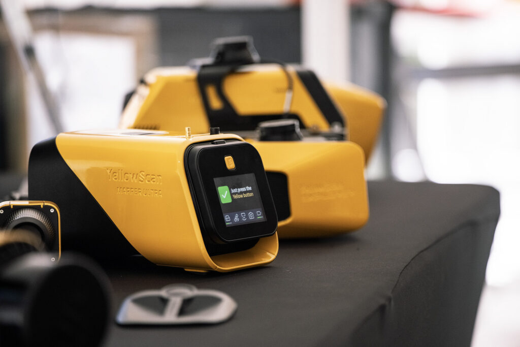
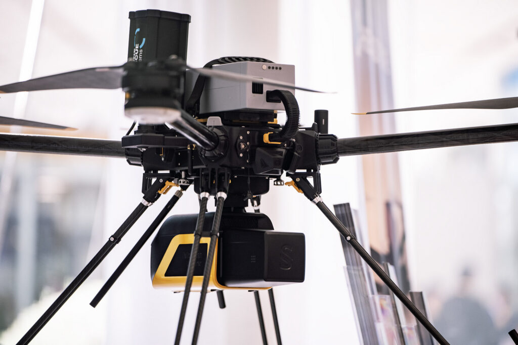
YellowScan’s famous “Yellow Button” is now a touchscreen on the new Mapper Ultra, a system that doubles performance to 500,000 pts/sec, with up to 7 returns, all in a package weighing 1.94 kg
Robert moved the panel on to predictions for the next five years. Gregory plumped for automation, noting that, as time went by, it would be unrealistic to expect one pilot per UAV. We need autonomous solutions such as drone-in-a-box. Robert agreed on autonomy but warned about regulatory drag. BVLOS is making progress, but if permissions are required for a particular mission, then it’s not scalable. Karolina concurred: Beyond Vision is already producing collaborative autonomous systems, such as swarms. Defense agencies will change: they worry about systems lasting 50-70 years, yet UAV solutions are obsolete in six months! Sodium batteries are heavier, but are cheaper, charge faster and last longer than lithium-ion. Jung agreed on full autonomy but acknowledged the tightness of the Korean regulatory environment. BVLOS still needs permissions; 24/7 operation is distant. Thomas talked about the marketing side – attaching a service to a product such as UAV-lidar. Gregory said that getting rid of product coming from China was easier said than done.
Roberto opened the audience Q&A. Someone was worried that 90% of UAV manufacturers have moved to military business. Karolina acknowledged that that’s where the money is, but Beyond Vision had started with some agricultural spraying clients and still has them. Robert agreed on the greater available of funds in the military arena.
The panel ended with discussion of how to improve YLC to ensure that people return, perhaps by facilitating visits to the YellowScan facility.
Michel and Tristan closed the meeting by thanking participants, sponsors, partners and colleagues. They listed the verticals that had been showcased: risk assessment and mitigation, mine detection, powerlines, pipelines, highways, BIM, heritage, archaeology. The military interest was enormous, but YellowScan would stick to its ethical position described at the beginning of the meeting. BVLOS is now routine, especially with linear infrastructure. Time series data plays a growing role. Tristan expressed satisfaction with the workshops, through which the audience had crowdsourced ideas. There was clear demand for real-time monitoring of data and associated QC. Customers want more from the data. BIM is one aspect, color maps another. Autonomy is developing. YellowScan is also looking at the search-and-rescue market.
Michel reminded the audience that some YellowScan customers operate crewed aircraft or helicopters. Indeed, the former are often cheaper than large UAVs. YellowScan systems work on all these platforms. Fly and Drive is developing too. Come back in 2028!
Reflections (by Florian Caraveo)
From an internal perspective, the YellowScan LiDAR Convention 2026 truly reflected who we are as a company. Since the very beginning, YellowScan has been driven by a constant pursuit of innovation not only through technology itself, but through the way we approach the industry.
We remain deeply connected to end users, allowing us to build a global, customer-centric ecosystem designed to make the complexity of lidar technology simple, accessible, and efficient.
In the past, YellowScan organized LiDAR for Drone, a user-focused event designed to connect directly with our community and share expertise alongside our teams. The YellowScan LiDAR Convention represents the natural evolution of that initiative.
The idea behind this new format was to go beyond the technology itself and showcase the full ecosystem surrounding lidar. Our goal was to create a complete experience for surveyors, drone professionals, and geospatial users by offering dedicated sessions around LiDAR technology, UAV platforms, workflows, and software solutions.
At YellowScan, we have always embraced a “drone-first” strategy. Designing lightweight, high-performance lidar systems for UAV integration is deeply rooted in the DNA of our development team. This expertise has enabled us to build seamless integrations with more than 30 UAV partners worldwide.
For this edition, Michel and Tristan introduced collaborative workshops, running in parallel with the tutorials, aimed at exploring together the future of geospatial technologies and their applications. Bringing together lidar users, drone pilots, geomatics distributors, and surveyors created a unique environment for open discussion and shared perspectives. The workshops focused on three key themes:
- The evolution of geospatial methods from the past 25 years through to 2050
- The major obstacles the industry still needs to overcome
- The future of support, collaboration, and user experience
I had the opportunity to lead these workshops alongside my colleague Lisa Urfer, a surveying engineer at YellowScan. We were genuinely impressed by the level of engagement from participants, who openly exchanged ideas, challenged perspectives, and collaborated across different backgrounds before presenting their final pitches at the end of each session.
Technology is evolving at an incredible pace. Workflows are becoming more efficient, data acquisition is growing exponentially, and AI is rapidly transforming the way repetitive and complex tasks are automated. In this environment, staying close to users is essential to continue developing meaningful and practical solutions.
The future is no longer just about collecting more data, it’s about making that data actionable, accessible, and secure in real time.

Conclusions
YellowScan is one meeting behind EAASI – see Ada Perello’s article in this issue[4]. The organizations’ goals, however, have parallels. YellowScan stages well orchestrated, skillfully located events that are popular with customers but also attract attendees from the research and supplier communities. At the same time, it has developed its own topobathymetric UAV-lidar sensor that encounters little competition and is working on a topographic sensor, presumably to meet some performance goals that sensors from the automotive world don’t quite meet. It has crossed the transom from integrator to manufacturer. In the process, it has amassed a formidable team of partners – drone suppliers Hexadrone, Quantum-Systems, Nokia, Beyond Vision, Argosdyne and Wingcopter; GNSS/IMU suppliers SBG Systems, Trimble Applanix and Emlid; and software specialists Terrasolid and Lumi DB. It has an increasingly far-reaching sales network. Underneath all this success, however, is a robust company culture in the low-key, European mold, and a fine workforce blessed with English language skills. The hendiadys president-CEO model appears to function smoothly. The practice of seeking and reacting to customer feedback is established in its culture. The customers came across as experienced and competent, i.e. flying successful UAV missions for a wide variety of projects and applications is quotidian – the “wild west” days are over. Strangely, there was little mention of the issue raised often at Intergeo and Geo Week: it’s easy to capture data these days but much harder to assess its quality. The industry has matured to the point that rigorous QC is embedded in firms’ cultures. YellowScan speaks highly of its competitors, such as GeoCue (and its French owner Microdrones), LiDAR USA and Phoenix LiDAR Systems. With players such as these striving for success, technology is bound to advance and customers to benefit. We look forward to the 2028 YLC and eagerly anticipate the company’s selection of Provençal venue.
Acknowledgement
LIDAR Magazine is grateful to YellowScan for the invitation to attend and report on the 2026 YellowScan LiDAR Convention and for bearing some of the associated costs.
###
[3] There’s no excuse for ignorance! At least two useful sources are freely available on the Internet:
- Anon, 2023. An Introduction to GNSS, 3rd edition, Hexagon, Calgary, 109 pp (https://novatel.com/an-introduction-to-gnss).
- Li, B., Z. Zhang and W. Miao, 2025. GNSS Real-Time Kinematic Positioning: Theory and Applications, Springer, Singapore, 313 pp.
[4] Perello, A., 2026. Dubrovnik and the long game: EAASI’s seventh summit takes stock of a changing industry, LIDAR Magazine, 16(2): 38-41, Spring 2026.