With GIS we can repair our planet – or are we just preaching to the choir?
The 45th Esri International User Conference took place in the San Diego Convention Center (SDCC) and several surrounding hotels on 14—18 July 2025. Buildings and sidewalks were bedecked with colorful Esri designs and quirky slogans. Around 20,000 customers from more than 130 countries turned up, with three times as many online, some of them at watch parties. For us gentlepersons of the press, the event began on the Sunday evening with a reception to meet Esri executives. I spoke to Brian Cross, corporate director, professional services, about uncertainties in the market occasioned by current policies, especially in the US federal space. He admitted that there had been effects, but contended that Esri’s market is sufficiently diversified to cushion such shocks. In view of the size and composition of the conference attendance, I was in no doubt that he was right!

On Sunday evening I spoke to Richard Cooke, corporate director, global business development, then at a luncheon on Monday to Beau Legeer, director, imagery & remote sensing. We reminisced about the ENVI software, now in the hands of NV5, whose team includes Jeremy Metcalf, whom I have known since he was at the Naval Postgraduate School in Monterey. I spoke to him too during the conference and it is apparent that ENVI and its IDL powerhouse continue to be indispensable to many.
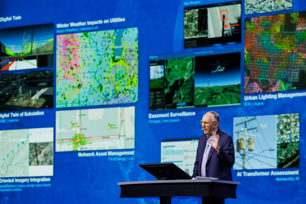
The multitudes flocked to the doors opening for the big plenary on Monday morning and we were treated to beautiful graphics and engaging videos until Jack took the stage bang on time. The videos included the expected messaging about GIS integrating everything, breaking down siloes, leveraging scarce resources, geometry at the beginning of sustainability, geography making the world a better place etc. Esri has more than 10 million users in over 700,000 organizations. Jack covered the business side in a few sentences – the company is healthy, growing and spends a lot on R&D. It is run by 24 directors. In addition to software there are three pillars, technical support, professional development, and professional services. There are over 3000 business partners. That’s the dime tour!

As usual, the plenary was superbly orchestrated, with a procession of Esri experts and customers taking the stage to highlight particular applications and achievements. Sud Menon, director, products & technology, was as eloquent and engaging as ever – he has enormous responsibilities and absolutely on top of everything. He introduced two related themes that were oft repeated through the conference: AI and AI assistants are everywhere and are making a huge difference to customers’ experiences and productivity. As I listened, I was struck with the almost incomprehensible volume of data available to Esri users through The Living Atlas. As Jack and Sud described integrations with other companies, such as IBM, Salesforce, Adobe, Microsoft, AWS, SAP, and Autodesk, the ubiquity of ArcGIS was inspirational. There were many demonstrations and examples, but I enjoyed the description of Chattanooga’s 311 system and the finding of cracks in sidewalks. The range of examples presented by Esri customers was impressive and it’s surprising how much we are all affected by GIS behind-the-scenes at companies such as CVS and Aetna[1].
I was delighted, however, that the morning ended with a magnificent presentation by the Esri Stuttgart team on Reality Mapping, the part that began with the acquisition of nFrames. Naturally, there were breathtaking fly-throughs, including the public library and the Hauptbahnhof reconstruction in Stuttgart, though there were several examples from other countries, and we relished the week’s first mention of Gaussian splatting.
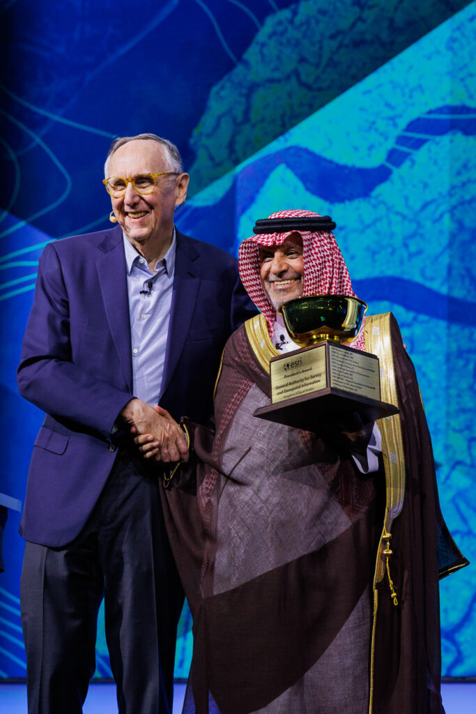
After lunch, Brian Cross joined Jack to present three big awards, to King County, Washington, GEOSA and CalFire. In his words of acceptance, Dr. Eng. Mohammed Yahya Al Sayel, President of GEOSA mentioned the new United Nations Global Geospatial Ecosystem Centre of Excellence (UN-GGECE) in Riyadh. CalFire has a fleet of aircraft, not all of which drop water and retardant. Their presenters included Logan Hansen, who bounces around in the turbulence while plotting the extent of a fire, which is then immediately beamed down to ground crews. The goal is to extinguish 95% of fires before they reach 10 acres. The size and expertise of CalFire is reassuring. I spoke to their team during the reception later and learned how they are organized and how they are related to local fire brigades, for example where I live.
The plenary ended with two perennials: the keynote and the school presentation. The former was given by Dr. Kirk Johnson, curator the Smithsonian Museum of Natural History. The number of artifacts in the collections he manages runs to 148 million and, unsurprisingly, 73 of the museums round the world with more than 1.1 billion objects in their collective care are clubbing together to facilitate digital access.
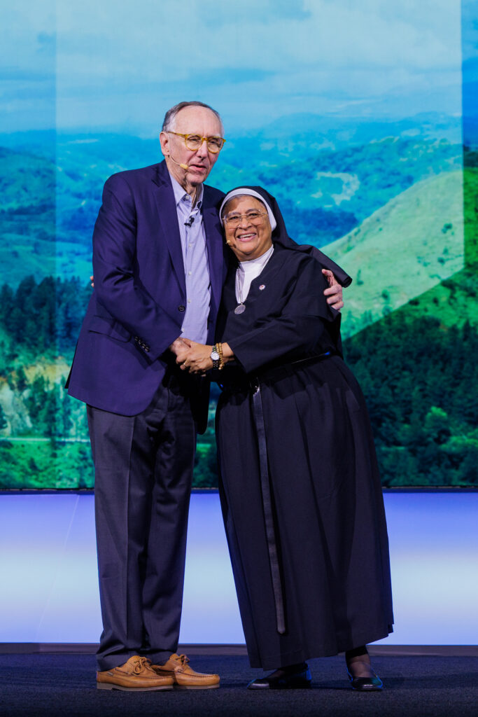
Sister Esther and several of her pupils from a school in Panama that Jack had come upon during a visit last Christmas ended the afternoon with extremely professional presentations. I had an inkling that some of the students’ work was dependent on expert teaching – surely they aren’t really more familiar with SAR and unsupervised classification than I was I reached my postgraduate years? Anyway, I was spellbound!
The Map Gallery reception was packed. Is the event getting bigger every year? The maps were as professional as ever and one marvels at how Esri’s staff selects from the thousands that must be submitted.

I was meticulously hosted by Robby Demming of Esri and he organized several presentations for media folk. The first was “OPTICS 3D active digital twin ArcGIS Unity Gaming Engine,” by Darrell Keach, business systems manager, Port of Corpus Christi Authority. This reinforced the reality that digital twins are in use in critical environments all over the world, with both updates and applications in real time. The scope of the one in Corpus Christi, in terms of content and value, is increasing all the time.
There were two presentations in Robby’s series about facilitating public involvement in planning decisions. The 2020 startup inCitu provides a phone app that allows one to walk in a scene, hold the phone at eyelevel and see a proposed structure against the current cityscape as captured by the phone’s camera. “Notices on fences don’t quite hack it,” said CEO Dana Chermesh-Reshef, who took us outside to see it working. Rather, her goal is, “… turn static files into elegant immersive experiences, engaging stakeholders in real life … bridge gaps between technical and public understanding.”

Then “Downtown Wake Forest: A vision for 2035 through immersive 3D modeling,” from Houseal Lavigne and the city of Wake Forest, showed how, through immersive displays on standard monitors together with an Xbox controller, they enabled the public to visualize what they would see from the existing historic high street if new buildings of three, five, eight or ten storeys were erected in adjacent streets. These innovations improve both the enjoyment and quality of public comment.
One of the recurring topics that caught my interest during the week was airports. These are such a critical, fascinating part of the world’s infrastructure that our future is dependent on their safe, efficient, fast operation. During the opening plenary, Josephine Young and Guy Michael gave a captivating presentation on SFO’s digital twin and its uses. Data, including aircraft movements, is being ingested continuously and the visualization and decision-making functionality is amazing. GIS at SFO dates back 17 years. The indoors part covers 80 million square feet!
I didn’t have much time to attend technical sessions. On Tuesday morning, however, I attended a session (selections were tough, as there were dozens of parallel sessions in dozens of rooms, all day, every day…), “ArcGIS: Tips and tricks for working with lidar data,” by Arthur Crawford and Clayton Crawford of Esri, who took us through many of the ArcGIS capabilities with LAS, LAZ and zLAS files, centered on LAS Dataset and Point Cloud Scene Layer. This attracted more than 200 participants, a large number given all the offerings available, reflective of lidar’s status in the Esri world.
Returning to the airports them, on Wednesday morning I attended “3D&BIM lead airports to indoor GIS” There were two presentations, “Take off at DEN: Digitally transforming legacy systems into a modern airport GIS,” by Chelsea Seiter-Weatherford, geospatial manager, Denver International Airport, and Patrick Gahagan, aviation GIS delivery manager, HNTB, and “Leveraging lidar and GIS for smarter asset management.” The latter was about the Metropolitan Airports Commission (MAC), responsible for Minneapolis-St. Paul International Airport, and was presented by Theron Hodel from MAC’s contractor, NV5, who mentioned successes with the NavVis VLX 3 (listen to my podcast with CEO Felix Reinshagen!). He concluded, “It’s a beautiful thing, this is what we’re striving for.” The animated, well informed Q&A at the end emphasized the enormous interest in these operational digital twins.
The last technical session I attended was, “ArcGIS Pro: Preparing your data for the future NSRS 2022 shift,” by Melita Kennedy and Bojan Savric of Esri. The new coordinate reference system from NOAA’s National Geodetic Survey will be foundational to all North American geospatial work imminently, so it was reassuring to learn that Esri experts are on it. Some of the content was accessible only to those with a decent grounding in geodesy – and the room was packed!
The Imagery Summit used to be held over the weekend before the main conference, but this year was on Tuesday afternoon, introduced and moderated by Beau Legeer. The focus was very much on uses cases and there were strong ones, including Cantabria, Qatar and British Columbia.
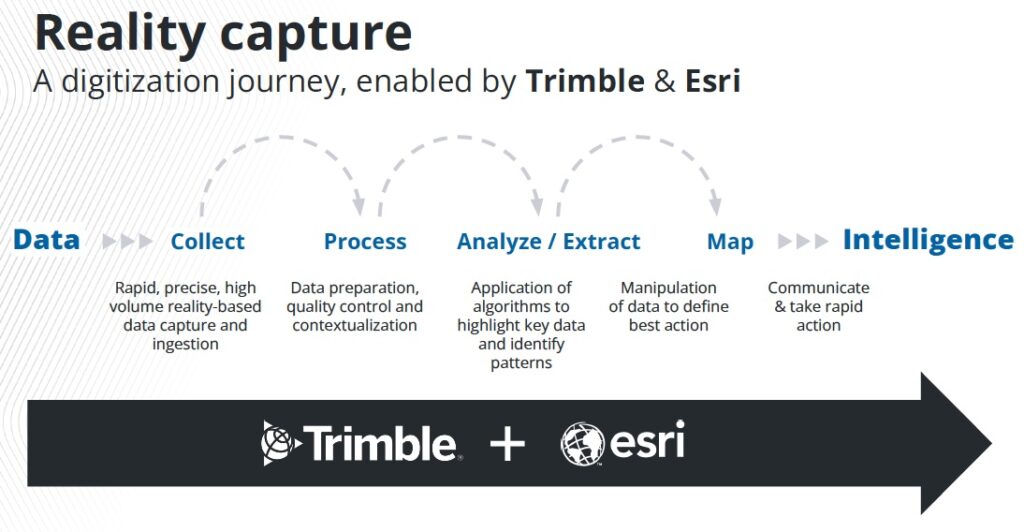
Trimble had set up a meeting for me on their booth and I had a super half-hour with Gareth Gibson, global marketing director, and Joe Sass, mobile mapping applications engineer. There are numerous incremental developments going on, both hardware and software. We talked about the MX line of mobile mapping systems. I had not realized that the lidar components are Trimble’s own, from their operation in Jena that had its roots in the surveying part of Carl Zeiss Jena.
There’s little space for detail about the other booths I visited. I followed my interests and was drawn to Mach9 – see my comments about this company at the Hexagon event. The SAR constellation ICEYE now has 54 satellites operational, so it’s growing handily. The booth staff at ASTERRA, which uses SAR to find water leaks and has been featured in LIDAR Magazine, were cheerful too. Don’t confuse it with ASKTERRA, a web application from Redcastle Resources for mapping land cover and vegetation changes from Landsat and Sentinel-2! Airspace Link counts the number of registered drones in the US – approaching 1.07 million. Hydrosat is a Luxembourg-based company in the early stages of building a constellation of satellites with RGB, NIR and, importantly, LWIR bands for multiple applications, some of which seem to be US-federal in focus. Thanks to Nelli Gyöngyösi at Mach9, Alex Bernatz at ASTERRA, Mike Bennett at ICEYE and Ryan Hackney at Hydrosat for keeping me up to date.
Driving home, I reflected. Everything seemed positive, the software evolving, more widely used than ever, by everyone from schoolkids to pensioners. Yes, it has the power to help solve innumerable environmental problems. But remember that we voted, in our millions, for policies that include a big future for fossil fuels, emasculation of electric vehicles and renewable energy, deregulation of pollution, and so on. The question is not about the power of GIS but how we can make the jump to persuading electorates and politicians that the answers it can generate have value. Can we do that in time? Jack had begun Monday with memories such as Rachel Carson’s Silent Spring, Paul Ehrlich’s The Population Bomb and the first photos from space. How will it end?
Inside their “swag bag”, registrants were given a copy of Esri Map Book Volume 40[2]. Jack had mentioned Esri Press early on the Monday – it has already published hundreds of books. In reports about this conference in previous years, I haven’t commented on this fine production, despite owning more than a third of the series. Volume 40 contains a preface from Jack and 80 pages of attractive maps submitted by Esri customers. Perusing these is a pleasure. Indeed, readers of LIDAR Magazine will enjoy, on page 8, NV5’s rendering from a lidar point-cloud of a building in Spokane, Washington. Those whose concentration wanders away from lidar may enjoy maps of expenditure on sneakers in Texas or a Spilhaus projection of the world’s oceans. Pages 42-43 are a collage of the covers of all 40 issues.
While the concept of climate change is polarizing per se, the persistent mapping of phenomena that can be explained by it is uplifting. This book is a fitting memorial to another immensely informative, enjoyable but deeply worrying Esri event.
[1] A very recent example of these cooperations is Esri’s announcement on 29 July 2025 of its partnership with Space42 and Microsoft in the Map Africa Initiative: https://www.esri.com/about/newsroom/announcements/esri-microsoft-and-space42-join-to-launch-map-africa-initiative.
[2] Anon (eds.), 2025. Esri Map Book Volume 40, Esri Press, Redlands, California, 86 pp.