For this installment of Quick Takes, LIDAR Magazine accepted an invitation from Quantum Spatial Inc. (QSI) to interview senior vice president Mark Meade. Managing editor Stewart Walker conducted the interview by teleconference, hosted by Maria Bradley of Kickstart Consulting.

Mark Meade, senior vice president, QSI
LM: Mark, it’s great to be talking to you again. How are you, and Quantum Spatial, doing in the current crisis? Your CEO sent a very positive and optimistic letter to customers and partners on 17 March saying that you were weathering the storm.
MM: We are doing remarkably well, especially given these very challenging times. Two keys to our success were early recognition of the threat and swift action. We started monitoring the coronavirus outbreak in February about, the same time as the country recorded the first virus-related death, and immediately activated our business continuity plan. Our plan includes a specific response action framework for a pandemic. I serve on our Response Task Force and we have been meeting weekly for two months.
Editor’s note: A PDF of this article as it appeared in the magazine is available HERE.
The safety and security of our employees and the communities in which we operate continue to be our top priority. We took action in most locations before government mandates. Moreover, serving the mission of each of our clients is also key, and we haven’t missed a step.
Our success is a testament to our professionals across all job functions – from acquisition to IT to our project management and production teams. It is amazing to look back at the last three months and reflect on the changes we’ve witnessed. We have found new ways to accomplish many things from home without the need to travel. And we have added new words to our vocabulary. Zoom takes on a whole new meaning for all of us.
We have continued to execute at the high level required for the essential nature of our work. But I don’t want to lose sight of the overall damage to our economy, the number of lives lost in this pandemic, and the unique cruelty of this virus. My hope is that we learn a lot from this and change the way we live our lives and run our businesses.
LM: What percentage of your employees are successfully working from home? Indeed, your software development manager recently posted tips about this on your website.
MM: Some of our professionals have been working from a home office for years. The lessons learned have really helped the rest of us these last few months. Jeff Skahill’s post that you mention was both valuable and timely. Our eight physical offices are largely empty today. There are two general exceptions: small teams that receive raw data shipped from our acquisition crews who must put this data through the paces of QA/QC immediately to ensure it will meet client requirements, and the individuals who package and ship the final deliverables. Otherwise, about 95% to 98% of our staff is now working from home. Maintaining social distancing among our 620 employees is really important for us to help flatten the curve.
LM: LIDAR Magazine understands that many of your production, sales, marketing and back-office staff can work remotely, but what about your aircrews? How do you operate aircraft that need more than just a pilot? How do you collect data? How do you organize refueling and maintenance?
MM: Acquisition is completed with an air crew that includes a pilot and sensor operator. The operator is in the back of the cabin with the sensor and flight management system. We continue to operate as per all CDC, federal, state and local guidelines for businesses conducting essential services. We have provided crews with all the tools recommended by the CDC, including masks, disinfectant, gloves and hand sanitizer.

Lidar acquisition from fixed-wing aircraft dominates QSI’s flying program. In the Pacific Northwest, for example, there are often considerable challenges due to terrain and coniferous vegetation.
The logistics for acquisition have become more challenging. We have moved away from hotels to residences, securing private accommodations. This allows us to avoid crowds and provides kitchens for the preparation of private meals. Most airports are operating on a regular basis and we have a large hangar and our own highly qualified staff of mechanics in Sheboygan who take care of most of our major maintenance. Acquisition is more challenging today, but our flight management team is doing a terrific job navigating those challenges.
LM: Despite the pandemic, you are working on many projects. Can you give us a flavor of some of the most exciting ones? Are there any obvious trends in the type of business you are winning, e.g. less vectors/more orthos, less imagery/more lidar, less airborne, more UAV, bigger areas, higher resolution? I listened to the Geo Week webinar last week and the message about lidar certainly was higher density, more frequent data collection, bigger areas, lower cost.
MM: Our scale and the diversity of our solutions enable us to work on many incredibly exciting projects. We just completed a very large project that fused hyperspectral data with high-density lidar to identify the species and health of deciduous vegetation. This was specifically related to ash trees that are falling prey to the emerald ash borer and serve as a major risk to above-ground infrastructure for electricity. We were told this was the largest high-resolution hyperspectral project ever undertaken anywhere in the world.
Hyperspectral imagery was fused with high-density lidar, allowing us to group lidar returns for each tree, and assign species health from the hyperspectral data to the 3D tree representation
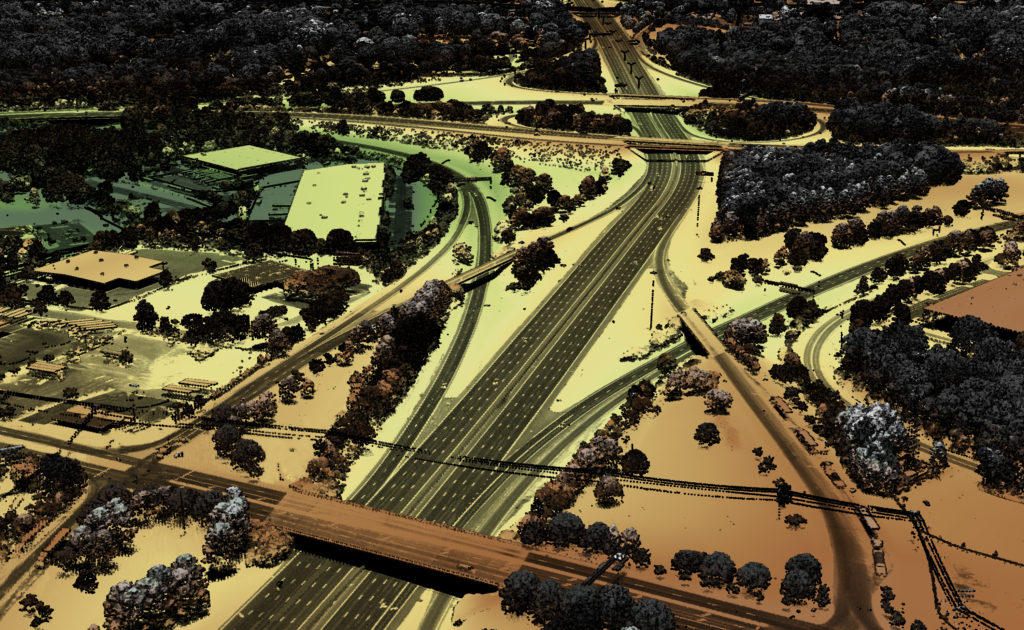
In terms of scenic locations, few projects can compare to the natural beauty of Yosemite National Park. We are nearing the completion of 1243 square miles of lidar there at QL1 specifications. We couldn’t resist flying Half Dome and El Capitan at much higher densities. We have 60+ ppsm lidar point clouds in those limited areas and the detail is spectacular. Finally, the engineer in me enjoys a deep dive into the data. We just completed acquisition of three independent datasets for a two-mile corridor for a Department of Transportation. From that we have traditional lidar captured at 600 feet from a rotary platform; nadir and oblique imagery, and high-density lidar captured from our new comprehensive low altitude sensor solution (CLASS) pod, at 500 feet from rotary; and ultra-high-density lidar captured using a UAV platform from 250 feet.
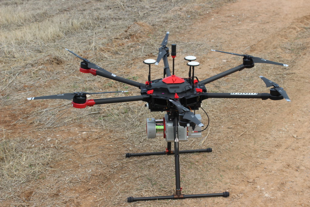
UAVs provide considerable capabilities for smaller project areas that require high-accuracy, high-density point clouds from lidar
In terms of the market trends you mentioned, more orthos and less vectors has been in place for years. But vectors still have their place in certain applications. Lidar and the downstream analytics from these data account for about 75% of our revenues. For us, fixed wing acquisition dominates, rotary is significant, and UAVs are used in limited but important applications, as is ground-based mobile mapping. Higher densities make great headlines for all the right reasons and provide extreme value. And large project areas are the norm as the benefits of the data are clearly understood. We completed about 175,000 square miles of wide-area lidar coverage and 75,000 linear miles of lidar for electric and natural gas lines last year alone.
The Geo Week webinar about lidar was spot on. But I suggest there is more, and this addition is critically important. We have been investing heavily in developing complex algorithms and analytics that allow us to extract added value and more informed answers from these point clouds. The first two drivers you mentioned – higher density and more frequency – open the door for many advanced applications.
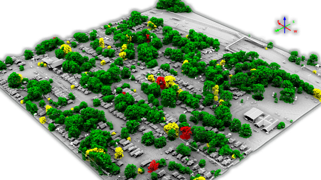
High-density lidar at 30 ppsm provides accurate modeling of the built environment and opens the door for advanced remote sensing applications
LM: Owing to Covid-19, geospatial professional and conference programs have been canceled or postponed. How is that affecting you?
MM: The impact is significant. We typically exhibit at 90 conferences each year and attend 60 more. Over the last two months we have seen cancellation or postponement of all of these stretching to midyear. Typically, these conferences provide a venue for us to visit with clients, hold key meetings with tech providers, catch up with our partners, and expand our knowledge base by attending technical programs. These functions continue, but all virtually as of now.
Our senior leadership team has been conducting virtual meetings since 2013. Similarly, our customer focused team leaders are geographically dispersed and make great use of virtual meetings. We have extended these practices to meet the diverse needs in all other areas. Some of these new practices are sure to replace old ones as we move into the future.
LM: At the end of last year, it was announced that [and I’m just quoting bits of the press release] NV5 Global, Inc., a provider of professional and technical engineering and consulting solutions, had acquired Geospatial Holdings, Inc. and its subsidiaries, including QSI, the nation’s largest independent geospatial analytics firm. NV5 acquired QSI in an all-cash transaction for approximately $318 million. NV5 expects the acquisition to expand and diversify NV5’s customer base to include new federal, state, and commercial clients in the high-growth geospatial data analytics market. Please comment. Are there any other companies in the NV5 portfolio with which QSI has discovered synergies?
MM: The sale of QSI by Geospatial Holdings, Inc., to NV5 was completed near the end of 2019. Geospatial Holdings, Inc., was the parent company of QSI. We just finished our first full quarter as an NV5 Company. The transition has gone really well. NV5 has acquired several other large companies over the last few years, and their experience with those transactions has been key to our successful integration. The core values of NV5 and QSI are incredibly similar, and that too has been quite important.
I am really encouraged by the expertise and professionalism of everyone at NV5 that I have met and the overall capabilities of the offices I’ve visited. They have been very welcoming and I love the diversity across their five verticals. NV5 and QSI have worked on many projects together over the last couple of years, so there were synergies already in place before we even joined NV5. We have identified a number of opportunities for additional synergies, which we are currently pursuing and implementing, particularly in support of utilities, which is a key market for NV5 and QSI.
LM: It was announced on 2 April that QSI had been selected as a prime consultant for a five-year, $40 million shoreline mapping support services contract for the NOAA National Geodetic Survey (NGS). QSI’s expertise in the collection of topobathymetric lidar and the associated data analytics is a critical capability NOAA seeks to leverage as they continue to monitor coastal resources and ensure the safety of navigation. Please tell us more about this success. From what you said in the teleconference, you have flown a huge area for NOAA already!
MM: Our April selection was as one of four companies that will perform NGS shoreline mapping over the next five years. The maximum contract value for all firms combined is $40 million.
Your comment at the end is regarding an $18.6 million task order recently awarded under a previous contract with NGS. Acquisition was recently completed and we are well into production. This task order includes collection and processing of topographic and bathymetric lidar data and aerial imagery along the North Carolina coast, the Florida Panhandle, Guam, and portions of the Commonwealth of the Northern Mariana Islands.
LM: I had the privilege to be invited to your Acquisition Summit 4.0 in Corvallis last October. It was a superb meeting and I hope that I am invited again. We learned about QSI’s sophisticated flight planning and about some exciting QSI initiatives, for example: a multi-sensor system in a pod for helicopter use along corridors; a robot for acquiring data inside electrical substations; a rapid response capability; an increasing focus on topobathymetric lidar; and the growing demand for hyperspectral data and information derived from it. Could you comment on how some of these are moving forward?
MM: Your return invitation is in the mail (but don’t buy your airline ticket yet, for reasons I will soon explain). Hosting the Acquisition Summit is truly rewarding. Last year we brought 174 acquisition professionals together from around the world for the event. I have known many of these folks for much of my professional career and have an immense level of respect for what they do and how they do it. The Summit provides the perfect venue for us to share our knowledge and technological advances with our acquisition partners and grow our overall capabilities.
All the initiatives you mentioned are either ahead of schedule or complete. Our multi-sensor CLASS solution has completed several hundred hours of rotary acquisition of nadir RGB and NIR imagery, forward-looking RGB oblique imagery, and high-resolution, high-accuracy lidar from the integrated sensors. We are now fabricating our CLASS II sensor, which will be deployed soon with upgraded models of Phase One cameras and the new Riegl VUX-240 sensors.
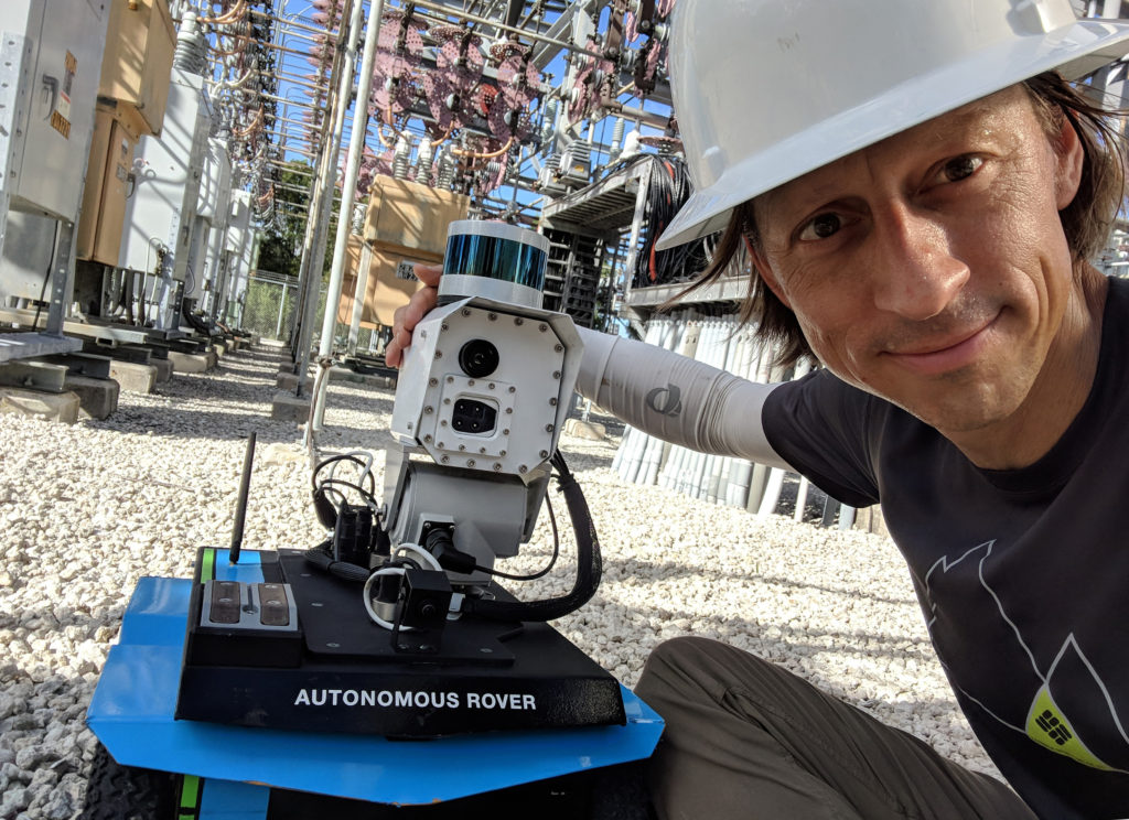
QSI’s Autonomous Roving Inspection System (ARIS) remotely acquires lidar, RGB imagery, and thermal infrared data for electric substations
We have deployed 10 Autonomous Roving Inspection System (ARIS) robots that collect lidar, multispectral imagery and thermal infrared data from a small ground-based robotic platform. They are deployed in electric substations and reduce the need for boots on the ground.
Our rapid response capability has been used on several projects and, for near-real-time turnaround, the capabilities are significant. Earlier I mentioned the world’s largest hyperspectral project. Hyperspectral provides the ultimate source data for complex applications of remote sensing.
LM: Participants at the Acquisition Summit last year were given copies of your company’s book, Captured in Time. Could you tell us more about this project, designed to bring the beauty of the Earth, captured from aerial photography, to a wider public?
MM: We typically complete projects in all 50 states and many international locations over the course of a year. One month we are in a helicopter over Kilauea capturing the eruption, the next collecting fixed wing data in Yosemite, then flying ancient Mayan archeological ruins in the jungles of Honduras. Our opportunities for capturing stunning work-related images are limitless.

The lava flow from the 2018 eruption of Kilauea on the Big Island of Hawai’i clearly shows the destruction from the eruption
Our professionals in the field and office know we love to share the truly unique beauty of nature and engineering wonders with our clients and peers. Captured in Time provided the perfect canvas to do so. It helps communicate the value of the data we acquire, the unique beauties of this vast world, and the way we use our acquired data to develop the answers our clients demand.
LM: Are you planning to run the Acquisition Summit in 2020? How do you think things are looking?
MM: We have dates on hold for early September in Big Sky, Montana. Obviously Covid-19 and the associated health risks and economic impacts are still very much in the mix. We don’t know how this will play out, but plan to make the final call in early July for this year’s event. Stay tuned.
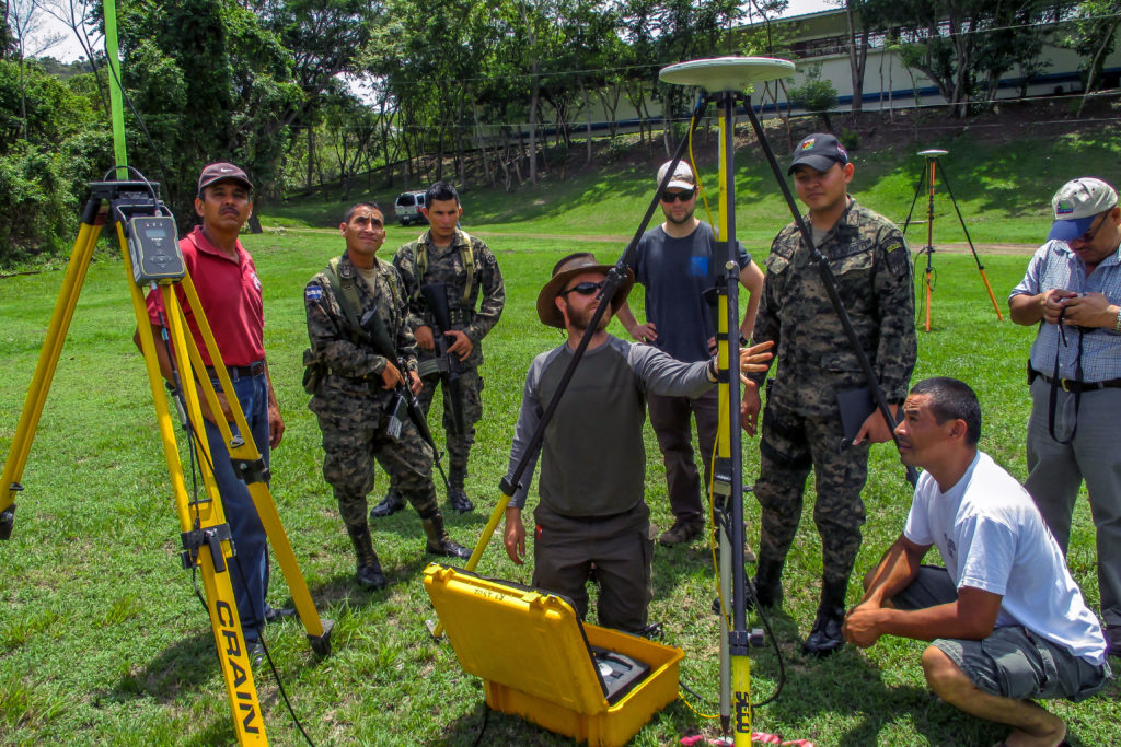
Few projects garner as much attention as our ground surveys for the lidar acquisition at the Copan archaeological site of the Maya civilization in Honduras.
If we can’t do an in-person Summit, then we plan to hold a scaled-down virtual meeting around the same time. That will make the 2021 Summit a grand celebration when covid-19 is only a distant memory for all of us.
LM: Mark, I understand that you have just been appointed as a member of NGAC (National Geospatial Advisory Committee), which is a Federal Advisory Committee sponsored by the Department of the Interior. NGAC is authorized under the Geospatial Data Act of 2018 and reports to the Chair of the Federal Geographic Data Committee (Secretary of the Interior). Please tell us about the work of this important committee and how you expect to contribute.
MM: I am both excited and humbled by the appointment. This profession has been very good to me over the last 36 years and I see this as a great opportunity to give back. When I received the official notice a couple of weeks ago, I was especially appreciative to see the full list of committee members. I have worked with many of them at different points in my career. It is a terrific group that I respect greatly.
The committee is charged with providing advice and recommendations for federal and national geospatial programs, the National Spatial Data Infrastructure (NSDI), and reviewing and commenting on geospatial policy and management issues. I really look forward to being actively engaged in this work.
LM: We first met serendipitously when you (working for Photo Science at that time) were in Emeryville, California, to work on the integration of a company you acquired, HJW Geospatial. QSI itself is the result of M&A. Can you comment not only on the successful creation of QSI from mergers but also on the integration of the various companies you have acquired? How does QSI divide up its operations across its multiple sites?
MM: Yes, that was in 2011. Quantum Spatial was created a couple years later from the merger of three of the nation’s largest geospatial firms – Aerometric, Photo Science and Watershed Sciences. Aerometric and Photo Science had each acquired many firms over their history and HJW Geospatial (Photo Science) and Mark Hurd Aerial Surveys (Aerometric) trace their roots back to 1930. Mark was a fighter pilot in WWI and actually built one of the first aerial cameras after leaving the service in 1922. We still retain that today. Finally – and I find this amazing – together we have completed more than 250,000 hours of fixed wing acquisition since our humble beginnings 90 years ago.
Each of the three firms brought significant and complementary capabilities to Quantum Spatial and all have contributed in their own way to our combined success. All offices have individual personalities, but also share our corporate values like operating with integrity and accountability; delivering uncompromising quality; and finding a better way.
In an overly simplistic way, St Petersburg, Florida, specializes in GEOINT and coastal remote sensing; Lexington, Kentucky, on medium- and high-density wide-area lidar and multispectral imagery; Dulles, Virginia, has a long history with airports and the A&E market in general; Sheboygan, Wisconsin, is the heartbeat of our airborne operations; Portland, Oregon focuses on our commercial clients with technical specialization in corridor lidar and hyperspectral and thermal infrared analytics. Corvallis, Oregon is our center of expertise for topobathymetric lidar and high-density wide-area lidar; Anchorage focuses on many technologies and the unique (spectacularly beautiful) Alaska landscape; and, finally, Bangalore has significant experience and unique skill sets in photogrammetry, lidar, utility analytics, and BIM.
LM: While we are very interested in all the above answers, we are LIDAR Magazine . Could you comment on where you are with lidar? Have you acquired new sensors recently? Where is lidar technology going? What are your big lidar goals for 2020 and 2021? Are you involved in 3DEP?
MM: We work closely with all lidar manufacturers to stay abreast of sensor capabilities and the pathways to improvement. We continuously invest in new technology and over the last 24 months alone have added eight new top-of-the-line terrestrial and three topobathymetric lidar sensors to go along with our suite of 10 multispectral, three hyperspectral and two thermal cameras.
Obviously lidar is a real differentiator for us. Yes, we have been immersed in the USGS 3DEP program from the beginning. It is an incredibly well-run program that delivers significant benefits to the public and private user communities. Recent contracts for topobathymetric lidar solutions have included projects for the USGS and NOAA (and many other clients) for nearshore and riverine environments.
Lidar will continue its impressive technological arc. All sensor manufacturers invest heavily in R&D and continue to provide the professional community with improved technology. These improvements generally fall into broad categories of operational efficiency and advanced capabilities, typically in the way of higher pulse repetition rates, better feature detection, innovative scan patterns, and improved performance in areas of significant terrain or dense vegetation.
LM: Finally, Mark, are there particular projects in the pipeline that you feel would make super articles for LIDAR Magazine? We want to cover them.
MM: Yosemite and the Department of Transportation project are the first to mind in terms of topographic lidar applications. Both check a lot of boxes in terms of general interest and scientific relevance. I also think we have several topobathymetric lidar projects that would be interesting to your readers. Let’s work together to maximize the value of these to the professional community.
LM: Mark, thank you very much for spending time with us. We wish you well in working through the pandemic and prospering in the restart. We look forward to news about Quantum Spatial as the months go by.