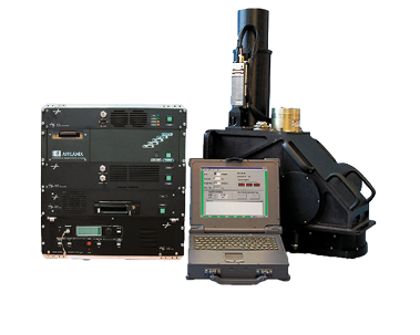
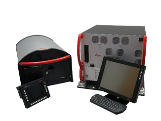
ALS40 components
(1998 – 2003, S/N 001 – 015)
Large aperture scanner
for high-altitude work
Scanner assembly
23.5 x 35.8 x 21.8 inches, 120 lb
60 x 91 x 55 cm, 55 kg
Equipment rack
19.0 x 20.6 x 25.0 inches, 140 lb
48 x 52 x 64 cm, 64 kg
Laptop control computer
Post-processing software
45 kHz max pulse rate
70 Hz max scan rate
In the early years of this century, Leica Geosystems’ lidar guru Ron Roth and LIDAR Magazine managing editor Stewart Walker were both employed by LH Systems and then Leica Geosystems. Stewart decided to renew the acquaintance and find out what’s going on in lidar at Hexagon’s Geosystems Division’s subsidiaries Leica Geosystems and Sigma Space. He visited Leica Geosystems and its Sigma Space operations in Lanham, Maryland on 1 March 2018 and here’s what he discovered. This is the first article: the focus is on linear-mode lidar for both topographic and bathymetric applications, followed by an introduction to single photon. The Sigma Space subsidiary and its single-photon innovations will be described in depth in the second.
Editor’s note: A PDF of this article as it appeared in the magazine is available HERE.
Ron moved to the Lanham facility in 2016. We settled into his office and I noticed the names on the doors of neighboring officers—John Welter (see below), Bruce Wald (see below) and Belai Beshah, another former colleague from LH Systems in San Diego, but now vice president—software development, Hexagon Geospatial Content Solutions (GCS). As ever, Ron was urbane and elegant, but has not abandoned his disconcerting yet endearing habit of diverging into well rendered sketches from Monty Python’s Flying Circus, as well as irrelevant references to classical architecture.
Ron’s job title is Product Manager—Airborne Topographic Lidar for Hexagon’s Geosystems Division’s GCS. As acquisitions are integrated into a large company, managers’ roles are molded and clarified. Ron reports to John Welter, division president, GCS, who arrived by way of the acquisition of Northwest Geomatics, Calgary, Canada, in 2014. Also reporting to John is vice president Anders Ekelund, who came to Hexagon as a result of its acquisition in 2013 of Airborne Hydrography AB (AHAB), Jönkoping, Sweden. The structure enables Anders to focus on business and product development for the bathymetric lidar market. Poul Norgård, chief product officer, joined Geosystems from COWI, a mapping services customer in Denmark. Klaus Neumann, who arrived through Z/I Imaging, Aalen, Germany, part of the acquisition of Intergraph by Hexagon in 2010, is now vice president technical sales and also provides product guidance for imaging. His role in providing technical support to the sales operation will grow and will embrace lidar.
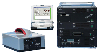
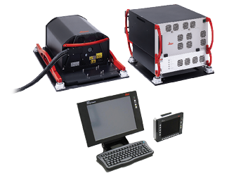
ALS50-I + components
(2003-2006, S/N 016 – 049)
Compact system for installation
on many aircraft types
Scanner assembly
21.2 x 14.4 x 9.8 inches, 80 lb
54 x 37 x 25 cm, 36 kg
Equipment rack
19.0 x 20.6 x 25.0 inches, 140 lb
48 x 52 x 64 cm, 64 kg
Laptop control computer with GUI
Post-processing software
83 kHz max pulse rate
77 Hz max scan rate
Thus, the team is truly international on both the product management and development sides. Ron himself came from Azimuth Corporation, Westford, Massachusetts, which was acquired in 2001 by LH Systems, a joint venture formed in 1997 by Leica Geosystems and the U.S. corporation GDE Systems (now part of BAE Systems).
Azimuth Corporation
Ron’s career began after a BSc degree in mechanical engineering from Worcester Polytechnic Institute in Worcester, Massachusetts, to which he later added an MBA from Babson College, Babson Park, Massachusetts. By the early 1990s, he was working with Doug Flint in Holometrix, Cambridge, Massachusetts. Holometrix won a number of Department of Defense (DoD) Small Business Innovation Research awards in the optical range-finding domain. Indeed, the potential of laser measurement for mapping was well understood and mentioned in the paperwork associated with some of these awards, dating back to the late 1980s. In 1991 Doug, Ron and colleague Bob Eaton took private two parts of Dynatech Scientific—Holometrix’s electro-optics group and an acquisition, Associated Controls and Communications, which was involved in electro-optics and radar technology. Bob had worked for Dynatech Scientific and its predecessor. Doug, Bob and Ron, therefore, shared an electro-optics R&D background that stood them in good stead as the years passed.
Thus the three engineers founded Azimuth Corporation and moved into modest premises in Westford. Ron emphasized that they founded Azimuth to focus on precise optical ranging, not lidar, which became important to them only in 1998. They worked on laser rangers and profilers and initially performed on DoD contracts before developing a commercial airborne lidar product. He remembered affectionately the skills of the Westford group, which developed the first commercial ai
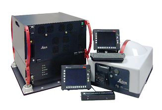
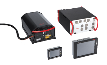
ALS50-II components
(2006-2008, S/N 051 – 105)
Further refinements with
expanded altitude range
Variants: ALS50-II, Corridor Mapper and MPiA
Scanner assembly (L/W/H)
21.2 x 14.4 x 9.8 inches, 80 lb (sm)
25.6 x 16.3 x 9.8 inches, 91 lb (lg)
54 x 37 x 25 cm, 36 kg (sm)
65 x 41 x 25 cm, 41 kg (lg)
Rackless electronics (W/D/H)
17.6 x 24.5 x 14.0 inches, 88 lb
45 x 63 x 36 cm, 40 kg
Operator OC50 with FCMS flight navigation
and separate ALS GUI
Pilot OC50 with FCMS flight navigation
Pilot GI40
Post-processing software
150 kHz max pulse rate
90 Hz max scan rate
rborne lidar product in only nine months. Indeed, there is an ASPRS film that documents the foundations of lidar: watch asprs.org/news/asprs-films/asprs-films-viewer.html.
Every few months Ron received a call, typically from someone in the mapping business, asking if Azimuth could add a scanning mechanism together with GPS and IMU to one of its high-speed, precise optical range-finding systems, but nothing happened
because initial costs were too high. Finally, in 1997, another call came from Photo Science (subsequently EarthData, now part of Fugro), asking Azimuth to develop a high-altitude lidar system to fly with imaging systems acquiring USGS DOQQ images at 6000 m flying height and 75° FOV. Azimuth had already put systems in aircraft, with GPS but no IMU, just an assumption that the system was pointing approximately nadir. The 20-pulses-per-second technology (yes, 20 Hz!) could produce only one point every tens or even hundreds of meters. This was similar to the approach known to photogrammetrists in the early days as airborne profile recorder. Georeferencing was rudimentary, little more than just timing, to estimate where the aircraft was when the laser was fired. At best, they had a vertical gimbal to provide a broad approximation to nadir pointing. Nevertheless, an agreement was reached with Photo Science, and work began.
By August 1998, the components of the system had been gathered and integrated. The team drove to Photo Science’s flight center in Hagerstown, Maryland and installed the prototype in an aircraft. It worked and the first unit was sold in late 1998, followed by two more in 1999. The marketing effort lagged the technology, however—Azimuth had no website and only one e-mail address—but four more units were sold in 2000. Azimuth worked closely with EarthData and other mapping companies, such as Vernon F. Meyer, New Orleans, Louisiana (which became part of 3001, later acquired by Northrop Grumman in 2008), often developing new features with each sale.
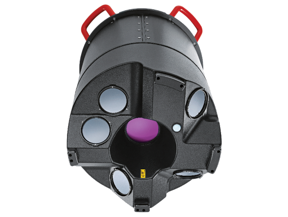
ALS60 components
(2008-2011, S/N 6105-6159+)
More robust design and even
higher productivity
Availability: ALS60, Corridor Mapper, WDM65 Waveform Digitizer Module and MPiA
Scanner assembly (L/W/H)
23.7 x 14.5 x 10.7 inches, 93 lb
60 x 37 x 27 cm, 42 kg
Rackless electronics (W/D/H)
17.6 x 24.5 x 14.0 inches, 99 lb
45 x 62 x 36 cm, 45 kg
Operator OC52/OC50 with FCMS flight
navigation and FCMS ALS Sensor Control (’09)
Pilot OC50 with FCMS flight navigation
Pilot GI40
Post-processing software
200 kHz max pulse rate
100 Hz max scan rate
Meyer had no aircraft and relied on partners with aircraft and sensors to collect data for them. One of these was Northwest Geomatics, so the relationship began with John Welter, who was heavily involved in the technical management of the company’s flying operations and the performance of its sensors. John gave a contact name to Ron—Stewart Walker at LH Systems in San Diego, California, of which Northwest Geomatics was a customer. During the ISPRS Congress in Amsterdam in 2000, at which LH Systems launched the revolutionary ADS40 airborne digital sensor, Stewart called and invited Ron to make a presentation at their next user group meeting. Azimuth was seeking other outlets for its technology—or investors, capital or an exit strategy. A graphic of Azimuth’s AeroScan was doctored to look as if it was in Leica Geosystems green livery with orange trim and renamed “ALS40?”. Azimuth was interested in using LH Systems for marketing, for a finder’s fee, or private labeling, or investment. But Bruce Wald, CEO of LH Systems, perceived a danger: if both companies had to generate their required gross margins on the same product, the resulting price point would be higher than competitors’. The solution was acquisition, completed in April 2001. This was a time of great change: a month later, LH Systems was re-purchased by Leica Geosystems (itself created in 1997 as Leica split into smaller units), which had acquired Cyra Corporation, San Ramon, California in 2000 and ERDAS, Atlanta, Georgia in 2001.
Leica Geosystems set up a GIS & Mapping Division, managed by Bob Morris (now at GeoLearn). Bruce Wald left Leica Geosystems for 15 years, but has returned as chief operating officer, content programs, GCS. Leica Geosystems and Intergraph were acquired by Hexagon in 2005 and 2010 respectively. These tumultuous times resulted in a remarkable product range, of which the ALS-series lidar systems were an important part. Doug Flint eventually left Leica Geosystems. Bob Eaton continued in the company until shortly before his passing in 2015.
ALS-series
ALS70 components (2011-2014, S/N 7160-7234) Dual-output Lidar for increased pulse/scan rates Availability: dual-output scanners ALS70-CM (City Mapper) and ALS70-HP (High Performance); single-output scanner ALS70-HA (High Altitude) Scanner assembly (L/W/H) 23.7 x 14.5 x 10.7 inches, 93 lb 60 x 37 x 27 cm, 42 kg Rackless electronics (W/D/H) 17.6 x 24.5 x
ALS70 components
(2011-2014, S/N 7160-7234)
Dual-output Lidar for increased
pulse/scan rates
Availability: dual-output scanners ALS70-CM (City Mapper) and ALS70-HP (High Performance); single-output scanner ALS70-HA (High Altitude)
Scanner assembly (L/W/H)
23.7 x 14.5 x 10.7 inches, 93 lb
60 x 37 x 27 cm, 42 kg
Rackless electronics (W/D/H)
17.6 x 24.5 x 14.0 inches, 99 lb
45 x 62 x 36 cm, 45 kg
Operator OC52/OC50 with FCMS flight
navigation and FCMS ALS Sensor Control (’09)
Pilot OC50 with FCMS flight navigation
Pilot GI40
Post-processing software
500 kHz max pulse rate (ALS70-CM/ALS70-HP), 200 kHz max pulse rate (ALS70-HA)
200 Hz max scan rate (ALS70-CM/ALS70-HP), 100 Hz max scan rate (ALS70-HA)
User-selectable scan patterns (sine, triangle, raster)
14.0 inches, 99 lb 45 x 62 x 36 cm, 45 kg Operator OC52/OC50 with FCMS flight navigation and FCMS ALS Sensor Control (’09) Pilot OC50 with FCMS flight navigation Pilot GI40 Post-processing software 500 kHz max pulse rate (ALS70-CM/ALS70-HP), 200 kHz max pulse rate (ALS70-HA) 200 Hz max scan rate (ALS70-CM/ALS70-HP), 100 Hz max scan rate (ALS70-HA) User-selectable scan patterns (sine, triangle, raster)
Ron characterized the market-place. Teledyne Optech (at that time it was just Optech, since the Teledyne acquisition did not occur until 2015) was already up and running. RIEGL of Austria was another dangerous competitor, as was Schwarz Electro-Optics in Orlando, Florida. Those were the competitors in optical range-finding, but Optech had the lead in the early and mid 1990s, in what we now know as airborne lidar, with its ALTM 1020.
Azimuth was not taken particularly seriously until the acquisition by LH Systems. Optech had sold about 25 units before Azimuth sold its first. Sensors had also been fielded by RIEGL, often within other suppliers’ systems, since RIEGL tried to make its systems easy to integrate, for example with OEM GNSS/IMU subsystems. Optech’s were more turnkey. The Azimuth unit, however, could operate at greater flying heights than its competitors. Whereas LH Systems had re-sold Applanix GPS/IMU systems and some competitors continue to purchase GNSS/IMU subsystems from OEMs, Leica Geosystems eventually created its own IPAS systems, originally developed by Tim Crago and Dr. Huanqi Sun at Terramatics Technologies in Calgary, which was taken over by Northwest Geomatics. Hexagon also purchased another Calgary GPS system supplier, NovAtel, in 2008 and the remaining employees from the Terramatics Technologies group were moved into the NovAtel facility. Hence, Leica Geosystems lidar sensors currently use NovAtel SPAN GNSS/IMU systems.
Ron fondly recalled the 2000-05 period, when many companies invested in lidar systems and market absorption was high. The competing vendors were pushing as many as 60 units into the market every year, at over $1m each. He assiduously maintained a spreadsheet of sales by each vendor and this has grown over the years into a complete catalog of airborne instrument sales and a valuable internal tool.
There was a dip after the “market perturbations” of 2008, but the volume remains sufficient to sustain the three mainstream competitors, though the level of 60 units per year has not yet been repeated. Ron estimated that 700-800 units have been installed on manned aircraft and helicopters, though much depends on how to account for system upgrades, etc. He monitors unique serial numbers, of which Leica Geosystems has 260 in play, but with upgrades this is equivalent to 500-600 systems manufactured. Ron felt that the market for traditional airborne lidar systems is now saturated to some extent, especially since newer systems are more productive than older, enabling more and more data to be acquired each year without fresh system purchases. Productivity has doubled approximately every two years, a sort of Moore’s law of lidar. Ron uses effective pulse rate rather than points per square meter to gage this and reckons that the course of development consists of jumps interspersed by rests on a plateau. The use of diode-pumped lasers, the introduction of multiple-pulse-in-air (MPiA) technology and multi-optical-channel systems, for example, have been amongst these jumps.
ALS80 components
(2014-, S/N 8235-8247+)
Improved scan geometry, laser
and GNSS/IMU
Availability: dual-output scanners ALS80-CM (City Mapper) and ALS80-HP (High Performance); single-output scanner ALS80-HA (High Altitude)
Scanner assembly (L/W/H)
23.7 x 14.5 x 10.1 inches, 103 lb
60 x 37 x 26 cm, 47 kg
Rackless electronics (W/D/H)
17.6 x 24.5 x 9.5 inches, 72 lb
45 x 62 x 24 cm, 32 kg
Operator OC60 with FlightPro flight navigation and ALS Sensor Control
Pilot PD60 with FlightPro flight navigation
CloudPro post-processing software
1.0 MHz max pulse rate (ALS80-CM/ALS80-HP), 500 kHz max pulse rate (ALS80-HA)
200 Hz max scan rate (ALS80-CM/ALS80-HP),
100 Hz max scan rate (ALS80-HA)
User-selectable scan patterns (sine, triangle, raster)
Airborne Hydrography AB
Ron addressed the AHAB acquisition. The company was founded in 2002 by three Saab employees, to whom Saab had sold the rights to a system. The airborne bathymetric lidar market was a tough one for AHAB to penetrate, as it was predominantly a deep-water one: only one or two systems are sold annually worldwide and the customers tend to be institutional ones such as the U.S. Army Corps of Engineers (USACE).
Optech was by far the largest player. The water penetration of the systems is about three times the Secchi depth, up to 50 m. The Optech SHOALS systems was developed for USACE and, moreover, Optech was in bathymetric lidar before topographic and competed with Saab and the LADS system from Australia. Multi-beam sonar remains the preferred technology for hydrographic charting. Then “shallow-water bathymetry” arrived, with systems offering one times the Secchi depth, perhaps a maximum of 25 m. Leica Geosystems, therefore, perceived the shallow-water market as bigger, since system prices were not so much greater than the topographic ones. Also, in water 30-50 m deep sonar is often feasible, since vessels can often sail safely, and economically, and the swaths are wider at greater depths. Operating in shallow water, on the other hand, is expensive, dangerous or both; if lidar can survey the areas from the shore to waters deep enough for satisfactory sonar operation, then it is a powerful solution. Full waveform digitizing and analysis came with bathymetric systems. Optech, therefore, has been offering this for some time and Riegl has done extensive work on the processing side too, including on-the-fly conversion of waveforms to range data. Leica Geosystems realized that it could bring this full-waveform expertise to its topographic products, as Optech had done earlier.
Sigma Space
At this point, we had covered the first two prongs of Leica Geosystems’ airborne lidar triad, the ALS-series topographic systems, with their origins in the Azimuth strand of the history, and the bathymetric and topobathymetric systems from the Saab/AHAB side. We turned to Sigma Space. Ron provided me with a succinct introduction to the acquisition, the motivation and the technology, then I was privileged to spend time in the afternoon with Sigma Space CEO and founder, Dr. Marcos Sirota. This fascinating story will be unveiled in the second article. Suffice it to say here that commercial products based on single-photon lidar technology are now part of the Leica Geosystems product portfolio, while application-specific developments in single-photon technology continue to be offered through the Sigma Space operation.
Ron stated, however, that the airborne lidar product range is simpler than those of competitors. Chiroptera and HawkEye III are solutions for shallow and deep water respectively. ALS series will soon go out of production after a 20-year run and be superseded by TerrainMapper. No sensor suitable for UAVs is currently offered. TLS/MMS is a separate product area.
Content programs
I was curious about Hexagon’s enthusiasm for content programs, as it is becoming a data supplier as well as a supplier of systems to enable its customers to acquire data. This wouldn’t have happened 20 years ago. Ron felt that the company is attempting to acclimatize the industry to the content-program approach.
There has been some healthy skepticism in the market-place about the Hexagon Imagery Program (HxIP), yet more and more customers want to become partners, because they realize that financial efficiencies are going to drive end-users of data to collaborate on data acquisition. Everyone benefits from a “fly once, use many times” business model. The market seems to have grasped this. The success of content programs, however, is incumbent on the availability of very high-quality, dependable partners. Not everyone has the energy and discipline to generate top quality data.
Ron stated that 3DEP will be a customer—not a competitor. He gave the analog, on the imagery side, of the NAIP program, which consumes imagery that also resides in a content program. In other words, data is acquired and goes to both the government project and the content program. Users purchase data they need from the content program, in a timely fashion, at a lower price, and can do so again in three years. Indeed, Valtus, which was an affiliate of Northwest Geomatics when the latter was acquired by Hexagon already has ALS50-II and ADS lidar data along with imagery. Bruce Wald is COO for the program and I hope to work with him on a future article looking at these programs and the underlying business strategy.
Finally, I asked about multispectral lidar. Ron explained that this simply means multiple lasers in the same lidar system, operating at different wavelengths. The Optech TITAN system, for example, has three wavebands, by using three lasers, which are not co-registered, so the fusion is done in the software. Ron did not commit on whether Leica Geosystems is interested in moving in this direction, though the Chiroptera and HawkEye bathymetric systems are already multispectral, with both green and infrared wavelengths used in the same instrument.
More to come!
In the morning, therefore, I had caught up with Ron Roth and seen the ongoing integration of Sigma Space into Hexagon’s Geosystems Division. I had enjoyed insight into the complexities of the moving parts of the Hexagon organization—firms, people, places and products—and the intriguing history behind some of them. I had secured an afternoon appointment with Marcos Sirota to “get into the weeds” of Sigma Space. That will be written up in the second article.
Sidebar:
Hexagon Linear-mode Today
CityMapper
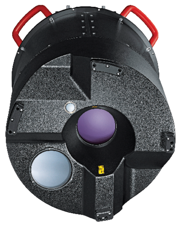
 In the very first meeting between Azimuth Corporation and LH Systems, almost 20 years ago, the concept of very close integration of lidar and image acquisition systems was discussed! Now it has been implemented in a hybrid sensor, Leica CityMapper: the optics for four oblique RCD30 CH81 three-band and one vertical RCD30 CH82 four-band 80-megapixel camera heads can be seen surrounding the bigger optic of the Hyperion lidar (700 kHz maximum pulse rate, 100 Hz maximum scan rate). The circular shape of the housing fits in the Leica PAV100 gyro-stabilized mount. CityMapper is designed for urban mapping. The post-processing workflow includes the Leica HxMap and Leica RealCity software products, which can result in a city model like the one in the background.
TerrainMapper
 Complementing Leica CityMapper is Leica TerrainMapper, designed for large-area acquisitions and combined with Leica HxMap and Leica RealTerrain software. This hybrid sensor features high-performance lidar ((2.0 MHz maximum pulse rate, 150 Hz maximum scan rate) and the option of a vertical RCD30 CH82 four-band 80-megapixel camera head. For easy recall, Ron distinguished between the two hybrid systems in a sentence, “CityMapper is cameras with lidar, TerrainMapper is lidar with a camera.”
Modern Bathymetric Sensors
Chiroptera II
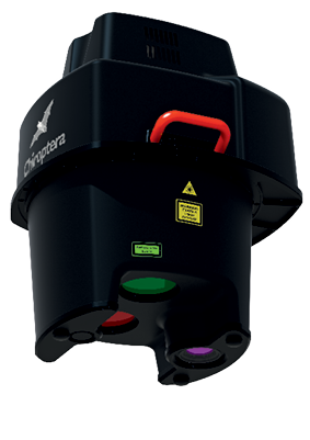 The Leica Chiroptera II is Hexagon’s shallow-water topo-bathymetric lidar for coastal surveying to ~1.5 Secchi depth down to 25 m. It combines a 35 kHz bathymetric channel with a green laser and a 500 kHz topographic channel with an infrared laser. There is a small camera for QA purposes and the option of a vertical RCD30 CH82 four-band 80-megapixel camera head. The software workflow includes Leica Survey Studio.
HawkEye III
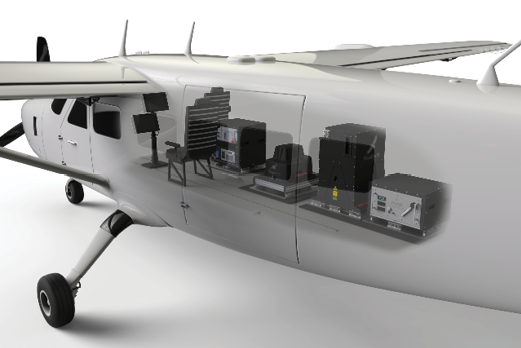
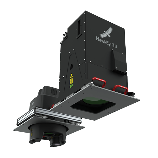 Hexagon’s deep-water bathymetric lidar solution is Leica HawkEye III, with capabilities of ~3.0 Secchi depth down to 50 m. It combines a 10 kHz bathymetric channel for deep water, a 35 kHz bathymetric channel for shallow water down to 2 m depth and a 500 kHz topographic channel. These have green and infrared lasers respectively. The camera and software provisions are similar to Chiroptera II. Indeed, an upgrade from Chiropetra II to HawkEye III is available. The background schematic illustrates a complete system mounted in an aircraft.