Mapping activities for the United States are centrally regulated for a land area of 3.8 million square miles, whereas lidar coverage of Europe’s 3.9 million square miles is managed at the national level, by 50 different countries. This approach has resulted in varying levels of coverage: some areas boast extensive lidar data, while others are still in the early stages of implementation, as explained in the first part of “Elevations for the Nations”1.
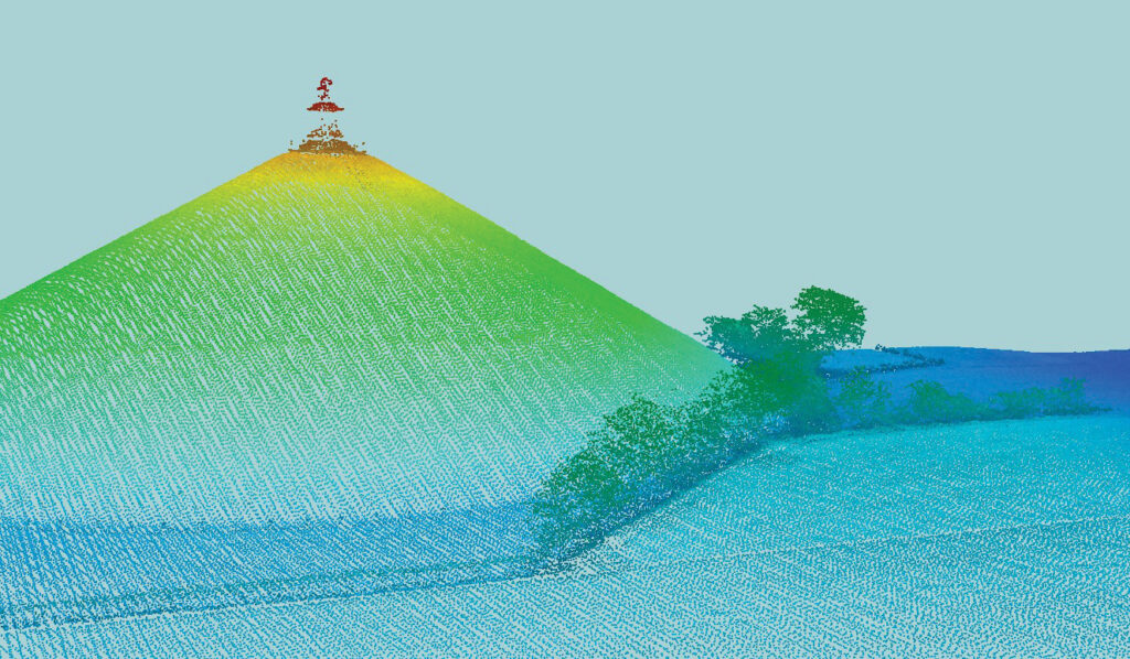
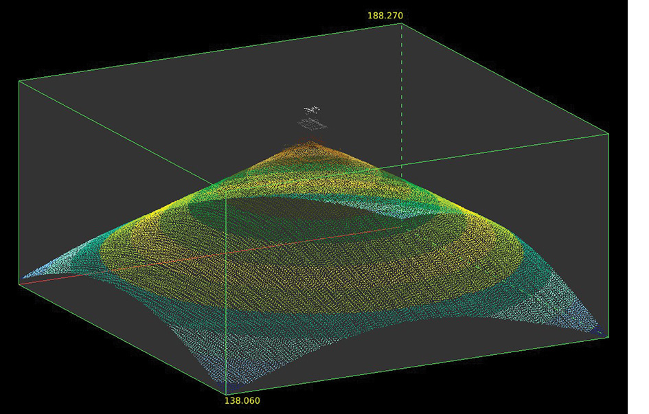
These lidar scans of the Lion’s Mound at Waterloo, Belgium, vividly showcase the monument, which commemorates the Allied victory over Napoleon. Erected between 1823 and 1826, the mound is 40.5 m high with a circumference of 520 m, formed from 300,000 m³ of battlefield soil. The cast-iron lion atop, designed by Van Geel and weighing 28 tonnes, symbolizes restored peace. This digital visualization highlights both historical significance and technological advancement in heritage preservation. Credit: NGI/IGN Belgium.
To gain a comprehensive understanding of lidar mapping across Europe, the European Association of Aerial Surveying Industries (EAASI2) reached out to representatives from national mapping agencies on the continent.
In this second part of our series, we explore the diverse lidar initiatives in Belgium, Poland, Romania, Switzerland, and the United Kingdom. Each country presents a unique case study in the application of lidar technology, reflecting individual priorities and technical capabilities.
Belgium: a regional approach
Belgium’s lidar coverage is characterized by regional initiatives rather than a nationwide endeavor. Each region—Flanders, Wallonia, and Brussels—has taken charge of its own territory’s coverage, showcasing a decentralized approach to geospatial data collection.
Flanders
Flanders conducted its first airborne lidar mission3 from 2001 to 2004, with a density of 0.25 points per square meter (ppsm). This initial effort aimed to facilitate the straightforward classification of ground, non-ground, and water features. Flight strips were flexibly flown based on the layout of the major river basins, ensuring comprehensive coverage of the Flemish region. Interestingly, a few cities were mapped using stereo photogrammetry, deviating from the standard lidar approach.
The second airborne lidar mission4, between 2013 and 2015, significantly increased the density to 16 ppsm and included the Brussels area. These flights took place during winter with a 50% overlap between flight lines, focusing on first returns. The classification process was similar to the first mission, but included additional outlier filtering to improve data quality.
Wallonia
Wallonia’s first airborne lidar5 mission took place from 2013 to 2015, with a point density of 0.8 ppsm. These winter flights, with a 30% overlap, aimed to capture ground points and achieve a 1-meter resolution digital terrain model (DTM). The data was classified into five categories: off-ground, ground, high vegetation, water, and bridges, with a vertical accuracy of 12 cm.
The second mission6, conducted between 2021 and 2022, increased the density to 6.8 ppsm. These flights had a 60% overlap and aimed to achieve a 0.5-meter resolution DTM. The data classification expanded to seven categories, adding non-classified and high-voltage lines to the previous categories.
Brussels
Brussels carried out its first lidar mission7 in April 2012, achieving a point density of approximately 30 ppsm. This mission aimed to generate a DTM and a building model at Level of Detail 2 (LoD 2). The second mission8, in October 2021, further increased the density to about 67 ppsm, focusing on 3D modeling and potentially creating a digital twin of the city.
Innovative applications of lidar technology in Belgium include 3D building modeling using point clouds and exploration of the integration of artificial intelligence (AI) in lidar data analysis. While the current focus remains on derived products such as DTMs and digital surface models (DSMs), the future holds exciting possibilities for AI-driven insights.
Poland: a comprehensive national resource
In Poland, the Head Office of Geodesy and Cartography (GUGIK9) maintains the National Geodetic and Cartographic Resource (NGCR), which includes comprehensive lidar data. The Geodetic and Cartographic Law places the responsibility for maintaining this resource squarely on GUGIK’s shoulders, ensuring a unified national approach.
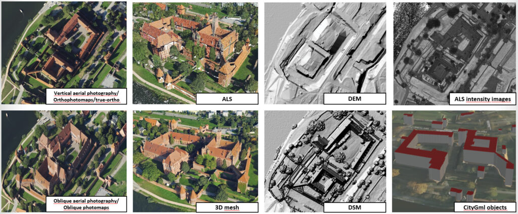
NGCR of Poland houses a comprehensive collection of geospatial data, encompassing vertical and oblique aerial imagery, orthophoto maps, lidar-derived products such as DEMs and intensity images, and advanced 3D models. Credit: National Geodetic and Cartographic Resource (NGCR).
NGCR boasts a wealth of critical datasets, including vertical aerial imagery, orthophoto maps, true orthos, airborne laser scanning (ALS), digital elevation models (DEMs), ALS intensity images, oblique aerial photography, oblique photomaps, 3D mesh, and DSMs. Notably, the ALS data envelops the entire country, with urban areas receiving updates every two years.
In the years 2024-2026, GUGIK plans to acquire photogrammetric data in accordance with the three standards set out in the table above:
- high-resolution photogrammetric data for urban areas (“high resolution”)
- high-resolution photogrammetric data for urban areas (“high resolution—full set”)
- photogrammetric data for non-urban areas (“standard”)
Poland is adopting two standards for lidar data collection: a minimum of 12 ppsm for urban areas (2-year cycle) and 4 ppsm for rural areas (5/6 year cycle). This balanced approach ensures high-quality data acquisition while meeting diverse needs across different landscapes and settings.
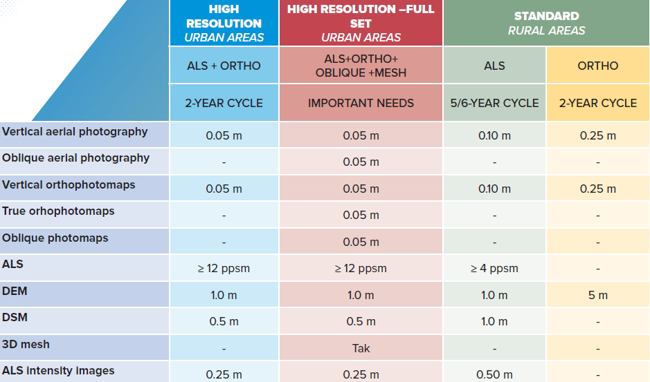
Standards for planned photogrammetric data collections in Poland. The plans are published via www.geoportal.gov.pl in the layer group “Data acquisition status”.
Lidar data, particularly ALS data, forms the foundation for many other crucial registers in Poland, making it a cornerstone of the country’s geospatial infrastructure. Its applications are wide-ranging, playing a critical role in:
- Security and crisis management through the creation of risk and flood hazard maps
- Spatial management and urban planning
- Hydraulic modeling and environmental protection
- Forestry management
- Administration for analysis and decision-making
- Scientific research and archaeology
- Tourism development
GUGIK has ambitious plans for extensive data acquisition from 2024 to 2026, targeting high-resolution data for urban and rural areas. The agency continues to pioneer innovative lidar applications, delivering hybrid solutions that integrate aerial photography and elevation data to meet rigorous standards and address a wide array of user needs.
Poland’s commitment to open data is evident in its approach to lidar dissemination. A significant portion of the geospatial data collected in the NGCR, including ALS data, is openly accessible and freely downloadable via www.geoportal.gov.pl. This initiative underscores Poland’s dedication to advancing geospatial data accessibility and utility, setting a notable example for other European nations.
Romania: balancing security and innovation
Romania’s approach to lidar coverage reflects a balance between security considerations and technological innovation. The National Center of Cartography10 (CNC) primarily focuses on quality control, while data acquisition responsibilities rest with the National Agency of Cadaster and Land Registration (ANCPI) and its data producers.
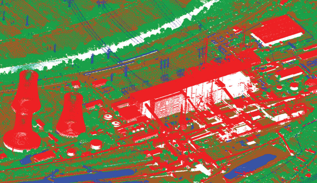
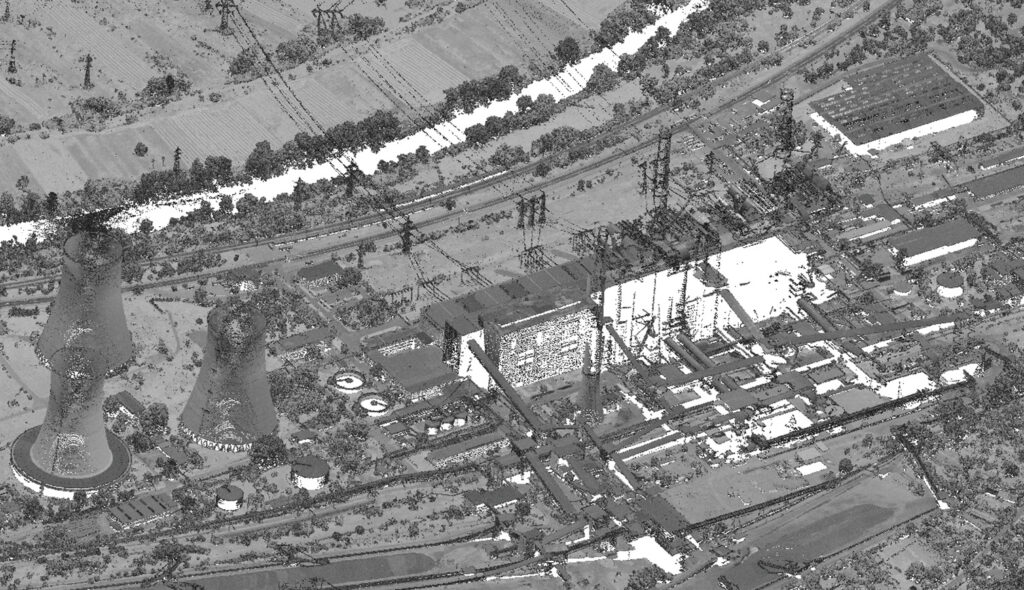
These lidar point clouds capture Rovinari power station, one of Romania’s largest electricity producers, located in Gorj County near Târgu Jiu on the Jiu River. Credit: National Center of Cartography of Romania (CNC).
Lidar data collection in Romania is influenced by legal parameters, particularly a law stipulating that anything exceeding 9 ppsm must undergo a rigorous declassification process. According to Law 182/2002, modified by Law 167/2015, “… aerial photogrammetric recordings obtained with airborne sensors of any type operating in the electromagnetic spectrum, with spatial resolution smaller than 15 cm, and aerial photogrammetric recordings obtained with active digital airborne sensors containing more than 9 points/m2, representing content elements relevant to national security, are considered state secrets.”
Due to these complexities, Romanian institutions often opt for lower densities. For example, the LAKI II project, completed in 2022, used 8 ppsm, while the ongoing LAKI III project (part of the Land Administration Knowledge Improvement initiative) uses 5 ppsm.
Despite these challenges, Romania is actively engaged in innovative applications of lidar technology through European projects. Two notable examples are:
- The CARMINE11 (Climate-Resilient Development Pathways in Metropolitan Regions of Europe) project: This initiative aims to aid local adaptation strategies by providing decision support services and fostering multi-level climate governance. Romania’s involvement includes creating a DTM for the metropolitan region of Brasov city, one of the project’s case study areas.
- The Volta12 project: As part of this Marie Slodowska-Curie RISE action, Romania is involved in developing and validating novel processing methods for 3D geospatial data to enhance photogrammetric mapping applications. The country recently submitted another project proposal, called i-DEAL, to the European Commission, showcasing its commitment to cutting-edge research.
On the services front, Romania is prioritizing aerial photogrammetry projects, aiming to create a comprehensive catalogue of housing units listed in the cadastre. The country’s geoportal hosts a variety of datasets, including aerial images and digital terrain models. While challenges persist in achieving full national lidar coverage, interested parties, such as museums and academia, can request specific point clouds for research purposes.
Switzerland: a pioneer in national coverage
Switzerland has been at the forefront of lidar technology adoption, with swisstopo13, the national mapping agency, initiating its lidar journey in the early 2000s with the production of the cadastral survey DTM (DTM-AV), a precursor to the swissALTI3D.
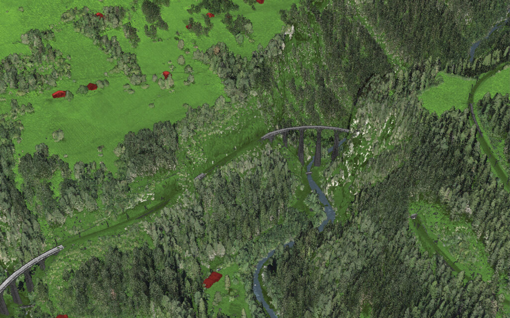
The Landwasser Viaduct, a six-arched curved limestone railway bridge, spans the Landwasser River between Schmitten and Filisur in Graubünden, Switzerland. Designed by Alexander Acatos and built by Müller & Zeerleder in 1901-02, it is a key structure of the World Heritage-listed Albula Railway. Owned by the Rhaetian Railway, the viaduct stands 65 m high and 136 m long. Its southeastern abutment connects to the Landwasser Tunnel. Credit: swisstopo.
In 2017, swisstopo, in cooperation with the cantons, launched a new acquisition campaign to obtain lidar data for the whole of Switzerland and Liechtenstein, spread over six years. This campaign will be concluded with the publication of the data by the end of 2024.
Switzerland is currently undergoing its second complete national lidar coverage, with plans already underway for a third acquisition phase. Annually, approximately one sixth of Switzerland’s expansive territory, accounting for around 7000 km², is acquired in lidar.
Swisstopo has selected an average point density of 20 ppsm for lidar data collection. The data undergoes classification into various categories, encompassing unassigned, ground, vegetation, buildings, bridges, facades, wire cables, water, and noise. The decision-making process for this density considers factors such as acquisition costs, long-term data archiving, and the limited acquisition period per year, ensuring data quality during seasons with minimal foliage and snow.
The collected lidar data is instrumental in updating swisstopo’s swissSURFACE3D product. Derived from airborne lidar, this dataset comprises millions of points per square kilometer, offering a rich 3D representation of Switzerland’s diverse landscape. The data characteristics include a minimum point density of 5 ppsm, with an average density ranging from 15 to 20 ppsm.
Switzerland has embraced innovative applications of lidar technology to enhance its 3D landscape modeling and ground coverage accuracy. One of the exceptional innovations involves the integration of artificial intelligence (AI) with lidar data to facilitate change detection in 3D landscape models.
Switzerland’s approach demonstrates a commitment to high-quality, comprehensive lidar coverage. The country’s mountainous terrain presents unique challenges for data acquisition, but also showcases the versatility of airborne lidar technology in capturing complex topographies.
United Kingdom: a devolved approach
Lidar coverage in the United Kingdom reflects its devolved administration system, with each nation—England, Northern Ireland, Scotland, and Wales—managing its own lidar programs. This approach has resulted in varied coverage and accessibility across the UK, primarily driven by environmental aspects such as flood risk mapping, coastal change, and habitat monitoring.
England
The Environment Agency has been at the forefront of lidar data collection in England since 1998. In 2015, the agency made a landmark decision to make its lidar data freely accessible to the public, empowering various sectors from forestry management to archaeological exploration and virtual reality development for gaming.
The Environment Agency National Lidar Programme14 aims to deliver precise elevation data with 1-meter spatial resolution across all of England. In 2017, the agency divided England into 302 survey blocks for lidar data capture, a task carried out during the winter months from November to April. These initial surveys, known as Phase 1 of the national lidar programme, were conducted between January 2017 and February 2023.
To maintain up-to-date elevation data, the Agency has initiated repeat surveys of specific blocks based on ongoing needs. Each subsequent survey of a block is assigned a new phase number. Currently, there is no plan to systematically re-survey all the original Phase 1 blocks; repeat surveys are instead prioritized according to the necessity for updated data in certain areas.
The collected lidar data is published quarterly via the DEFRA Data Services survey portal. Various products derived from these surveys are made available in 5 km tiles aligned with the Ordnance Survey grid, ensuring users have access to the most recent and accurate elevation data.
Scotland
Lidar data for Scotland is mainly provided by the Scottish Government via the Scottish Remote Sensing Portal15. This portal, developed in partnership with the Joint Nature Conservation Committee (JNCC), offers extensive lidar datasets for public use.
Scotland’s lidar datasets have been developed through several phases, each responding to specific needs:
- Phase I (2011-2012) covered 11,845 km² across 10 sites, aiding in flood management, archaeology, and orienteering. The point density was a minimum of 1 point/sqm, and approximately 2 ppsm on average between the collection areas.
- Phase II (2012-2014) extended coverage to 66 additional sites totaling 3516 km². The point density was a minimum of 1 ppsm, and approximately 2 ppsm on average between the 66 sites.
- Phases III to VI (2015-2022) captured extensive areas but still lack full national coverage. These phases have progressively increased coverage and data quality.
In addition, specific lidar datasets have been captured for Historic Environment Scotland, focusing on areas of historical significance such as Stirling, Edinburgh Old Town and New Town, and the heart of Neolithic Orkney.
Northern Ireland
Lidar data for Northern Ireland is accessible through OpenDataNI16, the region’s Open Data Portal. Published primarily by Land & Property Services (LPS), a branch of the Department of Finance, the available lidar datasets emphasize coverage of river basins. This data supports various applications, including flood risk management, environmental monitoring, and urban planning.
A national survey commissioned in 2022, targeting a high-resolution, 16 ppsm point density, is currently in progress.
Wales
Lidar data for Wales is provided by Natural Resources Wales and can be accessed via DataMapWales17. This platform facilitates the use of lidar data for various applications such as environmental management, urban planning, and flood risk assessment, ensuring that detailed geospatial information is readily available to support a range of public and private sector initiatives across Wales.
A national survey commissioned by the Welsh government was conducted between 2020 and 2024, which captured data at 2-4 ppsm. The resulting data is available as 2-meter gridded DTMs and DSMs under an Open Government License (OGL).
The UK’s devolved approach to lidar coverage reflects the unique needs and priorities of each nation while still contributing to a rich tapestry of geospatial data across the country. This decentralized model allows for tailored solutions but also presents challenges in terms of data consistency and cross-border applications.
Conclusions
Europe’s approach to lidar mapping showcases the continent’s diversity in governance, technological adoption, and environmental priorities. From Belgium’s regional initiatives to Switzerland’s comprehensive national coverage, each country has tailored its lidar strategy to meet specific needs and overcome unique challenges.
The varied approaches highlight the potential for knowledge sharing and collaboration across borders. While a pan-European lidar dataset remains a complex goal due to differing projection systems and data standards, the ongoing efforts in each country contribute to a rich tapestry of geospatial information.
As lidar technology continues to evolve, European countries are finding innovative applications in climate resilience, urban planning, environmental protection, and more. The commitment to high-quality data acquisition and accessibility demonstrates the growing recognition of lidar’s value in addressing critical challenges and driving informed decision-making.
The future of lidar mapping in Europe looks promising, with countries such as Poland and Switzerland already planning next-generation surveys. As the technology advances and cross-border cooperation increases, we may see more harmonized approaches emerging, potentially paving the way for a more unified European geospatial landscape.
For the geospatial industry, particularly aerial surveying companies, these diverse national initiatives present both challenges and opportunities. Adapting to varied specifications and requirements across countries demands flexibility and expertise. However, it also opens doors for innovation in data acquisition, processing, and application development.
As Europe continues to refine its approach to lidar mapping, the continent stands as a living laboratory for geospatial technologies, offering valuable lessons for the global community in balancing national needs with technological advancements. The ongoing dialogue between national mapping agencies, industry stakeholders, and research institutions will be crucial in shaping the future of lidar technology and its applications across Europe and beyond. 
Acknowledgments
The author is grateful for help in creating this article received from: Valéry Lemaire—Institut géographique national (), Belgium; Anna Bober—Head Office of Geodesy and Cartography () Poland; Iuliana Maria Pârvu— (CNC), Romania; Roberto Artuso—Swiss Federal Office of Topography (); and Chris O’Dwyer—Environment Agency, UK.
 Ada Perello is Communications Manager of EAASI. She has a background in marketing, media and communications and is based in Madrid, Spain. She holds a master’s degree in communication and media studies from the University of Valencia and an MBA from the CECO Centre of Studies for Economy and Trade. Her experience includes positions at the Spanish embassy in Tokyo, Japan, the FAO in Rome, Italy and the International Maritime Organisation in London, England.
- 1 Perello, A., 2023. Elevations for the nations: understanding Europe’s varied approach to lidar mapping, LIDAR Magazine, 13(3): 41-45, Fall 2023. lidarmag.com/2023/10/07/elevations-for-the-nations/
- 2 eaasi.eu
- 3 vlaanderen.be/digitaal-vlaanderen/onze-oplossingen/earth-observation-data-science-eodas/het-digitaal-hoogtemodel/dhmv-i-brondata
- 4 vlaanderen.be/digitaal-vlaanderen/onze-oplossingen/basiskaart-vlaanderen-grb/dhmv-ii-brondata
- 5 geoportail.wallonie.be/catalogue/cd7578ef-c726-46cb-a29e-a90b3d4cd368.html
- 6 geoportail.wallonie.be/catalogue/ab14b035-c9b0-4c79-a2b6-36811fca96a1.html
- 7 datastore.brussels/web/data/dataset/5cc11161-6a53-11ed-89a4-010101010000
- 8 datastore.brussels/web/data/dataset/ff1124e1-424e-11ee-b156-00090ffe0001
- 9 gov.pl/web/gugik-en
- 10 cartografie.ro/index.php/ro/
- 11 cordis.europa.eu/project/id/101137851
- 12 cordis.europa.eu/project/id/734687
- 13 swisstopo.admin.ch/en
- 14 data.gov.uk/dataset/f0db0249-f17b-4036-9e65-309148c97ce4/national-lidar-programme
- 15 remotesensingdata.gov.scot/about
- 16 opendatani.gov.uk/
- 17 datamap.gov.wales/maps/lidar-viewer/