
The first step towards a pan-European lidar elevation dataset
A continent rich in data, yet hard to navigate
Europe is rich in lidar point-cloud data, but finding it is surprisingly hard. National, regional, city, and research initiatives alike have produced detailed elevation datasets at varying spatial scales, resulting in a fragmented catalogue of independently maintained point clouds. Studies from Kakoulaki et al. (2021) for the Joint Research Centre, Perello (2023, 2024, 2025) in this magazine, and most recently van der Heide et al. (2026) have all documented this richness and the challenge of building a harmonised pan-European dataset.
Despite this abundance, the point cloud datasets remain fragmented. Each country, region, city or scientific initiative maintains its own data portal, with varying access policies, formats, and metadata standards. Together, the review studies by Kakoulaki, Perello, and van der Heide point to a shared conclusion: a seamless, pan-European lidar-based elevation model remains missing, even though the data is abundantly available.
The discoverability challenge in European lidar data
Arguably, the primary barrier to a pan-European lidar dataset is the data’s discoverability. European point-cloud datasets are distributed across dozens of independent portals, each with its own interface, language, documentation style, data formats, download mechanisms, and licenses.
For point-cloud users, this means that discovering relevant datasets is often time-consuming. Even when the point cloud is found, understanding its specifications requires navigating unfamiliar metadata structures or translating different documentation. Even a simple question, such as the spatial distribution of lidar point clouds in Europe, is challenging to answer. Unlike the United States, where platforms such as OpenTopography provide centralized access to a wide range of datasets, Europe lacks a unified interactive entry point.
Alternatives such as the Copernicus EU-DEM, NASA-DEM, and ALOS World 3D are available for cross-border use, but their resolutions cap at 30 m, which is sufficient for continental models but inadequate for the infrastructure and housing challenges Europe faces. Figure 1 illustrates examples of each available open elevation dataset, comparing the national lidar-based dataset in the Netherlands (top left) with ALOS World 3D (top right), EU-DEM (lower left), and NASA-DEM (lower right).
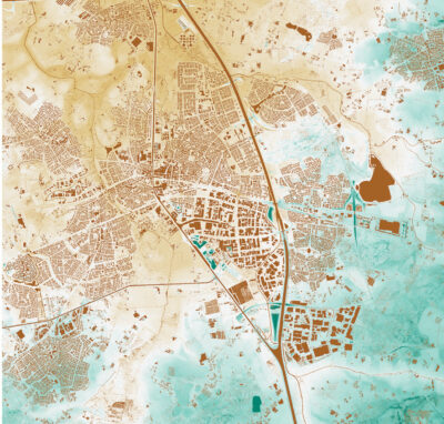
Figure 1: Snapshot of the city of Helmond, Netherlands from various publicly available elevation datasets: Actueel Hoogtebestand Nederland DTM, grid size 5 m (top); ALOS World 3D, grid size 30 m (2nd); EU-DEM, grid size 30 m (3rd; NASA-DEM, grid size 30 m (bottom).
Introducing the European Point Cloud Portal
To address the challenge of discoverability in pan-European lidar datasets, we created the European Point Cloud Portal (Figure 2). This was developed as an open, interactive gateway for discovering lidar datasets across Europe and is a continuation of the EuroSDR1 work (van der Heide et al., 2026). It is hosted by the 3D Geoinformation research group of Delft University of Technology to ensure the platform’s long-term sustainability.
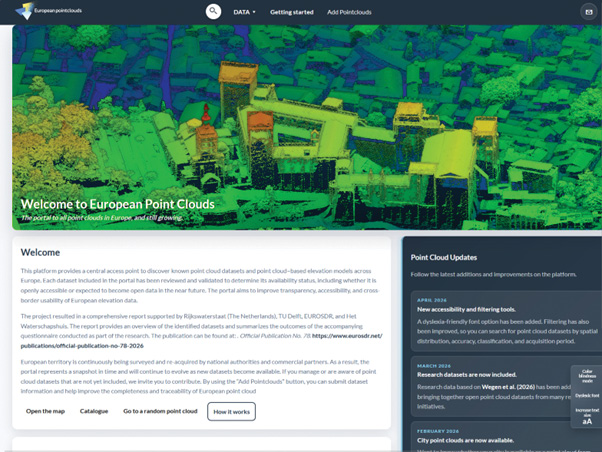
Figure 2: Homepage of the European Point Cloud Portal.
In contrast to platforms such as OpenTopography, the European Point Cloud Portal does not aim to host the datasets centrally; rather, it takes a federated approach, where data remains at its local source while the portal guides users interactively to the relevant data sites. This federated approach aligns with European data governance principles, such as those promoted by INSPIRE (Infrastructure for Spatial Information in Europe) and the GreenData4All initiative of the European Union, both focused on enabling interoperability between national datasets while keeping data at the source.
The European Point Cloud Portal catalogs datasets from a wide range of open providers, including national mapping agencies (e.g., annual ALS campaigns), regional authorities (e.g., provinces, states, or Bundesländer), municipalities (e.g., city-scale acquisitions), and scientific initiatives. At present 134 point clouds or elevation models based on point clouds are discoverable via the portal. All have different scopes, specifications, and acquisition platforms, providing a diverse range of datasets that can be interactively filtered in the portal to quickly access the desired data (Figure 3).
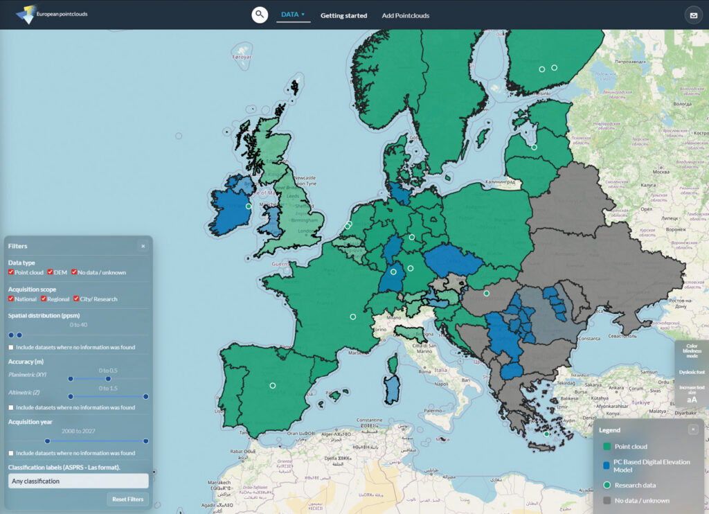
Figure 3: Example of different datasets and filters available in the portal.
Understanding the European Point Cloud dialects
In the context of a pan-European dataset, variations between point clouds affect how datasets can be used, compared, and combined. These were formalized in the EuroSDR study by treating them as European dialects. Based on a questionnaire administered to members of the EuroSDR and municipalities in the Netherlands, the so-called dialects were categorized into four primary groups (Figure 4): (1) spatial distribution, (2) accuracy, (3) classification, and (4) coordinate reference system.
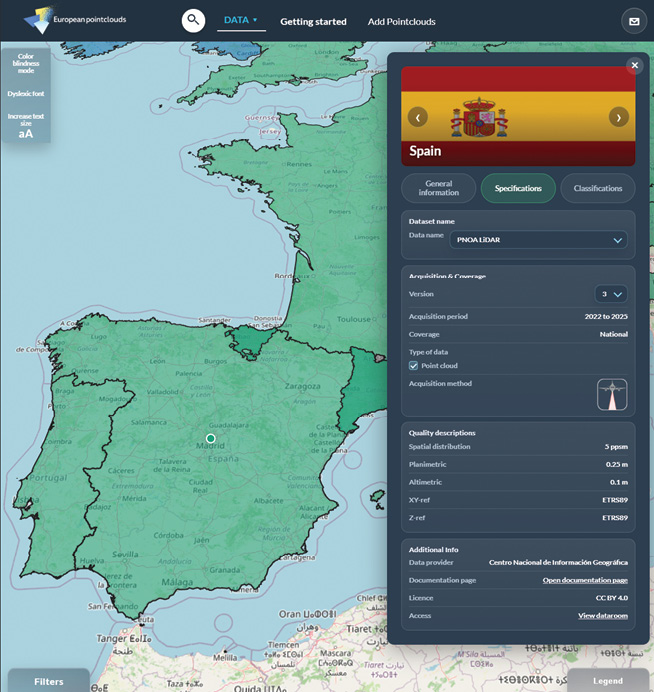
Figure 4: Overview of all the metadata, including the acquisition, coverage, quality and the link to the site of the Spanish point cloud dataset PNOA.
The spatial distribution is often described in 2D point density, e.g., points per square meter (ppsm). Only a few datasets address the three-dimensional aspect of spatial distribution in point clouds, for instance connecting the distance between the points to the point density. The trend in Europe is that national datasets range from 5.5 to 14 ppsm, with a distinct difference between urban and non-urban areas. Focused city or research datasets have far denser spatial distributions, often due to the acquisition method.
The second category, the accuracy levels, is often divided into absolute (e.g., how well the point cloud is placed with respect to the real environment) and relative (e.g., how well the points are distributed within a single acquisition). The values at both levels depend heavily on acquisition methods, sensor quality, and processing workflows.
The third category is the presence of classification labels in point cloud datasets, where the availability and manner of classification guide the selection of the dataset. However, classification schemes are not (yet) standardized across Europe. So, from the perspective of a pan-European dataset, harmonizing cross-border datasets with classification but varying definitions can impose a challenge. Hence, the portal includes dataset classification, as defined by the Open Geospatial Consortium LAS Specification 1.4, rather than the USGS LAS definition table. Thus the user can quickly see the definitions and, for example, what a dataset classifies as low, medium, or high vegetation.
Perhaps the most visible and technically challenging category is the coordinate reference system. European datasets use a wide variety of planimetric and altimetric reference systems. In total, 51 different planimetric and altimetric coordinate systems are used, with 11 countries using the UTM reference system and 16 countries using horizontal systems closely linked to ETRS89. Notably, this point-cloud dialect becomes apparent as no two datasets share the same elevation reference system.
Paving the road to a Pan-European dataset
The European Point Cloud Portal is a step toward an open European dataset comparable with the EU-DEM. By introducing the concept of point-cloud dialects and providing a structured, interactive platform for dataset discovery, it gives anyone working with lidar data across Europe a practical starting point for finding and comparing the right dataset. The portal is growing, and the path toward a seamless, pan-European point cloud dataset is becoming clearer. 
Please let us know whether your open point cloud datasets should be included in the European point cloud portal at europeanpointclouds.tudelft.nl.
Sources
- Kakoulaki, G., A. Martinez and P. Florio, 2021. Non-commercial Light Detection and Ranging (LiDAR) data in Europe, JRC Technical Report EUR 30817 EN, Publications Office of the European Union, Luxembourg, 29 pp. doi:10.2760/212427
- Perello, A., 2023. Elevations for the nations: Understanding Europe’s varied approach to lidar mapping, LIDAR Magazine, 13(3): 41-45. Retrieved from https://lidarmag.com/2023/10/07/elevations-for-the-nations/
- Perello, A., 2024. Elevations for the nations part II: Understanding Europe’s varied approach to lidar mapping, LIDAR Magazine, 14(3): 40-48. Retrieved from https://lidarmag.com/2024/09/22/elevations-for-the-nations-part-ii/
- Perello, A., 2025. Elevations for the nations part III: Understanding Europe’s varied approach to lidar mapping, LIDAR Magazine, 15(3): 36-43. Retrieved from https://lidarmag.com/2025/08/30/elevations-for-the-nations-part-iii/
- van der Heide, D., J. Stoter, T. Eikelboom and J. Leusink, 2026. Point Cloud Dialects in Europe: Review of Point Cloud Datasets and their Quality Descriptors in Europe —- Towards Greater Uniformity, EuroSDR Official Publication No. 78, 72 pp. Retrieved from https://www.eurosdr.net/publications/official-publication-no-78-2026