
Mapping activities for the United States are centrally regulated for a land area of 3.8 million square miles, whereas lidar coverage of Europe’s 3.9 million square miles is managed through a complex patchwork of governance levels—sometimes nationally, sometimes regionally, and occasionally at even more localized levels.
The European Union still does not regulate mapping activities at the supranational level; instead, this responsibility is distributed across various administrative levels within and below Member States. Consequently, lidar coverage across Europe varies not only between countries but also within them, leading to fascinating variations and distinctive characteristics that reflect different political structures and administrative traditions.

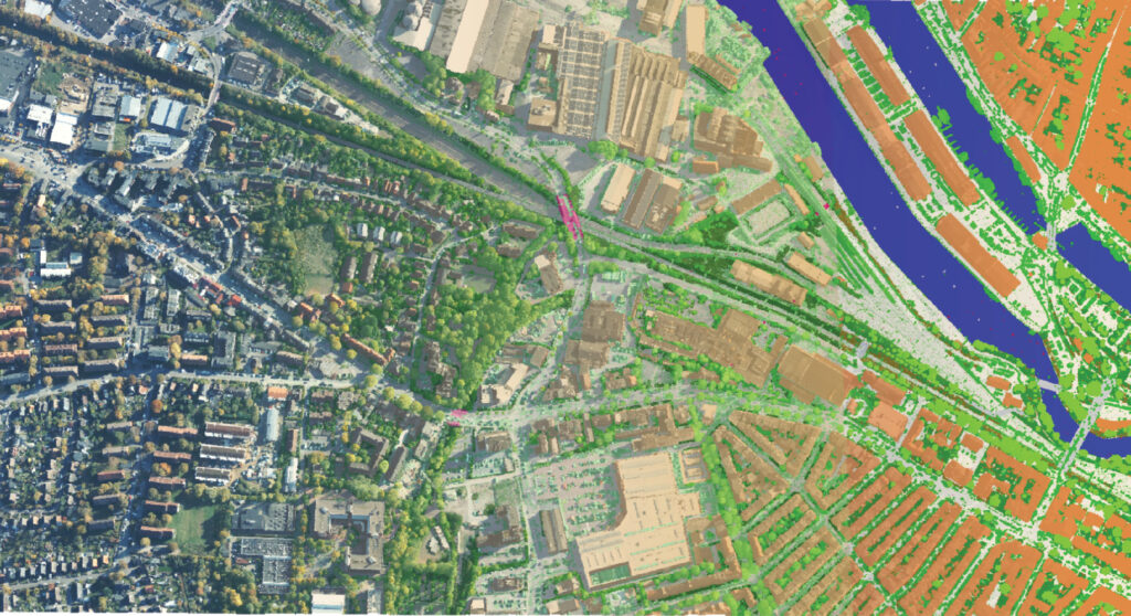
Classified RGB-colored lidar point cloud of Lübeck, Germany. This type of high-resolution 3D data, showing buildings, vegetation, and infrastructure, forms the basis for Germany’s nationwide Digital Twin project. The initiative, coordinated by the Federal Agency for Cartography and Geodesy (BKG), aims to deliver a consistent, classified lidar dataset to support environmental management, urban planning, and infrastructure monitoring across the entire country.
This fragmented approach has created a complex panorama where some areas boast extensive, cutting-edge lidar datasets, while others remain in the early stages of implementation. Access to funding often proves crucial, as many public agencies responsible for lidar coverage lack dedicated budgets and instead rely on commissions from other public organizations for specific projects—such as flood risk assessment or forest monitoring.
Building on previous installments that explored lidar progress in Denmark, Finland, France, the Netherlands, Portugal, Spain (Elevations for the Nations)1; and Belgium, Poland, Romania, Switzerland, and the United Kingdom (Elevations for the Nations II)2, the European Association of Aerial Surveying Industries (EAASI)3 continues its survey of national mapping agencies across the continent. This third part examines the current state of lidar mapping in Austria, Croatia, Germany, Greece, and Italy—five countries that illustrate both the challenges and remarkable achievements emerging within Europe’s diverse geospatial landscape.
Austria: from regional response to national coordination
Austria has a long-standing tradition of using airborne laser scanning (ALS) for public administration, environmental monitoring, and scientific research. For many years, however, lidar coverage developed through regionally driven initiatives. Each of the country’s nine provinces (Bundesländer) carried out ALS campaigns based on their specific needs, technical capabilities, and available funding. While this decentralized approach yielded important datasets—especially in flood-prone and alpine regions—it lacked uniform standards or national coordination.
The adoption of ALS accelerated in the early 2000s, particularly following the catastrophic flooding in 2002, which exposed the need for more accurate terrain data to support hydrological and risk-management planning. In response, several Austrian provinces initiated their own lidar programmes. Between 2005 and 2010, repeated ALS acquisitions were conducted in specific regions, often triggered by natural events such as the 2005 floods. The province of Vorarlberg, for example, developed a recurring lidar dataset to monitor river dynamics and assess geomorphic changes caused by flooding.
In the 2010s, projects like ENVICHANGE integrated ALS data with satellite imagery for multi-temporal environmental monitoring. These initiatives focused on mountainous regions, particularly in the western part of the country, where lidar helped detect rockfall hazards, monitor forest boundaries, and assess the condition of protective infrastructure. These regional efforts created a solid foundation for what has now become a more structured and nationally coordinated system.
Today, Austria is steadily progressing toward full national lidar coverage, supported by a strong partnership between federal and provincial authorities. Data acquisition is now carried out for approximately 55 percent of Austria’s territory by the Federal Office of Metrology and Surveying (BEV)4, with access to this data secured for the provinces by cooperation. While data collection continues to follow regionally agreed priorities, national coordination has significantly improved, leading to more standardized data products across the country.
BEV plays a central role in this process, offering a unified national digital terrain model (DTM) derived from ALS data at a 1-meter resolution, along with a 1-meter resolution digital surface model (DSM). Both datasets are produced in close collaboration with the provinces. For broader-scale applications, a 10-meter DTM is also available. However, this coarser model is not derived from ALS data but from stereoscopic analysis of aerial images. This method, which covered small parts of Austria each year, is being phased out in 2025. The dataset will remain available, but no further updates will be made.
Austria’s geospatial infrastructure is further strengthened by a well-established aerial image acquisition programme. Since 2010, the entire country has been photographed every three years using digital large-format cameras that capture RGB and near-infrared (NIR) bands. These aerial images support the production of orthoimages at a 20-cm ground sampling distance and contribute to the creation of DSMs. While historical aerial imagery dating back to 1949 is maintained in BEV’s archives, the number of analogue images no longer increases, as all current data collection has transitioned to digital platforms. The 0.5-meter DSM, produced through automatic image matching from aerial photographs, will continue to be updated regularly.
A key advancement in Austria’s geospatial framework is the establishment of a common minimum standard for ALS point density. In recent years, the minimum standard has been set at eight points per square meter (ppsm), ensuring high-quality data suitable for a wide range of applications. In some specialized research areas or pilot projects, point densities have reached as high as 15-24 ppsm.
Complementing the elevation models, BEV released a national land cover dataset in 2024 with a spatial resolution of 20 cm. The dataset classifies Austria’s landscape into six categories, including vegetation (low, medium, and high), buildings, soil, and water bodies. Designed for broad public use, this product supports environmental monitoring, urban planning, and land management activities across the country.
Austria’s shift from fragmented regional initiatives to a coordinated national geospatial strategy demonstrates the power of collaboration between federal agencies and provincial partners. With high-resolution ALS data now widely available, streamlined coordination in place, and future acquisitions driven by shared priorities, Austria is well-positioned to support environmental resilience, smart infrastructure planning, and advanced geospatial analysis.
Croatia: European leadership in national coverage
In just a few years, Croatia has positioned itself as a European leader in lidar data acquisition, accessibility, and application. Between 2022 and 2023, the country successfully completed a nationwide airborne lidar campaign covering its entire territory. Simultaneously, high-resolution corridor surveys were conducted along 3501 kilometers of riverbanks, targeting areas of particular relevance for hydrology, flood risk, and environmental management.


Aerial view of Dubrovnik, Croatia, one of many European cities benefiting from high-resolution lidar data for urban planning and heritage conservation. The EAASI Summit 2025 will take place here (18-21 November 2025), gathering aerial surveying leaders from across Europe.
The scale and technical quality of Croatia’s recent efforts place it among Europe’s frontrunners. The lidar survey was meticulously planned according to international standards for large-scale and national mapping projects. Original specifications called for minimum point densities of 4 ppsm in non-urban areas, 8 ppsm in urban environments, and 20 ppsm along river corridors. The final results far exceeded expectations: the national average reached over 15 ppsm across the entire territory, while river corridor areas achieved densities exceeding 40 ppsm. These figures represent one of the highest standardized lidar datasets available in Europe today.


Lidar point cloud visualization of Dubrovnik’s historic Old Town, Croatia, showcasing the detailed three-dimensional mapping capabilities achieved through the country’s nationwide campaign, which was completed in 2023. The color-coded data reveals building structures (orange), vegetation (green), and water surfaces (blue) with exceptional clarity. Croatia’s ambitious lidar program achieved point densities exceeding 15 ppsm nationally, with some areas reaching over 40 ppsm—making it one of Europe’s most detailed national datasets and demonstrating how advanced lidar technology can capture both cultural heritage sites and natural landscapes with unprecedented precision.
Equally notable is Croatia’s open data policy. In accordance with national regulations promoting transparency and innovation, all lidar products are freely accessible to users. This policy has already yielded impressive results. Within the first year of data availability, more than 600 users across public authorities, academia, private industry, and civil society downloaded and utilized the datasets. Applications span urban and spatial planning, environmental protection, disaster risk management, infrastructure development, and scientific research. This high level of engagement demonstrates both strong domestic demand and readiness for broader regional integration. Access to the data is available via the State Geodetic Administration website5.

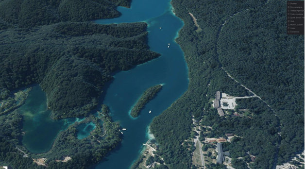
Digital terrain model visualization of Plitvice Lakes, Croatia, demonstrating the precision of lidar technology in capturing complex karst topography and hydrological features. The bare-earth model reveals the intricate limestone formations and terraced lake system that characterize this UNESCO World Heritage site. Croatia’s nationwide lidar campaign, completed in 2023, achieved exceptional point densities that enable detailed analysis of such sensitive environmental areas, supporting both conservation efforts and sustainable tourism management in the country’s most visited national park.
Croatia is also positioning itself as a potential contributor to a future pan-European lidar dataset. Its national program demonstrates both technical capability and commitment to open access that aligns well with European Union data strategies. The combination of complete coverage, exceptionally high point density, and unrestricted availability offers a valuable model for other countries in the region.
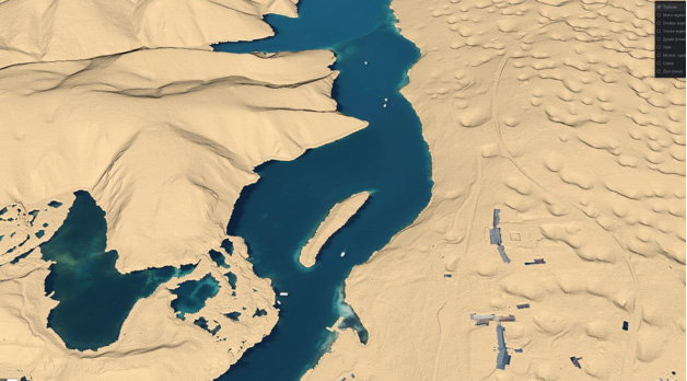
3D view of the lidar-derived DTM textured with high-resolution aerial imagery at Plitvice Lakes National Park, showcasing the country’s comprehensive approach to geospatial data collection. The crystal-clear waters and dense forest canopy illustrate the challenging terrain conditions that Croatia’s advanced lidar systems successfully penetrated during the 2022-2023 nationwide survey. With point densities exceeding 15 ppsm, the dataset provides unprecedented detail for monitoring this fragile karst ecosystem, where water levels and forest health are critical indicators of environmental stability.
Germany: federal structure meets national vision
Germany’s approach to lidar data acquisition reflects the country’s federal political structure. For years, airborne laser scanning campaigns, data processing, and public access were managed individually by each of the 16 federal states (Bundesländer). This decentralized model resulted in widespread but uneven lidar coverage, with variations in data formats, point densities, update cycles, and access policies. However, this structure also enabled states to tailor data collection to local needs and build early momentum in key applications such as forestry, flood modeling, and archaeology.
By 2025, nearly all of Germany will have been surveyed at least once with lidar, with most states offering DTMs and DSMs at one-meter resolution (DGM1). Point densities across these state-led initiatives typically range from 4 to 8 ppsm, though higher densities—10 to 20 ppsm—are occasionally achieved in urban or specialized areas. Data acquisition usually occurs during leaf-off seasons to improve ground visibility, and delivery formats vary slightly between states. Open data policies have become increasingly common, with many states—including North Rhine-Westphalia, Thuringia, Berlin, and Bavaria—providing free access, through state-level geoportals, to both raster models and, in some cases, classified point clouds.
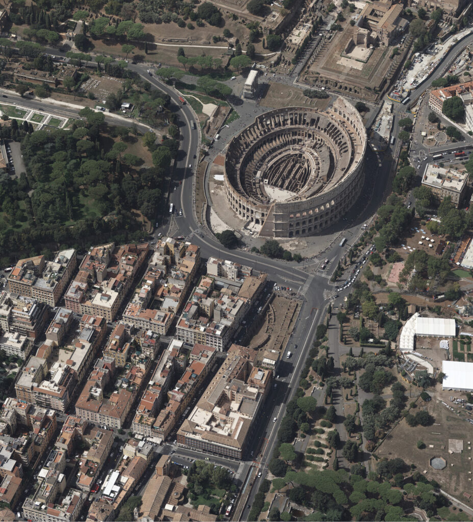


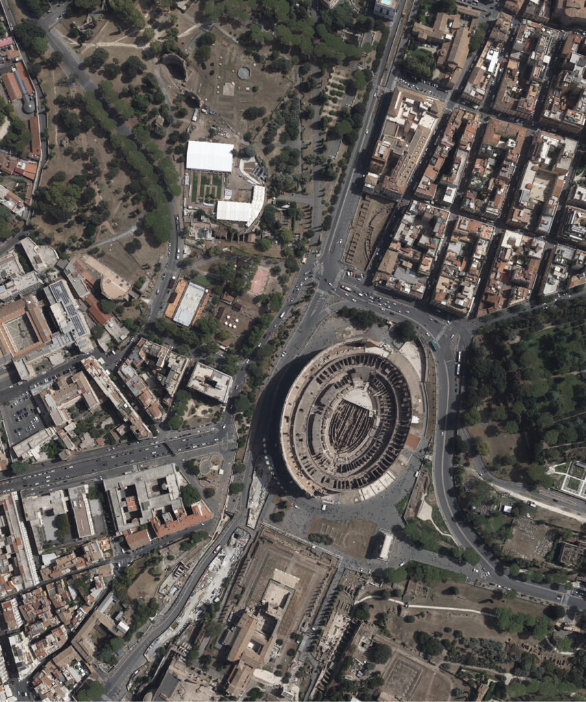
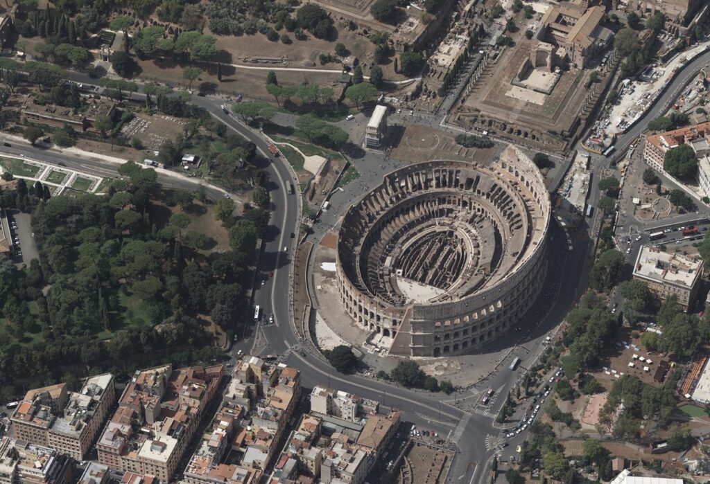
These high-resolution 5-centimeter pixel oblique and nadir aerial photographs of Rome’s Colosseum, captured by Italian Remote Sensing from aircraft, exemplify the precision achievable through modern airborne remote sensing technologies. As Italy transitions from fragmented regional lidar projects to its ambitious nationwide mapping campaign launched in 2024, such detailed aerial imagery demonstrates the country’s growing capacity to document and preserve its unparalleled archaeological heritage alongside comprehensive topographic surveying of the entire national territory. EAASI companies CGR SpA (Compagnia Generale Ripreseaeree) and Italian Remote Sensing Srl won the tender and will carry out the data capture for Italy’s national lidar program. Italian Remote Sensing.
A major transformation is currently underway at the national level. For the first time, Germany is conducting a nationwide lidar survey, coordinated by the Federal Agency for Cartography and Geodesy (BKG6) as part of the “Digital Twin Germany” project. Running from 2024 to 2026, this federal initiative aims to generate a consistent, high-resolution, three-dimensional dataset for the entire country. Unlike earlier state-led efforts, the federal campaign is conducted during the vegetation season and includes the acquisition of both lidar and aerial imagery from the same platforms. Sensors such as the RIEGL VQ-1560 II-S, VQ-1460, VQ-780II-S, and Leica SPL100 are being deployed across eight regions simultaneously.
The deliverables will include colorized and classified point clouds following a standardized classification scheme based on Arbeitsgemeinschaft der Vermessungsverwaltungen der Länder der Bundesrepublik Deutschland (AdV) and American Society for Photogrammetry and Remote Sensing (ASPRS) standards. These classes will distinguish features such as buildings, bridges, ground, vegetation, power lines, and water bodies.
A national point density of 40 ppsm has been selected—a resolution first tested in a 2021-2022 pilot project in the Hamburg metropolitan area. This density represents a practical balance: dense enough to support high-precision applications such as three-dimensional object recognition, vegetation structure analysis, and infrastructure modeling, yet still viable in terms of cost and processing. The full dataset is expected to be available to the federal administration by mid-2026, with broader public access likely to follow.
Lidar data in Germany already supports a broad spectrum of applications, including flood risk mapping, environmental monitoring, transportation planning, and cultural heritage conservation. The Digital Twin Germany project is expected to significantly expand these capabilities. Once the nationwide dataset is complete, federal authorities plan to perform change-detection analyses using repeat acquisitions to identify temporal trends in land use, vegetation, and infrastructure.
Although a unified pan-European lidar dataset remains a complex goal due to organizational and technical challenges, Germany sees bilateral harmonization—especially in cross-border areas—as a more achievable first step. Designing tools that can operate across varying resolutions and acquisition timelines will also be essential for scaling up analysis at the continental level.
Germany’s geospatial strategy is evolving. While the federal system has enabled diverse and locally responsive data programs, the emerging national framework signals a shift toward greater standardization, integration, and analytical ambition. With both state and federal initiatives now advancing in parallel, Germany is establishing one of the most detailed and future-ready three-dimensional geospatial infrastructures in Europe7.
Greece: modernizing through aerial innovation
Over the past three decades, Greece has undergone a remarkable transformation in modernizing its geospatial and cadastral systems. At the heart of this transformation lies the national cadastral project—one of the most ambitious infrastructure initiatives ever undertaken in the country—and increasing reliance on aerial surveying technologies to build a comprehensive, authoritative mapping framework.
Historically, Greece lacked a national land registry. Land ownership was managed via fragmented, manual registries (ypothikofylakeia), often based on narrative descriptions and lacking precise spatial reference. This situation posed major legal and developmental challenges, including land disputes, inefficient urban planning, and delays in infrastructure projects.
In response, the government launched the Hellenic Cadastre project in the late 1990s, aiming to develop a unified, modern, spatially accurate cadaster. Over time, the project has evolved into a complex, multi-phase national initiative, integrating geospatial data, legal ownership records, and topographic mapping. The transition from analog to digital spatial data required a consistent strategy and massive geospatial data acquisition efforts, often led by aerial surveys.
The public body responsible for this development, now known as Hellenic Cadastre (Ktimatologio), is charged with creating and maintaining the cadastral base for the entire national territory. Coverage currently spans both urban and rural areas and integrates land parcel boundaries, orthophotos, and other foundational geospatial data.
A key enabler of the cadaster’s progress has been systematic use of aerial surveying technologies, particularly aerial orthophotography. These methods provide high-resolution, spatially accurate data that serve as the geospatial backbone for the land registry.
According to Dr. Panos Lolonis, Head of the Geospatial Information Department at Hellenic Cadastre, aerial surveys have been systematically conducted to support various phases of the cadastral project. The core dataset is built on orthophotos derived from aerial imagery, with varying spatial resolutions depending on application: urban areas utilize orthophotos generated from imagery with 20-centimeter resolution, while lower-density rural areas are mapped with 50-centimeter resolution.
These orthophotos are produced using block adjustment processes and form the basis for digitizing parcel boundaries, interpreting land use, and supporting legal adjudication. The imagery has been integrated into web services and GIS platforms used by municipalities, engineers, surveyors, and the public.
Aerial imagery acquisition was performed in cooperation with private surveying companies, ensuring consistency across regions. As of 2024, Greece had achieved complete national coverage in terms of orthophotos—a significant milestone considering the country’s diverse topography and thousands of islands.
Until recently, lidar had not been widely adopted across Greece’s cadaster, due partly to cost and limited capacity. However, this is changing rapidly.
Lidar integration is now seen as a strategic priority for the future. As Lolonis emphasized during his 2024 EAASI Summit presentation, incorporating lidar into the national mapping portfolio would significantly improve three-dimensional cadastral applications and enable more detailed DTMs and DSMs, especially in areas prone to landslides or flooding.
Future projects include detailed DSM and DTM development at one-meter grid size, set to cover southern Greece by 2025. A follow-up project for the northern half will be launched afterwards. The data will include classified land categories such as buildings, vegetation, and water, improving environmental and urban planning capabilities.
The expectation is that as funding and policy alignment with European digital and environmental initiatives improve, broader lidar coverage will follow. Forthcoming EU directives on Green Deal implementation, nature restoration, and disaster resilience are expected to catalyse investment in lidar and related technologies.
Greece is also involved in the Open Maps for Europe project8, aiming to create a seamless cadastral and topographic dataset for Europe. These developments will contribute to establishing a modern National Spatial Data Infrastructure (NSDI).
Italy: from fragmentation to national unity
Italy’s journey with lidar has long been marked by fragmentation. For years, the country lacked a coordinated national strategy for airborne laser scanning. Instead, lidar coverage developed through a patchwork of regional and thematic projects, often driven by local needs such as flood risk mapping, coastal management, or archaeological research. While these efforts produced valuable datasets, they were limited in scope and coverage, leaving large parts of the national territory unmapped.
Several significant initiatives laid the groundwork for today’s progress. The Piano Straordinario di Telerilevamento Ambientale (PST)9, conducted in phases between 2008 and 2015, targeted coastal zones and areas classified as hydrogeologically vulnerable. Lidar data from this program supported the development of DTMs for flood prevention and environmental protection, but never extended to the entire country. Other regional projects—such as those in Lazio, Calabria, and the Po river basin—also produced high-resolution DTMs (often with resolutions of one to two meters), frequently with specific applications in forestry management, hydrology, or archaeological site preservation.
Recent efforts have continued this thematic focus. The PNRR MER project (Marine Ecosystem Restoration)10, running from 2024 to 2026, is applying lidar and other remote sensing technologies to map Italy’s full coastline and marine habitats. However, as with earlier initiatives, the project is geographically limited to coastal and marine zones.
A major shift began in 2024, when Italy launched its first-ever nationwide lidar mapping campaign. Led by the Ministero dell’Ambiente e della Sicurezza Energetica, this project represents a milestone in Italian geospatial policy and data infrastructure. For the first time, the entire national territory will be surveyed using airborne laser scanning, with uniform technical standards and centralized coordination. Scheduled for completion in 2026, the project sets a high benchmark with a target point density of 10 ppsm, placing it among Europe’s most detailed national lidar programs to date.
The campaign’s goals are comprehensive. It is designed to support flood risk assessment, environmental monitoring, sustainable land use planning, forestry, agriculture, and heritage preservation. In contrast to past efforts that served narrow institutional needs, the new dataset will be made available for widespread use across government, academia, and the private sector. By delivering consistent, high-resolution topographic data, Italy aims to modernize its geospatial infrastructure and unlock new applications in climate adaptation, biodiversity conservation, and digital innovation.
With the project now well underway, Italy is catching up with—and in some areas exceeding—standards set by other European countries. The transition from scattered regional projects to a unified national dataset marks a major step forward. If successfully completed and fully opened to public use, the national lidar program will equip Italy with the foundational data needed to manage natural risks, protect cultural and environmental assets, and foster digital transformation across sectors.
Looking forward: Europe’s geospatial evolution
The experiences of Austria, Croatia, Germany, Greece, and Italy illustrate both the diversity and dynamism characterizing Europe’s approach to lidar mapping. From Croatia’s rapid achievement of complete national coverage to Germany’s ambitious Digital Twin initiative, from Greece’s systematic cadastral modernization to Italy’s transition from fragmented regional efforts to unified national strategy, each country demonstrates unique pathways towards comprehensive elevation data infrastructure.
These national efforts, while distinct in their approaches and timelines, collectively represent Europe’s growing recognition of lidar technology’s critical importance for addressing 21st-century challenges. Whether supporting flood risk management, environmental monitoring, urban planning, or heritage preservation, high-resolution elevation data has become indispensable for evidence-based decision-making.
As Europe continues evolving its geospatial capabilities, the experiences documented in this series—spanning 16 countries across three instalments—provide valuable insights into both the opportunities and challenges that lie ahead. The path towards greater coordination, standardization, and accessibility remains complex, but the progress achieved by individual nations offers encouraging evidence of what can be accomplished through dedicated investment in aerial surveying technologies and open data policies.
Acknowledgments
Dipl.-Ing. Wolfgang Gold, BEV – Bundesamt für Eich- und Vermessungswesen (Federal Office of Metrology and Surveying, Austria); dr. sc. Marijan Marjanović, dipl. ing. geod., Državna geodetska uprava (State Geodetic Administration, Croatia); Andreas von Dömming, Bundesamt für Kartographie und Geodäsie, Federal Agency for Cartography and Geodesy (BKG) , Germany; Panos Lolonis, Ph.D., Hellenic Cadastre, Greece.
- 1 Perello, A., 2023. Elevations for the nations: understanding Europe’s varied approach to lidar mapping, LIDAR Magazine, 13(3): 41-45, Fall 2023. https://lidarmag.com/2023/10/07/elevations-for-the-nations/
- 2 Perello, A., 2023. Elevations for the nations: understanding Europe’s varied approach to lidar mapping, Part II,LIDAR Magazine, 14(3): 40-48, Fall 2024. https://lidarmag.com/2024/09/22/elevations-for-the-nations-part-ii/
- 3 eaasi.eu
- 4 https://www.bev.gv.at/en.html
- 5 https://dgu.gov.hr/
- 6 https://www.bkg.bund.de/EN/Home/home.html
- 7 For readers seeking a detailed, interactive overview of current lidar data availability and access portals by state, an up-to-date resource is available at lidar Availability in Germany, by Jens Wiesehahn. This site provides a map-based summary of which German states offer open lidar data, including specifics on data formats and download options. It is regularly updated to reflect new releases and changes in access policies.
- 8 https://www.mapsforeurope.org/
- 9 https://gn.mase.gov.it/portale/en/not-ordinary-plan-of-remote-sensing
- 10 https://www.isprambiente.gov.it/en/projects/sea/pnrr-mer-marine-ecosystem-restoration