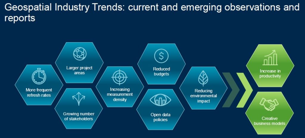
We lidar people must remember that a Hexagon user event is much broader than it used to be. There’s far more than surveying and photogrammetry hardware and software. LIDAR Magazine, therefore, had to be selective, focusing on topics likely to be of interest to readers. The most obvious was the airborne sensors.
After the round-table with Henning Sandfort on the second day, I interviewed John Welter, president, Hexagon Content Solutions. He needs no introduction here and is a contributing writer at LIDAR Magazine: we’ve published an article to introduce John to readers[1], one of hiss pieces has already appeared and more are coming. I referred him to the informative webinar Anders Ekelund had given on 25 March 2025 about the CoastalMapper and asked him to elaborate on Anders’s remark that some aspects were still under development. He explained, “We do quite a bit of testing, but then our customers take it into different environments that bring up new data sets, which we can use to do some additional algorithm tuning to get more performance. And the nice thing is, because it captures the full waveform, if we come up with algorithmic improvements, you can apply those to data collected earlier on. So it’s evolution.” In the earlier HawkEye-4X and Chiroptera-4X, the “4X” represented increased performance owing to new signal-processing algorithms. These improvements can be applied retrospectively, i.e. used to re-process existing data sets. “This is a journey,” he added. “We get 80 or 90% on day one, but then over time we’ll unlock the rest and our customers will benefit.”
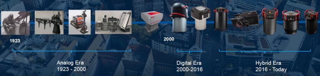
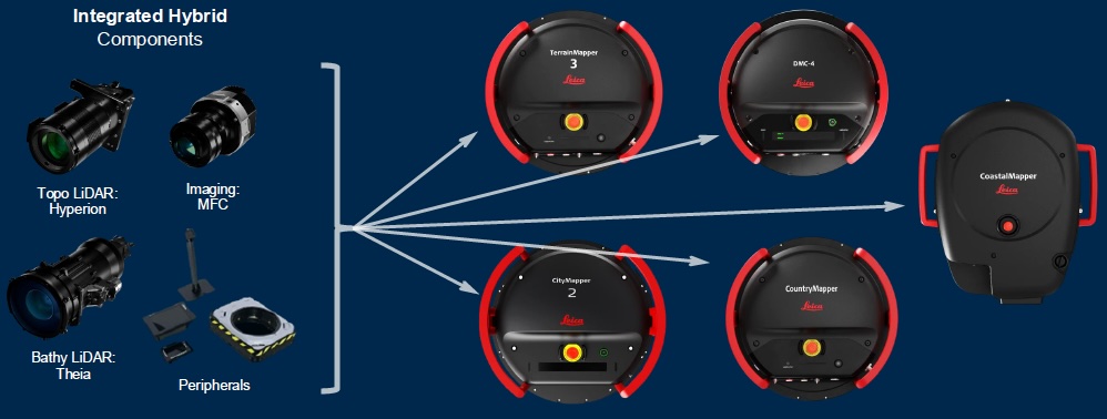
I complimented John on the appearance of the CoastalMapper and he replied, “It’s the first new from-the-ground-up AHAB sensor since we acquired them,” referring to Leica Geosystems entering the bathymetric lidar world through the acquisition of Airborne Hydrography AB, a spin-off from Sweden’s Saab group, in 2013. The design house Igl, famous for decades for making Heerbrugg products look futuristic, was involved, and SwissOptic helped with the system’s complex optics.
We moved on to the DMC-4X. John explained that on big US federal programs such as NAIP there is a push for greater efficiency, and in 2024 Hexagon had won a bigger portion of this work than in previous years, by 30-40%. John’s original company, North West Geomatics, acquired by Hexagon in 2014, had begun work on NAIP in 2005. Rather than purchase 30% more aircraft to address the 2024 challenge, John asked his R&D team to add 30% more pixels. The DMC-4 had always had three camera heads across the format and they managed to squeeze in a fourth. This new variant worked well in 2024 and customers have been effusive about the quality of the imagery.
We turned to the new Sony IMX811 247-megapixel sensor, already deployed in TerrainMapper-3 and CoastalMapper. John explained that the airborne sensors all use the MFC150 camera module, which is based on the Sony IMX411 150-megapixel sensor. More than 600 have been shipped inside the airborne sensors so far. This will be superseded by MFC250. John whetted my appetite with a hint that there would be a big announcement at Intergeo.
We turned to the SPL100 single-photon lidar system. Hexagon itself is flying eight of these, and more are in use by certain customers, so they’re doing a lot of work. They want to commercialize this technology more, which includes transferring manufacture to Heerbrugg, though the former Sigma Space facility continues to produce customizations for federal agencies. This product direction is not a new idea and, indeed, was very seriously delayed by covid and issues with sourcing the laser. At present, however, a prototype is flying that includes a decent proportion of the required functionality – stand by for another big Hexagon announcement!
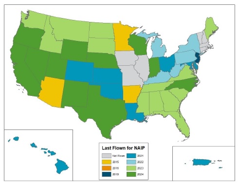
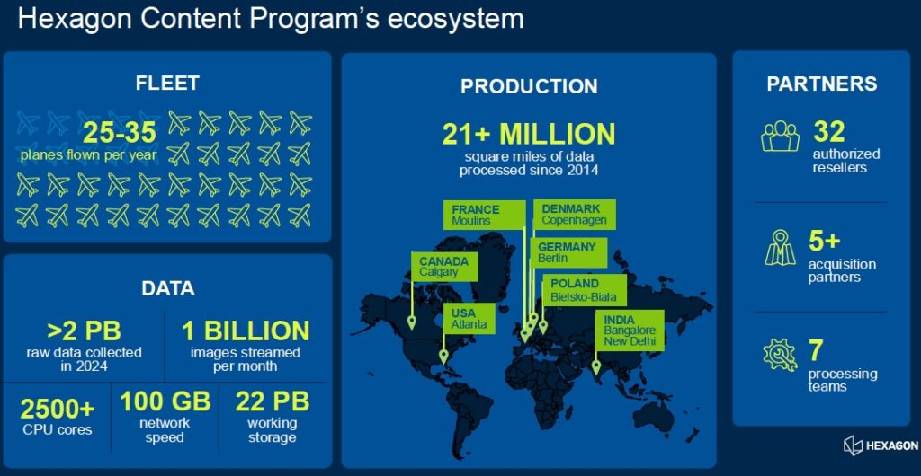
Like other Hexagon leaders I had interviewed, all the way back to Bruce Wald in 2018, John was reluctant to provide statistics regarding the Hexagon Content Program. He couldn’t disclose names of big customers. He did comment, however, that over a billion images are being streamed weekly. There are peaks after natural disasters, for which Hexagon provides imagery free of charge. Though reticent about the program, Hexagon admits to being the data source behind lots of other business. There is some elevation data available. Some of the target areas are flown with CityMapper systems, so 3D data comes naturally. The New York city data set used to demonstrate HxDR is an example. There are plans to make greater use of SPL technology in the program. If SPL is used for NAIP, then there will be elevation data too. I commented on the recent Hexagon release about NAIP awards and John explained that a very productive agreement allows USDA to own the products made specifically for NAIP, whereas Hexagon owns derivatives made from the same imagery. For example, the imagery can be flown at higher resolution than NAIP requires, so higher-resolution products are possible too. NAIP benefits from this: its data acquisition costs have fallen over time. Hexagon has flown states that are not included in NAIP plans, then sold the data to NAIP.
I asked John the same question I had asked Sandfort, starting from the acquisition of APEI and wondering about Hexagon competing with its customers. John’s take was that APEI had been a sub-contractor to Hexagon for many years. He will not step on his customers’ toes. If there is an imagery or lidar requirement, Hexagon gives its customers first right of refusal – they get first chance to fly, even occasionally with additional sensors lent by Hexagon. Hexagon avoids initiatives to acquire prime contractors. Typically, small companies like APEI go to larger ones for help with processing. The acquired companies enjoy more stability, plus access to additional sensors if they need them at times of peak demand.
We were joined by another journalist and there was a broader discussion about bathymetric lidar. Although geospatial professionals understand the technology’s potential, more education may be needed for other end users. The management of coastlines and shallow-water areas are critical to multiple user groups, such as beachgoers, boatowners, waterside property owners and scientists. All the systems can capture data over land too, so the coastal zone if fully covered. Some countries embraced bathymetric lidar early on, others less so. There are now customers with multiple topobathymetric sensors. NOAA has had big coastal programs for some time. John shared my excitement that the successor to 3DEP includes inland waters.
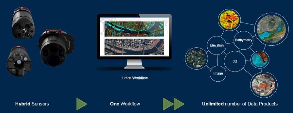
We explored Hexagon’s commitment to hybrid sensors. All the airborne sensors follow this model and make use of common components wherever possible. John illustrated the idea by saying that CountryMapper is the top-performance sensor in both imagery and lidar. Lidar can be removed to give DMC-4, or imagery removed to give TerrainMapper-3. Users may upgrade, for example adding lidar to a DMC-4. Having both imagery and lidar capabilities in an aircraft is extremely convenient operationally and enables both companies and government agencies to make maximum use of their fleets without having to return to base to pick up another sensor, or ship it with the accompanying risk of damage. Hybrids also make it easier to address customers with different pots of money for imagery and lidar. Reducing the amount of flying is a worthwhile cause, environmentally and financially.
We were running out of time, but moved on to the EAASI organization and its concerns about the practical difficulties of complying with regulations and getting projects flown. John explained that Europe is complex, with nuances in each country, whereas in the US the tendency has been to operate larger aircraft that can fly higher, flown by pilots with both Visual Flight Rules and Instrument Flight Rules certifications. Then the data collection aircraft is flying the same way as commercial aircraft – and air traffic control likes that. John said that sometimes his group goes even further. Before they fly a project, they request a meeting with the management of the local regulatory body, take maps with them, explain what they want to do, strive to understand how the local air traffic control people would like them to work, then make a plan. And don’t forget to give them orthomaps of their airport at the end! John felt that acquisitions and consolidation gave companies more strength that would help them in this respect. Engineering companies are coming into mapping and they are bigger. More resources enable a company to be more professional, e.g. a dedicated ATC manager. Maybe EAASI could help educate ATC leadership. Maybe it would help if national mapping agencies in Europe contracted out their data acquisition. Airspace will always be a challenge! Reluctantly, we dragged ourselves away from this most engaging conversation. There’s so much more to this world than just the sensors!
The afternoon included an airborne systems update, provided by Stephen (Steve) Cooper, global sales manager – airborne systems, a recent catch from Phase One, and Ryan Boswell, sales manager – airborne systems, both based in Colorado. I had spent time with Boswell the previous day in the Zone, looking at CountryMapper and CoastalMapper. The latter is huge owing to the cooling system for the Theia bathymetric sensor. The afternoon session – by invitation only, to boot – provided all the detail. The speakers zoomed through 90 slides, a mixture of what we knew and what is new. There wasn’t the slightest gasp from the audience when Steve indicated that the price points rise from $1.2m to $3.5m. Undergirding the superb technology are two principles – hybrid sensors, and “fly once, use many times,” the latter the mantra of the content program. The presenters frequently reiterated their message: integrated workflow supporting multiple sensors and multiple products.
The content program, of course, is a key part of Hexagon’s airborne activity. The company can now deploy 25-35 aircraft for data acquisition. It has successfully contracted for major parts of the huge NAIP program in the US and in 2024 flew over 100,000 km2 per week with ContentMapper and DMC-4X, reaching a peak of 238,242 km2. Cooper contrasted the volume of output with work he had done using film in UK in the 1990s.
While describing the various sensors, modules and software, Cooper confirmed that something for helicopters is in the pipeline as well as an innovation on the single-photon side. There will also be new product names. Go to Intergeo and fine out!
[1] Welter, J., 2025. New author introduction: John Welter, LIDAR Magazine, 15(2): 6-8, spring 2025.