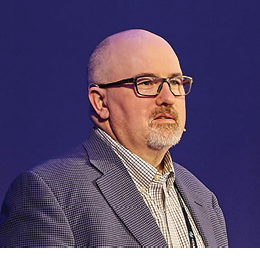
John brings over three decades of deep industry experience. His expertise spans geospatial services, airborne mapping technologies, IT strategy, and big data – all areas where his leadership and input have left their mark.
With his broad knowledge and passion for progress, John’s voice is a welcome addition to the LIDAR Magazine community.
A beautiful example of bathymetric data captured with a Leica Geosystems airborne sensor.
A family of surveyors
John’s introduction to the geospatial world didn’t happen in a university lecture hall or graduate program. His father, Fred Welter, was a land surveyor and part of a legacy that stretched across the Yukon, Alberta, and into Alaska, originally through the firm Hosford, Impey & Welter, which eventually spun off into North West Geomatics. As a young boy growing up in this family-run surveying business, John spent summers carrying tripods and maintaining field equipment at North West Geomatics. In his teenage years, John would travel the world as part of a North West Geomatics field crew, working with a Leica RC20/30 aerial film camera on various mapping projects – a summer job that would go on to shape much of his career.
After earning a degree in electronics and systems engineering from North Alberta Insitute of Technology, John began his career. He soon found himself drawn into the family business to pursue innovations in the evolving world of geospatial technology as CTO. The introduction of airborne GPS, automated flight management, softcopy mapping systems, and film scanners positioned North West as one of the technology front-runners in the industry.
The Hexagon era
North West Geomatics’ longstanding partnership with Leica Geosystems set the stage for what would be a natural evolution: Hexagon’s acquisition of the company. John had already built strong ties with Leica Geosystems’ technical team as North West Geomatics had been an early adopter of the Leica ADS40 airborne digital sensor and among the first to deploy its airborne lidar (ALS) technology. John’s North West Geomatics team even developed its own workflow in-house, which would later be commercialized as Leica XPro.
Point cloud captured with Leica CityMapper-2 hybrid system in Tokyo, Japan.
Today, as head of Hexagon’s GCS team, John leads a uniquely positioned group that bridges tradition and innovation. On one side is the airborne sensor line, first launched in 19231 and now the most established in the industry. On the other is the fast-paced, ten-year-old Content Solutions, designed to deliver large-scale projects quickly and drive innovation through collaborative data-sharing models, such as the Hexagon Content Program2. It’s a dynamic balance: one half operating in a two-to three-year year product release cycle, the other moving at the pace of two to three weeks – which John says keeps him on his toes.
In his current role, John’s mandate is simple yet ambitious: ensure that Hexagon Geosystems’ technology – whether sensors, services, or data (and often a combination of all three) – is used on all major mapping programs around the world.
Leading at the cutting edge
The work John and his team are doing is certainly leading edge. One of the most exciting initiatives in which he has participated is the role of AI in transforming geospatial data from a reactive tool into a proactive one. Previously, remote sensing meant archiving data for use after something bad had happened, like a natural disaster. But now, AI enables real-time analysis so that people can monitor subtle environmental changes before they become big issues.
Elevation data captured with Leica TerrainMapper-3 lidar system in Dornbirn, Austria.
Besides the technology itself, John is motivated by the broader impact it can have on the world we live in. This future-forward thinking is at the heart of R-evolution3, Hexagon’s sustainability-focused arm, where his team and their products play a leading role – for example, mapping Costa Rica’s rainforests4 to preserve biodiversity. These projects reflect a personal mission to help safeguard the planet. He hopes his teenage children will benefit from this and be able to enjoy the results.
A message to the next generation:
For John, the geospatial industry has been a lifelong adventure. While aspiring engineers tend to lean toward big tech, John makes a strong case for pursuing a career in the geospatial industry.
For example, the airborne sensors his team designs are so advanced that some of Hexagon’s sub-suppliers use them as R&D testbeds to develop their most advanced solutions.
For those who love technology and want to see the world, John believes there’s no better industry. Whether it’s collecting data in Colombia, mapping coastlines in Trinidad and Tobago, or overseeing projects in Zimbabwe, his work has offered not only technical challenges but global opportunities. It’s a dynamic, high-tech, and rewarding career, one that deserves far more recognition and visibility.
Lessons that last
John has learned a powerful lesson from his nearly 40 years in the field: never forget the customer. Whether providing sensors, data, or services, success can only come from understanding and supporting the people who rely on the tools you build.
He’s less concerned with awards or recognition than with enabling his customers to succeed. For John, the best reward is seeing a customer take a Hexagon solution and apply it in a completely novel way. One example is a customer who recently used its airborne sensor to monitor nighttime light pollution and energy consumption, despite it originally being designed for daytime mapping. Seeing this new application, John’s team then worked closely with the customer to improve nighttime surveying performance.
It’s these examples of collaboration, creativity, and impact that continue to motivate him. We look forward to sharing more insights from John.
- 1 https://lidarmag.com/2023/05/24/100-years-of-innovation-in-heerbrugg/
- 2 https://hxdr.com/contentprogram/
- 3 https://r-evolution.com/
- 4 https://lidarmag.com/2024/05/04/
digital-twins-open-up-new-possibilities-for-rainforest-conservation/