A new venture is formed …

Figure 1: Example from the NV5 UAV fleet: BFD Systems SE8 heavy-lift, long-endurance octocopter.
Many business travelers must have wondered how to manage the return to normality as covid receded1. My resumption was pleasantly gentle and local—a regular contributor to LIDAR Magazine, Mark Meade, who is based in Lexington, Kentucky and is senior vice president shared services, NV5 Geospatial, invited me to an NV5 office only four miles from my home. This office, in the northern suburbs of San Diego, houses NV5’s Unmanned Systems group (“USys”), managed by Mike Stys, senior vice president of geomatics and unmanned systems. Much of the capability, and numerous staff members, had been parachuted into NV5 as a result of the acquisition in December 2017 of Skyscene, a UAV services startup in San Diego. NV5 Geospatial is the name for yet another acquisition—the geospatial and data analytics conglomerate Quantum Spatial, acquired in December 2019.
Mark mentioned Geodyamics, purchased in March 2021 to strengthen NV5’s deep-water portfolio, “They have significant capabilities, and their professionals are great to work with.” Mike said that there had already been several interactions between his group and Chris Freeman of Geodynamics. NV5 had purposely named his team “Unmanned Systems”, because, in the future, unmanned vehicles will go beyond aerial. “We have a USV2 in place. Space, air, land and sea, we’ll do it all and we’re looking at one for mining, to go into caverns and canyons. We’ll solve the technical challenges.”
The company has come a long way from the DJI Inspire and RIEGL lidar sensor they started with. NV5 quickly invested in a more robust platform along with a RIEGL VUX-1 lidar sensor. The team then built a group of dedicated professionals and subject matter experts who quickly integrated sensors on the DJI M600 platform. Within months, they were producing engineering-grade orthomosaics and lidar point clouds to use at NV5. The fleet of UAV platforms and sensors continues to expand and includes American-made UAVs (Figure 1), multiple lidar sensors, and thermal and multispectral cameras. Mike emphasized, “The strength of this team is its understanding of survey and engineering first, then UAV operations second”.
Indeed, the group is considering expanding its topobathymetric capabilities. Though impressed with the penetration, point density and accuracy of the ASTRALite EDGE sensor3, the team was concerned that its low flying height could compromise coverage, so they’re looking up market, at the RIEGL VQ-840-G. This weighs about 15 kg (33 lb) with GNSS and IMU, however, so it doesn’t fly on a small UAV. Some UAVs can cope with such payloads, such as RIEGL’s own RiCOPTER-M, but the regulatory environment becomes more complex for UAVs above 55 lb.
Mark interjected that NV5 Geospatial had just completed a test of the VQ-840-G with RIEGL and GEO1. Ron Chapple4, GEO1’s CEO, provided a helicopter; NV5 Geospatial, the sensor operator and the processing; and RIEGL, the VQ-840-G. The test site was Morro Bay, California. Results are imminent and Mark hinted that early indications were very promising.
… with talented, energetic people …
Mainly, this is a story about people. Also present for my visit were Melissa Christie, a NV5 geospatial account manager based in the Bay Area, and Kurt Kathol, UAV account manager. Joining remotely from Fredericton, New Brunswick, Canada, was Lukas Fraser, lidar specialist and engineer-in-training.
Mike, a Michigan State and Ohio State graduate, entered the geospatial profession after graduating in 1991 and worked initially in GIS, then began to work with terrestrial laser scanning (TLS) in 2000-01, always in the AEC space. At one point he purchased a VZ-420 from Ted Knaak, who at that time was president of RIEGL USA. Mike, who is also a member of ASPRS, reached his current position through NV5’s acquisition of WHPacific in 2019, after which NV5 asked him to take the lead on the company’s geospatial team. But things changed with the purchase of Quantum Spatial a few months later—the geospatial team grew a tad! His operation, therefore, became focused on unmanned systems and the team is now 22 strong, of whom five are key pilots, lidar-trained and ortho-trained. Born and raised in Michigan, Mike came to California eight years ago. His WHPacific role had expanded to running multiple offices across the western US, so he has been pleased that his current assignment is more focused.
The early part of the story has been reported elsewhere5. Kurt started out with drones, working for the Department of Homeland Security, US Customs and Border Protection, on surveillance of the southern border, then co-founded Skyscene with Matt O’Brien, who came from the construction industry. After Skyscene was acquired, Matt and Kurt occupied management positions within NV5.
Mike added, “We have the luxury of Kurt playing a role where he’s obviously got the technical capabilities and knowledge, but he’s also our account manager, because he does a wonderful job selling our services. So, he’s migrated out of operations and more into business development.”
Melissa worked for USGS Water Resources Division in Carson City, Nevada, National Park Service in San Francisco, and, since 2004, in private industry, when she moved to HJW Geospatial, which was acquired by Photo Science in 2010. The latter became Quantum Spatial in 2013. Some readers will remember that HJW moved from its facility near Oakland Airport to downtown Oakland, where it occupied what had been a department store, all the more appropriate since it was briefly under the ownership of Harrods, the famous Knightsbridge emporium in London, UK. Mark quipped, “There were no synergies with Harrods—zero!” Harrods’ boss Mohamed Al-Fayed sent a representative to Oakland periodically, who could not fathom what went on, lots of people on workstations in dark rooms, looking at photos and clicking on points and lines.
Melissa has been an ASPRS member since 2000 and is in her fifth year as secretary/treasurer of the Pacific Southwest Region. Though she works in all the western states, her focus lately has been on California. She was enthusiastic, “Mark’s been so great to help me work through all the opportunities in California, including the Unmanned Systems group. Speaking of synergy—we’re already experiencing cross-pollination, working with each other and bringing jobs from all over.” She felt that the NV5 Geospatial strategy had been to let the UAV services market mature and this has happened. When she approaches clients or they approach her by saying that they have a small site, don’t want to go overboard, and want to understand what their options are, she can now answer that NV5 can collect a project, with high accuracy and high precision and certain cost efficiencies. “I think that it’s a wonderful synergy because we can sell this, we can talk about it with confidence. Also, the approach to selling UAV-lidar services by a surveying and mapping company is intriguing, because it’s not the same as with the projects they’ve been selling until now, i.e. big projects with manned aircraft,” Melissa explained. “It’s not a different world, but it has its peculiarities”.
Mike envisions a tremendous amount of additional opportunity, “Fortunately we have a few thousand clients right under our nose here, with NV5—we’re a multidisciplinary, worldwide company.”
Mark was animated, “Synergies are really good! It’s probably one of the more aggressive initiatives at NV5.”
Lukas joined the conversation from Canada. He attended the University of New Brunswick for a geomatics engineering degree, then started working in the remote sensing industry, with Leading Edge Geomatics in Fredericton, New Brunswick. He concentrated on lidar processing, soaking up knowledge. “I got to oversee some really cool data sets. All of Puerto Rico, for example, I processed that. I traveled to Nantucket and Martha’s Vineyard, for the topobathy acquisition. I also had large projects in Texas and Virginia. We collected data for the whole provinces of New Brunswick and Nova Scotia. I was really focused on finding ways to process these enormous datasets as fast as possible, perform quality control of these huge areas, because, with enormous datasets, you can’t look through every square inch—I wanted to automate quality control and basically make sure that the results are good enough to be published, whether it’s through Natural Resources Canada or USGS.”
Kurt reached out to Lukas while the ink on the Skyscene acquisition was still wet. “Kurt messaged me on LinkedIn on Christmas Day. I thought he was probably a scam! He just ran a search on LinkedIn and my profile popped up. I had a very specific set of skills, I guess you could say.” Lukas was quickly added to the team. He was tasked to find a way to process the high-quality US data sets and turn them around efficiently, but not sacrifice any of the accuracy, or any of the quality control measures, such as the USGS Lidar Base Specification or the ASPRS Accuracy Standards for Digital Geospatial Data. Lukas ensures that NV5’s data sets meet clients’ accuracy requirements. His work has expanded, however, into making Civil 3D drawings, for example, or setting up services for clients in web browsers. Lukas summed it up, “Getting accurate point clouds is great, yet most people hate point clouds, clients don’t want to see them, they don’t want to interact with these huge data sets. So we need to make a product that people can use and provide value to our customers. We even touch the BIM world.”
Lukas currently works remotely and is looking to hire. Mike added, “There’s the University across the street, and he’s got the green light to go find more talent.”
Kurt, it turns out, is an ace recruiter. Mike elaborated, “Kurt has a sixth sense. One of our best mapping technicians was at a coffee house and Kurt started talking to him. He gave his background, Kurt offered him a job on the spot, and he’s one of our top producers.”
Kurt added that he had run the hiring of Lukas by NV5 Geospatial lidar whizz Andres Vargas. Kurt had been friends with Andres when they were with Skyscene and RIEGL USA respectively. The three had a teleconference and Andres opined on Lukas, “This guy’s the real deal.”
… who can run successful projects …
NV5 showcased several UAV-lidar projects for me.
Plaintiff vs. defendant—fence dispute
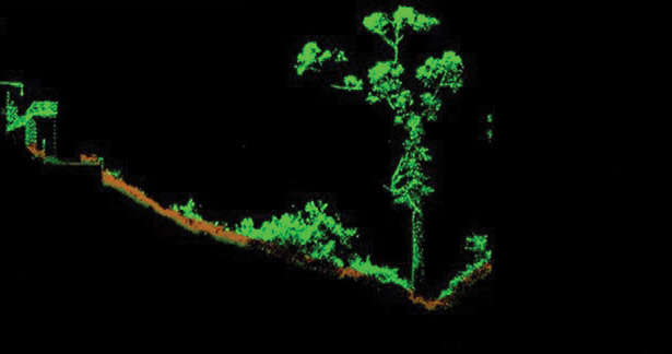
Figure 2: Cross-section through a dense lidar dataset. Note the bare earth surface and considerable vegetation.
The first was set in La Jolla, a coastal suburb of San Diego (Figure 2). Lukas explained that it was one of the group’s smaller projects. The motivation was one resident suing another for building a spike fence that blocked his view of the ocean. The yard was filled with dense vegetation. But it was possible to use the laser scanner to see down to the ground to create a satisfactory profile of the backyard, find the lowest point and measure from it to the top of the spike fence to prove that it was illegal—it was too tall. The UAV-lidar approach was very successful—Lukas described it, “We’re in between helicopters and planes and mobile. Obviously, we don’t quite have the same level of detail, but it’s enough for us to go in and map out her retaining walls and a lot of other features in 3D that were traditionally acquired through mobile, or photogrammetry. For example, we’re getting a really great definition on linear features, enough to do all that extraction. And once again, TopoDOT provides a semi-automated way of skipping through these data sets, getting all the break-lines and profiles.” The sensor was from the RIEGL VUX family.
Major southern California utility—pure water project

Figure 3: Digital elevation model generated without boots on the ground, which would have disturbed vegetation and provided challenges for navigating steep slopes.
Lukas moved to a larger project, also in La Jolla, executed for the City of San Diego (Figure 3). Again there were problems with very dense vegetation. The customer needed to see where all the drainage locations were. They had a DJI Phantom 4 and had flown it there, but couldn’t really acquire images through the vegetation and couldn’t build an ortho. They considered sending a crew in to look at it, but it was too dense, it wasn’t safe, and they were worried about hazards. They thought, however, that they knew a couple of locations where the water was draining. Therefore NV5 collected very high-density lidar and was able not only to verify the locations but even identify a few more that couldn’t be seen from the Phantom 4 photography. The customer was delighted with the lidar-derived data set, with enough detail to highlight exactly where the water was.
Ventura River diversion and leak repair
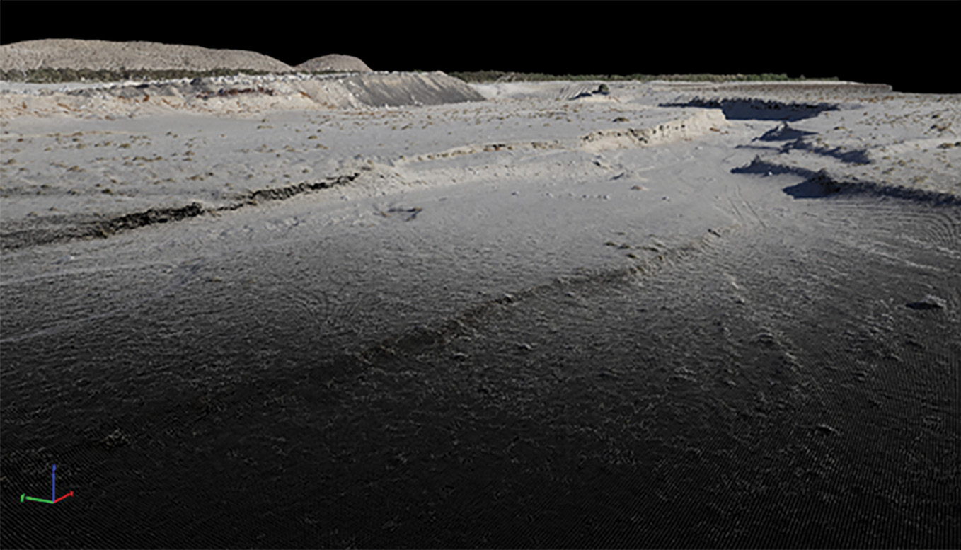
Figure 4: Dataset created from the fusion of sonar and aerial lidar.
Mike put the next project (Figure 4) in context: “UAV-lidar we do every day, we shoot down to the ground, we do it very well. A remotely operated sonar is something for which we’ve rented boats from time to time, but we’re really hoping to do more of these projects, because you can really see the added value of being able to collect topographic, and also the underwater elevation information for the project.” He was keen to win projects of which NV5 was well capable, but would perhaps hit challenges with topobathymetric lidar, perhaps for cost reasons or just water that’s too murky. So for this dataset NV5 merged lidar and sonar to create accurate data above and below water. The result is a seamless data set, with contours that flow from the ground to the bottom of the pond. The accuracy is slightly reduced with sonar, but is sufficient for many applications. The coverage of the site was complete. NV5 was able to estimate what would be required if the customer had to fill in the reservoir.
Company views campus as-builts and thermals in portal
The next example, the campus of a well-known company, was chosen to emphasize that getting the data into the client’s hands is so important that NV5 makes special efforts to come up with the right tool. This is a differentiator—it’s not sufficient just to excel at collecting data and checking that it’s precise and accurate. What happens next? Unmanned Systems enjoys the luxury of working for the larger NV5, so is exposed to field engineers, construction managers, people in the field making their clients happy. They receive “tribal” knowledge of what is expected and how to develop a usable tool. Lukas showed the result, a web-based portal developed in-house. Lukas likened the portal experience to broadening the audience among the client’s personnel. This opens up the use of the data and the client receives greater value. It’s intriguing to see how the data gets used. Melissa commented, “You want it to become easier, more user friendly—and in doing so even more people can get involved.”
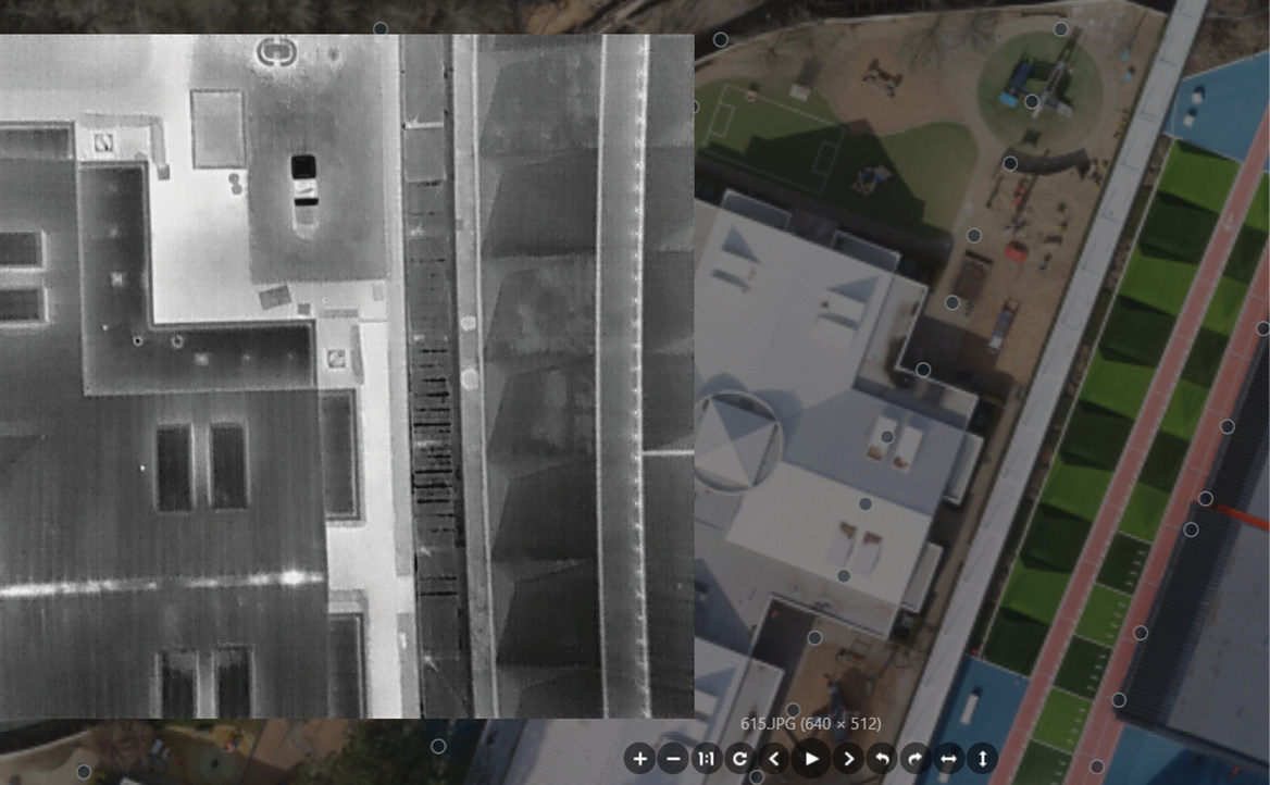
Figure 5: Combining orthomosaics and thermal imagery to identify anomalies in structures.
Lukas sketched the development of the portal. They worked first with a group internally, then incorporated feedback from clients. People are interested, but they can’t interact with these big datasets. For the campus project, they put all the Civil 3D data and AutoCAD drawings on the web so anyone can log in, take a look and manipulate the datasets. Layers can be turned on and off. The viewer can make distance measurements. Tools are being added continually, not just for measurements—there’s also a legend function. There are similarities to GIS software used by professionals, but the customer experience is much easier and people believe that they can do it. It’s possible to accomplish, in a web browser, anything that could be done with a point cloud in a normal GIS browser. Points can be classified. The user can choose what to see—intensity, elevation, class, etc. Cross-sections can be measured and downloaded as csv files.
Interestingly, one of the requirements for this project was thermal imagery, over and above lidar and conventional orthos. The team made a thermal viewer, so the customer could look at individual images and buildings. They worked on temperature gradients based on the values in the images. It’s easy to spot on a building an anomaly that should be investigated (Figure 5).
Architectural preservation in Florida
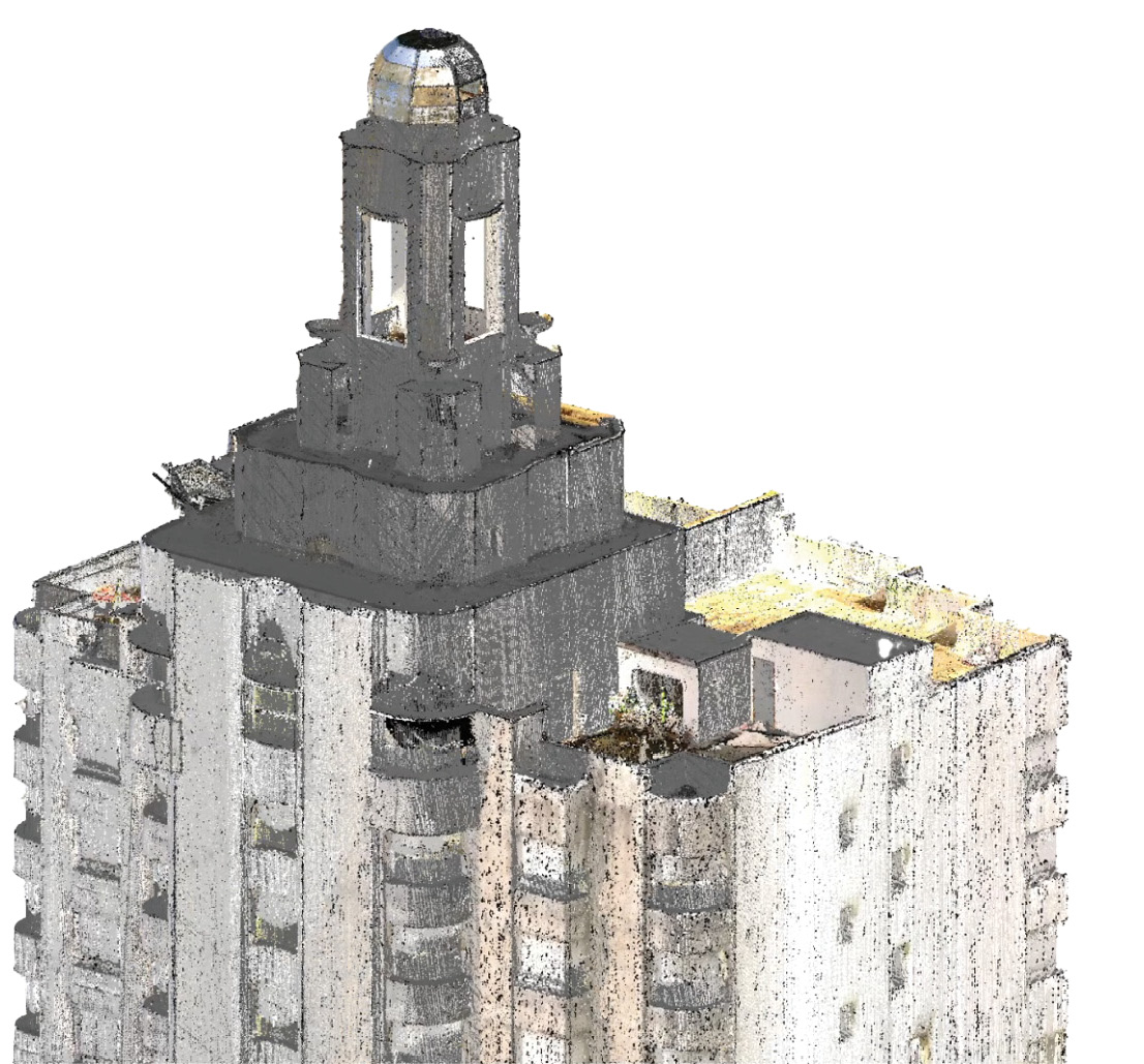
Figure 6: Dataset that combines UAV and terrestrial lidar for high-fidelity model creation.
Lukas moved on to a recent project in Palm Beach, a hotel that a developer was hoping to convert into a brand new, five-star hotel (Figure 6). Although only walls and cement floors remained, the client wanted to preserve as much of the original architecture as possible but wasn’t sure how much damage would be done by renovation. NV5 draped the image across the point cloud. Traditionally, BIM modeling has been based on terrestrial lidar, but a project like this is demanding—relative accuracy has to be really high, everything has to fit together really well, so tremendous detail is necessary for the modeling. NV5 did terrestrial lidar, therefore, then flew multiple passes at different elevations with a UAV and merged the airborne and terrestrial data. They admitted to some overkill, but the result was excellent, and they were able to create a model from it. Great satisfaction was derived from helping to preserve a historic building.
Mike noted that the client had been internal—a geotechnical group from an NV5 office in Florida, “people who go in and do everything with buildings”—so this ties back to the synergies mentioned earlier. Melissa thought that this sort of model could be used for real estate. A view of the ocean increases the price of a condo. Mike answered in a slightly different vein, “Let’s say we fly a dense area with considerable industrial activity to update the model with all the key components, e.g. propane tanks and shutoff valves. Terrestrial, UAV, mobile, you put them all together, you can model the update quicker. We’re getting into the emergency response world.”
Making GIS and utilities fit

Figure 7: Survey mark-outs can be safely collected from unmanned imagery, increasing safety and eliminating interruptions to traffic flow.
Lukas warmed to the theme of “fitting things together” and discussed orthorectified imagery. Lidar and imagery are collected independently, so Unmanned Systems do two separate flights, which takes a little more time, but are working on different solutions to fitting the imagery and lidar together. On top of control points and independent check points, this gives an additional independent check, so Unmanned Systems can compare lidar and imagery to ensure they are lining up perfectly. Lukas showed an example with underground utilities (Figure 7). The positions had been painted by the field crews, so that they avoided going into the middle of the road with total station and GNSS. They fly low with large numbers of overlapping images, so it is even possible to see underneath the vehicles for markings. They paint them as they locate them, i.e. the GIS is typically good to 10-20´, but the locator to a few inches.
Mark put this in perspective. It is a huge challenge to locate things below ground. Fifty or sixty years ago many clients didn’t know the location of their assets within 500´. NV5 has encountered instances of large 48-60 inch underground pipelines where a vegetation corridor was being mowed and vegetation management performed in a right of way that was different from where the lines were located! One of the firm’s most fascinating projects was in the southeast 24 years ago, involving gas pipelines from the Gulf. Mark explained, “We flew their pipelines and we found a four-week window during cold weather where you could clearly see the pipelines in normal black and white imagery. This evidence was from the warming of the lines from the pump stations located frequently along the lines. The pumping warmed the lines, resulting in healthy vegetation right over the lines, giving us near perfect locations of their underground infrastructure. We used this information to update their GIS and captured GNSS-based ground truthing in the field. The locations confirmed the new locations. Moreover, features in their GIS made perfect sense. Their encasement pipes fit perfectly under roads, their river weights6 fit under rivers and other bodies of water, and their digital twin took on significant added value.”
Electrical detail
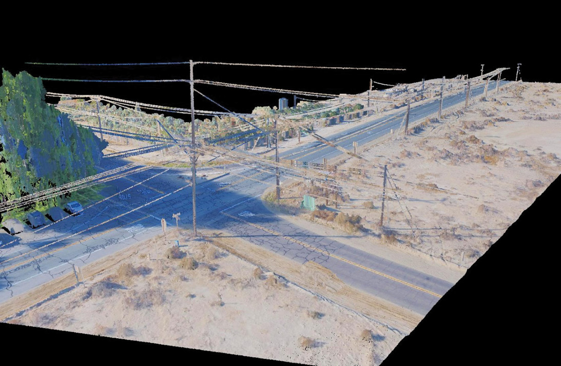
Figure 8: Lidar and imagery captured for both engineering and electrical design purposes.
Mike moved us on to the last example (a major US Air Force Base: Figure 8), in the utility space, one of the largest sectors in which Unmanned Systems is involved. “The great thing with UAV-lidar is that you can mobilize quickly to fit in with construction. We were flying so low with the RIEGL VUX-1LR that we got great detail not only on transmission lines but on distribution lines and service lines, even guy wires running down to the ground. Also, we were getting such high accuracy and level of detail on the ground that it saved considerable time back in the field.” He explained that this provided additional detail and reduced guesswork, because numerous features have to be identified in utility mapping and there are many features on each pole, so lidar reduces the guesswork. Unmanned Systems had received considerable feedback, especially internally from NV5 engineers who have been working in this space for a long time, and have used lidar from different sources, so really appreciate knowing that nothing’s going to be missed. Mike confirmed, “It’s good having experienced engineers in-house to talk to, who can look at Unmanned Systems’ work.”
Mike pointed out that all the features were classified. “Every client has their own preference as to features they want to see classified, but there are similarities between them and standards in the industry. Every utility has different requirements, but all the required features are classified.” Lukas added that Unmanned Systems was going to use the model in PLS-CADD (design software for overhead power lines), in which it was possible to try different loading conditions, different weather etc. Unmanned Systems collects weather at the time of flight. Using the data model, they can estimate what’s going to happen to the wire, how it’s going to sag under different loads, and how poles will be affected by adding a new pole down the line. They could export to PLS-CADD and figure out how the whole network was going to react. Unmanned Systems, therefore, take it up to a certain point, then hand it off to NV5 engineers, who can edit and do the rest of the work. They use the model started by Unmanned Systems for their final calculations. Mike summed up, “We deliver geographically/geodetically correct placement of all the assets, saved according to the weather at that time, and hand it off down the hall. They turn it into a design and construction package. Then we fly again later and do as-builts.”
And remember ground control!
Unmanned Systems always uses ground control points (GCPs). Mike said that transects, i.e. control points spread across the ground or walls of structures, are key and that his group is “well qualified when it comes to controlling lidar with UAVs.” He confirmed what many of us fear, “A lot of folks don’t understand that you can’t just strap an expensive lidar sensor on a UAV and everything is good to go. When I was training, I used a very simple way of thinking about control—think of pinning a sheet to the ceiling.”
Lukas’s perception was that the UAV industry earned a bad reputation early on for statements that GCPs were unnecessary and ridiculous claims such as centimeter or sub-centimeter absolute accuracy without control. Slowly, people started to set GCPs, but they would deliver RMS reports using the same points that they had used to control the imagery, i.e. re-use GCPs as independent check points. He pontificated, “You can’t do that. We took the approach that using UAVs isn’t different from using helicopters or planes. We still have to talk about accuracies and requirements, for example for QL1 or QL2 lidar. For terrestrial lidar, we do the transects. Relative accuracy has been questionable in the industry, especially early on. People would get their calculations of absolute accuracy correct, but for relative accuracy the estimates were so bad that the data wasn’t really useful. You should do some raster-based relative accuracy tests and statistical analysis on that, making sure that everything follows a normal distribution. Then, for density, again raster-based, make sure that 95% of the grid falls into the promised density range. These are not always used within the industry, but we’ve been using them for a long time. We wanted to take those things and apply them so that customers see the same reports and statistics regardless of platform. We wanted to be respected—and there are a lot of surveyors in this office, who look over our data with a fine-tooth comb! They wouldn’t let us get away with anything.”
Synergy is key …
Figure 9: Scott Kvandal serves as NV5’s chief synergy officer.
Mark took me downstairs to meet Scott Kvandal, NV5’s chief synergy officer (Figure 9). NV5 is a large company and has completed multiple acquisitions, so having an office to manage this synergy is key. Mark’s description was fulsome, “Scott is a really nice guy, really bright guy. He runs our synergy office. Remember that we are a little over 4000 employees strong.” Indeed. Scott obtained such high grades in his BS at San Diego State University that he won a full ride to Stanford for an MS in environmental engineering. He’s a professional engineer and has mixed a successful business career with missionary work in Paraguay. Mark met him at the interview prior to the acquisition of Quantum Spatial, when NV5 was conducting its due diligence. Scott covers synergies all across NV5, not just for NV5 Geospatial. He also runs NV5’s energy group. He summarized his role, “It’s just a matter of getting 45 or so acquisitions integrated and cross-selling. We’ve done pretty well but we can always do more, that’s for sure.”
… to building the future
NV5 is successful through both organic growth and multiple wise acquisitions. NV5’s Unmanned Systems group will play a growing role in the world of UAV-lidar, using the tool when and where it’s most suitable for a project, either on its own or in harness with TLS, MMS and airborne lidar from helicopters or manned aircraft. It will expand its autonomous lidar systems to surface vessels and robots on land. The dovetailing of Unmanned Systems and NV5 Geospatial into the overall NV5 operation reflects the company’s consciousness of and attention to synergies. The mission to maximize the value of acquisitions will be seen with Geodynamics very soon and others in the future7.
1 This was drafted before omicron.
2 Unmanned surface vehicle or unmanned surface vessel, i.e. travels autonomously on water surface.
3 Learn more at https://lidarmag.com/2021/04/01/setting-a-new-standard-for-topobathymetric-surveys/.
4 Ron Chapple is a contributor to LIDAR Magazine: https://lidarmag.com/2020/06/14/thought-leader-a-billion-points-of-light/.
5 Roe, G., 2019. NV5 provides integrated UAV lidar mapping services, LidarNews, 17 May 2019.
6 Natural gas pipelines have concrete added so they don’t “float” from their river crossing.
7 The pace has not let up: shortly after the visit, NV5 acquired PES Environmental.