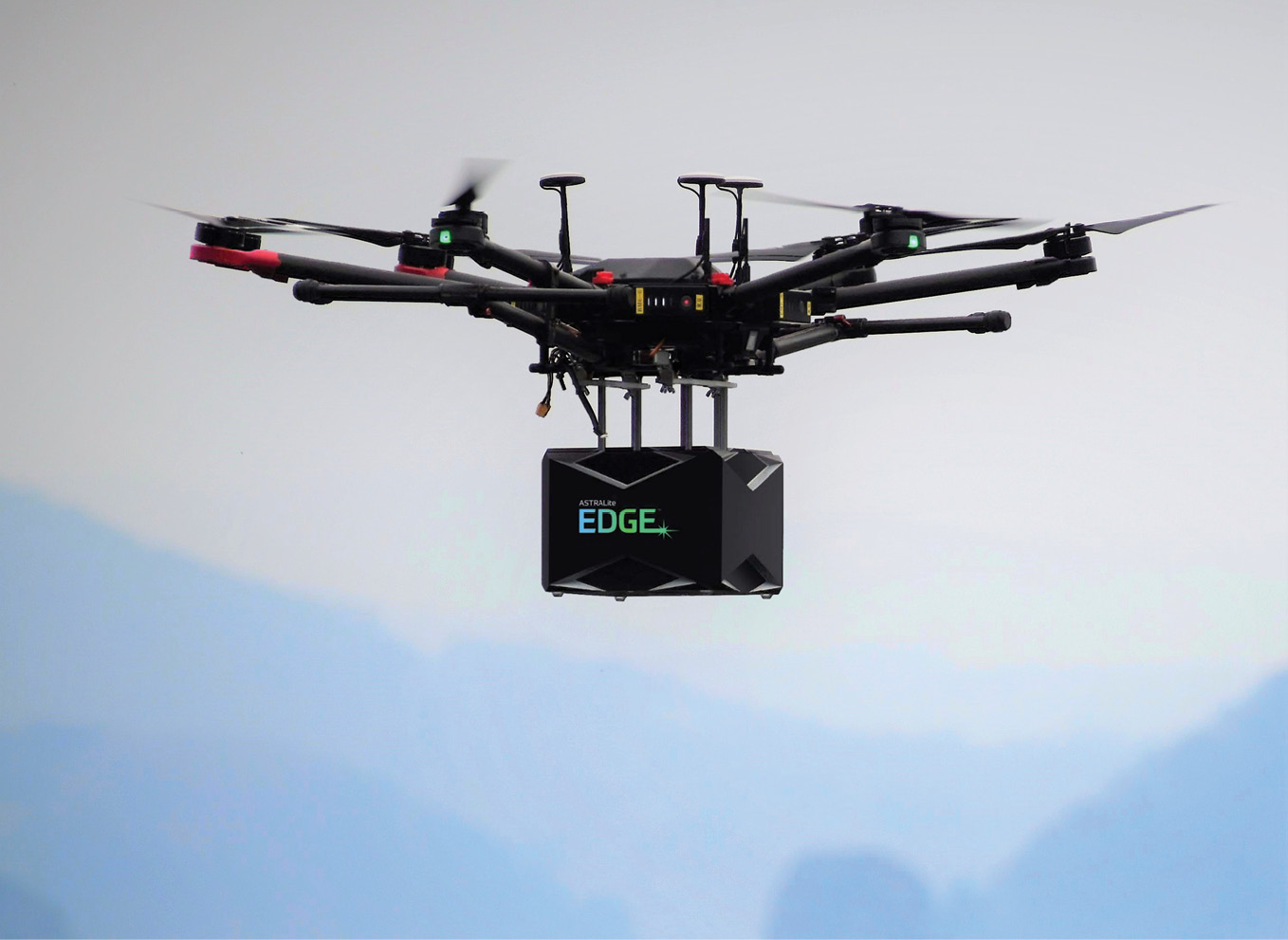
Figure 1: ASTRALiTe EDGE lidar sensor flying on a hexacopter sUAS.
Water is a vital resource for all cultures, and many people live, work, and play near the intersection between water and land. This resource has a powerful effect on our livelihood, but not always for the better. Over 300 million people reside in low-elevation coastal zones and are susceptible to coastal storms causing damages of tens of billions of dollars per year (Kron, 2013) with the expectation that the occurrence and severity will increase with increasing sea-level rise (Hinkel et al., 2014). From 2000 to 2018, costs associated with river flooding included $830 billion in economic losses and over 6200 deaths in the United States (Truhlar and Bergstrom, 2019). Coastal zones have complex bathymetry that can alter the dissipation of wave energy (Gomes et al., 2016) and create complex beach erosion and accretion events. These events represent dynamic and sometimes catastrophic change caused by the interaction of rivers, lakes, estuaries, and oceans with bounding land. Such interactions take place in critical shallow-water zones where a high fraction of aquatic bio-life, human-life activities, and infrastructure exist and, as a consequence, are altered.
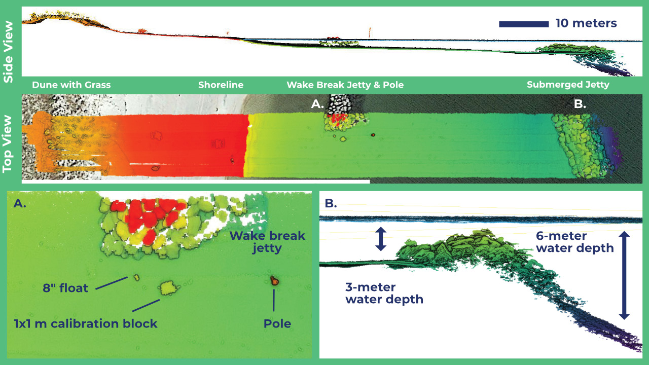
Figure 2: Multiple views of lidar data showing the dune crest covered in grass, through the shoreline transition, into shallow water, and along a portion of the jetty, some of which protrudes above the water line. Orange and red colors indicate above-water objects, while green to purple indicate increasing water depth. In the middle panel, the lidar data are superimposed on a photograph of the scene, showing the grass-covered dunes, the shoreline, the wake break jetty and pole. The tide was lower when the lidar data was collected, causing a slight mismatch between the satellite image and the lidar point cloud. The lower-left panel shows detail of some objects in the water, highlighting the high-resolution feature detection capability of the ASTRALiTe EDGE lidar.
Traditional topobathymetric airborne lidar systems have demonstrated the capability of mapping such regions and have served as a critical technology for understanding land-water interactions for several decades. These systems observe only a portion of the temporal-spatio spectrum of change, i.e., wide-area coverage with a few points per square meter resolution and infrequent revisits, typically measured in years.
Expanding our understanding of critical shallow-water zones and improving our ability to safeguard water infrastructure requires data at higher resolution and more frequent refresh rate. This is particularly relevant in cases where detecting and identifying weaknesses for small areas can prevent large-scale damage by implementing solutions prior to major disruptive events. A localized weak point in a levee, berm, dune, bridge pylon, or dam can lead to large-scale changes of a region or damage to infrastructure if not identified and repaired. When such damage occurs, repair and restoration procedures must be undertaken to prevent future issues; these operations require detailed and targeted maps of the affected areas. In particular, shallow waters exhibit dynamic bathymetry, with shifting currents leading to large changes in location of sediments, rocks, and other hazards.
The convergence of rapidly advancing technologies in lidar and in autonomously operated, uncrewed aircraft systems has opened up the possibility to expand the utility of topobathymetric lidar surveys into this more detailed temporal-spatio observing capability. The observing platform places constraints on the payload capacity and consequently requires miniaturization of the lidar system and supporting navigational components.
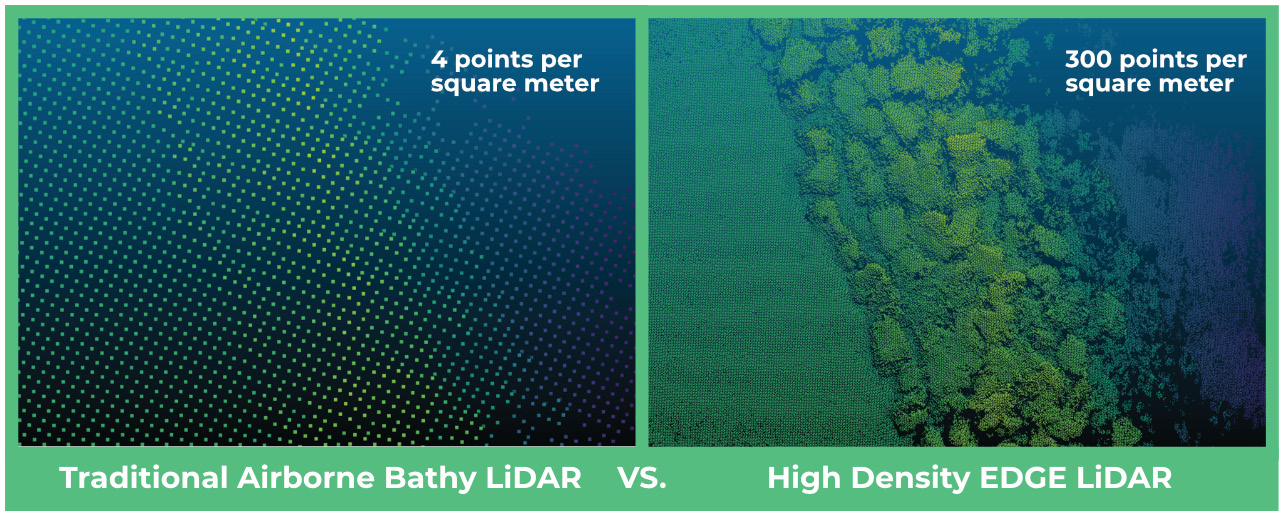
Figure 3: The comparison with traditional airborne bathymetric lidar, which has a typical resolution of single-digit points per square meter, demonstrates the high resolution of the ASTRALiTe EDGE lidar, which can resolve individual rocks. The water surface has been removed from the data for clarity.
To meet these demands, ASTRALiTe™, Inc. has developed the EDGE™ lidar, an ultra-lightweight scanning topobathymetric lidar system. EDGE is capable of mounting on above-water platforms to retrieve detailed geospatial information (>100 pts/m2) of land-water interfaces on a routine basis at much lower cost than traditional fixed-wing bathymetric flights. The lidar has unprecedented capability in 3D mapping of littoral-zone bathymetry with centimeter-level precision in waters shallower than 10 m. The system provides next-generation capability for day or night operations on a variety of platforms, such as watercraft or small unmanned aerial systems (sUAS), allowing for unique shallow-water capabilities (Figure 1). Eye-safety engineering control measures provide 3R laser light output, making the lidar beam equivalent to laser pointers sold in the United States. Preliminary data can be viewed immediately in the field upon return of the sUAS to enable rapid assessments of the surveyed area and of the data coverage1.
Three use cases are provided to demonstrate the ability of the ASTRALiTe EDGE lidar to survey infrastructure for change detection and remediation in the aftermath of damage.
Coastal use case—jetty
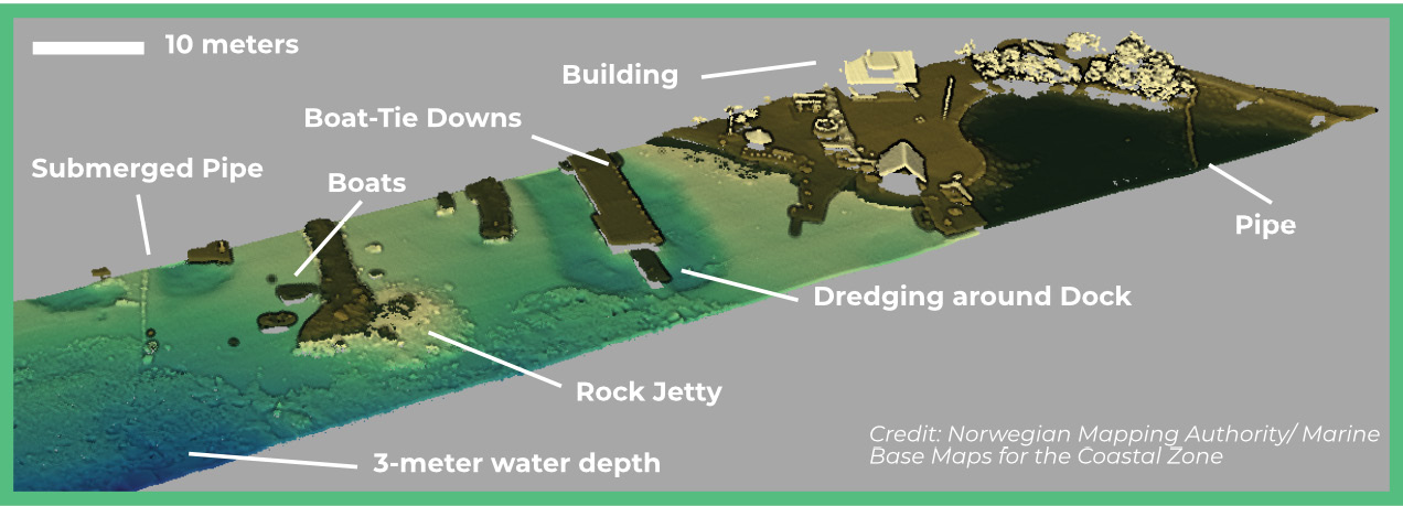
Figure 4: Lidar data from coastal Norway, with tan-brown indicating topographic features, and yellow-blue the bathymetry. Features shown in this set range from dredged areas around piers to individual rocks separated from a jetty, to a pipe running out to two harbor lights. Image courtesy of Norwegian Mapping Authority/Marine Base Maps for the Coastal Zone.
The first use case comes from Panama City, Florida, where a jetty protecting a beach was damaged by Hurricane Michael in 2018. In the wake of the storm, the jetty had become a navigational hazard to small boats and was less effective in protecting the shoreline from erosion and sediment transport. To prepare for remediation and repair of the jetty, a high-resolution survey was required to determine the location of displaced riprap, estimate the volume of relocated sediment, and identify underwater hazards.
The ASTRALiTe EDGE was deployed on a commercially available, multi-rotor (hexacopter) sUAS by Juniper Unmanned to survey a 10-acre area covering portions of the beach dunes, down through the land-water transition, and into water depths of 7+ meters. The deployment was quick and easy, requiring minimal coordination to secure the necessary permits.
The topobathymetric capability is evident in Figure 2, with the seamless transition from grassy dunes to 7-meter water depth. The high-resolution capability is illustrated by the significant detail in the jetty rocks captured in the lidar data (<5 cm resolution; Figure 3). Combined, these two features in the data highlight the benefits of using the AstraLiTe EDGE in such a survey. The high-definition lidar data was collected at 300 pts/m2 and was digitally georeferenced and classified to identify water surface, bottom, and land elements.
The data obtained from the survey shows precise locations and orientations of rocks and other hazards, providing remediation crews with knowledge to more effectively scope the effort required to repair the damaged jetty. Future work is scheduled to conduct a post-remediation survey to validate the completed restoration and assess whether it meets specifications.
Coastal use case—harbor
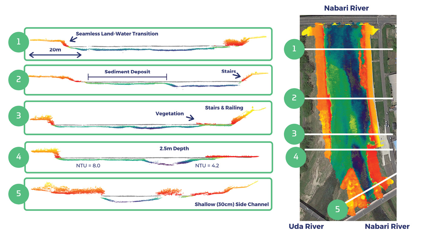
Figure 5: River transects and full map showing topography (red-orange) and bathymetry (green-purple) in a 5-acre area at the confluence of two rivers. Five transects include detail of stairs, vegetation, riverbank location, water depth, sediment deposition, and channel location.
Another coastal use case is inspection of jetties, piers, and navigational hazards off the coast of Norway. In particular, the local government required information on the status of a dredging project around two of the local piers, as well as the current state of an underwater pipe that provides power to two harbor lights (Figure 4). Flights were conducted by Nordic Unmanned AS using its Staaker BG200 drone, capable of carrying the lidar payload for 30+ minutes on a single battery charge.
The flight plans were designed to achieve 300 pts/m2 and cover 1.5 hectares per 15-minute flight, which enabled detailed depiction of the jetty rocks, many of which posed navigational hazards, because they had been displaced by waves. These rocks can now be recorded and tagged for removal/repair. Frequent surveys in this area will continue monitoring the status of jetty rocks, the 30 cm pipe, and the dredged area surrounding the piers, providing valuable insight for harbor authorities.
River use case
The third use case is a riverine survey on the Nabari River in Japan. Infrastructure surrounding the river is protected from high river flow rates by levees and other bank cladding strategies. Local governments require frequent inspections of river systems that experience dramatic change as a result of destructive typhoons and seasonal flooding. These flood events can cause significant sediment transport and deposition, damaging infrastructure such as bridges and levees.
Resource managers require up-to-date information on the state of the river and how to remediate effects of the previous storm event. A drone-based high-resolution survey of the area using the ASTRALiTe EDGE provides tactical data on specific problem areas, such as bends, confluences, or critical infrastructure, including the underwater portion.
Lidar data captured by Mirukuru Co. Ltd. indicated that sediment had built up at the confluence of these two rivers, primarily at the output of one of the side rivers (Figure 5). This was deposited on the left side of the river channel (shown in overhead view as shallow green area). Near-real-time visualization allowed for quick, actionable decision-making and strategic revisits to areas of interest. The flight altitude above ground level was 30 m, the sUAS traveled at 4 m/s and the river’s turbidity was measured at 4-8 Nephelometric Turbidity Units (NTUs).
The data extracted from the 3D point cloud includes cross-sections of the river, encompassing water surface, water bottom, vegetation, land, and man-made objects such as stairs and rails. Waters as shallow as a few centimeters are observable and vegetation near the water’s edge is clearly distinguishable. The ASTRALiTE EDGE provided seamless transitions from land to water and measured depths of 2.5 m in this river system when the Secchi depth was estimated to range from 0.8 to 1.4 m.
Summary
The new standard for topobathymetric lidar is a more detailed, more frequent set of observations in land-water transition regions that can be deployed at dramatically lower costs. These measurement attributes enable users to improve planning and prevention efforts, and/or repair and restore damaged areas – whether environmental or man-made. The ASTRALiTe EDGE offers this capability and places highly coveted, detailed data in the hands of users, as shown in the examples above, to enable rapid and targeted investigations, including maintenance and restoration operations. Surveyors can use this innovation of topobathymetric lidar in combination with sUAS to work in areas that are difficult for boats or divers to reach, rapidly assess the data, and increase the frequency of surveying areas of interest to dramatically improve the effectiveness of data products for their customers.
For example, underwater infrastructure can be more easily evaluated than with current methods (diver, sonar), facilitating a more informed situational assessment. The generation of highly detailed maps enables change detection assessments at centimeter levels and captures this change on short timescales rather than the hydrographic “climatological” scale of past airborne topobathymetric surveys.
The convergence of lidar and sUAS technologies combines previously unavailable high-definition topobathymetric lidar data with increased flexibility of data acquisition, resulting in dramatically improved decision aids for end users who must adapt to the ever changing, dynamic environment where land and water meet. Users are just beginning to learn how best to implement the new capability for a variety of use cases like the ones shown here.
Andy Gisler is director of lidar at ASTRALiTe and leads the research and product development programs. He has over a decade of experience working with laser systems and spearheads the development of the EDGE lidar system.
Dr. Jeffrey Thayer is CTO of ASTRALiTe, is the inventor of the patented techniques used in the EDGE, and has over two decades of lidar experience. He is also a professor of aerospace engineering sciences at the University of Colorado.
References
Gomes, E.R., R.P. Mulligan, K.L. Brodie and J.E. McNinch, 2016. Bathymetric control on the spatial distribution of wave breaking in the surf zone of a natural beach, Coastal Engineering, 116: 180-194. 10.1016/j.coastaleng.2016.06.012.
Hinkel, J., D. Lincke, A. T. Vafeidis, M. Perrette, R. J. Nicholls, R. S. J. Tol, B. Marzeion, X. Fettweis, C. Ionescu and A. Levermann, 2014. Future coastal flood damage and adaptation costs, Proceedings of the National Academy of Sciences, 111(9): 3292-3297, March 2014. DOI: 10.1073/pnas.1222469111.
Kron, W, 2013. Coasts: the high-risk areas of the world, Natural Hazards 66: 1363–1382. .
Truhlar, A. and C. Bergstrom, C., 2019. Surging waters: science empowering communities in the face of flooding. American Geophysical Union, Scienceisessential.org.
1 Visit www.astralite.net for more information.