
The spring 2021 FL-ASPRS/UF Lidar Workshop was held remotely on 17 June 2021 and attended by 140 participants. While the majority were from the US (Florida, Georgia and California), other ASPRS registrant countries included Canada, Pakistan, and Brazil. The seven-hour workshop contained recorded technical and application-oriented presentations by state and federal agencies, academia, and private industry. Presenters were available to answer questions live. USGS’s Dr. Warren Day, Earth MRI (EMRI) Science Coordinator and Research Geologist, presented the keynote session live and fielded questions about the EMRI program. The biannual workshop was the Florida region’s 10th in the series. The plan moving forward was to run a hybrid live/virtual Fall workshop in October 2021.
Editor’s note: See the article (PDF) as it appeared in the magazine, for graphics.
The workshops traditionally begin with representatives of the five Water Management Districts—Northwest Florida (NWFWMD), South Florida (SFWMD), St. Johns River (SJRWMD), Suwannee River (SRWMD) and Southwest Florida (SWFWMD)—giving short presentations detailing either their recent lidar and/or imagery acquisitions or issues that they have encountered.
Additional state and/or federal agencies also have the opportunity to present. For the spring 2021 workshop, agency briefings were provided by: Florida Department of Revenue (FDOR); Florida Department of Environmental Protection (FDEP); US Geological Survey (USGS); and Dewberry, briefing on the on the Florida State Lidar program.
In 2018 Florida Division of Emergency Management (FDEM), Florida Department of Transportation (FDOT) and the five Water Management Districts entered into a cooperative program with USGS to remap 34,000 square miles of the peninsula of Florida to the USGS QL1 specification. Then, following Hurricane Michael in 2019, USGS authorized remapping of the central panhandle of Florida. The acquisition and processing of the lidar data were discussed in the Dewberry briefing.
NWFWMD
Jesse Gray, a recent addition to the NWFWMD staff who manages all of the District’s lidar acquisitions, described the previous lidar collections in NWFWMD. He noted the continuing challenge of obtaining lidar data in the Eglin Air Force Base airspace, indicating that the area was mapped by earlier acquisitions at the QL2 level. He concluded by illustrating the 2020 USGS QL1 post-Hurricane Michael lidar acquisition currently in progress (Figure 1).
SJRWMD
Sandra Fox contributed a map showing the status of SJRWMD’s review of the current USGS/FDEM Peninsular lidar (Figure 2). Most of the coastal counties in SJRWMD have been reviewed, while the inland counties are awaiting review.
SRWMD
Paul Buchanan, GIS Manager, reported on the lidar remapping for Gilchrist and Bradford counties and a topobathymetric (CZMIL) project in the Suwanee Sound area (Figure 3). He also presented SRWMD’s 360º image mapping project of the Suwannee River and its primary tributaries, known as the Riverview Project (Figure 4).
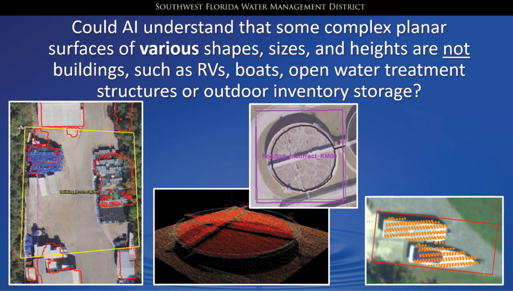
SWFWMD
Nicole Hewitt cited a discussion with James Van Rens in the Spring 2021 issue of LIDAR Magazine1 regarding the future of artificial intelligence (AI) in lidar processing. Nicole presented several “challenges for classification”, including building misclassifications as well as bridge and seawall misclassifications, which could potentially be resolved through AI coupled with high-resolution orthophotography and/or oblique imagery (Figure 5).
FDOR
Charles Russell contributed a map showing the orthoimagery acquisition scheduled for fall 2021/winter 2022 and the links to the FDOR website for the Florida orthoimagery standards and tile index (Figure 6).
FDEP
Parker Hinson represented FDEP and the Florida Geographic Information Office (FGIO). He discussed two major FDEP/FGIO updates, including the newly announced Coastal Mapping Initiative (CMI) (Figure 7), as well as additions to the FGIO Hub (floridagio.gov) (Figure 8). CMI will assist State efforts in mapping Florida’s coast using topobathymetric lidar, and updates to the FGIO Hub include new partners, content, and lidar projects and resources such as the Florida Peninsular LiDAR County Delivery Dashboard.
USGS
Alexandra “Xan” Fredericks provided an update on behalf of the National Geospatial Program about the 3D Elevation Program (3DEP) and the FY2021 Broad Agency Announcement. She displayed several new features and datasets available on the USGS/The National Map (Figure 9) and illustrated how to use the webmaps for planning and coordination of topographic and topobathymetric efforts in Florida, as well as the Florida Coastal Mapping Program Hub (Figure 10).
Florida Statewide Lidar
Elise MacPherson presented the Florida Statewide Lidar Mapping Project on behalf of Dewberry. She started with an overview of the Florida Peninsular Lidar Project, then discussed the challenges and issues encountered (Figure 11). She outlined problems with calibration, classification, and breaklining, along with the complexities of having multiple data collectors, compilers, and multiple levels of external review. Since October 2020, 29 (out of 34) counties’ QL1 lidar data has been delivered. Moreover, lidar collections of the northern counties, which were delayed owing to flooding and calibration issues, have been conflated and are in final stages of completion by dedicated staff.
With more counties nearing completion, edge-matching has been a continuing challenge. Marion County, which borders on seven other counties, has been particularly problematical, but, thanks to past experience, these issues are being resolved.
She concluded with a description of the review process, the project status map (Figure 12) and an updated project completion schedule.
Emily Klipp completed Dewberry’s presentation by discussing the status of the Florida Hurricane Michael Project (Figure 13). She summarized the damage resulting from the hurricane and the rationale for the USGS Supplemental project. The QL1 lidar collection was accomplished by the end of February 2020, but flooding along the Apalachicola River, combined with covid-19 restrictions in early 2020, delayed acquisition in the area until late April 2021.
Emily ended with an update map of the Hurricane Michael Supplemental Project (Figure 14).
1 Walker, S., 2021. The next decade with lidar: LIDAR Magazine interviews James Van Rens, SVP, RIEGL USA, LIDAR Magazine, 11(1): 12-16, Spring 2021.