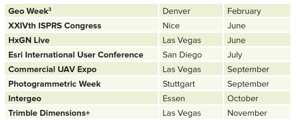
Sometimes I wonder, sitting in my office enjoying the sunset through the California palms, whether it is such a blessing to be back on the road. Those words, of course, belt out the name Kerouac. His view was, “They have worries, they’re counting the miles, they’re thinking about where to sleep tonight, how much money for gas, the weather, how they’ll get there—and all the time they’ll get there anyway, you see.” I don’t think he meant the frequent flyer miles or hotel points. I’ve written on our digital site about my travels in the Bay Area1 and to Redlands for the Esri Imagery Summit2. I have another trip in the making before the end of the year, but, like many readers, I’m eagerly anticipating the big events of 2022 and hoping they take place face-to-face or hybrid:
I won’t rewrite my piece on the Esri Imagery Summit here. Suffice it to say that it was two intense days of well-prepared presentations and discussions. The audience was an eclectic group of 80 with around 1000 remote. It crossed my mind that the sparse audience in the beautiful auditorium in Esri’s Q building (which reminded me of the lecture hall in Stuttgart used for the Photogrammetric Week, with its brutalist juxtaposition of wood and concrete) encouraged more uninhibited questions than if it had been full; we forgot that also listening was a big online audience! While the program included numerous updates from Esri experts, the enduring take-home is the daunting role that we geospatial folk are destined to play as we try to save our planet. We are now sitting at the “adult table”, i.e. we’ve come beyond being enablers through the supply of geographic information—we have to do our utmost actually to engineer change. There is consensus also—and, as I write I am reading headlines about the goings on at COP26 in my home city of Glasgow (typical November days there, unfortunately, don’t bring global warming to mind)—that the broader world agrees with Jack Dangermond when he said, at the end of his plenary at the 2021 Esri International User Conference, online, this summer, “It’s late in the day, but not dark yet”. If we act responsibly and fast, we can probably turn things round. There will be terrible depredations as climate events intensify for years to come, but the planet and the human race will survive. Or, indeed, we could call it a day and continue to indulge our love of fossil fuels and various environmentally unfriendly foods and beverages…
The ability of this magazine to bring you up-to-date, relevant articles about lidar and its applications continues to draw on a fruitful relationship with ASPRS. We give opportunities to presenters at ASPRS events to publish with us if they don’t want to go down the peer-reviewed route offered by Photogrammetric Engineering & Remote Sensing. There is an excellent account in this issue of a new sensor from Leica Geosystems (part of Hexagon) by ASPRS president Jason Stoker and colleagues from USGS, USFS and the Department of Agriculture. This was first given at the online ASPRS 2020 Annual Conference. Charlene Sylvester of USACE enlightens us on mapping the shorelines of the Great Lakes, a presentation first given at a meeting of the ASPRS Eastern Great Lakes Region event entitled “Technology Impacts: What’s Next in Mapping?”. Thirdly, Al Karlin’s article is a backgrounder to and synopsis of the first session of the spring Lidar Workshop given jointly by the ASPRS Florida Region and the University of Florida, the 10th instantiation of this event. This took place in June and further articles are in the pipeline. Since then, these organizers have run both a SAR and the 11th lidar workshop. We have articles from the former being processed and from the latter, being solicited.
We have two articles on very different lidar sensors. Christopher Dollard from Leica Geosystems describes a real-estate application of the Leica BLK2GO handheld laser scanner. Matt Bethel and Andrew Moller recount the experiences of a joint venture of Merrick and Surdex flying the Teledyne Optech G2, a combination of two Galaxy high-end topographic lidar sensors in the same crewed aircraft.
We round off the issue with an article from Charlie Magruder and Matthew Harman of Esri, which gives an overview of the state of the art in precision agriculture with a focus on sustainability. We hope that this is the first of a long series of articles from Esri and its customers, several of which are already being planned.
I want to say a word of thanks to our regular contributor Lewis Graham. How he finds time to contribute something of substance to every issue of this magazine while fulfilling his duties as president and CEO of GeoCue remains a mystery to me, but we’re certainly grateful to him. In this issue, he addresses the problem of satisfactorily characterizing the comparative performance of different UAV-lidar sensors.
As always, I like to end with something from the press. In these troubled times, it’s not inappropriate that the setting is defense. The US Army, it is reported4, is spending $22b with Microsoft to equip soldiers with augmented reality goggles, a ruggedized version of the Hololens with significant enhancements. Naturally, there is a FLA (four-letter acronym): IVAS (Integrated Visual Augmentation System). The user will see intelligence information projected into the field of view and the system will remain “locked to the real world”, because it is also equipped with sensors to detect the surrounding environment. Center stage are lidar and machine-vision software that perform the operation within the seven milliseconds before dizziness sets in. It’s impressive—and other military agencies are looking hard at it. What will be next—contact lenses? Meanwhile, but not yet on sale in the US, Chinese automakers are proud that their new models have built-in lidar sensors5. More on automotive lidar developments soon.
Recently we published Howard Butler’s fine obituary of Martin Isenburg6. We hear, thankfully, that interested parties are in talks to try to continue the activities of Martin’s company, rapidlasso GmbH, so that his customers’ needs are met and the priceless intellectual property he left behind is preserved and used. The strength of the lidar community shines like a lighthouse.
1 lidarmag.com/2021/09/14/green-green-my-valley-now/
3 One of the highlights of Geo Week will be the presentation of the Lidar Leader Awards. See gisuser.com/2021/09/2022-lidar-leader-awards-program-announced/
4 Anon, 2021. The future of warfare: through a shimmering looking glass, The Economist, 440(9264): 69-70, 25 September 2021.