For this installment of Quick Takes, we discuss the commercialization of synthetic aperture radar (SAR) with Dr. Joerg Herrmann, Senior Vice President, Special Projects, Capella Space. This reflects LIDAR Magazine’s interest in technologies that are complementary to lidar in determining elevation and elevation change.
LM (Dr. Stewart Walker, Managing Editor): Joerg, you and I first met when you were with Airbus and I was with BAE Systems. Can you please tell us something about yourself and what prompted your move to Capella Space. What is your role in the start-up company? You had to move to San Francisco to fulfill your new role – has that been fun?
JH: Working at one of the world’s largest aerospace and defense companies taught me a lot about building space systems and working with the government, but to fully realize my career-long dream of commercializing synthetic aperture radar (SAR), I knew I needed to be at a company that could move quickly and be agile. Silicon Valley is unique in that there is great enthusiasm to apply breakthrough technology to transform major industries using new and unconventional approaches while also generating commercial returns. This creativity gives us an incredible opportunity to build the future of commercial space.
When I met Capella Space CEO Payam Banazadeh a couple of years ago, it was clear he was building something really powerful and that we share the same mission of disrupting how SAR is being used. I saw for the first time a tangible path to achieving what I always believed would be possible with SAR technology.
In the late 1990s, I proposed the commercialization of SAR remote sensing in collaboration with industrial and institutional partners in Europe and North America, which resulted in the TerraSAR program. At that time I served as founding CEO of the TerraSAR-X operating company Infoterra, and to ensure legal security for the service’s business case, I requested data security legislation in Germany.
LM: Please tell us about the founding of Capella Space and the other senior leaders in the company. From the website, it is clear that Capella Space is blessed with a hugely talented and experienced leadership team.
JH: When Malaysia Airlines Flight 370 went missing in 2014, Payam was shocked by the lack of visibility into our planet and frustrated that rescue teams couldn’t find the plane. Given all of the advanced technologies for monitoring activity on Earth, how could a plane just disappear? This event was the catalyst for Capella Space and inspired him to help people and companies make better decisions through on-demand SAR data.
Capella has assembled a stellar team of industry veterans committed to delivering on the promise of real-time Earth observation. We have deep domain expertise across a wide array of verticals—military, aerospace, geography, computer science, etc.—but we share a common goal of realizing Capella’s vision for a world empowered by SAR satellite data.
LM: How did you decide on the name “Capella”? I’m very excited about this, especially since I attended a concert by Out of the Blue, the world-famous Oxford a capella singers, at the Edinburgh Fringe Festival this summer!
JH: Nothing to do with a cappella, I’m afraid! We took our name from a close, non-eclipsing binary star that is the brightest yellow star in the sky. The star is made up of four components that never block one another when seen from Earth (just like how our SAR constellation will never be “blocked” from seeing the planet by clouds or nightfall). The name Capella means “the little goat” in Latin. In Greek mythology, the star represents the goat whose broken horn became the cornucopia, a horn of plenty which could be filled with anything its owner wished for. We believe that one day soon Capella’s information will do the same for many clients.
LM: How is Capella Space funded? Is it venture capital?
JH: Yes, we are venture-financed and recently received additional funding to complete our first operational seven-satellite constellation launch in 2020, with significant backing from multi-billion-dollar funds DCVC (Data Collective) and Spark Capital.
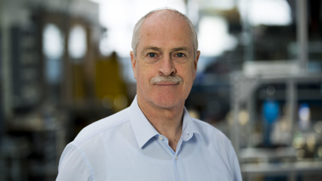
Dr. Joerg Herrmann, Senior Vice President of Special Projects at Capella Space.
LM: LIDAR Magazine’s readership is not expert in synthetic aperture radar, so please try to answer the next few questions as clearly as possible and without equations! First of all, what was the opportunity that you saw when you founded Capella Space? What can you do, using smallsats, that existing providers such as Airbus and Maxar cannot?
Also, UrtheCast is planning its OptiSAR constellation, for which the first launch comes quite soon. Then there is XpressSAR, i.e. perhaps you are part of a trend towards smallsat SAR. So far, however, the SAR constellations that are actually flying are traditional, large, heavy satellites, whereas your plan is based on smallsats – why do you think that is?
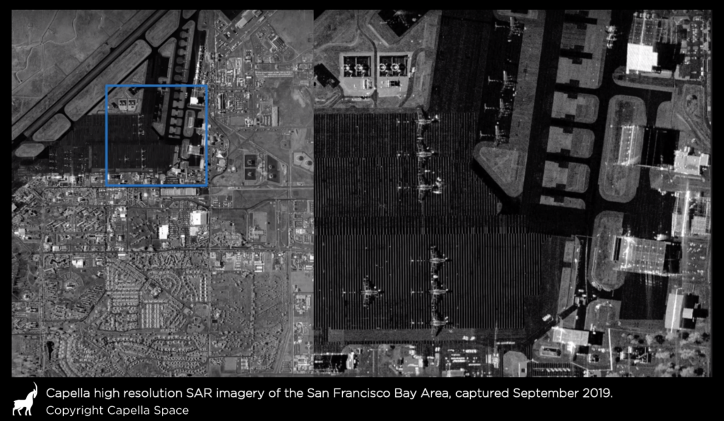
JH: Capella is the first private U.S. company to develop small SAR satellites for the commercial market, and we’ve made an effort to design a satellite system that is the quickest and most cost-efficient to scale. Our satellites are less than half the size of other SAR small satellites, and thirty times smaller and hundreds of times less expensive than traditional SAR satellites. Capella has optimized the satellite manufacturing for cost and schedule, and will in the next step optimize for output and cadence. Our SAR sensor design abstains from the widely used flat antenna approach, either with slotted wave guide or active phased array, which can be schedule driving, but it capitalizes on high performance components ensuring great image quality. Our supply chain is lined up, and our facilities are extended to reach the capacity for assembly, integration and test of 12 spacecraft per year in 2021. All these strategic decisions and actions mean that we can launch more satellites faster, on far fewer rockets and with significantly less capital than any other company.
Our first wave of operational satellites will set a new technological standard for the industry by featuring sub-0.5 meter very high resolution (VHR) to capture images of unparalleled quality. But not only that—the new constellation will also achieve a high energy efficiency that enables an impressive imaging capacity and flexibility through a collection time of up to 10 minutes every orbit, which is five times better than other small satellite competitors. Combined, the advances mean Capella will deliver more higher-quality images in less time than anyone else in the industry. We are focusing on high image quality paired with a high level of timeliness.
LM: Please tell us about your constellation – the satellites themselves, the SAR sensors, the orbits and the planned schedule of launches? What are the big features of the Capella Space solutions, for example resolution, revisit time, or ease of tasking?
JH: The Capella constellation of 36 satellites will be placed in 12 orbital planes to provide hourly revisits of any point on Earth. All satellite operations, from scheduling to product delivery, will be automated, and the constellation schedule will be constantly updated to support on-demand acquisition requests. In addition, each satellite will be operated under orbit control conditions that meet the needs of good quality interferometric SAR data collection, with an interferometric repeat time as short as 4 hours.
Capella’s technology makes it the first company in the industry to capture truly sub-0.5m VHR imagery. What’s more, Capella entered into industry-leading agreements with Inmarsat and Amazon Web Services (AWS) to task satellites in real-time and rapidly deliver frequent, timely and flexible SAR data via the AWS Ground Station network. As a result, Capella is the first and only Earth observation company to offer real-time SAR, where we will accept requests, task our satellites in real-time, then deliver imagery to customers within, on average, 30 minutes of collection. Government and commercial markets increasingly demand this type of real-time data, which has driven Capella’s customer growth. We recently announced government customer wins—U.S. Air Force and National Reconnaissance Office—and booked contracts with multiple other organizations across key industries.
In early 2020, Capella will launch its first operational satellite, Sequoia, followed by the launch of six additional satellites throughout the year. Sequoia will be deployed from Cape Canaveral into a polar sun-synchronous orbit by Space X. The miniaturized SAR sensor that will fly on Sequoia is a significant upgrade from the radar tested on our previous satellite, Denali, and it has been successfully tested on multiple airborne campaigns. After Sequoia, three more satellites will go up in June on the Indian PSLV launch. Three additional satellites will then be going up in Q3 or Q4 2020, forming the complete Whitney constellation.
With the advancement of Capella’s innovations in satellite technology, VHR SAR imagery, and on-demand Earth observation data, 2020 will be a momentous year for Capella, its customers, and the commercial space industry.
LM: What are the advantages and complementarities of SAR imagery, with respect to the much more familiar multispectral imagery available from constellations such as DigitalGlobe, Airbus and Planet?
JH: SAR functions independent of weather and sun illumination, which is a precondition for reliable, cloud-free and persistent monitoring. Through hourly revisits over any hotspot on the globe, this ensures excellent insights into patterns of life and any changes that matter to a customer.
Besides that, SAR is able to measure distances with extreme precision and, like lidar, can be used to measure topography and 3D structures. Location accuracy of SAR imagery can be significantly higher than optical camera systems typically achieve. Also, the automated analysis of surface motions with millimeter accuracy is a capability very specific to SAR. Change detection analytics based on SAR measurements have proven to be a reliable tool, and by adding AI, the utility of our monitoring frequency will make hotspot monitoring much more efficient and reliable.
LM: Now the big question for lidar people! Please explain a little about differential InSAR, coherent change detection and all the wonderful things that SAR can do in Z and ΔZ.
JH: SAR can be used to determine digital elevation models, either by radargrammetry (stereo, like photogrammetry) or by interferometry. Across track interferometry may be most comparable to a “stereo view”. Repeat pass interferometry implies that you take a second data collection with the same observation geometry next time your satellite flies over the same area. This method is used for coherent change detection, and the changes you can detect correlate to the wavelength of the spectrum being used. In the X-band spectrum that we and many other systems are using, this is in the millimeter range. If the resolution is sub-metric, it is possible to detect a footstep in sand or grass that was not there before. If you build a collection of time series data over an area with expected dynamics, you can measure the “breathing” of the earth’s surface over an oil or gas production field or measure even minute-by-minute changes on critical infrastructure such as a bridge, pipeline or dike.
Meanwhile, scientists have also optimized the atmospheric correction in radargrammetry measurements, so that ground control points can be measured from space with geodetic accuracies in the centimeter range.
LM: Your plans are a lot more than a dream, are they not? You already have a pathfinder mission in orbit. Can you please tell us something about that? Also, when I heard you speak at the Pecora 21/ICRSE 38 conference in Baltimore recently, you said that you were integrating a satellite for an imminent launch. How did that go?
JH: We have reached what our engineering experts refer to as a “very high level of compaction” in our design—we have significantly reduced the size of our spacecraft while maximizing performance. In essence, we pack enormous performance into a very small volume. Development risks have been mitigated with our pathfinder mission last year. Our micro-SAR sensor, which capitalizes on insights learned from the Denali mission, is currently being used in airborne campaigns to optimize the processing and calibration of the sensor system. We can launch the next satellite, Sequoia, with confidence early next year, knowing we have a high level of technology readiness on board and on the ground, in addition to validated automation of our mission operations.
LM: When we met during Intergeo in Stuttgart in September, you said that the mission control aspects will be very automated. Could you say a little more about this and explain how this differs from other constellations, please?
JH: Operating a large satellite constellation benefits from a high level of onboard autonomy, as well as automation of the end-to-end operations. While traditional satellite missions often depend on a ground operations team, we have prepared our system to operate autonomously over a wide range of operating scenarios. This is essential for cost-efficient and conflict-free operations of the fleet, and for meeting customer requirements with the real-time capability we are offering.
LM: Moving more to the downstream side, could you say more about data download, processing and distribution? What is Capella Space doing in these areas that is particularly exciting?
![]() JH: We recently entered into an exclusive agreement with Addvalue, a one-stop digital, wireless and broadband communications technology products innovator, for use of its Inter-Satellite Data Relay System (IDRS™) via Inmarsat’s global L-Band satellite communications network. Inmarsat is the leading global mobile satellite communications provider. The partnership gives Capella a significant market lead as the only SAR provider with real-time tasking capability and positions Capella as the only SAR operator capable of real-time responsiveness. This constant contact with the fleet via Inmarsat’s network of communications satellites will reduce the time it takes to order and deliver VHR Earth imagery from hours to minutes. This makes Capella the first and only Earth observation company that can accept and task its satellites in real-time, making it virtually latency-free. Capella will accept and task its constellation in real time and deliver imagery to customers within on-average 30 minutes of collection. As the industry average from order to delivery is typically eight hours and can be as long as several days, Capella will provide satellite imagery more than 16x faster than the industry average.
JH: We recently entered into an exclusive agreement with Addvalue, a one-stop digital, wireless and broadband communications technology products innovator, for use of its Inter-Satellite Data Relay System (IDRS™) via Inmarsat’s global L-Band satellite communications network. Inmarsat is the leading global mobile satellite communications provider. The partnership gives Capella a significant market lead as the only SAR provider with real-time tasking capability and positions Capella as the only SAR operator capable of real-time responsiveness. This constant contact with the fleet via Inmarsat’s network of communications satellites will reduce the time it takes to order and deliver VHR Earth imagery from hours to minutes. This makes Capella the first and only Earth observation company that can accept and task its satellites in real-time, making it virtually latency-free. Capella will accept and task its constellation in real time and deliver imagery to customers within on-average 30 minutes of collection. As the industry average from order to delivery is typically eight hours and can be as long as several days, Capella will provide satellite imagery more than 16x faster than the industry average.
LM: What products will you make available to end-users?
JH: We will roll out a portfolio of products next year, starting with high resolution, frequent revisit SAR data, and then add data stacks for interferometric and change analysis triangulation and monitoring services.
LM: Is there anything unusual or novel about your business model, in terms of pricing, subscriptions or other payment schemes? What is the platform that you mentioned at Pecora 21/ICRSE 38?
JH: We are giving our customers and partners access to our API via our online platform, the Capella Console. Customers can subscribe to services, and our pricing will be very competitive.
LM: What do you expect to be your main markets? Do you think Capella Space will be a defense contractor, with a few commercial clients as well? Some people have said that it is impossible to make money from spaceborne earth observation without massive defense purchases – what do you think?
JH: Defense and intelligence are a key market, of course, but both government and commercial markets are increasingly demanding this type of VHR real-time Earth observation data. We’ve recently secured major contracts with multiple divisions of the U.S. government, including recent contracts with the U.S. Air Force and the National Reconnaissance Office, and are also working with customers across multiple other use cases, including insurance, disaster management, oil and gas, urban development and maritime. We value our commercial clients and see numerous opportunities to democratize access to SAR outside of defense and intelligence.
LM: As a result of your choices of hardware and software technologies, and the various technical and business innovations that you are accomplishing, do you expect some new customer groups who will use SAR differently from how data from the existing constellations is being used?
JH: Absolutely. Capella is committed to helping provide more people with access to SAR data. We recently launched the Capella User Community, which gives members free access to Capella’s SAR data. In exchange for feedback and results of their projects, these users can explore different applications to solve some of our world’s greatest problems—from natural disaster response and city planning to illegal fishing monitoring.
We also recently announced a partnership with SpaceNet, a nonprofit organization dedicated to accelerating open source, artificial intelligence (AI) research for geospatial applications.
The goal of these programs is to expand awareness and use of SAR data to encourage experimentation and help uncover new applications for using this technology—we’ve only scratched the surface of what’s possible.
LM: Finally, a couple of very speculative questions. Do you have any thoughts about Capella Space doing a multispectral or hyperspectral constellation once the SAR is up and running? And do you think there is any possibility of spaceborne lidar using smaller satellites like yours?
JH: Space-based lidar is being used to measure wind, cloud and aerosol profiles, and to assess topographic data on the Earth’s surface (for example, ICESat-2). These missions are still rather heavy and power-hungry. Multispectral constellations are emerging, while hyperspectral is also coming out of smaller satellites. The next few years will reveal how these remote sensing techniques can find a role in developing the world of microsatellite constellations.
Dr. Herrmann, thank you very much indeed. LIDAR Magazine is very grateful to you for taking the time to answer our questions. We look forward to news of your various launches and the forthcoming SAR products.
______
Joerg F. Herrmann is Senior Vice President of Special Projects at Capella Space Corporation. He previously served as senior business development executive at Airbus Defence and Space. He initiated the commercialization of synthetic-aperture radar (SAR) satellite remote sensing in Germany through the TerraSAR program and served as founding CEO of the TerraSAR-X services entity, Infoterra.
During his more than 30 years in the geospatial and space industries he worked in system engineering and design, program management, marketing and sales, strategy and business development, and general management.
In recent years, he developed strategic partnerships and conducted fund raising for innovative space initiatives involving SAR satellite constellations, and laser communication.
His educational background is in engineering, business administration, and entrepreneurship.