ASPRS held its 21st William T. Pecora Memorial Remote Sensing Symposium in conjunction with the 38th International Symposium for Remote Sensing and Environment (ISRSE) in Baltimore, Maryland, from 6 to 11 October 2019. The event was themed, “Continuous monitoring of our changing planet – from sensors to decisions.” It attracted over 500 participants, from almost 20 countries, nine exhibitors and four sponsors. The attendance was dominated by a strong delegation of US government scientists. The Pecora Symposia series, named after William T. Pecora, the USGS Director who helped initiate the Landsat program in the 1960s, was established by USGS and NASA in the 1970s to foster the exchange of scientific information and results derived from applications of Earth observing data to a broad range of land-based resources. ISRSE was convened for the first time in 1962 by the Willow Run Laboratories, later the Environmental Research Institute of Michigan (ERIM), in Ann Arbor, Michigan, USA. Thus ISRSE was the world’s first remote sensing conference. It is currently convened on a biennial basis by the International Centre on Remote Sensing of Environment (ICRSE) and the International Committee on Remote Sensing of the Environment (ICORSE) (a standing committee of the International Society of Photogrammetry and Remote Sensing).
![]() It would be impossible here to give any systematic account of the program, which had as many as six parallel sessions in addition to plenaries and 24 poster papers; suffice it to say that numerous presentations praised the 47-year history of successful Landsat data acquisition. The first Landsat, known then as Earth Resources Technology Satellite, was launched on 23 July 1972. Currently on orbit are Landsat 7, launched in 1999, and Landsat 8, launched in 2013. Landsat 9 is scheduled for launch in 2020 and Landsat 10 is in planning. This is a remarkable story, but entwined with it is the decision by USGS on 21 April 2008 to make the data available free of charge to all users. The result has been an explosion of downloads and of Landsat-derived science. Innumerable speakers praised the Landsat program and the post-2008 data policy, while the ISRSE component ensured a balance from the European side, espousing freely available data from the Copernicus constellation.
It would be impossible here to give any systematic account of the program, which had as many as six parallel sessions in addition to plenaries and 24 poster papers; suffice it to say that numerous presentations praised the 47-year history of successful Landsat data acquisition. The first Landsat, known then as Earth Resources Technology Satellite, was launched on 23 July 1972. Currently on orbit are Landsat 7, launched in 1999, and Landsat 8, launched in 2013. Landsat 9 is scheduled for launch in 2020 and Landsat 10 is in planning. This is a remarkable story, but entwined with it is the decision by USGS on 21 April 2008 to make the data available free of charge to all users. The result has been an explosion of downloads and of Landsat-derived science. Innumerable speakers praised the Landsat program and the post-2008 data policy, while the ISRSE component ensured a balance from the European side, espousing freely available data from the Copernicus constellation.
High on the agenda was the presentation of the William T. Pecora Awards, given annually to individuals or groups that make outstanding contributions toward understanding the Earth by means of remote sensing. The Group Awards for 2018 and 2019 went, respectively, to the Ozone Monitoring International Team and the Terra Team. The Individual Awards for 2018 and 2019 went, respectively, to Barbara Ryan and Thomas Loveland, names well known across the satellite remote sensing world.
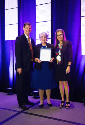
Barb Ryan receives a 2019 William T. Pecora award for outstanding contributions toward understanding the Earth by means of remote sensing.
Throughout the conference one was conscious of being in the presence of mature, successful scientists, conducting and managing international research of considerable importance. LIDAR Magazine has never bubbled with enthusiasm about the panel discussions at conferences – they’re often composed of sincere panelists unable to go beyond what they said in their papers, or understimulated by unimaginative chairpersons. Pecora 21 was different: three panels of real experts gave deeper, inspiring insights under the expert chairpersonship of Stephen Volz (NOAA), Anne Hale Miglarese (Radiant Earth Foundation) and Mark Doherty (ESA). In addition, there was “A conversation on the Landsat program and its data policy”, an informal session with a group of leading experts, moderated by the energetic, ubiquitous Barb Ryan – they totaled 244 years of experience! With several of the authors on the platform or in the audience, LIDAR Magazine took a note to re-read again the Landsat’s Enduring Legacy[1]. To attend any of these sessions was a privilege – one came away marveling at the intellect and accomplishments of the participants.
In the second panel discussion, Kass Green (Kass Green & Associates) described her work studying wildfires in Sonoma County, California. She didn’t have to struggles for veri similitude: she was one of the 800,000 PG&E customers whose electricity supply was cut off to reduce wildfire threat! She analyzed data to relate fires to variables such as ladder fuel and emphasized that three of the five most important were measured using lidar. “Beg, borrow and steal for lidar!” she recommended. Other counties in Calfornia are adopting the same methodology and Kass has undertaken to write up her project for LIDAR Magazine. She repeated her message in front of the NASA Hyperwall in the lunch break and lidar again ruled the roost.
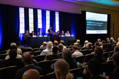
Nick Clinton, Earth Engine Developer Relations, explains Google’s position on earth observation monitoring and data technology. His full presentation is @ bit.ly/ee_pecora
But, overall, lidar was hardly abundant. LIDAR Magazine was disappointed that there was not more about ICESat-2, the fabulously advanced lidar space mission, of which we were invited to the launch in September 2018. The USGS 3DEP program was acknowledged in several presentations and, indeed, USGS itself offered updates and we hope to solicit articles on these for publication in the near future. The focus of a session entitled, “Lidar vegetation canopy metrics: toward developing standards”, was undoubtedly lidar. Meanwhile, in a parallel session, Jörg Herrmann, SVP of start-up Capella Space, gave a riveting account of a forthcoming, private-sector SAR constellation scheduled for completion in 2022 – we have an interview with him in preparation.
Overall, however, this excellent conference was inspirational, educational but a tad light on lidar. As LIDAR Magazine left Baltimore, however, depression returned. We had seen the world’s glittering talent, its best engineers, managers, data experts and scientists, probing and understanding the symptoms of the deterioration of the Earth and its atmosphere. They did so not long after Greta Thunberg and her followers enjoyed a less than effusive welcome in some quarters. Geospatial luminaries are subject matter experts rather than legislators – or do our aspirations rise higher, as did earth observation back in 1972?
[1] Landsat Legacy Project Team, 2017. Landsat’s Enduring Legacy: Pioneering Global Land Observations from Space, American Society for Photogrammetry and Remote Sensing, Bethesda, Maryland, 586 pp.