
At the end of 2017, managing editor Stewart Walker visited Phoenix LiDAR Systems to learn about their core competency in integrating lidar systems with UAVs1. One year later, Walker visited both Phoenix and one of its UAV-lidar clients, Precision Aerial Compliance Solutions, to examine use of this new technology over the vast plains of Texas.
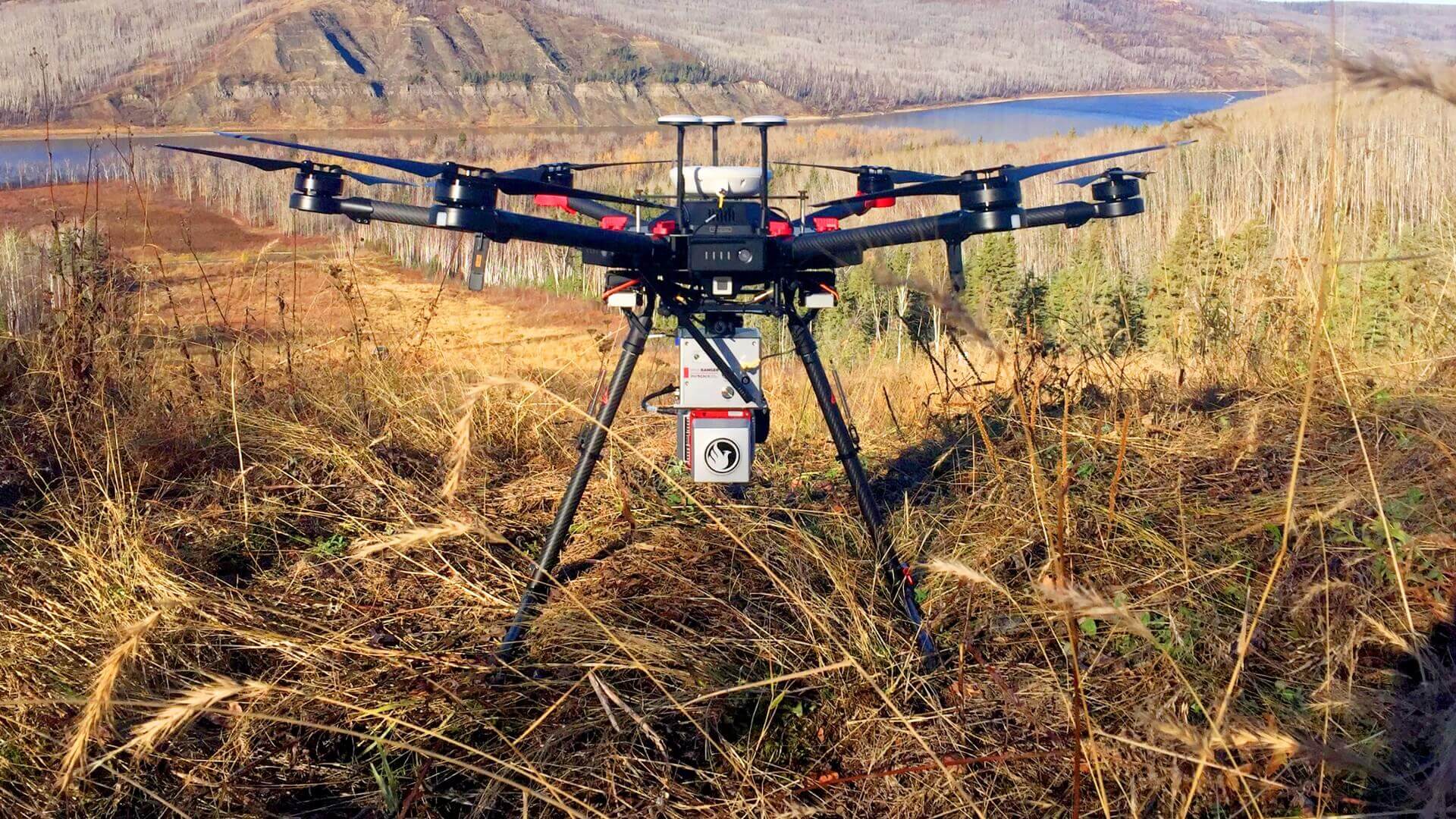
Figure 1: Phoenix LiDAR’s miniRANGER UAV system is designed to acquire survey-grade LiDAR data and high-resolution 42 MP RTK photogrammetry at up to 100 meters AGL. This modular system can also be mounted on vehicles and backpacks for more flexibility.
A PDF of this article as it appeared in the magazine is available HERE
Phoenix LiDAR Systems specializes in building lidar systems for UAV integration, producing hardware and software for surveying and mapping companies to collect the data they need with as little operating overhead as possible. This magazine’s focus on the innovation and application of lidar technology led to our meeting in December 2017, where managing editor Stewart Walker met with Phoenix CEO Grayson Omans and several of his colleagues to discuss opportunities presented by integrating lidar technology with unmanned aerial vehicles. At that time, UAV-photogrammetry was a popular option, but for lidar, the weight and operating complexity continued to present obstacles for UAV integration. Omans’s idea to use UAVs for aerial lidar gave operators the option to take on projects typically considered too small for manned missions, and with the added benefit of lower costs and liabilities. Indeed, Phoenix’s completion of the industry’s first UAV-lidar flight was a major part of last year’s LIDAR Magazine story.
As readers can attest, there are a host of sensing technologies for surveying and mapping, each with its own strengths and weaknesses. Lidar can be used to produce survey-grade data (Figure 1) in situations where other options, such as photogrammetry, may be limited by factors of vegetation, light, and more. In this article, we explore Phoenix’s progress in the past year, and look into the work of a successful aerial inspection company whose reliance on Phoenix solutions has contributed to its rapid expansion nationwide.
While UAV-lidar sensing fills a valuable need, the complexity of its operation can be an obstacle to surveying and mapping professionals. Learning how to fly a drone, operate lidar equipment, and post-process the raw data can itself be a major investment on top of the financial costs of these systems. “UAV-lidar is already changing the industry, but if it’s too difficult or expensive, companies will be hesitant,” said Omans. In response, Phoenix set its sights on building “end-to-end” packages that include hardware, software, and training to make it easier for clients simply to buy and operate.
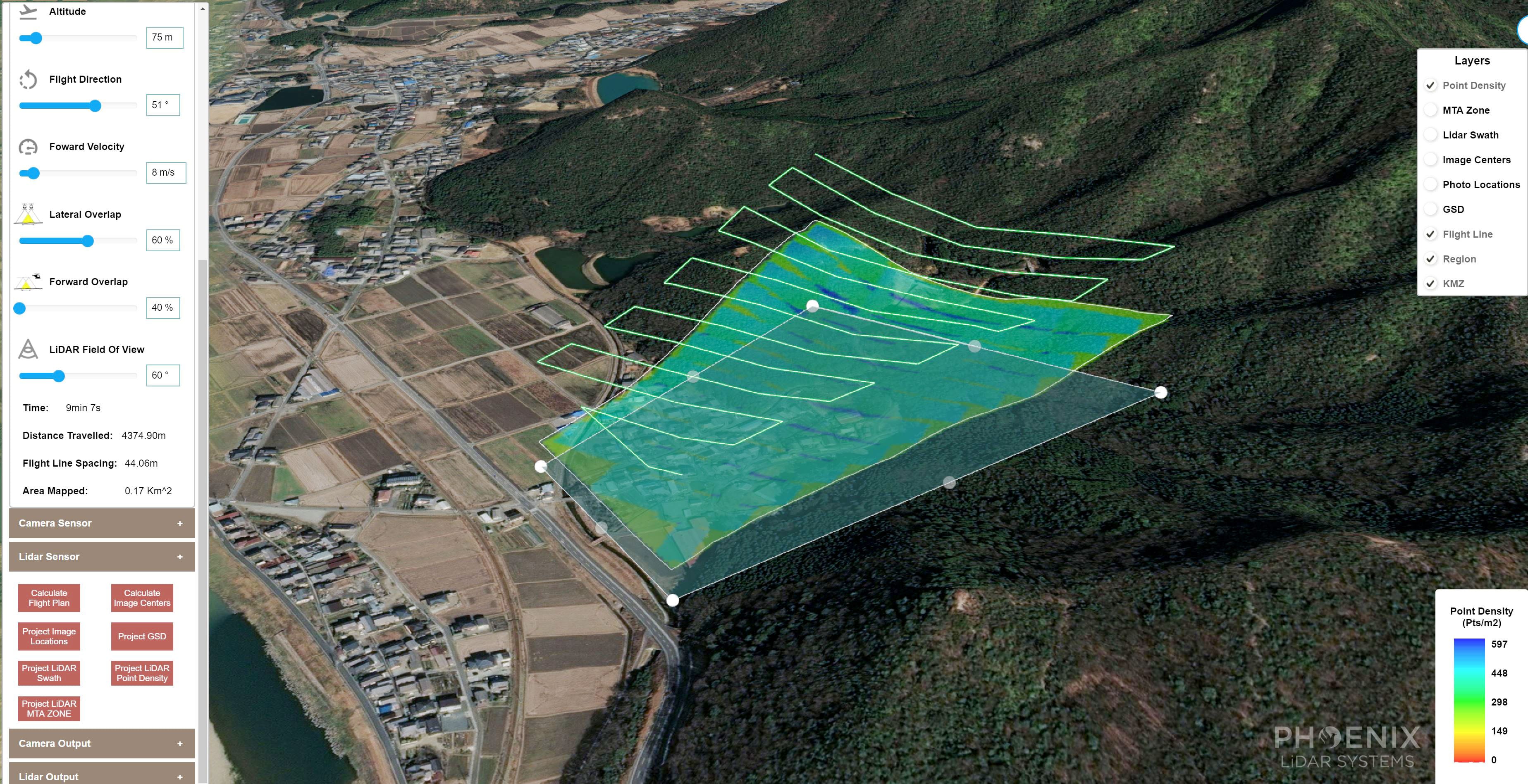
Figure 2: Phoenix Flight Planner enables clients to build flight plans that optimize data collection based on factors such as laser strength, vegetation, terrain, and more. The resulting KMZ can be uploaded for autonomous UAV flight, further simplifying the lidar workflow.
The UAV-lidar workflow
Phoenix’s UAV-lidar workflow can be simplified into three major phases: flight planning, data collection, and post-processing. Last year’s article covered Phoenix’s work to streamline the first two of these phases, resulting in Phoenix Flight Planner and Software Suite respectively.
Through Flight Planner (Figure 2), operators can develop an autonomous flight path to optimize data collection based on laser strength, terrain, swath width, and more. The software produces a KMZ for the UAV’s flight system.
Once the flight is planned, Phoenix Software Suite monitors and controls the lidar hardware during flight, enabling operators to review raw data in real time and make adjustments and corrections while still in the field. The system seamlessly down-samples and transmits collected data to the base station laptop via 4G or local WiFi.
The developing story in the last article was the solution for the third phase: post-processing. While Phoenix LiDARMill was in its nascent stage, its goal was to become the industry’s first cloud-based lidar post-processing system, using a subscription model and automation to bring down costs for the end user. In our recent visit, Omans was pleased to report a successful launch and growing user base, and gave us a taste of some of the upcoming features that Phoenix co-founder and software lead, Dr. Ben Adler, is driving. These details will be part of a forthcoming article on the technical developments that can lead the expansion of UAV-lidar.
The marriage of hardware and software
While a UAV-lidar system requires powerful GNSS and IMU componentry, the heart of the system is its lidar sensor. The automotive industry’s heavy investment in lidar sensor development for autonomous driving has been a beneficial coincidence, as sensors decrease in cost and grow in accuracy. As these manufacturers compete to produce more powerful and accurate sensors, Phoenix tests and integrates successful models into its own systems, offering, in turn, greater mapping accuracy to its own clients.
The relationship between Phoenix’s hardware and software is best understood in the light of the final application of the system: many of Phoenix’s customers are service providers in various industries, such as surveying for power utilities, damage assessment, construction, and more. In these environments, lower-cost technologies such as photogrammetry struggle, though they thrive and may even be preferable in suitable conditions. UAV-lidar must be able to provide survey-grade data despite dense or downed vegetation, poor ambient lighting, and more. Phoenix hardware and software work together to collect and feed data from integrated sensors into the Navigation Box, or “NavBox,” from which it is then downloaded after the mission for post-processing.
The information collected from onboard GNSS, IMU, and lidar hardware is used to produce detailed survey-grade data to be included in final deliverables. This stage, known as post-processing, is so daunting that some UAV-lidar providers don’t offer training or service for this phase at all, instead pointing clients to third-parties that specialize in this area. This reaction is understandable, as post-processing costs quickly balloon: from software licensing that can run in the tens of thousands of dollars, to the investment in computing power that handles the data, to the engineer(s) who must be trained to operate it all, lidar post-processing can be cost-prohibitive for medium-sized surveying and mapping organizations. To lower the barrier to entry, Phoenix launched LiDARMill as the first cloud post-processing platform for lidar.

Figure 3: Phoenix LiDARMill produces a smoothed trajectory, automatic flight-line detection, minimization of offsets from overlapping flight lines, and classification of ground/non-ground surfaces. Phoenix believes that it can drive down UAV-lidar costs through LiDARMill’s automation and subscription-based cloud service.
Adler and his team of engineers have worked for several years to develop algorithms and operations that can take into account GNSS and IMU data, combined with pattern identification within raw lidar data, and a host of other factors to perform LiDARMill’s four main features: a smoothed trajectory, automatic flight-line detection, minimization of offsets from overlapping flight lines, and classification of ground/non-ground (Figure 3). Through automatic flight-line detection, LiDARMill reduces post-processing time by detecting and omitting mapping data collected during extraneous flight maneuvers, such as turns and calibration patterns. LiDARMill’s end result is a LAS file and gridded DTM that can be used for further processing or delivered directly to the client. Among other features to be detailed in an upcoming LIDAR Magazine piece, future LiDARMill releases will include in-depth reporting and analytics based on post-processed data.
In cases requiring more precise classification and post-processing, Phoenix continues to offer training and licensing for the major software bundles that would be required. Clients thus have the option to choose between traditional post-processing training and LiDARMill automation, whichever is more suited to the needs of their own customers.
Precision Aerial at work
Phoenix, which specializes in UAV-lidar integration and data processing, leaves mapping operations to its clients, for example, Precision Aerial Compliance Solutions3, of Conroe, Texas. Their symbiotic relationship has produced a number of “win-win” scenarios: Phoenix’s hardware and software enable Precision to take on more challenging surveying projects, while Precision in turn offers Phoenix feedback and insights that enable the manufacturer to develop a more competitive product ecosystem.
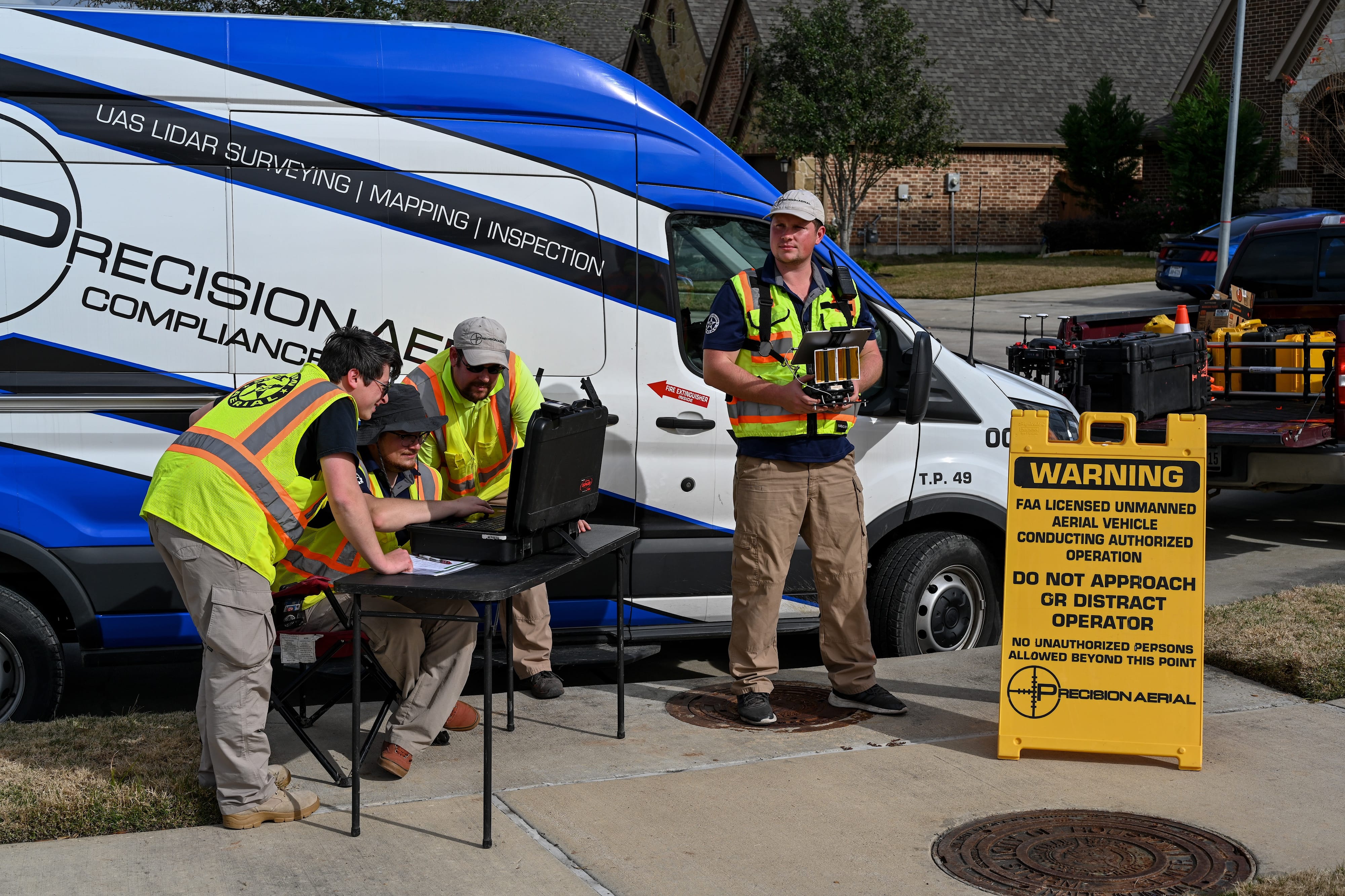
Figure 4: Precision’s “quick response team” prepares to launch its miniRANGER system on a surveying mission. Due to the nature of their surveying missions, the Precision team includes FAA-licensed UAV pilots who oversee all aspects of flight operations.
“Precision is in the data business,” says founder and CEO Scott McGowan, explaining the relationship with Phoenix, “but if I collect data and can’t process it or give useful insight to my client, the UAV and sensors are no good.” As the Precision team (Figure 4) continues to push Phoenix technology to its limits, “we call Phoenix a lot,” he continued. “We’re super happy with these guys. It’s a strong relationship that works.” The feeling is mutual, and, in our interview, Omans added, “Phoenix LiDAR is the tool-maker, and Scott has the insight.”
In establishing Precision, McGowan assembled a team that would focus on surveying and engineering services using UAVs and a variety of sensing tools, including photogrammetry. To expand Precision’s offerings beyond photogrammetry, McGowan began a year-long search for the right lidar provider and determined that, although Phoenix was more expensive, it was more competent than its competitors. In our interview, he particularly noted that Omans has been a pathfinder in bringing lidar to UAVs.
When starting the company, McGowan sought to combine his interest in radio-controlled hobby planes and helicopters with his years in Wall Street energy trading. True to his history, Precision offers inspection services mainly to the oil and gas and engineering/surveying industries. The company has performed projects for numerous county and city entities within Texas, including both general survey and disaster response work to help them develop flood-planning strategies.
Use case: damage assessment
Following Hurricane Harvey in 2017, Precision conducted a disaster response survey for The Woodlands, a Texas community of over 90,000 residents. Local authorities wished to analyze changes in the watershed to determine what actions would be necessary to avoid such catastrophic flooding in the future. They further hoped to preserve the natural beauty of the area by making adjustments to existing streams and creeks in lieu of large concrete drainage canals, a solution adopted in other cities prone to flash flooding, such as Los Angeles and Las Vegas.
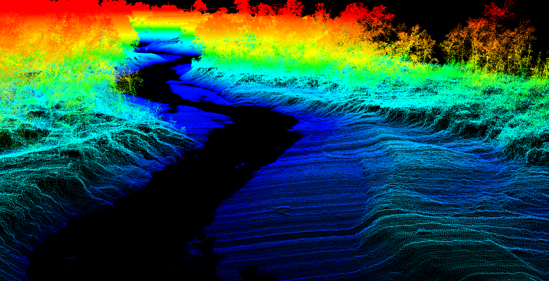
Figure 5: Precision used its Phoenix miniRANGER UAV lidar system to perform an emergency damage assessment following Hurricane Harvey in 2017, delivering survey-grade data in five days despite dense and downed vegetation.
Dense vegetation and damaged infrastructure presented significant obstacles to the Texas survey, both for conventional land surveying and UAV-photogrammetry. These exact challenges, however, offered a strong case for Precision’s UAV-lidar system, a Phoenix miniRANGER (Figures 1 and 5). To perform the damage assessment, Precision mobilized its quick-response team (Figure 4) to map the area. Their ability to provide a fast, survey-grade assessment produced data critical to city planning for future disasters. By comparison, McGowan explained that dispatching a two-person survey crew to work this project would have required 30-40 days to cover the forested area. Precision not only collected the data, but post-processed and delivered it to the client in five days.
Use case: volumetrics
In another mission, Precision was asked to help with a complex volumetrics challenge to calculate the amount of silt removed during a major dredging project. In one of Texas’s busiest ports on the Gulf of Mexico, Precision was tasked with measuring large silt deposits moved by contractors on to a local island, which had over time become densely overgrown. Not only is the site surrounded by a port area busy with channel traffic, but land survey teams had been unable to complete their measurements because of constant dangers of sinking in the quicksand-like spoils.
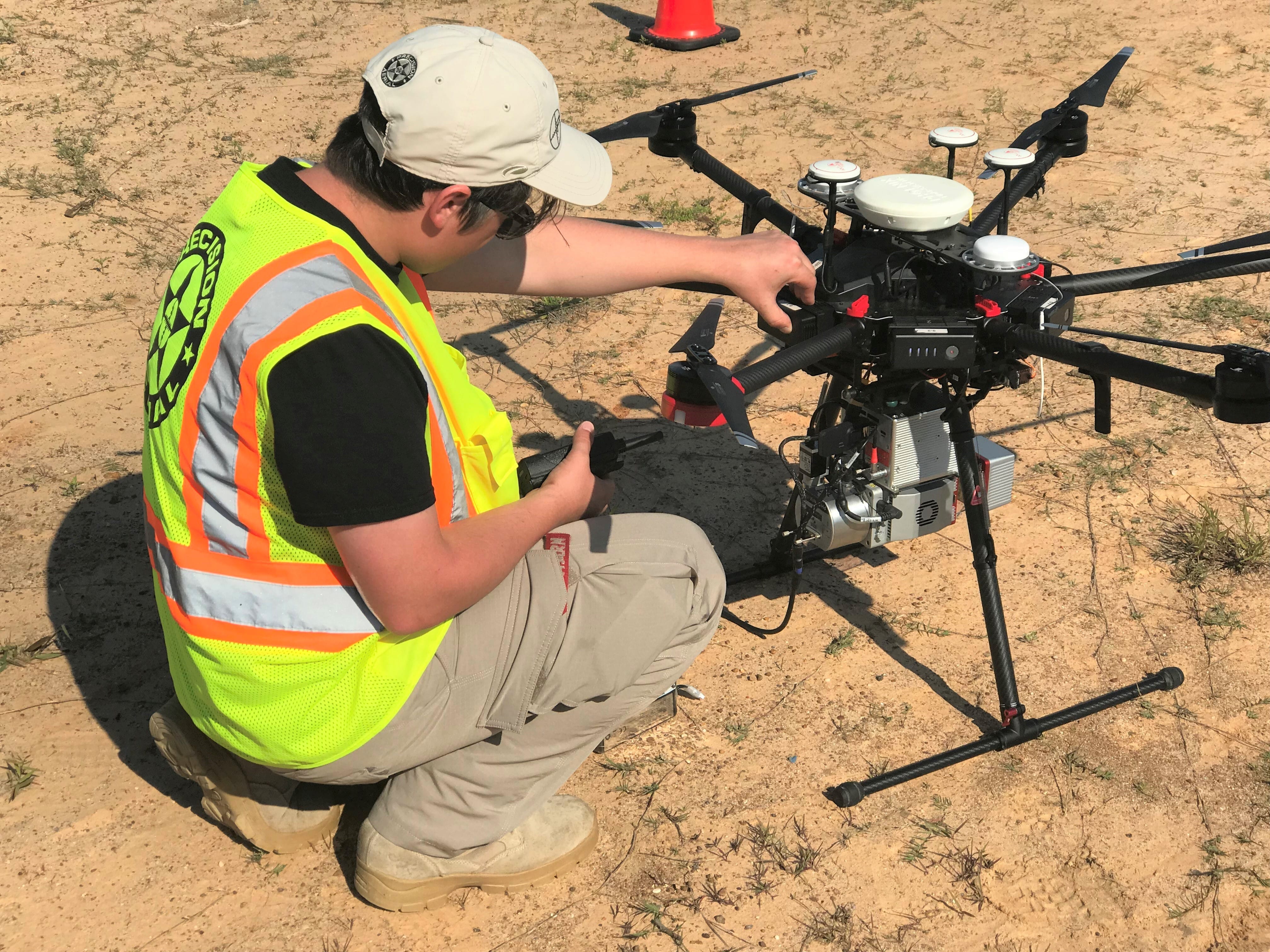
Figure 6: A Precision team member prepares their miniRANGER for the mission. Most lidar systems by Phoenix are modular and can be unclipped from their UAVs and mounted onto vehicles, backpacks, and more.
Precision knew from its experience that its UAV-photogrammetry equipment would have produced accurate results, but only in areas where no vegetation had grown over the deposits. Precision instead opted to use its Phoenix miniRANGER system (Figure 6). A team placed ground control points around the perimeter and in solid areas where they could safely venture, then launched the miniRANGER. The system was able to penetrate vegetation and perform survey-grade measurements to calculate the location and volume of spoils deposited. Despite the challenges faced by photogrammetry and manned teams, along with obstacles from natural and man-made causes, Precision was able to produce an accurate lidar volumetric assessment. “We solved the unsolvable on that one,” said McGowan.
Where is Precision now?
With its rapid growth throughout Texas, Precision eventually caught the eye of LJA Engineering, a Houston-based engineering company that boasts more than 650 engineers, 80 of whom are professional land surveyors (PLS). In July 2017, Precision agreed to be acquired by LJA, increasing its reach and growth potential far beyond Texas.
Since that time, Precision has expanded into North Carolina, South Carolina, Louisiana, Georgia, and Florida, but McGowan has his sights set on the rest of the United States. Joking that, “being the shiniest tool in the shed is not enough,” McGowan pointed out that his team had also made its contributions felt in the wider LJA community, completing 73 successful UAV-lidar projects in 2018, a statistic that he aims to double in 2019.
Endnote
When Omans had the idea in 2012 to combine his love of UAVs and technology, little did he and Adler know that they would disrupt the industry by developing the first commercial UAV-lidar system. Their work was an important step forward in aerial surveying not only because of its novelty, but because it filled such a significant gap. UAV integrations existed for other technologies such as photogrammetry, but lidar sensing was still confined to manned aircraft, MMS and TLS. Their continued development through the years has enabled a host of other industry “firsts,” and helped to establish a global client base.

Figure 7: The Phoenix TerraHawk CW-20 is a powerful fixed-wing UAV-lidar platform, enabling operators to combine the altitude, stability, and speed of a fixed-wing aircraft with the safety and convenience of a vertical take-off and landing (VTOL) system.
With the support of industry partners such as Precision, Phoenix continues to build custom UAV-lidar integrations for clients of all sizes, including national and local governments, research institutions, and commercial mapping companies. With its focus on flexible and modular systems, Phoenix’s lidar systems can be integrated with a variety of UAVs, from the traditional multi-rotor to fixed-wing drones, for example the Phoenix TerraHawk CW-20 (Figure 7).
As LIDAR Magazine continues to monitor the growth and development of lidar in various industries, we look forward to taking a deep dive into the software development that will drive LiDARMill into its next phases, with more refined automatic classification and data analytics. We’ll also investigate the contribution of Dr. Ben Adler, whose engineering team at Phoenix are the faces behind the developments that serve to make lidar more attainable for a larger number of organizations.
1 Walker, A.S., 2018. Phoenix LiDAR Systems: excellence in UAV integration, LIDAR Magazine, 8(1): 22-29, January/February.
2 Further detail is available at www.PhoenixLiDAR.com.
3 Further detail is available at www.PrecisionAerial.co.