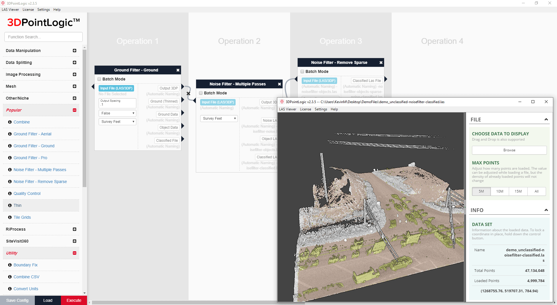
Figure 1: Easy and effective noise filtering and classification with 3DPointLogic.
Almost a decade ago, a small, forward-thinking surveying and engineering firm based in Calgary, Alberta began collecting large amounts of laser scanning data and quickly realized that there was a lack of suitable tools in the market to assist with the efficient processing of this voluminous point-cloud data, or, even more importantly, allow them to easily visualize and share that data with their clients.
Frustrated by their attempts to accomplish the types of results they desired with existing software offerings, they decided that they would attempt to solve their issues themselves. They began writing code for a set of algorithms to perform various functions that would clean the point-cloud data and transform it into an optimized format for use in creating end products for their customers. They produced a suite of functions akin to a processing “toolkit”, which they introduced to a set of other industry practitioners. This peer review enabled them to realize that they might also be able to help resolve those same issues for others. Encouraged by the feedback from their counterparts, they decided to hire a team of professional software developers to make the products market-ready. Hence Solv3D Inc. was born. Founders Dr. Robert Radovanovic and Chris Tucker were no strangers to starting up businesses: they came from two companies, Sarpi Engineering and Point Geomatics, which merged and became SarPoint Engineering. Solv3D was incubated as part of SarPoint, which continued to operate independently in the survey and engineering services space, until another merger, with McElhanney Geomatics, occurred in September 2017 and Solv3D was spun out to operate wholly as a standalone entity.
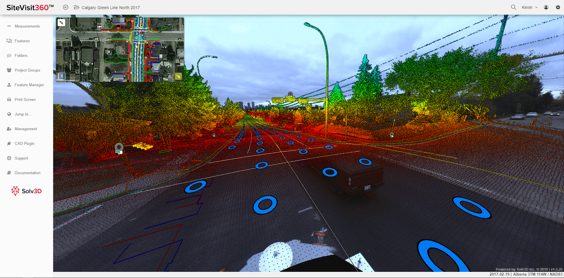
Figure 2: Within a single view, overlay DXF, SHP and KML/KMZ drawings directly on top of imagery and point cloud data in SiteVisit360.
2015-2017 was a period of product development at Solv3D, using customer pilots and evaluations to collect feedback that would allow them to flesh out the foundational requirements and prepare for the commercialization of the products. During this time also, the web-based visualization and collaboration platform was conceived and developed. It allowed users to view any type of point-cloud data with panoramic or planar images, simply, in an internet browser. Not only could those collecting the data show it to their clients, but clients taking delivery of the data were provided with a quick and easy way to quality check it and be able to share it with others in their organization. No special software expertise was required.
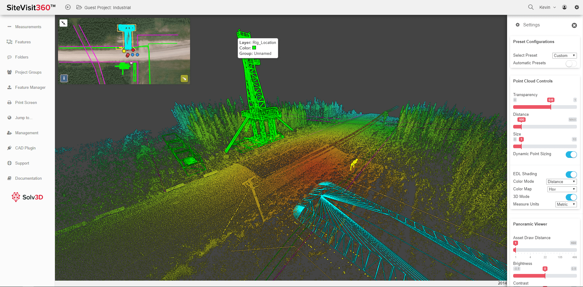
Figure 3: Choose to work completely in 3D mode while still being able to utilize model data within the same single scene view.
Now Solv3D had a full offering—two products that could be used as standalone applications or in tandem to create a simple, intuitive and powerful overall solution. Market introduction began in February 2018 and the products quickly evolved with many new features and functions in direct response to end-user feedback. Tools that are easy to use, don’t require super computers and are data-agnostic are key features of the Solv3D product palette. The inherent value of geospatial data is not fully derived until it can be accessed and shared throughout an organization, or by external parties, for multiple purposes. The Solv3D products enable organizations to realize a far greater return on their data investment, by providing tools that not only provide an easy and cost-effective way to optimize point-cloud data, but also extend data sharing and use to all stakeholders.
3DPointLogic™ is a middleware toolkit that enables users quickly and easily to clean and prepare their point-cloud data (Figure 1). The application is hardware-agnostic, meaning that the sensor used is irrelevant. Indeed, point clouds from varied sources and hardware brands can be combined into a single point cloud. This allows users to gain efficiencies in processing all the data from a project as a single file versus having to run each dataset through a proprietary application and trying to combine them post hoc.
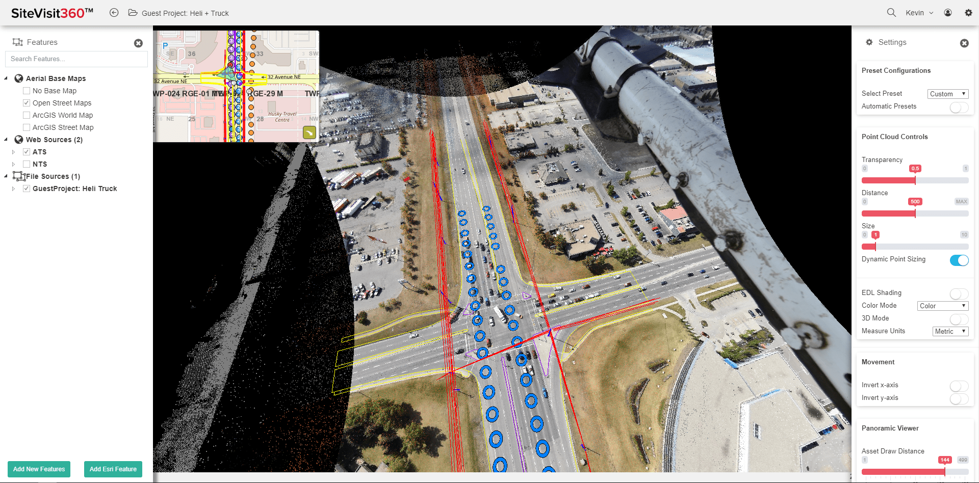
Figure 4: The combinations and uses of various geospatial datasets are limited only by the imagination of the end user.
SiteVisit360™ Geospatial Collaboration Platform is a browser-based application in which a myriad of datasets can be merged together to provide wholistic views and garner situational awareness of projects, assets and areas of interest (AOIs)—regardless of a user’s geographic location or level of software expertise (Figure 2). Collaboration is fostered within the application through several interactive tools, controlled and customizable by the account administrator (Figures 3 and 4). Users are able to easily work together on projects or in managing their assets. Measurements can be taken, annotations made and geolocated tags attached to assets and AOIs to connect to existing information. Users can also record and communicate new information, creating a living system of record. Only an internet browser is required, so the engagement of all stakeholders is far more easily achieved. For example, a large construction and engineering firm currently uses the application to hold their weekly project status meetings. They meet virtually, but are able to visualize, mark-up and record comments on the coming week’s action items within the system. The project foreman is then able to access these directives and annotations, while on site.
The announcement of the Esri and AutoDesk partnership in 2017 started a trend towards bringing together GIS and CAD, spatially based disciplines that previously had been rather disparate. SiteVisit360 is the visualization tool that provides a bridge for users from both sides to be able to work together in a truly collaborative manner. AutoCAD users can load their DXF models and GIS users can import shapefiles, ArcGIS Online Maps, or other web services—all within the same scene and all accessible using only an internet browser.
The target audiences and applications for these products are very diverse; from estimation and planning, for example, to quality control, quality assurance, safety analysis and risk assessment. Solv3D assists clients in using technology to provide them a way of doing their job more safely, effectively and efficiently. Although the applications will continue to evolve, SiteVisit360 and 3DPointLogic are already making the utilization of point clouds and other geospatial datasets much easier: from anywhere, by anyone, at any time.
Tammy Peterson is Vice President of Marketing and Sales at Solv3D Inc. Her professional experience spans more than 20 years in the areas of sales, marketing and channel strategy and development. She has worked in a broad range of industries but entered the geospatial realm in 2007 and worked for over a decade at Valtus Imagery Services (a division of North West Geomatics), managing and building the data-as-a-service business and its sales channel, which would ultimately become the Hexagon Content Program, after North West was acquired by Hexagon in 2014. In December 2017, she joined Solv3D Inc., a Calgary software start-up focused on innovative geospatial software applications.