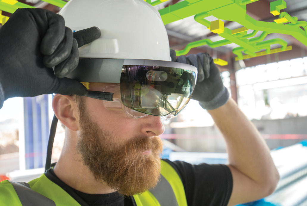
Mixed reality is a form of augmented reality (AR) that merges real and virtual worlds to create brand new environments where physical and digital components interact in real time. With Trimble Connect for HoloLens, users can interact with what they see on a 1:1 scale and compare components against design and installation guidance.
There’s no question digital transformation is making geospatial technology increasingly relevant in industries globally, whether adding precision to a position, context to mass data collection, or content and attributes to a project model.
Editor’s note: A PDF of this article as it appeared in the magazine is available HERE.
Spurred by an evolution in computing power and connectivity that soon will improve exponentially with 5G connection speeds, the rise in global demand for geospatial data and geo-enabled devices is propelling technologies to evolve. In fact, according to a recent GeoBuiz report, the global geospatial market is expected to grow an estimated 13.6 percent through 2020, significantly faster than the growth rate of 11.5 percent from 2013-2017. It also shows the GNSS and positioning industry—the largest of the geospatial universe—is estimated to grow at a CAGR of 13.5 percent to reach $260.8 billion in 2018-2020. The GIS and spatial analytics market is the second largest, the report states, with rapid growth expected to continue from $66.2 billion (a 2017 estimate) to $88.3 billion in 2020.
Scanning the horizon, these questions emerge: What technologies will transform the geospatial industry in the next few years? What are the next big steps required to make spatial content more relevant?
Geospatial professionals are hungry for advances in technology that can help them do more, including providing richer, more insightful deliverables to general contractors, civil engineering and construction teams, designers, business owners and key project stakeholders.
When considering the next wave of geospatial technology, the most disruptive themes include sensor fusion, autonomous vehicles, mixed reality, big data analytics, the as-a-service business model and 3D modeling/BIM. Many of these innovations will be available not merely through a single tool, but through the integration of multiple technologies.
Here are the key technology trends we believe will drive the geospatial industry forward over the next 18-24 months:
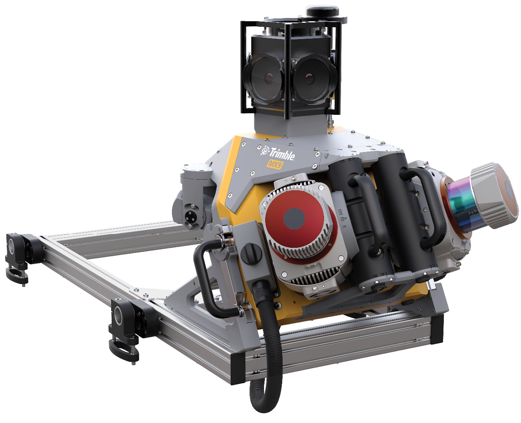
With the Trimble MX9 Mobile Mapping System, all sensors are time synchronized with precise GPS time tags and are linked to the trajectory that is recorded with the GNSS/IMU subsystem. That way, all recorded points and images can be properly aligned in a post-processing step.
Sensor Fusion
Sensor fusion is one of the leading edges of product development because of the power that comes from combining multiple different sensor types or technologies in ways that maximize their combined strengths while minimizing their combined weaknesses.
The fusion of sensor technologies to include more IMUs, GNSS and emerging technologies like Solid State LiDAR and SLAM processing is making it possible to merge multiple disciplines of mass geospatial data capture into one seamless routine.
Mobile mapping systems are one example. They combine the various strengths and weaknesses of different types of sensors—inertial (IMU), wheel speed, GNSS, cameras and LiDAR—and fuse these sensor outputs, achieving greater levels of accuracy and detail for engineering operations and design.
Having different types of sensor data can be extremely powerful, but even more beneficial is fusing that data for analysis and decision making. Supported by the right software, sensor fusion is about getting the most out of various sensors and sensor combinations to solve business problems.
This technology integration will remain a growing trend in the surveyor community as more geospatial professionals take advantage of unique sensor combinations purpose-built to help provide better geospatial context.
Data-Driven Decisions
There’s been significant effort and accomplishment in making mass data collection easier over the last decade. Looking ahead, geospatial professionals will need to spend an equal amount of effort to make that data useful in meaningful ways. In other words, technology innovators need to provide geospatial professionals with the processing tools and software applications necessary to effectively process the data into deliverables that matter.
Also, because the future geospatial industry has limited tolerance for restraints such as the use of multiple software packages to store and analyze data, we will start to see further adoption of a single geospatial data hub that enables users to bring all disparate data to a single department, enabling field-to-finish with confidence. This central hub will also allow geospatial professionals to choose the best hardware tool for the job, whether they walk it, fly it or drive it to gather data.
The ultimate goal will be to move away from heterogeneous files—and those collections of data—into reusable, more reliable systems of record that can be used across multiple disciplines and multiple user personas. The cloud-based platforms and feature services will play a major role in eliminating unnecessary physical data transfer and connect and enable easier project collaboration and information exchange.
As a Service Business Model
Geospatial customers increasingly see solutions offered as a subscription or pay-as-you go service, rather than a one time purchase. This model is providing benefits to enterprise and large organizations enabling them with a more predictive cash flow. The as-a-service model provides easier access to professional grade measurement technologies, enabling more people to enhance and streamline workflows and project deliverable creation. The as-a-service approach results in more people using their smartphones and mobile devices to receive satellite data for a precise position. This technology advancement will multiply the capability of field organizations to increase the reach and rapidness of data collection in the coming years.
Modeling and Visualization
Geospatial data—such as point clouds, complex meshes and terrain models—are often difficult to explain and deliver to clients. The use of augmented reality (AR) and mixed reality (MR) tools will increase in the next several years to improve understanding of existing site conditions by overlaying models over the existing environment. For example, a user of augmented reality technology could view existing underground services and future landscapes overlaid on a worksite to avoid hitting a utility line during excavation work. Other benefits include collaboration, planning and asset management. Organizations that can offer this functionality to their customers will have an edge on the competition.
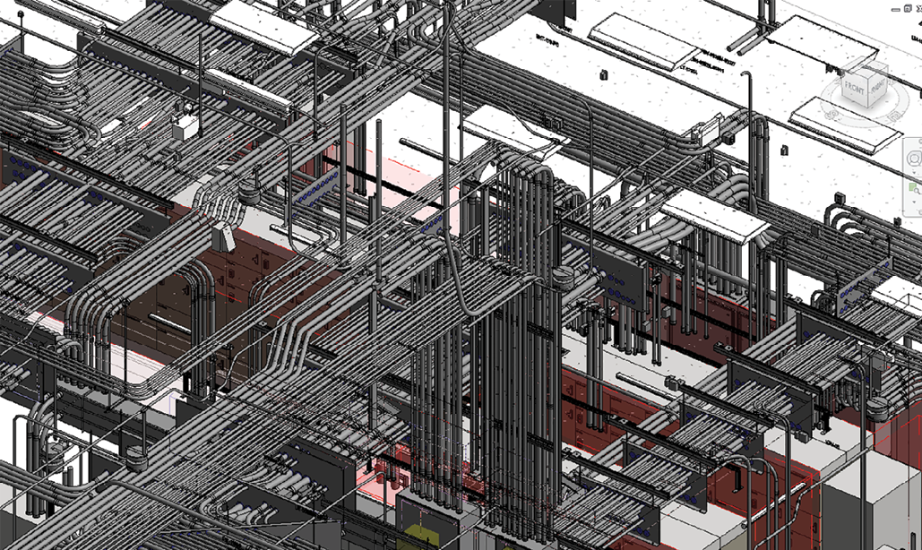
BIM technology creates intelligent models that promote a richer understanding.
3D Modeling, BIM
The design and construction industry is at a tipping point in which BIM (Building Information Modeling) can positively impact geospatial professionals’ work the more they embrace it. However, prospective BIM adopters need to realize the technology not only provides intelligent 3D modeling, but it also offers a centralized platform for sharing data to help partners communicate effectively – in real-time. When surveyors take advantage of BIM holistically, they are not only factoring in the traditional aspects of a building’s design but also generating rich data spanning the range of properties of a structure’s components, construction and maintenance.
The challenge with BIM adoption is not just to encourage surveyors to use newer technologies, but rather to convince them to start seeing it as a paradigm shift in the design and build process altogether. At its core, BIM is meant to transform how project teams work together on a job, from start to finish.
Future Technology Integration: Closing the Gap on Segmented Functionalities
As the digital world continues to evolve, the relevance of geospatial information and technology will continue to build on its current momentum, adding spatial dimensions to many business processes.
Traditional silos that previously segmented functionalities will increasingly dissolve, with further integration driven by cutting-edge technologies. This integration will help reduce the gap between data capture, processing, analysis and delivery of an easy-to-understand, cohesive image of the real world, from surveyor to customer.
Looking ahead, as more geospatial professionals embrace the power of these digital advances, there will be productivity improvements, cost savings and new business opportunities to realize for years to come. 
Boris Skopljak is marketing director for Trimble Geospatial strategy and analytics.
Chris Trevillian currently works as market manager within Trimble Geospatial for optical, imaging and 3D scanning solutions.