
A Singapore skyline in spherical view with point-cloud overlay
As part of Singapore’s quest to be a smart nation, the Singapore Land Authority embarked on a 3D national mapping initiative in 2014, involving mapping the island nation via airborne laser scanning, along with airborne imaging, and mobile laser scanning and imaging. Orbit GT technology was used to manage the contents of the downstream mobile laser scanned and imaged data. The ease of use and the interaction of these high-quality datasets with Orbit GT tools have opened up many possibilities for stakeholders within the governmental agencies to manage features and assets of interest efficiently.
Editor’s note: A PDF of this article as it appeared in the magazine is available HERE.
Introduction
The Singapore Land Authority (SLA) is a statutory board, formed in June 2001 to manage Singapore’s land resources. Its vision is, “Managing the country’s limited land to create unlimited space”. SLA is thus dedicated to optimizing land resources for the economic and social development of Singapore. As Singapore is a small island nation, land needs to be managed in the most efficient way. This can be achieved by creating space above and below ground.
When these spaces are created, 2D maps are no longer adequate to fully represent the real-world GIS information in Singapore. The airspace and subterranean spaces all overlap with the ground level information, making it hard to visualize and represent them on a map.
In 2014, SLA embarked on a journey to create a Singapore Advanced Map by mapping the whole of Singapore with 3D geospatial data through the 3D National Mapping project. This is part of the Smart Nation initiative led by the nation’s Smart Nation and Digital Government Office. Its aim is, “Improving the lives of citizens, creating more opportunities and building stronger communities by harnessing technology and gathering insights from data to the fullest.”

Orbit GT 3DM Content Manager
3D National Mapping
The demand for 3D map data is increasing, as 3D data can assist in land development planning, management of underground utilities and infrastructure, flood management, urban airflow analysis, studies of solar potential, and many other applications.
Factors to consider when defining the methodology to collect 3D data include accuracy, level of detail, reliability, area coverage, data format and appearance. In the traditional approach to collecting GIS data, it is possible simply to perform a 3D topology around Singapore, but the level of detail and appearance will not be adequate for the creation of 3D models: the physical appearance will not match the real-world appearance. Through the use and exploration of advanced mapping technologies, it has become clear that 3D laser scanning with imagery is the best available solution to address the considerations for collecting 3D data.
The 3D National Mapping initiative aims to create and maintain an accurate 3D map that is developed once and used by many. The main objectives are to have: high-resolution data in order to meet the requirements of most government agencies; an open standard data exchange format for interoperability and data sharing; a common, authoritative 3D base map to support collaboration among agencies; and a workflow for continuous maintenance to ensure currency of data.
The 3D National Mapping project is carried out in two phases. Phase one is to capture and create an orthophoto map of Singapore and to capture the digital surface and digital terrain data of Singapore. To achieve the goal for phase one, airborne laser scanning and imagery equipment was used. Two twin-engine aircraft were mobilized, each with a sensor system. The aircraft were pre-programmed with flight path data and flew missions to capture both vertical and oblique images. They simultaneously performed 3D laser scanning. The whole data collection exercise was completed in 40 days. Collected 3D data was then processed and put to use to create the Digital Surface Model (DSM) and Digital Terrain Model (DTM). The images were also used to create an orthophoto of the whole of Singapore. The vertical and oblique images paired with the point-cloud data were used to create 3D building models. This data also serves as a base to create the overall framework of the Singapore Advanced Map.
The second phase of the 3D National Mapping project involved a comprehensive mobile collection of road and street data as furniture to supplement the data collected in the first phase of the project. This was carried out by a mobile mapping laser scanner with a panoramic camera mounted on a vehicle. Ground-based laser scanning and a 360° panoramic imagery dataset were collected on approximately 6000 km of roads in Singapore. This exercise captured all road and street features. This mobile mapping 3D data enriches the airborne 3D data with fine detail, at the same time verifying the accuracy of all the building models.
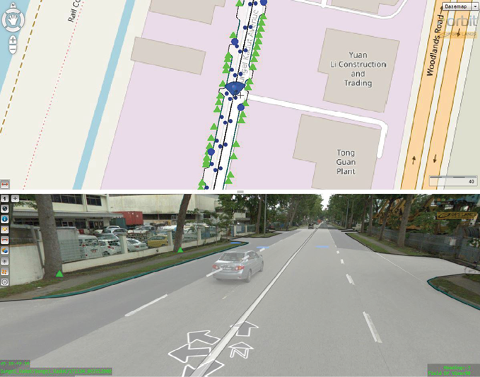
Overlay extracted objects on spherical view and reference map
Orbit GT Smart City solutions
When the data sets are collected and processed, the question arises how to combine them to verify and view them together. The data sets are huge and the available point-cloud processing software could not handle them. They become useable only when they are pieced together and features can be extracted from the data.
GPS Lands (Singapore), an Orbit GT partner, approached SLA with a solution that allows SLA to piece all verify the data that was collected and processed.
Orbit GT’s 3DM Content Manager was used to verify the data that was collected and processed. This software allows the processed point-cloud data and panoramic images to be imported as runs. All the imported runs can be loaded together for viewing as a whole. This is where the data sets can be verified at a large overall scale to check for any mismatched data. The point-cloud data also shows the accuracy of the orthophoto map created from the airborne imagery when overlaid as the base map in 3DM Content Manager.
The features available within the 3DM Content Manager enable SLA to manage the data sets by grouping the data and loading them separately when required. For example, the mobile mapping data of northern Singapore is made up of several point-cloud data sets. In 3DM Content Manager, these data sets can be imported as runs and added into a project to be grouped together. In this way, data can be managed easily, and according to the user’s requirements.
A critical component of the 3D National Mapping initiative is data sharing with stakeholders. The main stakeholders come from across governmental agencies, research institutes and other parties of interest. The next step is to be able to extract the 3D features from the GIS data. Orbit GT’s 3DM Feature Extraction is the tool to be used by SLA to perform feature extraction from their 3D data. In land management and administration, the exact details on the ground provide crucial information for the government to plan and make decisions. Being able to view rich data captured in 3D without having to be physically on the ground is an efficient allocation of resources.
In a particular example of collaboration with government agencies, tree features across Singapore are being extracted as points, with the attributes of coordinates and height. This information allows relevant agencies to manage the greenery of Singapore, to provide high-resolution information for carbon accounting and also to identify the location and estimate the number of trees on State Land.
There are also other use cases where features such as lampposts, curb lines and manholes are extracted to perform verification of the existing GIS data of other agencies, as part of their asset inventory management. Exact coordinates of the data and accurate measurement can be done without having to go into the field for GIS data collection.
Identifying the features on the ground, then extracting and exporting them allows them to be seen on a map at a single glance. This information can be exported and shared with different government agencies, using GIS data to provide them with visualization of their assets. The extracted features can also be overlaid in 2D form, since the data can be exported in various available formats that can be used immediately with 2D GIS data.
Moving forward
In Singapore’s quest to become a smart nation, SLA continues to explore advanced GIS technologies to build and enhance the Singapore Advanced Map. As a plan to move forward on sharing data with various government agencies, SLA is deploying the Orbit GT 3D Mapping Cloud solution for publishing the 3D data. This enables agencies to benefit from the 3D GIS data for their own use cases.
Johnson Ang is project manager at GPS Lands (Singapore). Originally from the IT industry, Mr. Johnson has 10 years of experience in the land survey industry. His subsequent experience with GPS Lands has allowed him to integrate experience from the land survey industry with IT knowledge, and implement advanced GIS solutions. His team specializes in setup and customization of GPS infrastructure systems and Orbit GT solutions.