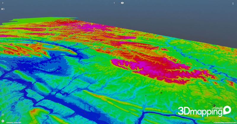
3D Mapping Cloud showing 3DEP aerial LiDAR data of Pennsylvania, colored by height.
Denver, CO, January 25th, 2019 – Orbit GT brings 3DEP content online to show on MAPPS, ILMF and ASPRS conferences Denver, CO.
“Happy to announce that we’ve brought 3DEP LiDAR content of the whole state of Pennsylvania online on our SaaS platform 3dmapping.cloud”, says Peter Bonne, CEO of Orbit GT. “ILMF is all about LiDAR, and this year 3DEP has a prominent position in it. We’re pleased that we can show this great data live and streaming. Come have a look at booth 600 !”
To bring 3DEP PA online, we downloaded all tiles (about 14 k tiles, some 100 Billion points) from the 3DEP website, processed it into 2 Orbit Point Cloud files (PA North and PA South), resulting in files 570 GB and 730 GB large. Quite OK for 3D Mapping Cloud.
All of PA state is available for free online viewing via this link : https://3dmapping.cloud/publication/R1hrPK6bYtPbn1o12Hyf
Note: this link goes online with the full dataset only from Monday Jan 28th, 9am MST !
Come visit us in booth 600 !
As we experience many of Orbit GT customers are using several techniques of reality capture, such as Mobile Mapping, Terrestrial scanning, Aerial Oblique and UAS Mapping, we worked towards an integration of our portfolio to offer a single product line covering the needs for each of these domains. This native integration is a sure win for every customer and user.
About Orbit GeoSpatial Technologies
Orbit Geospatial Technologies is world leader in solutions for exploiting 3D Mapping content in managing, viewing, extracting, publishing, sharing and embedding in workflows, either desktop or cloud based. Orbit GT specializes in 3D Mapping solutions for Mobile Mapping, UAS Mapping, Indoor Mapping and Aerial Oblique Mapping, replacing the big data dilemma with ease of use. Orbit GT is headquartered in Lokeren, Belgium, and enjoys a global business network.
