 International LiDAR Mapping Forum (ILMF) and Lidar Magazine are excited to announce the second annual Lidar Leader Awards, which will be presented at ILMF, taking place January 28-30, 2019 in Denver. This is an exciting opportunity for the geospatial community to recognize the amazing work being done every day by professionals like you.
The joint effort between ILMF and Lidar Magazine will honor some of the people working with lidar technology who have made a significant impact on the industry. We invite you to nominate an individual, organization, project, innovation or university accomplishment. It is an excellent opportunity to showcase innovative strategies and gain recognition among industry peers for some outstanding work. You may submit nominations to any of from five distinct categories:
Outstanding Personal Achievement in Lidar
Outstanding Team Achievement in Lidar (2-99 members)
Outstanding Enterprise Achievement in Lidar (Groups of 100+)
Outstanding Innovation in Lidar
Outstanding University Achievement in Lidar
 If you know of a group, person, project, innovation, or university that should be considered for a Lidar Leader Award, take a moment to review our submission criteria and nominate them at: www.lidarmap.org/lidar-leader-awards
The winners will be recognized and presented with their award during an awards ceremony at ILMF 2019.
Nominations must be received by October 15th, 2018 in order to be considered. Please don’t hesitate to contact us if you have any questions or recommendations.
Make your nominations for the 2019 Lidar Leader Awards
Maptek and LlamaZOO Bring the Mine to Brilliant Life
August 22, 2018 – A collaborative partnership with LlamaZOO will deliver advanced data visualisation in 3D and VR to mining customers.
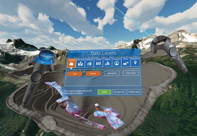
MineLifeVR LlamaZOO Data Layers
Mining technology developer Maptek and augmented reality experts LlamaZOO are teaming together to bring digital twinning and advanced 3D data visualisation to the mining industry.
‘At Maptek we’re all about building on our legacy of innovative approaches to how customers interact with their technical and operational mine models,’ said Maptek Core Technologies Product Manager Chris Green.
‘The collaboration with LlamaZOO exemplifies our support of initiatives that really make a difference to industry.’
LlamaZOO Interactive is an award-winning software studio developing 3D interactive data visualisation solutions for enterprise and industry 4.0. LlamaZOO specialises in centralising disparate spatial datasets and making the information actionable for all stakeholders through real-time engaging 3D and VR/AR.
Maptek stakeholders within customer networks will be able to interact with their spatial data in high resolution 3D, in a format typically only seen with high-end video games, but with actionable real-world data.
‘Imagine viewing live data, such as trucks and shovels, loaded train cars and material stockpiles, in real-time. Displaying real-time grade control data over scheduling activities provides critical information in context,’ added Green.
‘Live and interactive simulation of scenarios via a digital twin of the real mining environment can provide surprising insights. Virtually a risk-free mode for decision-making.’
LlamaZOO leverages developing and creating compelling, interactive 3D experiences from the gaming industry to solve real-world problems for innovative companies. LlamaZOO MineLife VR fuses complex geospatial and mine planning data with IoT data into an interactive, life-sized virtual replica of the planned, current, and future states of a mine site.
‘Users can explore an entire operation from source to port or facility, see hypothetical scenarios and real-time data, create a variety of presentation media such as 360-degree images, flight paths and export these to other more traditional media access points such as web,’ said LlamaZOO CEO, Charles Lavigne.
‘Integrating this capability with the artificial intelligence and machine learning development Maptek is already undertaking, synthesises digital data into a powerful, enterprise level solution,’ Green concluded.
Maptek™ is a global provider of innovative software, hardware and services. Founded almost 40 years ago to service the mining industry, Maptek offers a unique combination of domain knowledge, technical expertise and engineering resources. We incorporate automated workflows and optimised algorithms to collect, analyse and circulate critical information within the operational cycle, closing the loop between planning, production and results. We develop reliable solutions that allow customers to improve safety, productivity and profitability.
LlamaZOO is an award-winning developer of 3D interactive data visualisation solutions for enterprise and industry 4.0. Co-founders Charles Lavigne and Kevin Oke started LlamaZOO in 2014, bringing extensive experience in the videogame industry with companies such as Microsoft, EA, and Ubisoft. The company’s mission is to make big spatial data actionable and understandable for enterprise stakeholders.
Phase One Industrial Launches 150MP Metric Camera and New Aerial Systems
iXM Platform with Advanced Imaging Sensors Delivers Superior Aerial Mapping
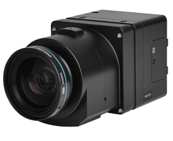 Copenhagen, August 28, 2018—Phase One Industrial, a leading provider of aerial imaging solutions, today launched the iXM-RS metric camera series and new Aerial Systems. The flagship iXM-RS150F camera is full frame, 150 megapixels and available in RGB and Achromatic models. Its ultra-high resolution (14204 x10652) backside illuminated CMOS sensor, fast capture speed (2 fps) and enhanced light sensitivity enable increased productivity in a wide range of aerial image acquisition projects. The iXM-RS camera is the imaging heart of Phase One Industrial’s Aerial System—a fully integrated solution for mapping and surveying.
The two new 150- and 100-megapixel iXM-RS cameras feature Phase One Industrial’s proven RS lens series with seven field replaceable focal length options, ranging from 32mm to 150mm. Designed and built for aerial photography by Rodenstock and Schneider Kreuznach, these lenses are factory calibrated for infinity focus and each is equipped with a central 1/2500 sec. leaf shutter.
“Our customers need flexible, efficient imaging solutions for projects that demand superior accuracy and efficiency,” said Dov Kalinski, General Manager of Phase One Industrial. “We are committed to helping our customers succeed, therefore we have designed the new iXM-RS camera series and Aerial Systems to exploit the powerful resolution and light sensitivity available from state-of-the-art sensor technology. We aim to deliver the most comprehensive performance for a wide range of photogrammetric applications.”
Flexible configurations boost productivity
Phase One Industrial also introduces a new addition to its fully integrated Aerial Systems: a 150MP configuration with either a single frame sensor for RGB imaging or a four-band Aerial System with dual frame sensors for RGB and NIR imaging. Each Aerial System includes the camera and additional components, such as: the iX Controller, Somag stabilizer, Applanix GPS/ IMU unit and the Phase One flight planning and management software iX Plan and iX Flight.
- iX Plan enables users to simply generate flight plans supporting:
- Digital terrain model (DTM)
- Base map
- Project shape
- Ground control points (GCPs)
- iX Flight uses iX Plan data to manage and guide the precise execution of aerial photography missions.
- Designed for pilots to easily maintain precise trajectory by following altitude and localizer instructions while the operator manages the mission, control the order of passes, tag images and start/stop image collection;
- Full control over the camera, stabilizer and GPS/IMU components;
- Simulation mode for training and system testing.
The new iXM-RS150F and iXM-RS100F single frame cameras introduced today can be used standalone for photogrammetric work, or as part of a multi-camera array for customized applications, including high-resolution oblique camera systems and Lidar systems. They can also be easily integrated with other popular flight management systems and GPS/IMU receivers.
Interfaces and Storage
The Phase One Industrial iXM camera platform supports multiple interfaces for camera controls and storage, including USB-C interface to enable faster yet flexible data transfer or longer cable length with 10G Ethernet (with either fiber or copper options). Also included are local storage with XQD cards, HDMI output with 2K video, and overlays to support high-end integration of UAVs.
For complete technical specifications and a comprehensive view of the new iXM-RS full frame aerial cameras and a complete list of lens options, please see: industrial.phaseone.com/lp/The_New_iXM-RS_150F_Camera.aspx
Availability
The iXM-RS 150MP and iXM-RS 100MP metric cameras in both RGB and Achromatic models and the full line of Phase One Industrial Aerial Systems are all available today for advance order from Phase One Industrial partners worldwide—with delivery expected in September 2018.
For more information regarding purchase options for cameras, lenses and software and for partner locations, please contact us at: industrial.phaseone.com/Contact.aspx
The Phase One Industrial iXM-RS 150F camera as well as both 150MP and 100MP Aerial Systems will be on view at Intergeo Conference, Messe Frankfurt, Germany on October 16-18, 2018. Please visit Phase One Industrial at: Hall 12.1, Booth # 12.1D.012
About Phase One Industrial
Phase One Industrial is a division of Phase One A/S that researches, develops, and manufactures specialized industrial camera systems and imaging software solutions. The division focuses on specific applications such as aerial mapping and surveying, ground and aerial inspection, agriculture, machine vision and homeland security. industrial.phaseone.com
FARO Announces SCENE 2018 with FARO Laser-HDR and High Detail Scanning
Enhances Traceable Construction for AEC
 Lake Mary, Fla., Aug. 28, 2018 — FARO® (NASDAQ: FARO), the world’s most trusted source for 3D measurement and imaging solutions for construction BIM, announces the release of SCENE 2018 (faro.com/scene), a tightly integrated software platform specifically designed for the FARO Focus Laser Scanner product family. This introduction represents a substantial leap forward for 3D reality data capture and the FARO-driven concept known as Traceable Construction™, in which optimizing the entire AEC construction lifecycle is accounted for in the solution’s strategy, development and execution.
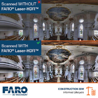
A New Standard in HDR Photography
The new FARO Laser-HDR™ (patent pending) feature in SCENE 2018 improves on conventional multi-exposure HDR techniques by intelligently combining a laser scan image and a photograph through a proprietary FARO process. This results in a laser enhanced HDR image in breathtaking color and detail in even the most challenging environments. This advanced feature is fully backwards compatible and thus allows all generations of FARO Focus Laser Scanner products to achieve exceptional HDR results in a considerably shorter amount of time. Finally, even as recording time (5X faster than traditional HDR) and data volume are dramatically reduced (150 MB per scan), all image details are captured in a single shot and the functionality can be used even if the laser scanner does not support HDR by default.
Increased Productivity Through High Detail Scanning
Defined areas, such as registration marks, can now be recaptured in higher resolution at a great distance from the same scanning position. FARO Focus S150 and S350 users now benefit from significant time savings on site, at least 1.5X faster than when it was required to perform high-resolution scans continuously. Furthermore, since the registration workflow is now fully automated (i.e., no manual interaction needed to process high detail scan data on an onsite PC/workstation), in-field and in-office productivity is improved even more substantially.
Efficiency Through Full Color Panoramic Images
SCENE 2018 enables a full camera resolution color image to be exported, independent of scan resolution. In those situations where high resolution color is required but high resolution scan is not, time savings of up to 80% can be realized.
Improved Performance and Stability
Scan quick views now open significantly faster and users can be ready to work with the data in half the time than before. Scan projects can be exported up to 75% faster to be shared more efficiently with project stakeholders via the FARO WebShare Cloud and SCENE 2go platforms.
Enhanced Virtual Reality (VR) Experience
SCENE 2018 builds on the VR base first introduced on SCENE 7.1 in 2017. First, it enables an even more natural, immersive experience with significantly fewer instances of motion sickness based on rigorous user testing. Next, it enables a more cost effective VR use case as it now offers improved compatibility with mid-priced Microsoft Mixed Reality Headsets. Together these improvements are expected to facilitate greater adoption of VR-enabled SCENE as a workflow efficiency tool across the AEC industry.
“The improvements in SCENE 2018 and derived benefits for FARO long range scanners offer another significant contribution to enhancing quality and efficiency across the entire construction life cycle,” stated Andreas Gerster, Vice President – Global Construction BIM. “This is the next step to realize our vision of Traceable Construction™ by better capturing and processing reality in 3D and then by sharing information through seamless, tightly integrated best-in-class solutions.”
FARO is the world’s most trusted source for 3D measurement, imaging and realization technology. The Company develops and markets computer-aided measurement and imaging devices and software for Factory Metrology, Construction BIM, Public Safety Forensics, Product Design and 3D Machine.
The new FARO Laser-HDR (patent pending) feature in SCENE 2018 improves on conventional multi-exposure HDR techniques by intelligently combining a laser scan image and a photograph through a proprietary FARO process.
Quantum Spatial Supports Multiple Lidar Data Acquisition Projects for USGS 3D Elevation Program
Public and Private-Sector Coalitions Awarded 3DEP Funds through Annual Broad Agency Announcement (BAA), Which Opened August 31
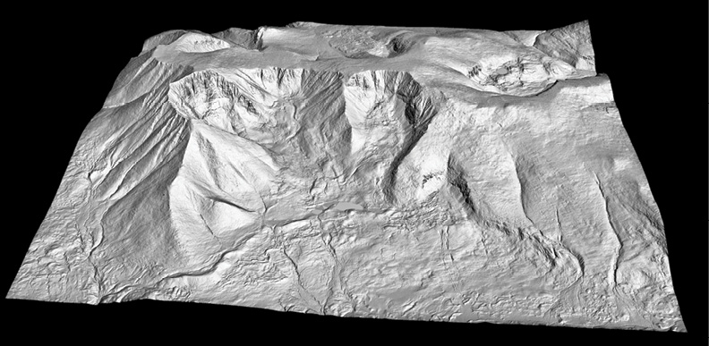
LiDAR-derived bare-earth model of Mount Katahdin, Maine.
St. Petersburg, Florida – August 21, 2018 – Quantum Spatial, Inc. (QSI), the nation’s largest independent geospatial data firm, announced that it is currently working on more than two dozen Lidar collection projects designed to address the country’s need for high-quality topographic data in support of the U.S. Geological Survey (USGS) 3D Elevation Program (3DEP) program. 3DEP, which provides matching federal funds for large-area Lidar collections that benefit multi-agency groups with common geospatial needs, opened its application process
on August 31, 2018, with a Broad Agency Announcement (BAA) for fiscal year 2019. Proposals will be due by October 26, 2018.
Since inception of the of the 3DEP program, QSI has worked with a diverse range of public agencies and private sector organizations seeking federal assistance to finance Lidar collections. In addition to providing Lidar survey and data analytics services, QSI also has fostered coalition building among disparate groups that have Lidar needs in the same geographic area, and provided guidance and support for project justifications, shared cost models and project specifications.
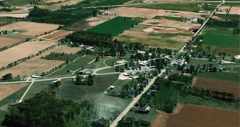
LiDAR point cloud, colorized with aerial imagery, of farmland in Door County, Wisconsin.
“QSI has been our trusted partner on 3DEP projects throughout the State of Wisconsin for many years. Together our firms have completed more than 20,000 square miles of Lidar surveys across the State,” said Jason Krueger, manager of Aerial Mapping at Ayres Associates. “As we move into the FY2019 project year, we look forward to working closely with them on additional projects that will bring the many benefits of the 3DEP program to participants at the federal and state level.”
3DEP Yields Real Community and Business Value
Working on 33 BAA projects since 2015, QSI continues to see how the Lidar data collected delivers value to the agencies, companies and other organizations in the geographic areas surveyed. Recent projects, awarded under the FY2018 BAA, include:
- North Slope Borough, Alaska – On the Arctic coast, this area is home to eight communities, and subject to increasing erosion, flooding and subsidence that has been exacerbated in recent years by melting permafrost and sea ice retreat. QSI worked with North Slope Borough officials to design the project scope and technical specifications and assisted with developing a cost share model. Now, QSI is in the process of collecting data across 458 square miles, which will provide a crucial baseline for monitoring the impact these changes have on infrastructure, as well as support emergency response efforts and assessment of gravel resources for infrastructure projects.
- Wisconsin Land Information Program (WLIP) – WLIP, working in partnership with the counties of Fond Du Lac, Calumet, Waupaca, Green Lake, Clark and Price, is undertaking a survey of 4,791 square miles, including the last four counties in Wisconsin without Lidar coverage. The elevation layer data will be used by the Federal Emergency Management Agency (FEMA) for floodplain delineation projects, as well as by the Environmental Protection Agency and county land conservation offices for watershed/pollution monitoring. It also will benefit other federal and state agencies, tribal organizations, private businesses and individuals for planning and zoning, land conservation, utilities, roads and economic development activities. QSI is partnering with Ayres Associates to design and complete this latest component of an ongoing multi-year program to complete Lidar coverage throughout Wisconsin. This partnership has expanded dramatically since 2010, resulting in cost savings and better data sets for all participants.
- Crown of Maine – Since 2010, QSI has performed several Lidar projects, including four 3DEP BAA-funded projects covering more than 23,500 square miles throughout Maine. The most recent project is with the Maine GeoLibrary and Maine Office of GIS, for which QSI will acquire Lidar data across 6,691 square miles to complete the GeoLibrary’s long-term plan to achieve initial statewide coverage. The project is supported by several partners, including the Baxter State Park; Town of Carrabassett Valley, Maine; Cooperative Forest Research Unit; Maine Bureau of Parks and Lands; Maine Center for Disease Control and Prevention: Maine Department of Transportation; Maine Geological Survey; the Nature Conservancy; Pattern; State of Maine Emergency Management Agency; Sunrise County Economic Council; USGS; USDA’s Natural Resources Conservation Service Maine office; and private landowners. The GeoLibrary is leveraging the Lidar data to support widespread public distribution of geospatial information. Data will be used to modernize local government land records, promote innovative uses of public information for economic development and reduce costs.
- Prince of Wales Island, Alaska – In an earlier BAA award, QSI surveyed 2,055 square miles of Prince of Wales in Alaska, through a project for The Nature Conservancy, U.S. Forest Service, Sealaska and Natural Resources Conservation Service. Working on phase two of the project in 2018, with additional partners the Metlakatla Indian Community and Organized Village of Kake, QSI will survey the southeast portion of the island, which is dominated by closed-canopy, coniferous forest and steep slopes. The project will assist ongoing U.S. Forest Service land management programs, measure current and future timber availability, aid in economically critical fish management studies, evaluate transportation infrastructure, detect geologic hazards, and characterize cultural heritage and mining sites. In addition to doing conducting the survey, QSI was instrumental in helping The Nature Conservancy develop the project and a cost share model, organize groups with similar interests to join the project, and draft the BAA proposal.
“The 3DEP program is unique in that it helps federal agencies, as well as state and local governments and private organizations, minimize their costs for collecting valuable geospatial information, while maximizing its impact for a variety of uses – including flood risk management, wildfire management, planning and response, natural resources conservation, coastal and riverine protection, infrastructure management and geologic resource assessment,” said Michael Shillenn, vice president at QSI. “QSI is proud of our work helping foster these collaborative partnerships and providing the advanced surveys and data analytics that deliver insights into our country’s constantly changing natural and constructed features.”
Organizations or agencies interested in learning more about the 3DEP program and how QSI can help, download this information sheet or contact Michael Shillenn at mshillenn@quantumspatial.com or Oriane Taft at otaft@quantumspatial.com.