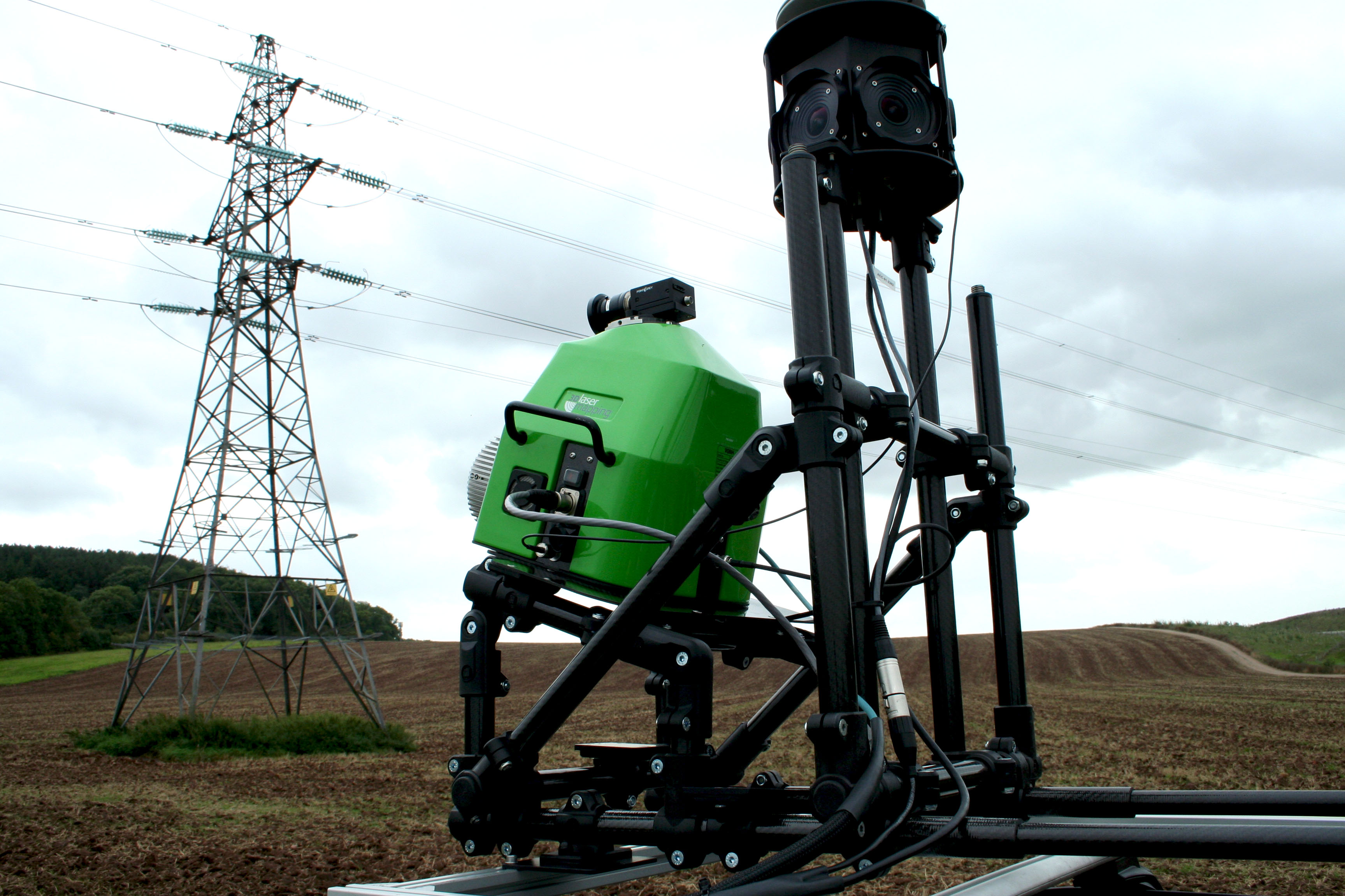
The ROBIN mobile mapping system in DRIVE mode.
The rising popularity of surveys using UAVs has led to great advances in photogrammetric techniques. Airborne lidar, however, still leads the way when it comes to collecting data across large geographical areas where elevation data is critical in places where foliage and vegetation can obstruct a standard camera’s view. Madeleine Lake, lidar systems engineer at geospatial technology provider 3D Laser Mapping, based in Nottingham, UK, discusses how airborne lidar facilitated the successful mapping of varied terrain in Manitoba, Canada.
Editor’s note: A PDF of this article as it appeared in the magazine is available HERE.
The importance of Manitoba’s highways cannot be overstated. 95 per cent of goods moved within the province depend on trucks and the trucking industry contributes more than $2 billion annually to Manitoba’s GDP. Thus the upkeep and maintenance of the 19,000-kilometer provincial highway system is of paramount importance to the economy in Canada.
Once known colloquially as the `postage stamp province’, Manitoba is located in the geographical centre of Canada and is the fifth most populated province, with varied terrain that spans nearly 650,000 square kilometers. Manitoba is one of the three prairie provinces of Canada and its rural environment comprises mostly open grassland used to graze cattle and grow grain crops. The flat landscape, coupled with the high water levels, makes the area prone to devastating floods. In April 2017, several communities were severely affected by flood waters, leading to many of the area’s highways being closed.
The geomorphology in Manitoba is complex for surveyors thanks to its glacial origins and the natural drainage of the ancient Lake Agassiz, which produced a flood of 150,000 km3. This drainage is thought to have covered as much as 440,000 km² of Manitoba, Ontario, Minnesota, North Dakota and Saskatchewan.
One of the most important considerations for highway engineering, especially in high-risk flood areas, is the collection, transportation and disposal of water. Approximately a quarter of all highway construction money is spent on the creation of culverts, bridges and other drainage structures to help ensure roads don’t become waterlogged and remain open for public use. Waterlogging can cause severe damage to road surfaces as well as prove costly in terms of disruption to services. With more than 110,000 lakes accounting for around 15 per cent of the province’s surface, it’s easy to see why hydrology is of high importance for those planning and maintaining critical infrastructure in Manitoba.
With this in mind, when Aquatics Environmental Services Inc. (Aquatics ESI), which specializes in collecting geospatial data in challenging environments, was tasked with surveying a flood-prone stretch of 100 km of Manitoban highway, it decided that an in-depth, progressive and cost-effective surveying method was required. Airborne lidar was the only logical solution.
By using a unique mobile mapping system, ROBIN, from 3D Laser Mapping, surveying teams can deploy different mounts depending on the applications and the survey environments. The backpack mount allows ground level surveys to be completed in areas which can be difficult to access, such as railway sidings and forests. It was the vehicle option, however, combined with the ability to mount the system on a helicopter, that appealed to the team at Aquatics ESI.
When installed on a manned helicopter, laser scanners allow operators and surveyors to gather highly detailed data sets from above, across a wide area. This level of unimpinged access is ideal where access to the site is limited, for example coastal areas and rural environments, and where accurate measurements are needed of complex infrastructure such as powerlines.
Aquatics ESI had previous experience of lidar technology, having carried out many hydrographic surveys using a combination of terrestrial laser scanning and sonar. Having been given a remit of covering a 200 m swath, detailing drainage ditches and culverts on either side of the highway, the survey team needed a system which could deliver high-resolution data in areas inaccessible on foot.
Rapid deployment and surveying speed were the most influential factors when it came to choosing survey equipment and sensors. The ability to deploy a helicopter ultimately saved time which would have been spent surveying the large area by other means. Nevertheless, the remit also required a certain point-cloud density to be collected, which would need to be facilitated by a vehicle-mounted system.
The target of Aquatics ESI’s survey was a stretch of highway close to the town of Lac du Bonnet, 115 km northeast of Winnipeg, on the west shore of the Winnipeg River (see map). Each year, officials struggle to maintain road networks such as this, which suffer from flooding, made worse by winter conditions below freezing, where culverts often become blocked with ice.
The Aquatics ESI survey team started by mounting ROBIN to a road vehicle. The highway was mapped in two passes whilst the road remained open to normal traffic. The team then moved to the nearby regional airport, where the system was transferred to a helicopter.
One of the major benefits of using airborne lidar is the speed at which data can be collected. The ROBIN +WINGS helipod facilitated a seamless transition from DRIVE mode into FLY, with the system connected directly into the helicopter’s power supply, which enabled scans of extended duration to be carried out. The same 100 km of highway was then remapped at an altitude of 100 m, at speeds of around 75-100 kph. Only two passes were needed, so the airborne scan was completed in less than 90 minutes.
The airborne data captured amounted to 20 GB of scanner data and 122 GB of raw image data, which was stored on the onboard datalogger for future processing and analysis. The ability to use ROBIN to scan the highway from the road as well as from above allows two datasets to be combined, providing the level of detail needed by planning and maintenance teams to assess weaknesses in the drainage systems.
When processed, the datasets from both the airborne and vehicle scans were matched together with an accuracy of between 1 and 2 cm. The noise on the roadbed was measured at 3 mm from a single drive pass and approximately 5 mm when the datasets were combined, without any control points in place.
Because both the helicopter and drive data had good absolute accuracy it was a straightforward task to merge the datasets. Since the drive data was the more accurate, this was used as reference data and the helicopter data was matched to it in height only (xy mismatch was minimal). This is an automatic process.
Airborne laser scanning offers an unrivalled perspective for mapping and surveying large or difficult-to-access locations and flexible, multi-use mobile mapping systems have become an invaluable tool for almost any type of survey.
The popularity of UAVs will continue to surge due to their ease of use and cost effectiveness. For large-area challenges, however, manned helicopters and light aircraft are needed and this is where multi-use mapping systems can show true value.
Madeleine Lake worked in Australia for three years as a geologist using geospatial datasets in a gold exploration and mining setting. Her MSc project used aerial LiDAR data for structural analysis of the Matano Fault in Sulawesi, Indonesia. Madeleine joined 3D Laser Mapping in February 2017 and is a technical member of the sales team.
Sidebar:
ROBIN System
Airborne lidar systems are traditionally only suitable for being mounted on to aircraft. ROBIN +WINGS takes the flexibility of the standard ROBIN system to new heights, with a simple-to-perform transition between WALK, DRIVE & FLY functions.
ROBIN +WINGS integrates the standard components of the ROBIN system with an extended capacity hard drive and control unit, which allows the system to be powered by the aircraft’s power supply. The addition of three PhaseOne aerial cameras enables enhanced imagery to be collected to support the creation of high-density point clouds backed up by highresolution georeferenced images.
The ROBIN system’s flexibility means that data sets can be combined from WALK, DRIVE and FLY surveys, providing accurate and detailed information from both the ground and air.
The +WINGS add-on works with both single pole and nose helicopter mounts and can improve surveying results in a range of sectors, including forestry, environmental monitoring and transportation infrastructure mapping.
For more information about 3D Laser Mapping’s ROBIN system, visit: 3dlasermapping.com/robin-mobile-mapping-system
Sidebar:
3D Laser Mapping
3D Laser Mapping is a world leading geospatial technology supplier and innovator. Underpinned by two decades of experience, the company provides 3D technology across the UK, South Africa, USA and Australia via its network of branch offices and international distributors.
Working alongside some of the world’s biggest mining companies, governments, universities, blue-chip firms and operators of highways, power lines and railways, 3D Laser Mapping helps its customers to capture and understand their world in 3D.
The findings from mapping and monitoring are used to guide decision-making based on reliable, high quality measurements.
As well as providing cutting edge technology, technical support, training and consultancy services, 3D Laser Mapping’s in-house research and development hub leads the way in product innovation.
For more information, visit 3dlasermapping.com