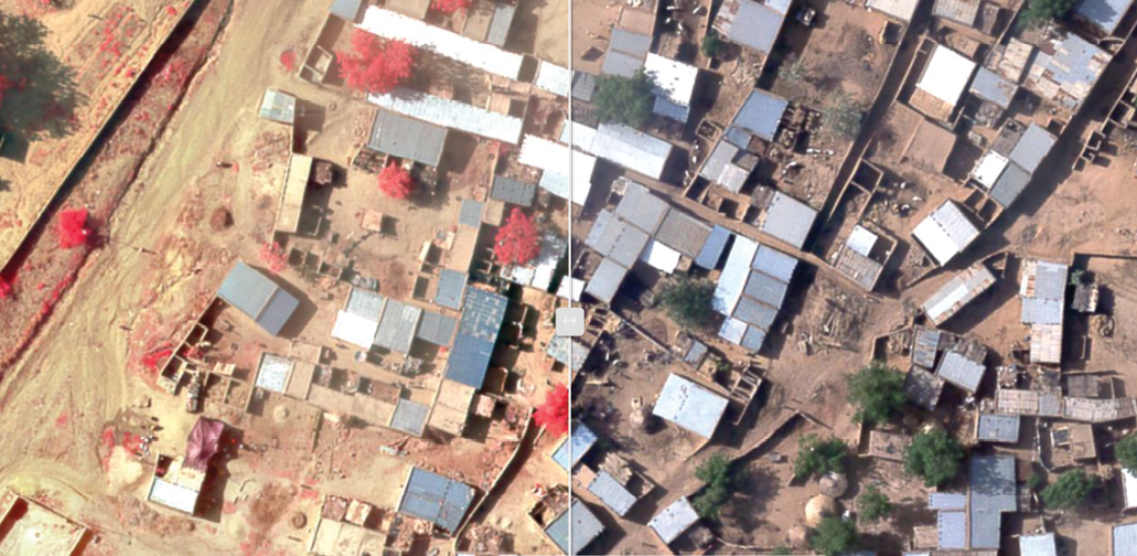
A large-format, four-band, 12-bit sensor acquired color infrared stereo imagery for high-altitude image collection. Digital imagery collection was completed within seven hours following 20 multispectral imagery data flight lines. Courtesy of Woolpert
The Millennium Challenge Corporation (MCC) is an independent, U.S. foreign-aid agency that invests billions of dollars in partnerships with some of the world’s poorest countries to combat global poverty. The agency, created by the U.S. Congress in 2004, targets developing countries that are committed to good governance, economic freedom and citizen investment.
MCC supports these countries by installing an infrastructure critical to growing an economy and building resilience. To do this in these rural regions means ensuring that households and farms have reliable access to water and power, and businesses have dependable roads to connect with customers’ expanding markets. This requires high-resolution imagery to understand each country’s current conditions and to create a detailed, efficient plan to make each economy productive.
In 2016, for its work with the Republic of Niger, Africa, MCC contracted with Woolpert for a mapping project that required rapid deployment and the delivery of accurately and efficiently collected data and imagery. This data and imagery would enable the MCC to partner with Niger to provide data for irrigation development planning and road rehabilitation to bolster its agricultural sector, which employs roughly 80 percent of the country’s population. Greg Fox, Woolpert geospatial program director, said the project entailed conducting ground survey and acquiring aerial lidar and four-band imagery of 651 square kilometers in the Dosso-Gaya regions along the Niger River and on select road sectors throughout the country, all within a short time frame. “The project had multiple challenges, including international logistics and travel constraints, significant security concerns and tight deadlines,” Fox said. “Fortunately, we were able to mobilize within seven days of being awarded the contract, and quickly get en route to helping MCC improve the agricultural future of the region, which would eventually benefit almost four million people.”
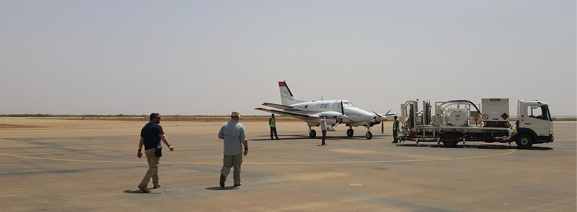
Woolpert based its flight operations at Diori Hamani International Airport, where the team mobilized its aircraft with the lidar system to prepare for aerial data collection. Courtesy of Woolpert
Deploying to Niger, Adapting to Location
For the Niger project, the Woolpert team furnished the facilities, labor, materials, equipment and aircraft, and handled all landing permits for the transit. Two pilots, including one who was a certified mechanic, also made the seven-day trip.
An advance site survey group was sent to identify adequate accommodations and ground logistics. Once in Niger, the deployed team met with local MCC representatives and other government officials to start the effort. Woolpert engaged with an indigenous company to support ground control surveys.
“Not everything went smoothly,” Fox said. “Red tape often resulted in delays accessing the survey area and even our own aircraft.”
Each morning, a GPS base station was set up at designated locations in the survey area to support the ground control and aerial survey missions for the day. GPS base station data was collected once per second all day. The ground control survey team had to establish coordinates to support imagery acquisition. The team installed and GPS-surveyed photo control targets and lidar control points throughout the project area. In a few locations, the planned sites had to be repositioned.
“We used open-source imagery for selecting our proposed ground control locations,” Fox said. “For the most part, our preselected locations worked out well; however, we did come across a few locations with access issues or locations that posed a safety concern, for which alternatives had to be used.”
Ground crews split into two teams, working from one end of the linear study area to the other, to cover more ground and to place all targets before the aerial imagery acquisition began.
Clear skies for aerial acquisition
Flight operations were based in Diori Hamani International Airport, near the Niger capital city of Niamey, where the team mobilized its aircraft with the lidar system to prepare for aerial data collection. The scope of work required highly accurate lidar with nominal point spacing of no greater than 0.5 meters to produce classified point clouds, bare-earth digital elevation models (DEMs), breaklines, contours and model key point digital terrain models.
The project entailed conducting ground survey and acquiring aerial lidar and four-band imagery of 651 square kilometers in the Dosso-Gaya regions along the Niger River and on select road sectors throughout the Republic of Niger. Courtesy of Woolpert.
Fox said the weather was perfect for data collection. “The day the team arrived, a dust storm came through followed by rain, which removed all the remaining dust from the air,” he said. “We were really lucky.”
Operations began on a Monday and were completed by Thursday after seven flight missions, five lidar and two imagery acquisitions. Once the lidar collections were completed, the team quickly uninstalled the lidar sensor from the plane on the runway and began installing the camera system—a large-format, four-band, 12-bit sensor that acquired color infrared stereo imagery for high-altitude image collection.
When the camera system was installed, the team immediately set out for the aerial imagery acquisition at 15-cm pixel resolution. The digital imagery collection was completed within two days.
Processing the Product, Value of Information
Upon completion of the aerial survey mission, the team immediately processed the aerial lidar data, along with the GPS and inertial measurement unit (IMU) data, to produce a raw point cloud for coverage and quality validation.
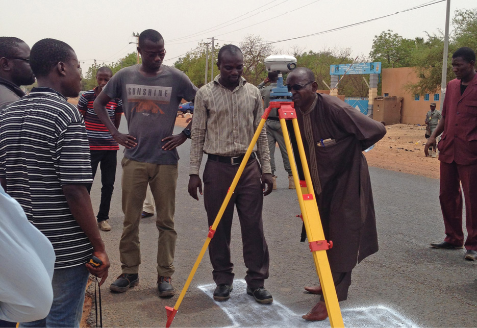
Cross-shaped targets were painted on pavement for the ground control survey if points fell on paved roadways. Courtesy of Woolpert
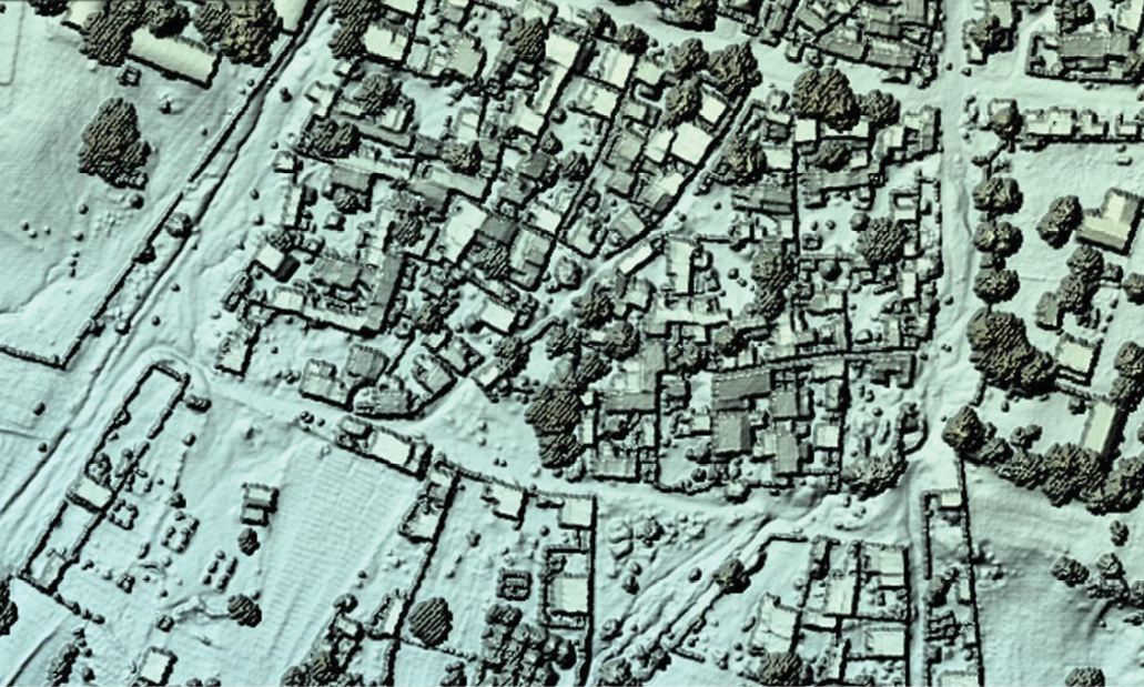
Back in the U.S., the point cloud was calibrated and classified into ground and non-ground points to eliminate lidar returns for buildings and vegetation from the bare-earth surface model. All non-ground points then were classified as buildings and vegetation. Team members produced the following lidar products: a bare-earth DEM, a classified point cloud, breaklines generated along all defined water bodies and along defined road edges where required to support DEM generation, contours, and a model key point digital terrain model with edge-joined tiles, made seamless with the project area. The multispectral imagery was processed into a seamless RGBN-band mosaic. The software automatically removed unwanted images. In its final form, the mosaic was cut into edge-matched delivery tiles, with special care taken to identify distortions around bridges, overpasses, water towers and radio towers. All lidar and DEM products were delivered within three weeks.
Fox said the geospatial data produced for this project is sufficient for numerous planning and engineering studies related to MCC’s projects in the area. The imagery provides valuable land use and environmental information that can help planners and engineers determine potential environmental impacts. The lidar elevation data can be used to determine cut and fill volumes related to roadway construction, as well as for drainage and even floodplain modeling.
“Data of this quality, resolution, accuracy and timeliness can only be provided from aerial platforms and skilled surveying and mapping professionals,” Fox said. “And being able to work effectively within the environment is another skillset necessary to make these projects possible.”
Lessons Learned, Moving Forward
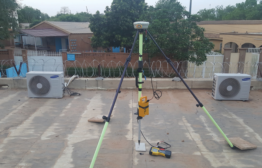
Each morning, a GPS base station was set up at designated locations in the survey area to support the ground control and aerial survey missions for the day. GPS base station data was collected once per second all day. Courtesy of Woolpert
Fox said conducting international lidar projects requires adjustment due to local and host nation requirements and protocols. He noted a few general recommendations to make these projects progress smoothly.
- Allow sufficient time to plan the trip details before arriving in the country. Pre-planning can help determine a local agent who will look out for your interests and not take advantage of your team.
- Determine the best solution for transporting equipment. Fox said the camera’s on-board computer and components were checked as luggage to minimize weight on the aircraft during transit.
- Confirm verbal permission to fly in the country before securing paperwork. Local holidays and/or the whims of local officials may stymie plans. “We were able to secure verbal permissions to conduct our aerial survey mission, but we never received the official letter granting our flight permit until all data collections were complete,” Fox said.
- Be courteous to officials. The team made a point to visit the governor and the sultan, who handles tribal issues, to inform them about their presence in the country and what the mapping project would entail.
Despite the inherent challenges of the project, Fox said the team completed the ground and aerial survey project ahead of schedule and presented accurate, valuable data to MCC to advance its irrigation development planning and road rehabilitation project.
The groundbreaking Niger Sustainable Water and Agricultural Compact, which was signed in 2016 and came into force on 26 January 2018, was the first agreement MCC signed with the country of Niger, which is mostly covered by desert. Establishing and maintaining access to water and transportation helps a country begin to help lift itself from years of severe food insecurity.
Fox noted that, due to the expense involved in mobilizing aircraft, sensors and personnel to conduct aerial surveys in parts of Africa, including Niger, these resources should be leveraged to map the largest possible area for multiple applications. He said this project was the impetus for Woolpert to campaign to work with host nations, MCC and other multilateral aid organizations to think about regional- and national-scale mapping programs. Fox said he was pleased to be a part of this project and the work of the MCC.
“Developing countries are especially interested in taking the next step to become economically self-sufficient and provide security and a future for their people,” Fox said. “We are proud to be able to provide this necessary, high-quality mapping that can make a difference in the lives of people whether they’re in our backyard or around the world. Participating in a project to help build a foundation for economic growth and food security for an entire nation is especially gratifying.” 
Tim Leary is a Geospatial Program Director in Woolpert’s National Security market, bringing hands-on geospatial experience and his passion for innovation to clients in the military, the intelligence community, government and the private sector. He is a member of the American Society for Photogrammetry and Remote Sensing (ASPRS) and the U.S. Geospatial Intelligence Foundation (USGIF).