RIEGL Invests in New Office and Production Facilities
New, additional facility expansions at the headquarters in Austria as well as a new facility in the United States.
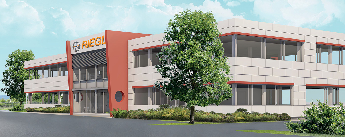
New production facility in Horn, Austria.
RIEGL, an internationally successful manufacturer of LiDAR scanners for surveying applications headquartered in Horn, Austria, is investing heavily in the expansion of production and office space. The continued, worldwide demand for the high-performance sensors allows the company to grow and expand further.
RIEGL, which celebrated its 40th anniversary last year, is now meeting the rapidly increasing international demand for RIEGL laser scanners with office and production facilities expansions.
This summer, a new office and production facility has started construction at the location of the company’s headquarters in Horn, Austria. The new building will house the company’s printed circuit board production and the software development team. The additional area comprises more than 2200m2 (24,000 sq foot) on three floors and will offer space for up to 80 employees. A state-of-the-art measuring tunnel system with a length of over 100 meters will also be built and be used for testing and calibrating the RIEGL sensors. The buildings will be ready for occupancy in fall of 2020.

Future RIEGL USA North America Office in Orlando, Florida, USA.
RIEGL is also continuing to grow in the United States. The company has been active and successful in this market for more than 25 years and is currently building a new North American office facility in Winter Garden, Orlando, Florida, offering 1500m2 (16,000 sq foot) floor space. The building will offer trendy and modern workplaces for up to 50 employees. In addition to office space, the new RIEGL USA Headquarters will also allow the company to expand in the areas of support, service and calibration for the complete RIEGL portfolio. The building will be ready for occupancy Fall of 2020.
Throughout the building process, state of the art RIEGL technology like the RIEGL VZ-400i Terrestrial Laser Scanner as well as VUX-based LiDAR mapping drones will be applied regularly to support, monitor, and document the construction processes.
In total, the investment volume for the expansion of the company’s facilities in 2019 and 2020 is more than 10 million EUR.
“Our investments in Austria and the US prove our path of success and the growing internationality of the company” explained Dr. Johannes Riegl, founder and CEO of the RIEGL Group, and his son, Johannes Riegl Jr., member of the management board and President of the US division of the company.
RIEGL—a privately-owned company with subsidiaries in the US, Japan, China and Australia—has grown continuously over the past years. In the last fiscal year, RIEGL achieved a record group turnover of more than 80 million EUR with 250 employees worldwide.
RIEGL is an international leading provider of cutting-edge technology in airborne, mobile, terrestrial, industrial and unmanned laser scanning solutions. RIEGL has been producing LiDAR systems commercially for more than 40 years and focuses on pulsed time-of-flight laser radar technology in multiple wavelengths. From the first inquiry, to purchase and integration of the system, as well as training and support, RIEGL maintains an outstanding history of reliability and support to their customers. Worldwide sales, training, support and services are delivered from RIEGL’s headquarters in Austria, main offices in the USA, Japan, China, and Australia and by a worldwide network of representatives covering Europe, North and South America, Asia, Australia, and Africa. For more information, please visit riegl.com
Woolpert First Provider Approved by PennDOT to Operate Drones for State Projects
The Pennsylvania Department of Transportation requires UAS operators to undergo extensive PennDOT training in addition to attaining the FAA’s Part 107 Remote Pilot Certificate.
Harrisburg, Pa. (July 9, 2019) — Woolpert had numerous surveying, mapping and geospatial professionals complete the Pennsylvania Department of Transportation’s (PennDOT) Unmanned Aircraft System (UAS) training July 2. The training is part of PennDOT’s certification process, along with attaining a Part 107 Remote Pilot Certificate through the Federal Aviation Administration (FAA), for contractors who use drones on state projects. Woolpert became the first provider approved.
Woolpert Chief Scientist Qassim Abdullah, Geospatial Practice Leader Tom Ruschkewicz and UAS Technology Manager Aaron Lawrence were among those who attended the training. Lawrence, who was one of the first in the country to earn his Part 107 license in 2016, is now a certified PennDOT UAS operator.
Abdullah, a certified photogrammetrist and licensed professional surveyor and mapper, is an adjunct professor at Penn State University who has taught multiple courses on UAS capabilities. Ruschkewicz has decades of transportation surveying and geospatial experience and is very active in the state of Pennsylvania.
“As we continue to enhance our service offerings in Pennsylvania, we found the training extremely valuable in gaining a better understanding of how PennDOT wants to use UAS and the expectations they have for safe and successful operations,” Ruschkewicz said.
“Woolpert is leading the way within the geospatial industry for best practices and product quality assurance when it comes to using UAS for PennDOT and other transportation agencies,” added Abdullah, who also has written several articles on bridging the gap between the professional mapping community and UAS operators.
Lawrence said this certification is an example of the multiple state and national efforts underway to safely integrate UAS into national airspace. It also illustrates the variety of measures being taken by individual state agencies to ensure UAS safety for third-party operators, workers and the public.
“The commercial use of drones is moving in the right direction, as evidenced by the many required UAS qualifications,” Lawrence said. “We hope to see these safety and proficiency standards become universal; however, it is important to understand that each state has its own regional and environmental concerns. In the meantime, we at Woolpert will continue to ensure our staff is proficient in UAS applications in general and in those specific to each agency’s needs. It’s what we do.”
Woolpert was the first surveying and mapping firm to be approved by the FAA to fly UAS commercially in designated airspace through its Section 333 exemption in 2014. Since then, the international architecture, engineering and geospatial (AEG) firm has supported a wide variety of projects utilizing UAS, has invested in numerous UAS platforms and employs 18 FAA Part 107 certified pilots.
Woolpert is committed to a vision to become the premier architecture, engineering and geospatial (AEG) firm, and one of the best companies in the country. It’s a vision we’ve been fine-tuning for decades. It guides our decisions and investments, provides our clients with optimal solutions, and offers our employees unrivaled opportunities. Woolpert is recognized as a Great Place to Work by its employees and is America’s fastest growing AEG firm. With more than a century of experience, close to 1,000 employees and 30 offices, Woolpert supports public, private, federal, and military clients nationally and around the globe. For more information, visit woolpert.com and connect with us on LinkedIn, Twitter and Facebook.
GeoCue Introduces True View, The Industry’s First Drone Lidar/Imagery Fusion Sensor
![]() Nashville, TN – GeoCue Group Inc. unveiled its new True View™ line of drone sensors at an invitation only industry event on June 25th in Nashville, Tennessee. True View sensors offer surveyors an innovative lidar + dual oblique mapping camera configuration integrated in a single lightweight payload for use on commercial drone platforms. True View allows for fast, easy automated generation of true 3D colorized point clouds, oblique imagery and orthophotos from a single flight.
Nashville, TN – GeoCue Group Inc. unveiled its new True View™ line of drone sensors at an invitation only industry event on June 25th in Nashville, Tennessee. True View sensors offer surveyors an innovative lidar + dual oblique mapping camera configuration integrated in a single lightweight payload for use on commercial drone platforms. True View allows for fast, easy automated generation of true 3D colorized point clouds, oblique imagery and orthophotos from a single flight.
In addition to a complete system presentation and software demonstrations by GeoCue, guest speakers included:
- Lori Eversull of Vulcan Material Corporation, presenting an engaging discussion of how drone sensor technology is used in Vulcan’s mining operations.
- Srdjan Sobol, Development Manager for Applanix (a Trimble company), presented the three Applanix/Trimble positioning solutions offered by True View’s local or cloud-based positional post-processing workflows.
- Andreas Ploier, CEO of Drone Rescue Systems, discussed the new partnership with GeoCue and the value of a rescue parachute when operating in environments with persons as well as protecting high value payloads.
- My-Linh Truong, UAS segment manager for Riegl, who discussed the new Riegl partnership with GeoCue and the characteristics of the upcoming True View 610’s Riegl miniVUX sensor.
- Tyler Crawford of MFE Insurance Brokerage who provided an overview of insuring drones and drone sensors.
Press coverage was provided by Mr. Allen Cheves and Dr. Stewart Walker of LIDAR Magazine.
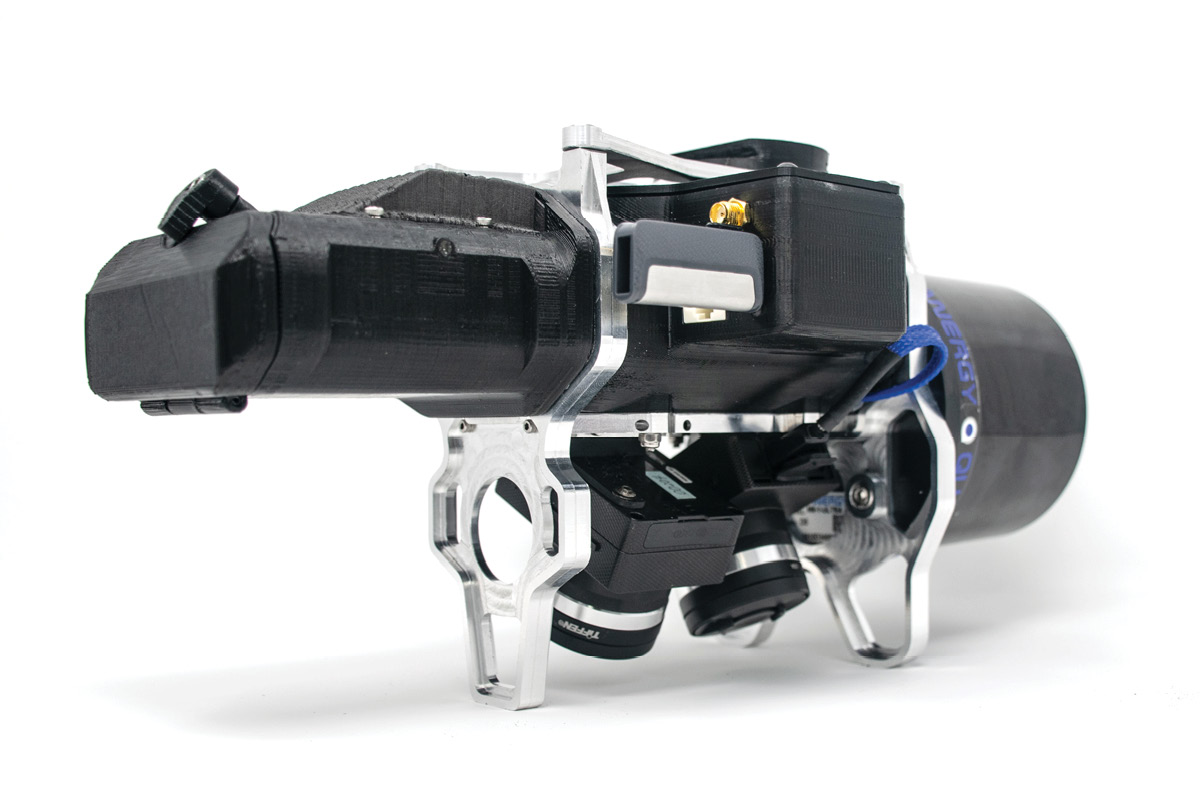 The first sensor of the product line, the True View 410, was displayed at the reveal along with full workflow processing in the companion True View Evo processing software. The True View 410 is the industry’s first integrated LIDAR/camera fusion platform designed from the ground up to generate high accuracy 3D colorized LIDAR point clouds. Featuring dual GeoCue Mapping Cameras, a Quanergy M8 Ultra laser scanner and Applanix Position and Orientation System (POS), the result is a true 3D imaging sensor. With its wide 120° fused field of view, the True View 410 provides high efficiency 3D color mapping with vegetation penetration in a payload package with a mass of about 2 kg.
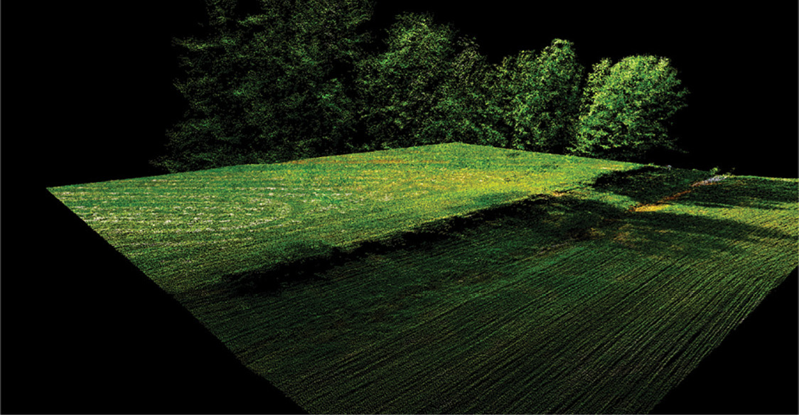 Demonstrations of True View Evo full post-processing workflow software (included with the sensor) were provided. The audience witnessed the creation of stunning 3D colorized point clouds with processing time from sensor to final product of less than 15 minutes for a 50-acre site. The visualization of colorized vertical surfaces demonstrated the value of the dual oblique cameras and true 3D mapping of LIDAR points to images.
“Anyone considering a drone LIDAR system should pause and evaluate the True View product line,” said Lewis Graham, President and CTO of GeoCue. “The True View sensor fusion systems will make 3D colorized point clouds a standard product demanded by customers of high accuracy drone mapping. The 3D colorization approach that we use in our Evo software provides a new level of intelligence in LIDAR point clouds. An advance in sensor technology comes along every few years that changes our industry – True View is one of those instances.”
 In addition to its advanced fusion technology, the True View 410 includes a revolutionary business model option. Customers can purchase the complete system (hardware and full workflow software) as a standard purchase or enroll in a subscription service. For as little as $3,000 per month, a user can obtain an Evergreen True View 410 with complete processing software. The minimum time commitment for an Evergreen subscription is 3 months. The base subscription includes enough processing minutes to complete about 20 projects of 50 acres each. Additional processing is purchased by the minute. Both traditional purchase and Evergreen customers can access Applanix SmartBase and Trimble PP-RTX on a per-minute basis (via True View Evo) without the need to commit to an annual Trimble service subscription; all billing is managed by GeoCue.
The True View 410 beta program begins in July with customer shipments to follow. Contact GeoCue at 1-256-461-8289 or info@geocue.com for detailed system information.
GeoCue Group was founded in 2003 by a group of engineers with extensive experience in developing hardware and software solutions for primary remote-sensed data acquisition. Our initial products were aimed at reducing schedule and cost risk in geospatial production workflows by providing organizational, productivity and data management tools for base geospatial data production. These tools have been realized as the GeoCue product family. Today GeoCue workflow management tools are used by a majority of North American geospatial production shops. In 2005, GeoCue began selling and supporting Terrasolid tools for kinematic LIDAR data production. This was followed in 2009 by our acquisition of QCoherent Software LLC, the creator of the point cloud exploitation toolset, LP360. Today GeoCue is the largest supplier of kinematic LIDAR processing tools in North America and LP360 is the world’s most widely used tool for exploiting point cloud data. In 2014, GeoCue Group started a division focused on using small Unmanned Aerial Systems for high accuracy mapping. Leveraging our expertise in production, risk reduction, and point cloud processing tools, we are continuing to bring new services and products to market to provide surveyors and other geomatics professionals exciting tools for geospatial data extraction using low cost drones including Loki, our plug-and-play PPK direct positioning system, and now our new True View LIDAR/Imagery fusion sensors. To learn more, visit geocue.com.
Cepton Names T. R. Ramachandran as Executive Vice President of Marketing
Twenty-year industry veteran will lead Cepton’s global product and corporate marketing
San Jose, Calif.–Cepton Technologies, Inc., a provider of 3D lidar solutions for transport, automotive, IoT, industrial, security and mapping applications, today announced the appointment of Dr. T. R. Ramachandran as Executive Vice President of Marketing. Reporting to Dr. Jun Pei, Cepton’s co-founder and CEO, Ramachandran will be responsible for managing product and corporate marketing activities, and driving the company’s continued leadership in the lidar industry.
Dr. Pei said: “T. R. Ramachandran is a seasoned technology executive with a deep background in marketing and new product introduction and has extensive experience in lidar. We are delighted to have him join our team. His experience working with the world’s top automotive OEMs and Tier 1s to introduce advanced lidar technology, along with his strong ability to drive product quality at high volumes, will be instrumental in enabling Cepton’s growth in the coming years. He will also apply his considerable financial acumen in partnership with Cepton’s CFO Bob Brown to fuel the next phase of our business growth. I look forward to working alongside him and welcome him to the team.”
Ramachandran joins Cepton from Velodyne Lidar, where he was Vice President of Product Management and developed a keen understanding of various applications for lidar, including autonomous vehicles and robots, mapping, security, industrial, IoT devices and more. He is a Silicon Valley veteran with strong experience both in innovative startups and larger companies. Among his prior roles, he was Vice President of Corporate Quality and Programs at LSI (now Broadcom), where he played a key role in the transformation of LSI into a $2.5B company and worked with the executive leadership team to pave the way for LSI’s acquisition by Broadcom (Avago) for $6.6B.
“Lidar is going to revolutionize the world across a variety of everyday applications. My top priority is to help Cepton become the lidar market leader, drive scalable growth and deliver affordable, high performance and superior quality lidar at large volumes to the world’s top automotive Tier 1s and OEMs,” said Ramachandran. “I echo our CFO’s observation that Cepton has developed a unique technology that will deliver the combination of performance, reliability and cost required for lidar to achieve mass adoption across a variety of industries. I have personally been impressed by the progressive and visionary leadership of Cepton’s CEO, Dr. Jun Pei, who combines path-breaking innovation, a strong customer focus and dedication to making lidar widely available and broadly affordable. I am excited by the opportunity to work with him and his experienced team to make Cepton successful.”
Cepton Technologies, Inc. is a 3D sensing solutions provider shipping state-of-the-art lidar products for the automotive, security, transport infrastructure, industrial, IoT and mapping markets. Founded in 2016 and led by industry veterans with deep experience in lidar and advanced imaging, Cepton is focused on the mass market commercialization of high performance, high quality lidar solutions for the automotive industry and beyond. Cepton’s patented lidar technology delivers outstanding detection range and resolution, reliability and affordability, to enable perception for the fast-growing market for autonomous and smart machines. For more information, visit: cepton.com