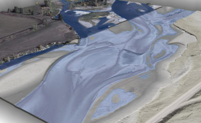
A view of braided bathymetry in the Kootenai River. This image is split between the topobathymetric bare earth model in the foreground, colored by elevation, and the above-ground point cloud in the background, colored using 10 cm RGB orthoimagery.Water’s edge breaklines are overlaid in a transparent blue to indicate submerged areas.
Modeling the bathymetry of rivers presents significant challenges for GIS professionals, as they try to model submerged terrain with the same accuracy and resolutions that they require for terrestrial landscapes. While boat-mounted sonar has worked to gather inland bathymetry data, it has limitations for shallow waters.
New technologies—such as topobathymetric lidar combined with hyperspectral imagery—present opportunities to analyze and model inland shallow water floodplains and riverine environments in ways not possible before. A U.S. Geological Survey (USGS) project, which started in Fall 2017, set out to evaluate the promise of these technologies for use in national mapping programs, and assess their ability to provide valuable new insights into water resource management and aquatic habitats.
USGS research and the Kootenai River
USGS contracted Quantum Spatial Inc. (QSI), which has been perfecting the use of these new technologies to map shallow river systems since 2012, to collect and process topobathymetric lidar, natural color imagery and hyperspectral imagery for a 54-mile stretch of the Kootenai River in northern Idaho. This complex endeavor was designed to provide USGS with a better understanding of the river, while evaluating the potential large-scale commercial value of new techniques for mapping inland bathymetry.

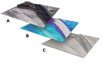
A layered view of high-resolution topobathymetric lidar models of the Kootenai River project. A. Lidar point cloud with orthoimagery drape. B. Hyperspectral analysis. C. Lidar -derived bare-earth and bathymetric elevation model.
USGS’s inland bathymetry research was instrumental in the evaluation phase, focusing on a diversity of pilot rivers to test the ability of topobathymetric lidar to characterize fluvial patterns and processes, and identify optimal conditions, as well as standardized collection and processing techniques. Because research and restoration activities were already underway, USGS identified the Kootenai River as a perfect pilot site to evaluate this approach.
The Kootenai River flows from its headwaters through a rugged region of southwestern Canada, then through Montana and Idaho, before meeting the Columbia River 500 miles later. The watershed drains a 19,000-square-mile area, spanning six different biomes. It supports a rich variety of flora and fauna, and is a primary source of drinking water and agricultural irrigation along its course. Given this diverse reliance on the Kootenai by fish, wildlife and humans alike, it has become a hotbed of research on fluvial processes, species protection, habitat enhancement, restoration, and flood dynamics for a collection of scientists, environmental groups, tribes and local communities.
Getting the project off the ground
The Kootenai River project was complex from the start, involving three technologies: lidar for topobathymetric data, simultaneously acquired natural color imagery for ancillary information, and hyperspectral imagery for depth and flow modeling. This combination created challenges for the flight team, which had to collect three disparate types of data within the same time frame. The deployment required outfitting and installing the hyperspectral sensor with the topobathymetric lidar (and camera) sensor into a single two-hole aircraft. This complex combination of technology included the Riegl VQ-880-G topobathymetric lidar sensor with an integrated 29 megapixel Prosilica GT6600 digital camera, and an ITRES CASI 1500H hyperspectral imagery sensor provided by USGS. The project was among the first riverine areas of interest to test the settings of the then new 1.5 Secchi Depth Riegl VQ-880-G system and its performance for modeling rivers in the Pacific Northwest.

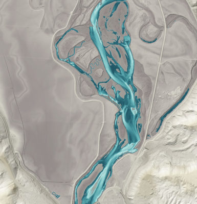
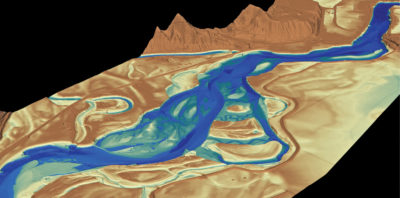
An integrated lidar-derived topobathymetric model showing the extensive river braiding, depicting both bare earth (grey) and subsurface bottom (blue) terrain.
The lidar sensor was set to collect data at QL1 pulse density of 8 pulses/m2 for topographic surfaces, and at least 2 pulses/m2 for bathymetric surfaces; the natural color imagery was co-acquired with the lidar at 10 cm GSD; and the hyperspectral imagery was collected at 50 cm pixel resolution.
Once the sensors were installed on the aircraft, QSI evaluated and optimized flight plans for the particular altitude, field of view and swath width required to meet specifications for terrain resolution. Utilizing one aircraft for a single deployment to the study area increased efficiency, and also significantly reduced costs.
The Kootenai project involved close collaboration between USGS scientists, University of Wyoming (UW) fluvial geomorphologists, River Design Group (RDG) restoration engineers, and QSI’s team of project managers, acquisition managers, flight team, ground crew and lidar technical experts. With a short six-day acquisition window of September 24-29, 2017, the team had to coordinate and collect all ground and airborne data among multiple partners in the proper order, while also working within the confines of weather.
To help understand drift patterns and larval fish dispersal, the hyperspectral imagery was collected during a specific window after release of a red tracer dye into the river. Owing to concerns that the dye would impact water clarity, however, lidar had to be collected first. All ground operations—measurements for turbidity, setting hyperspectral targets for ground control, release of the dye, setting lidar terrestrial and submerged QA points and waveform targets, and collecting verification depth profile and cross-section data (USGS)—had to be carefully timed and orchestrated with respect to each other and to the airborne flights. RDG, which was in the midst of a channel-bed dredging operation upstream of the Kootenai project site, also had to halt operations for 48 hours before and during the lidar collection to ensure there was no impact on turbidity from sediment disturbance.
With ideal river conditions in the forecast, a hold on sediment dredging, and a multi-agency ground team at the ready, the QSI acquisition team quickly collected more than 20,000 acres of topobathymetric lidar data and orthoimagery within a two-day window, then 12,851 acres of hyperspectral imagery two days later.

An integrated lidar-derived topobathymetric model showing the extensive river braiding, depicting both bare earth (grey) and subsurface bottom (blue) terrain.
Once the data was collected, lidar and orthoimagery were quickly processed in parallel for delivery by mid-December 2017. There were three different, but interdependent, workflows involving multiple subtasks and coordination among two firms to keep the post-processing workflow efficiently coordinated and on schedule.
QSI processed all lidar data and color natural imagery, which was orthorectified using the lidar-derived digital elevation model (DEM). There were many subtasks involved in topobathymetric lidar processing, including correction for light refraction through water, an evaluation of the impact of water clarity and surface reflectivity on results, and treatment of the waveform data. ITRES ran preliminary processing and quality control on the hyperspectral data, worked with the lidar-derived DEM provided by QSI for the orthorectification step and the ITRES proprietary geometric correction software, then passed the imagery to QSI for final processing and quality assessment.
All data was expected to meet requirements for data quality, resolution, accuracy and deliverables in the USGS’s Lidar Base Specifications Version 1.3 and the National Ocean and Atmospheric Administration (NOAA) bathymetric modeling standards. These were also requirements for meeting predictive model input requirements.
Lidar resolution was 11 points/m2 for bathymetric surfaces mapped and 8 points/m2 for combined topographic surfaces. The lidar elevation data was accurate to within 5.6 cm of true ground, exceeding the USGS vertical accuracy requirement for non-vegetated vertical accuracy of 18 cm or less. These values were corroborated by independent assessments from USGS-collected field data. Water clarity at the time of collection resulted in depth penetration to approximately 10 feet. These results collectively attested to the capacity for topobathymetric lidar to accurately model inland bathymetry.
Finally, to evaluate the full value of topobathymetric lidar in extracting useful information for river channel bathymetry, QSI processed the full waveform data from the topobathymetric sensor, which it delivered to USGS along with raw discrete return swath files.
Using the Kootenai dataset, QSI worked closely with sensor supplier RIEGL to improve upon the information that can be extracted from the full waveform data. Inland bathymetric point targets were placed on the river bottom to test automated target identification. Preliminary results indicated that better signal processing of the waveform is possible, where meaningful returns are better filtered from noise, represent deeper targets and maintain higher fidelity to the inherent information present in the data. RIEGL is incorporating these results into its RiProcess software, which will ultimately lead to improved automated processing of bathymetric lidar.
Impact on the future of river ecology
The Kootenai River project led to several societal and economic benefits on both a local and global scale. Results from the study have furthered the understanding of the Kootenai River ecology and similar systems, while advancing understanding of topobathymetric lidar base specifications and requirements for widespread commercial use.
Local natural resource and planning managers of the Kootenai River watershed were able to gain a valuable understanding of flood risk and management strategies, as well as erosion and sedimentation patterns. High-resolution flood maps from bathymetric data are improving insights into the impact of floods, flood risk, and inundation patterns to improve community preparedness and resiliency for the Kootenai River watershed, a USGS Water Mission Area priority area under the Flood Inundation Mapping Program. Suan Ireland, fish and wildlife department director for the Kootenai Tribe, also noted how the work will support their existing habitat restoration projects and could be useful for future restoration project design, implementation and biological assessment.
For dammed rivers, such as the Kootenai, the project also fosters a better understanding of sedimentation, instream and dam-related sediment movement patterns, erosion, slope failure, geophysical impacts on water quality and fish habitat, and stream bed evolution.
The project delivered information on fish habitat and local ecology to the Kootenai River Habitat Restoration Program and other ongoing pallid sturgeon photo fisheries research studies in the region. The lidar and hyperspectral data also provided invaluable insight into the ecology of the Kootenai River, including aspects of flow dynamics, connectivity and channel characteristics that define habitats for recreational, threatened and endangered fish species, such as sturgeon and burbot.
The surface models from this study will enable modeling and imaging of geomorphology, substrates and river bed evolution patterns critical to restoration planning. Moreover, the hyperspectral imagery and dye dispersion patterns revealed drift and flow dynamics that are helpful in understanding thermal dynamics, tracking pollutants, tracing nutrient drift patterns and following the passive migration of larval fish. Armed with new data, biologists and natural resource managers gained insight into the speed and distribution of fish as they move downstream from Kootenay Lake in British Columbia. Furthermore, with a new understanding of the river’s geomorphology, fisheries biologists and restoration professionals can now make more targeted efforts toward helping restore in-stream habitat for fish.
For the Kootenai and other river systems, access to better data also contributes to better predictive modeling of natural processes. The data from this study have contributed accurate channel-geometry data as input to flow, sediment transport, and river-bed evolution models developed by the USGS, U.S. Army Corps of Engineers and U.S. Bureau of Reclamation.
Project contributions to geospatial innovation
The Kootenai River project has contributed in significant ways to the geospatial field, as the larger lessons learned from the project have helped to redefine the marketplace for lidar mapping. It provided evidence that topobathymetric lidar can fill the gaps in topographic modeling for underwater landscapes. By contributing to USGS’s inland bathymetry research, the Kootenai River project fed valuable information into the 3D Nation Requirements and Benefits Study, led by USGS and NOAA. 3D Nation aims to unify all national elevation efforts and provide a consistent set of standards and guidelines across geographies and land forms. The initiative also aims to evaluate and integrate the technology, systems, data and services for coastal, for example the Coastal National Elevation Database (Co-NED), and inland bathymetry elevation mapping with that for the well-established terrestrial 3D Elevation Program (3DEP).
The Kootenai River project was instrumental in providing USGS with its first official insight on inland riverine bathymetric mapping requirements and solutions. As exemplified by the success of the project, the USGS has determined that when collected under optimal water clarity, topobathymetric lidar can be a cost-effective and more accurate method for surveying riverine study areas compared to traditional methods.
The Kootenai River topobathymetric lidar provided almost complete bank-to-bank coverage of braided and shallow bathymetry areas at a high-spatial density that will help fill critical data gaps in 2D and 3D hydrological modeling applications. Given the vast number of river miles in the U.S., the geospatial industry should expect to see a significant investment of funds to collect topobathymetric lidar in the coming decade, providing opportunities for the continued growth and advancement of the lidar technology.
