As urban environments continue to evolve, local authorities require increasingly comprehensive and accurate geospatial data to inform governance, planning, and communication with their communities. Smart city initiatives are making this happen by harnessing the power of reality capture to generate digital twins of entire cities.

Nottingham’s digital twin.
One example is the city of Nottingham in the UK. With increasing national demand to see cities in 3D and digitize planning processes, Nottingham City Council set out to develop a digital twin of the city. Using data captured from hybrid airborne sensors to create a 3D model, they were able to transform their decision-making processes, optimize urban planning for more sustainable city growth, and establish a blueprint for other local authorities looking to develop their own urban digital twins.
A digital twin would allow the council to streamline its approach across departments, as new developments could be planned, presented, and shared in an immersive real-world environment with all the relevant data available. They also wanted the digital twin to be widely accessible to boost public engagement, for example when considering the effects of new developments on the environment.
Nottingham City Council recruited the expertise of Bluesky International, an aerial survey company that deploys Leica Geosystems’ airborne solutions. Through this partnership, the council has developed a digital twin of the entire city—establishing Nottingham as a pioneer in digitally advanced city planning.
Mapping Nottingham from the sky
The first stage in creating a digital twin of a city is an aerial survey. The Leica CityMapper-21 urban mapping sensor was chosen for its ability to capture imagery and lidar simultaneously. This hybrid system enabled Bluesky International to create an accurate and detailed 3D model of Nottingham by capturing vertical and oblique imagery together with high point density (30 ppsm) lidar.
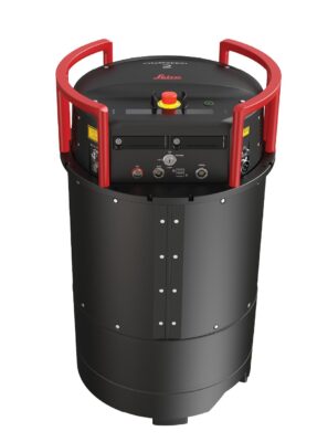
Leica CityMapper-2 hybrid airborne sensor.
Using the data captured with Leica Geosystems’ technology, Bluesky International could generate highly detailed orthophotos, point clouds, 3D building models, and meshes with <5 cm resolution, all from a single flight. This contributed to reduce the total flying costs and carbon emissions while creating data adaptable for a wide range of applications.
“In one flight we can capture all the required data,” says Ralph Coleman, Chief Commercial Officer at Bluesky International. “This makes us cost-effective for our customers while also helping us meet our ambition to achieve carbon neutrality.”
Furthermore, all these benefits come without customers having to sacrifice on quality. “On the contrary,” says Coleman, “we can deliver datasets that meet our customers’ demands on both accuracy and quality.”
A total of 7.5 TB of data was captured, including 13,885 images. This level of data gives Nottingham’s digital twin unparalleled accuracy and depth, so city managers can shape their urban landscape with the utmost precision.
From 2D to 3D
The shift to 3D geospatial data makes urban planning more efficient and highlights new opportunities. It enables more detailed insight into digital simulations of urban scenarios, from transport improvements to new construction.
Bluesky International seamlessly processed both imagery and lidar data within the same environment using the high-performance processing workflow software HxMap2, which supports Leica Geosystems’ airborne sensors. This allows for the generation of highly consistent data products crucial for creating Nottingham’s digital twin.
Increased transparency
A key goal for Nottingham City Council was to ensure access to digital-twin data across all the departments. The transition from 2D to 3D data has unlocked a new dimension of clarity and insight: by integrating the 3D mesh, the council could offer unparalleled visual fidelity and depth.
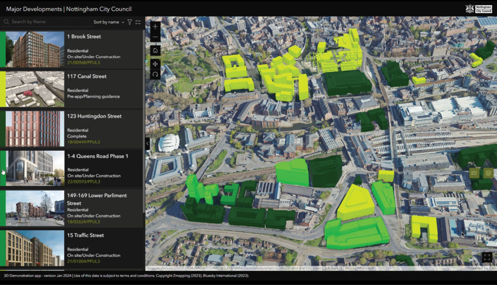
Nottingham’s digital twin makes decision-making processes more transparent, optimising urban planning for more sustainable city growth and innovation
The digital twin now means planners can share their proposed developments by dropping 3D building models into the digital twin. Each can then be linked to relevant documents within the digital twin, for example, planning permissions and proposals. Planners can then carry out site and morphology assessments of any new development using tools like line of sight, shadow assessment, and measurement embedded in the digital twin. This way they can more quickly assess the potential impact any new development will have on the surrounding area.
For Nottingham’s urban planners, 3D models are now established as a fundamental part of their assessment of major applications. With the digital twin, they can undertake constraints checks, accessibility analysis, and better understand the available infrastructure and amenities nearby. This way, the digital twin has increased the speed of decision-making and boosted confidence that developments will suit the environment.
Besides streamlining and enhancing the planning process, the creation of an easy-to-access digital twin helps foster public engagement, transparency, and more efficient public spending. “Ultimately, the beneficiaries of this data are the citizens,” says Coleman.
Future applications
The Nottingham City Council team is now working on combining aerial data captured with the Leica CityMapper-2 with data captured from mobile mapping technologies. This means new developments will be presented in an immersive real-world environment, increasing the scope of possible use cases for the data.
For critical infrastructure, planning can all take place within this immersive environment. Everything is streamlined, from highway scheme planning, asset capture, and network assessments to planning public safety measures, such as flood risk assessments or identifying the best CCTV placement positions on buildings. Similarly, this environment will enable more sustainable city development, including the effective planning of green spaces and examining potential areas to install renewable energy facilities, such as solar panels.
A more immersive, photorealistic digital twin is also more accessible to people not used to interpreting 3D models, such as planning committees and the public. This enables the council to share development plans more widely with residents in a format which is easier to understand.
As Laura Pullen, GIS Business Development Manager at Nottingham City Council, explains: “We hope to build on the work to date and, as we move forward, start to create hybrid mesh models incorporating street level photo capture for applications with transport planning and biodiversity studies, for example.”
“Working with a digital twin at this scale is not without its challenges, though,” said Pullen. “New skills have to be identified to make the best use of the new technology and data becomes critical in terms of its quality and timeliness.”
Nottingham City Council is at the forefront of revolutionizing urban planning practices, setting a precedent for local authorities across the UK. The council’s ultimate aim is to establish a blueprint for other local UK authorities looking to develop their own urban digital twins. This is because 60% of UK planning authorities are using the same GIS technology as Nottingham City Council. Nottingham’s new digital twin, therefore, shows others how this technology can be deployed to reshape their own urban environments.
By embracing digital twin technology, the council is not only streamlining planning processes but also fostering greater transparency, engagement, and efficiency in shaping the future of its cityscape. 
 Adina Gillespie is Vice President of Strategic Initiatives at Hexagon’s Geosystems division. With over 15 years of experience in earth observation technology, she focuses on advancing the adoption of technology and data analytics in institutions. Her primary goal is to optimize the utilization of remote sensing technology in both the public and private sectors.
 Layton Hobbs is the Product Line Director for Airborne Solutions at Hexagon’s Geosystems division, where he and his team are responsible for topographic lidar, aerial camera systems, and related software solutions. Layton applies decades of lidar and imaging experience to the development of Leica Geosystems’ sensor roadmap, leads new product strategy, and works to build awareness and understanding in the industry.