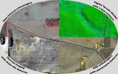
Remote sensing data of solar farm site. Clockwise starting with top left: Near Infrared orthoimagery, Digital Terrain Model (DTM) with 1’ topographic contours from gridded lidar, RGB natural color orthoimagery with planimetric features, subsurface drain tiles mapped over thermal imaging.
With the increasing societal interest in sustainable energy, solar power infrastructure continues to grow across the United States. Larger solar panel installations require extensive planning, from land acquisition through construction and energy harvesting. Remote sensing data can be exceptionally useful for the design, construction and maintenance tasks for large solar farms.
Surdex was recently contracted to provide imagery, lidar, planimetric and topographic contour data over a 20-square-mile future solar farm site. Planimetric data, which in this case consists of a complete inventory of all existing structures including powerlines and various other features, is useful for preparation of American Land Title Association (ALTA) / National Society of Professional Surveyors (NSPS) Land Title Surveys. These surveys are required prior to the acquisition of land and/or any solar farm construction. Topographic contour data generated by dense lidar assists in the design of the solar infrastructures and construction, such as with cut/fill calculations and slope analysis.
Not long after the initial flight, the client discovered from landowners the existence of a drain tile network. Agriculture fields often utilize an extensive subsurface network of drain tile to remove excess water from fields to aid in cultivation and harvesting of crops; however, the locations of tiles in this project were not accurately recorded during their installation. Conventional surveying methods was not the proper solution, so Surdex acquired thermal imaging to help locate underground tile locations. The acquisition was planned to take place following a heavy rainfall, as the analysis of the thermal images would indicate a contrast between the wet areas covering tiles and the adjacent dry areas. Thermal imaging from the medium infrared wavelengths (3-5 micron) can reveal the contrasting areas.
The use of remote sensing data to produce the surveying deliverables required for solar facility construction is cost effective and reduces man-hours in the field and office. This strategy results in an improved, more accurate final survey/design product in a shorter timeframe, which translates to more Americans tapping into renewable energy as soon as possible.
About the Author
Tim Bohn, CP, PMP, is a VP of Business Development at Surdex Corporation, focused on the Energy Sector. Tim has been with Surdex for 27 years and has a B.S. in Cartography and Mapping Technology from Missouri State University. For more information, contact Tim: timb@surdex.com (636) 368-4456.
