A revolutionary change of philosophy and architecture is required to take digital twins beyond visualization and fulfill their promise.
This article introduces a transformative concept of Smart Pixels as the building blocks of nextgeneration digital twins. I explore how Smart Pixels are poised to revolutionize design, analytics, and decisionmaking for built environments, signaling the emergence of a new era in geospatial technology. This forward-thinking article is intended for a wide audience within the geospatial mapping community, engineering, and software manufacturing, as well as industry leaders, technology strategists, and innovators. Although the article presents an innovative approach aimed at enhancing the performance and management of digital twins, the responsibility for optimizing hardware configurations and memory architecture ultimately rests with engineers and system architects. Their expertise will be crucial in translating these conceptual advances into practical, efficient implementations within real-world systems.
![]()
Rethinking the digital twin: why the future depends on the smart pixel
For years, the concept of digital twins has captivated professionals in planning, engineering, and operations, promising dynamic, interactive representations of real-world environments. The prevailing vision imagines digital twins as sophisticated platforms for simulation, optimization, and strategic insight. Yet, despite rapid advances in visualization and enthusiastic adoption across industries, most digital twins remain stuck in a paradigm of static, visually stunning 3D models. These representations may dazzle on screen, but their lack of integrated intelligence and rich, actionable data has limited their practical impact.
The challenge is not one of technological capability; it is a matter of architectural evolution. At the heart of true transformation is the Smart Pixel—a groundbreaking construct that reimagines each pixel in a digital twin as an intelligent micro-container. Within each Smart Pixel resides the “information DNA” of a location: its physical state, behavioral history, real-time measurements, and contextual metadata. This architectural shift turns digital twins from impressive visualizations into powerful analytic engines, enabling real-time decision support and predictive capabilities that were previously out of reach.
Beyond surface-level visualization: the intelligence gap
To unlock the full value of digital twins, systems must transcend mere visual fidelity. A genuine digital twin must:
- Process live updates
- Map precise measurements to specific locations
- Track dynamic changes over time
- Integrate data from multiple domains seamlessly
- Connect disparate information sources and support predictive models that forecast future conditions.
Current digital twins, however, often fall short. Most are built from photorealistic 3D renderings, fragmented GIS layers, isolated sensor feeds, and static lidar point clouds. Occasionally, they include tables of attributes that provide some context but little interactivity. These elements operate as silos, lacking a unified data structure or a mechanism to synchronize and update all information relevant to a single location. The result is a system that functions primarily as an advanced viewer, not as an intelligent, analytic platform.
Smart pixels: The foundational DNA of digital twin
The Smart Pixel introduces a paradigm shift. More than a simple graphical element or point in space, each Smart Pixel is a multidimensional container. It aggregates everything known about precise location, from geospatial attributes and sensor readings to behavioral trends and historical context. This comprehensive approach binds together previously fragmented data sources, enabling seamless updates, holistic analysis, and meaningful interactivity.
With Smart Pixels at the core, digital twins evolve into unified platforms that not only mirror the physical world but also understand and anticipate its changes. This new architecture empowers organizations to model scenarios, optimize operations, and drive innovation with unprecedented accuracy and agility. By embedding intelligence at the pixel level, digital twins become dynamic engines of transformation—poised to reshape industries and redefine what’s possible in the digital representation of our world.
The challenge: digital twins lack true intelligence
For a digital twin to deliver meaningful value, it must do far more than mirror the physical world with visual fidelity. The essence of a genuine digital twin lies in its ability to process real-time or near-real-time updates, incorporate precise physical measurements mapped to specific locations, and track dynamic changes over time. Additionally, it demands seamless integration across multiple domains—bridging data from disparate sources—and must enable predictive modeling to anticipate future scenarios.
Yet the reality for most digital twins today is starkly different. They typically consist of impressive, photorealistic 3D models, a patchwork of GIS layers that are only loosely connected, isolated streams from various sensors, and static lidar point clouds. Occasionally, these are supplemented by attribution tables that add some context but little interactivity.
While these elements may coexist within a single system, they function largely in silos. There is no unified data structure binding them together, and each component references the real world in its own way, disconnected from the others. There is no mechanism to store, update, or bring together the full spectrum of information about a specific location—be it a stretch of road, a building, or a shoreline—within a shared, consistent framework.
This fragmentation means that digital twins currently serve more as advanced viewers than as intelligent, analytical systems. Without true integration and interaction between their components, digital twins fall short of their transformative potential.
Comprehensive data DNA within each smart pixel
A Smart Pixel represents the foundational element of an advanced digital twin ecosystem. Unlike a simple pixel in an image or a lone point within a point cloud, a Smart Pixel (Figure 1) functions as a dynamic container of rich, multidimensional data, encapsulating every available detail about a specific spatial location. Each Smart Pixel contains its own data DNA, such as:
- Spatial attributes: Each Smart Pixel records precise three-dimensional geographic coordinates—including latitude, longitude, and elevation—along with the coordinate reference system and associated geometric uncertainty.
- Physical and environmental parameters: The Smart Pixel stores real-time measurements such as temperature, humidity, soil moisture, air quality indices, vegetation vitality, and water depth or turbidity, reflecting the environmental state of its location.
- Spectral and imaging information: Smart Pixels capture a spectrum of imaging data, from standard RGB values to multispectral and hyperspectral signatures, as well as thermal properties and reflectance characteristics, enabling detailed remote sensing analysis.
- Sensor metadata: Every Smart Pixel maintains metadata about the sensors and platforms that contributed its data—whether from UAS, satellites, or IoT devices—including the time of data acquisition, sensor geometry, calibration details, and lineage or accuracy metrics.
- Semantic attributes: It contains classifications—such as ground, building, vegetation, or roadway—alongside material type, condition, and risk assessments, adding meaningful context to each location.
- Temporal history: Smart Pixels record previous states, supporting trend analysis and change detection, and incorporate updates from predictive models to anticipate future scenarios.
- Connectivity to external models: Each Smart Pixel can link to external simulation models—including hydrodynamic, traffic, structural, or climate models—and respond to event triggers and rules that manage how updates propagate across the digital twin.
In summary, a Smart Pixel functions as a living, evolving data cell. It continuously aggregates and updates everything known about its spatial position, enabling the digital twin to operate with intelligence and analytical depth at the most granular level. This transformative capability allows digital twins to move beyond static representations, supporting real-time decision-making and predictive analytics for complex environments.
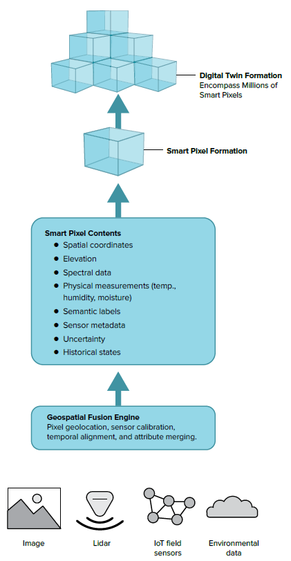
Figure 1: The role of Smart Pixels in a digital twin.
Why building digital twins on smart pixels is essential
- Digital twins must be analytical, not merely visual: Without Smart Pixels, digital twins are essentially 3D scenes with bolt-on analytics. With Smart Pixels, every location is an analytical object. Traditional digital twins that lack Smart Pixels are limited to being visually rich 3D representations with analytics layered on post hoc. In contrast, when constructed with Smart Pixels, every spatial location is transformed into an intelligent analytical entity. This means that analysis is embedded at the most granular level, making the digital twin inherently capable of advanced computations and insights rather than relying on external analytical modules.
- Facilitates real-time updates and advanced multi-sensor integration: Smart Pixels empower digital twins to assimilate data from a wide array of sources—satellites, drones, IoT sensors, and lidar—seamlessly and in real time. They enable automatic resolution of discrepancies among different sensor inputs and support time-sensitive data fusion, where new information can either update or enhance previous states. The result is a continually synchronized, accurate, and up-to-date digital representation of the environment.
- Enables robust predictive modeling: With each Smart Pixel encapsulating detailed physical properties, environmental conditions, and a historical timeline, sophisticated models—such as climate forecasting, flood risk simulations, structural health assessments, and traffic flow analyses—can operate directly at the pixel level. This pixel-centric intelligence allows for highly localized, precise, and actionable predictions that are grounded in rich contextual data.
- Unifies disparate data sources: Rather than maintaining multiple isolated layers of information, the Smart Pixel framework serves as a comprehensive and unified data backbone. All relevant attributes become indexed, searchable, and analyzable within a consistent structure, breaking down silos and streamlining data management across the digital twin ecosystem.
- Empowers artificial intelligence and autonomous systems: Artificial intelligence models achieve optimal performance when data is well-structured, metadata is standardized, uncertainties are quantified, and attributes are precisely localized. Smart Pixels provide this ideal data environment, enabling AI agents to detect anomalies, recognize complex patterns, conduct real-time simulations, and optimize operational strategies within digital twin environments.
- Smart pixels offer cloning and interoperability: Once a Smart Pixel has been created and populated with its rich set of attributes, it can be replicated and distributed to other digital twins managed by different organizations, agencies, or even across state lines. This cloning capability ensures that valuable, high-fidelity data does not need to be re-created from scratch, eliminating redundant efforts and maintaining a single, authoritative source of truth. By sharing cloned Smart Pixels, organizations can maximize the value of their information, streamline collaboration, and fully leverage existing resources, fostering more efficient and unified digital twin ecosystems.
- Smart pixels adapt to spatial scale: The spatial resolution of Smart Pixels within a digital twin is tailored to match the specific requirements and scale of the environment being modeled. This means that Smart Pixels can dynamically adjust in size—offering denser, higher-resolution coverage where detail is critical, and coarser, larger pixels where less granularity is needed. For instance, in the case of a digital twin representing an entire ocean, Smart Pixels near the coastlines would be much smaller and more detailed to capture the complex and rapidly changing conditions of these regions. As the digital twin expands into deeper ocean areas, where environmental changes are generally less pronounced and high-resolution data is less essential, the Smart Pixels become larger and less detailed. This strategic flexibility ensures that computational and storage resources are used efficiently, concentrating processing power where it matters most while maintaining comprehensive coverage across the entire modeled environment.
The smart pixel will transform the future of mapping
Digital twins anchored with Smart Pixels evolve far beyond traditional 3D objects or layered GIS datasets. Instead, they become dynamic engines for simulation, providing a foundation for real-time observation, advanced sensor integration, predictive analytics, and holistic system intelligence. The Smart Pixel framework empowers a digital twin to function as:
- A robust simulation engine that can replicate and analyze complex scenarios within the built or natural environment.
- An always-on monitoring system, continuously reflecting real-world changes as they happen.
- A seamless multi-sensor fusion platform, integrating data from satellites, drones, IoT devices, and more, in real time.
- An environment for predictive analytics, enabling localized, data-driven forecasts and actionable insights.
- A digital nervous system that interconnects and manages the flow of information across every spatial point.
This innovative architecture marks a critical shift for the industry, moving from:
- Simple 3D visualization to deep 3D understanding
- Basic data aggregation to true data intelligence
- Static mapping to dynamic, context-aware modeling
Ultimately, the Smart Pixel establishes itself as the essential backbone of intelligent digital twins—capable of encapsulating every facet of real-world information for any given location. This approach ensures that digital twins are not merely visual representations but comprehensive analytical platforms, supporting advanced computations, real-time operations, and informed decision-making at every scale.
Conclusion: Redefining the digital twin’s foundation
To realize the transformative potential of digital twins successfully, the geospatial industry must adopt the Smart Pixel as the foundational element of its next-generation platforms. The Smart Pixel is more than just a visual marker—it encapsulates the complete “DNA” of a location, including its geometric structure, physical characteristics, environmental variables, sensor data history, and semantic context.
The digital twins of tomorrow will be distinguished not by their ability to render 3D images, but by the depth and intelligence of their data architecture. By building upon the Smart Pixel, we shift from simple visualization to comprehensive data modeling, enabling digital twins to serve as dynamic, analytical engines that reflect and interpret every nuance of the real world.
Embracing the Smart Pixel marks a pivotal evolution. It transforms digital twins into powerful, context-aware platforms—capable of supporting real-time analysis, predictive modeling, and informed decision-making at any scale. This is the new backbone upon which the future of intelligent digital twins will be built.
Note: This article is running in Photogrammetric Engineering & Remote Sensing, LIDAR Magazine, and Geo Week Newsletter.