Applying lidar data with intent, validation, and judgment: Why the Level of Accuracy (LOA) framework and practitioner’s guide are changing how accuracy is applied in reality capture
The scan looked perfect (Figure 1). The point cloud was dense. Coverage appeared complete. Walls were crisp, geometry looked clean, and nothing raised concern during initial review. From a visual standpoint, the scan checked every box practitioners have come to associate with good data.


Figure 1: Partial facade scan of Union Station, Washington, DC.
Weeks later, problems surfaced. Dimensions did not reconcile. Elements that appeared aligned began to drift when referenced across larger extents. Modeling decisions became uncertain. Confidence eroded, not because the data was obviously flawed, but because its accuracy had never been clearly defined or validated against a known standard.
This scenario is more common than most are willing to admit.
In response to this persistent challenge, the U.S. Institute of Building Documentation (USIBD) developed the Level of Accuracy (LOA) Specification Guide v3.11 (Figure 2). The LOA provides a framework for defining how accurate information about existing conditions needs to be relative to its intended use. It replaces vague language with measurable expectations and gives project teams a shared understanding of what can be relied upon.

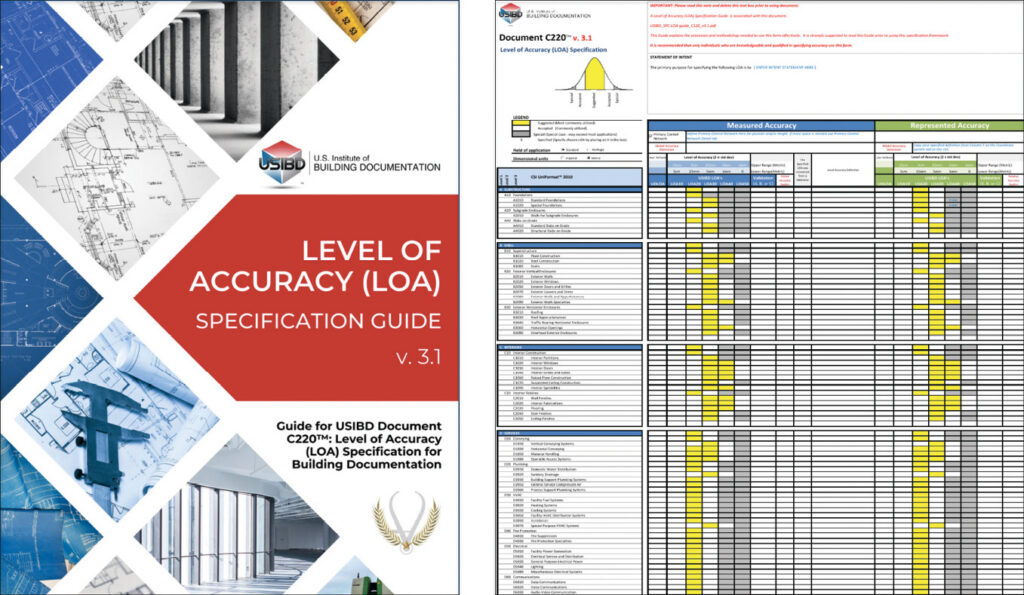
Figure 2: USIBD Level of Accuracy (LOA) Specification Guide v3.1.
The LOA does not prescribe how data is captured. It defines the outcome that must be achieved.
Yet, as widely adopted as the LOA has become, many practitioners still face a practical challenge. How is the LOA applied in real-world lidar workflows where constraints, judgment, and interpretation shape the final result?
That gap between specification and practice is what the LOA Practitioner’s Guide is designed to address.
The hidden risk in lidar workflows
Lidar has transformed how existing conditions are captured. Large and complex environments can now be documented quickly with remarkable detail. The resulting datasets appear authoritative, and in many cases, they are. But appearance can be misleading.
Terms such as “accurate”, “high resolution”, and “survey-grade” are often used without clear definition. One stakeholder may interpret “accurate” as suitable for fabrication, while another may understand it as sufficient for planning. Without a shared framework, both interpretations can exist at the same time.
Lidar workflows amplify this issue because the data looks convincing. Dense point clouds create visual confidence even when underlying geometry may be misaligned or weakly constrained.
The risk does not come from the data itself. It comes from how the data is interpreted and relied upon.
The LOA Specification addresses this by defining accuracy in measurable terms tied to intended use. It creates clarity where ambiguity has traditionally existed. However, understanding the specification alone is not enough. Applying it consistently requires a deeper level of interpretation and discipline.
Why precision misleads practitioners
One of the most common misunderstandings in lidar workflows is the confusion between precision, accuracy, and correctness (Figure 3).

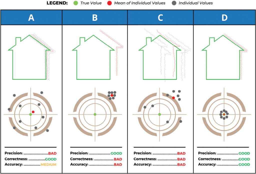
Figure 3: Precision, accuracy, correctness.
Precision refers to consistency. Lidar systems generate dense measurements that are highly repeatable. This creates datasets that appear stable and reliable.
Accuracy refers to how close those measurements are to real-world conditions. A dataset can be precise yet consistently offset due to registration error, weak control, or accumulated drift.
Correctness in the context of measured accuracy describes how well a result represents the true value. It evaluates the validity of the outcome, not the method used to obtain it. A measurement may be close to the true value, even coincidentally, yet still be unsuitable for the required LOA if the method cannot reliably achieve the required level of accuracy.
This distinction matters. A long corridor captured as a linear sequence of scans may appear seamless. Each scan aligns with the next, and the geometry looks correct. However, small registration adjustments accumulate with each connection. Over distance, these adjustments can result in measurable drift. The dataset looks right, but it has never been proven to be accurate.
Precision creates confidence. Validation creates trust.
The LOA helps resolve this confusion by anchoring accuracy to intended use and requiring that it be validated accordingly.
Intent defines process
Accuracy is not a default condition. It is a decision that begins with intent. What will the data be used for? Who will rely on it, and at what stage will they rely on it?
Too often, lidar data is captured for one purpose and later used for another. Data collected for visualization may be assumed to support design. Data captured for planning may be used for coordination. In these cases, the original intent is lost, and new expectations are followed without verification.
The data does not change, but the risk does.
Within the LOA framework, intent forms the basis for defining accuracy. It informs the selection of methods, the level of effort, and the validation approach. Without clearly defined intent, accuracy becomes subjective and difficult to defend.
When intent is defined early and preserved throughout the project, the resulting information is far more likely to be reliable and fit for purpose.
Field execution still matters, but it is not the whole story
Experienced practitioners understand the importance of sound field practices. Traversing, loop closure, control, and geometric strength remain fundamental regardless of technology. Lidar does not replace these principles. It depends on them.
Strong field execution, however, does not guarantee accuracy. It creates the conditions under which accuracy can be achieved.
A well-structured scan network can still fall short if the required level of accuracy was never defined. Conversely, data collected under constraints may still be suitable if its limitations are understood and aligned with its intended use.
The field is where accuracy is built.
Validation is where it is proven.
Validation: The most misunderstood step in lidar projects
Many accuracy issues do not originate in the field. They emerge during validation.
Validation is often treated as a final check. In practice, it should be defined at the beginning of the project as part of the overall accuracy strategy. Defining accuracy without defining how it will be validated introduces significant risk.
A common failure occurs when validation methods do not align with the level of accuracy being evaluated. For example, measuring across a room from one wall to another may seem like a reasonable check. In reality, this approach compounds deviations from multiple surfaces, each of which may fall within acceptable tolerance individually.
The result can suggest that the dataset is inaccurate, even when it meets the required criteria.
This type of mismatch can lead to unnecessary rework, disputes, and loss of confidence.
Most accuracy disputes are not caused by bad data.
They are caused by bad validation.
Validation must be intentional and appropriate to the required outcome. Comparing overlapping datasets can reveal internal consistency. Independent measurements can confirm alignment with real-world conditions. Each method has value, but only when applied correctly.
Figures 4 and 5 illustrate one example of validation through comparison of independent overlapping laser scan datasets. Two separately captured datasets are intentionally overlapped and compared against one another to evaluate consistency and reveal potential registration deviation. This type of comparison can help identify drift, alignment weakness, or accumulated error that may not be visually apparent within a single dataset alone.

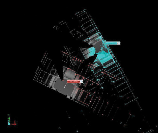
Figure 4: Two independent laser scan datasets.

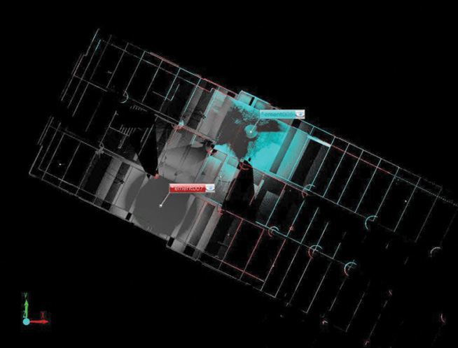
Figure 5: Overlapping laser scan data sets.
One of the most practical contributions of the LOA Practitioner’s Guide is how it connects validation concepts such as overlapping dataset comparison, independent verification, and fit-for-purpose evaluation to real-world workflows. It helps practitioners understand not only what methods exist, but when and why each should be used.
When validation is clearly defined and aligned with intent, it reinforces confidence. When it is improvised, it reintroduces ambiguity.
Measured and represented accuracy
Lidar workflows often extend into modeling and documentation. This introduces a critical distinction between measured accuracy and represented accuracy.
Measured accuracy describes how closely the captured data reflects real-world conditions. Represented accuracy describes how closely the model reflects the measured data. A model cannot be more accurate than the data it is based on.
This distinction is often overlooked. There is a tendency to assume that modeling can refine or improve accuracy. Modeling translates accuracy — it does not enhance it.
Understanding this relationship is essential for ensuring that downstream users interpret the information correctly.
Controlled abstraction: Where judgment defines quality
One of the most important aspects of working with lidar data is controlled abstraction. Not everything that is measured should be modeled exactly as it exists. Real-world conditions are inherently irregular. Walls are rarely perfectly flat. Floors vary subtly. Structural elements deviate in ways that may not matter for most applications. Modeling every variation introduces unnecessary complexity and reduces usability.
Controlled abstraction is the process of deciding what to simplify, what to preserve, and how to represent measured conditions in a way that supports the intended use. This is not about reducing accuracy. It is about applying it intelligently.
In practice, this becomes especially important for design workflows. Designers often prefer walls to be modeled orthogonally so they can dimension spaces clearly. When opposing walls are modeled as slightly non-parallel, reflecting true field conditions, it can complicate layout and coordination.
This is where abstraction becomes a deliberate decision. Rather than modeling walls exactly as measured, practitioners may apply best-fit methodologies to represent those walls as orthogonal. The variation is distributed evenly across the length of the wall so that the geometry remains usable while staying within acceptable tolerance.
The LOA provides the boundary for this decision. As long as the represented condition remains within the defined tolerance relative to the measured data, the abstraction is both valid and defensible.
Accuracy is not about modeling everything.
It is about modeling what matters correctly.
Over-modeling introduces noise. Under-modeling introduces risk. Controlled abstraction balances both. It is where technical capability becomes professional expertise.
Accuracy as a risk management tool
Accuracy is often viewed as a technical attribute. In practice, it is a form of risk management. Defining accuracy clearly allows project teams to understand what level of confidence they can place in the information. It reduces reliance on assumptions and aligns expectations across stakeholders. Without this clarity, risk is not eliminated. It is transferred downstream, where it appears as coordination issues, redesign, and disputes.
The goal is not to achieve the highest possible accuracy. It is to achieve the right accuracy for the intended use and ensure that it is understood by everyone involved.
Raising the standard for lidar practice
Lidar technology continues to advance rapidly. Faster capture, improved processing, and automation are expanding what is possible.
But technology alone does not define quality. As the industry becomes more reliant on measured reality, the consequences of misalignment between data and expectation become more significant. Decisions are increasingly based on digital representations of physical environments. The reliability of those decisions depends on how well accuracy is defined, achieved, and validated.
The LOA Specification provides the framework for doing this. It establishes a common language and a structure for aligning expectations. The LOA Practitioner’s Guide (Figure 6) builds on that foundation by bringing the framework into practice. It helps practitioners apply accuracy in real-world conditions where constraints and judgment play a central role. Accuracy is no longer just a technical attribute. It is a professional responsibility.


Figure 6: USIBD LOA Practitioner’s Guide.
Accessing the LOA framework and practitioner resources
Practitioners looking to strengthen how they define, apply, and validate accuracy in their work can access the full Level of Accuracy framework through USIBD2. A free copy of the LOA Specification is available for download at https://usibd.org/level-of-accuracy/.
For those seeking practical guidance on applying the LOA in real-world workflows, the LOA Practitioner’s Guide is available for purchase as an electronic download through the USIBD online store3. Additional resources, including LOA training and certification, are offered through the USIBD Education Center, providing a structured path for practitioners to build confidence, improve consistency, and apply accuracy in a way that is both defensible and fit for purpose.
- 1 Russo, J.M., 2025. USIBD: a new chapter for 2025, LIDAR Magazine, 15(1): 40-42, winter 2025.
- 2 https://usibd.org/level-of-accuracy/
- 3 https://www.bd-pros.com/usibd-loa-practitioners-guide