Topobathymetric lidar, a laser-based system that captures both land topography and shallow-water bathymetry, represents a significant leap in coastal mapping. When conditions are favourable, such airborne surveys can produce continuous models across the shoreline, reducing one of the most persistent headaches in coastal data collection: stitching together datasets from different sensors on land and at sea.
Topobathymetric lidar performance is highly dependent on water clarity, sea state, and environmental conditions, however, and often cannot penetrate sufficiently or provide reliable data. In such cases, one must fall back on traditional approaches, combining datasets acquired through different sensors — for example terrestrial lidar with marine sonar, each with their own coordinate reference systems and accuracy specifications.
Even when topobathymetric lidar works successfully at the coastline, it does not actually eliminate the integration problem; it simply shifts it elsewhere. Users may still need to integrate near-shore lidar with deeper water multibeam sonar surveys, offshore satellite altimetry, and terrestrial digital twins or national elevation models.
Fragmented data: Why it matters
Land and sea data may be acquired through specialised sensors, and measurement approaches tailored to particular domains and environments. Effective decision-making for coastal management is hindered by this fragmentation of land and sea data. When datasets are collected, stored and managed independently, the result may be inconsistencies, inefficiencies, and gaps in critical information. This lack of integration limits the ability to address cross-domain challenges such as infrastructure development, mitigating climate change, coastal erosion, and maritime security.
To enhance data-driven policymaking, there is a need for clear and practical advice on how to align or integrate land and sea data. At this time, this is not available in a clear, structured and concise manner. The United Nations Global Geodetic Centre of Excellence (UN-GGCE) in conjunction with TU Delft is trying to fix that.
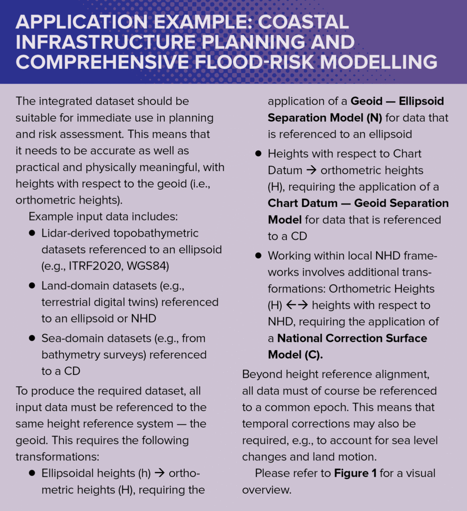
A classic example is flood-risk modelling. Land topography is often tied to a National Height Datum (NHD), typically established decades ago using tide-gauge observations of Mean Sea Level (MSL). Bathymetric surveys, by contrast, are usually referenced to a Chart Datum (CD), commonly Lowest Astronomical Tide (LAT). If these datasets are combined without proper vertical transformation, height mismatches can appear as artificial cliffs or trenches along the shoreline, distorting the resulting flood-risk models. While this example focuses on flood modeling, the same integration errors propagate across all cross-domain applications.
Institutional divides intensify the issue: national mapping agencies typically use NHDs or geoids; hydrographic offices prioritise safe navigation and therefore maintain LAT-based systems; environmental agencies may use several tidal datums depending on regulatory needs; and utilities or private contractors often introduce their own ad hoc local reference frames. Mismatches and inconsistencies between these can create safety risks, cost overruns, and poor resilience planning.
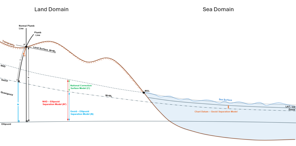
Figure 1: Illustration of 1) different height reference systems, how they relate and how heights are measured with respect to them, and 2) the models required for transformations between ellipsoidal heights, orthometric heights, NHD heights and CD heights.
For instance, if bathymetry is misaligned, dredging plans may overlook critical features, dredge too little, or operate inefficiently, which could lead to reworking or significant budget inflation. Misaligned data can also compromise navigation safety, increasing the risk of grounding, vessel damage, or even total loss. In the context of resilience planning, inaccurate elevation data will skew risk assessments (e.g. flooding or sea-level-rise adaptation), potentially underestimating vulnerability or overstating system stability, which in turn can lead to inadequate protective measures.
As noted earlier, topobathymetric lidar may help to some extent, but merely shifts the integration challenge rather than eliminating it.
Heights explained — a quick primer
In this process, it is important to understand the options, their technical meaning, and their relationships. A height reference system is a coordinate system used to define the height of a point above or below a reference surface. Each height reference system requires three fundamental components: a zero-point (datum point), a unit of measurement, and agreement on the type of height being used – the latter determining the path along which distances to the reference surface are measured. A height datum is the practical realization of such a height reference system through physical ties to the Earth’s surface.
Height determination requires care due to the number and type of datums or surfaces to which heights can be referenced, including:
- Ellipsoid: A smooth mathematical model of the Earth, used by GNSS (Global Navigation Satellite Systems) such as GPS. This is convenient and global, but has no physical meaning, i.e., for water flow.
- Geoid: An undulating surface representing equal gravity potential, approximating Mean Sea Level (MSL). Orthometric heights, i.e., heights with respect to the geoid, measured along the plumbline, are physically meaningful.
- Mean Sea Level (MSL): The average sea surface observed over a long period — often at a tide gauge. MSL is local, variable, and changes with climate.
- Lowest Astronomical Tide (LAT): The lowest tide that can be predicted under average meteorological conditions and any combination of astronomical conditions. LAT serves as the internationally recognised reference for Chart Datums (CDs) and water depths on nautical charts.
- National Height Datum (NHD): Each country’s official height reference system, typically established from tide-gauge observations of MSL at specific locations and periods. NHDs are not always consistent with the geoid or with neighbouring countries.
The relationships between these models are illustrated in Figure 1. Please note that this list is non-exhaustive and there are others, especially in the sea/tidal domain.
Practical pathways to integration
Integration with onboard GNSS systems ensures that lidar data is referenced to an ellipsoid. However, for practical applications — especially in coastal engineering or navigation, flood defense, and climate resilience work – heights must be referenced to a physical height datum such as the geoid, legacy datums such as NHD (if different from the geoid), or operational datums such as CD (i.e., LAT). Hence, transformations are unavoidable in these contexts.
To achieve these transformations and integrate land and sea datasets, one or a combination of the following models may be required:
- Geoid — Ellipsoid Separation Model (N): to transform ellipsoidal heights (e.g., from GNSS) directly into orthometric heights. Global models like EGM2008 offer coarse solutions, while regional or national geoids, established using a combination of dense gravity surveys, GNSS and levelling observations, provide much better solutions, achieving centimeter accuracy in data-rich areas.
- National Correction Surface Model (C): to transform orthometric heights into heights with respect to NHD. This is essential where NHD diverges from the geoid, and requires a network of co-located points where both GNSS and levelling observations are available. This model is commonly adopted to tie legacy systems to the geoid.
- National Height Datum — Ellipsoid Separation Model (N*): to transform ellipsoidal heights directly into heights with respect to NHD. While convenient, this approach is less accurate overall because it combines two models (i.e., N+C), and thereby also their respective uncertainties.
- Chart Datum — Geoid Separation Model: to transform heights with respect to the CD to orthometric heights. This model can be derived using comprehensive hydrodynamic models combined with satellite altimetry data and tide gauge observations. It is adopted to tie sea-domain datasets (e.g., bathymetric surveys) to the land.
Common pitfalls (and their consequences)
Even with access to appropriate transformation models, projects stumble on the same recurring implementation problems. Understanding and avoiding these pitfalls is crucial for successful integration.
- Datum confusion: The different versions of WGS84 (World Geodetic System), ITRF (International Terrestrial Reference Frame) and altimetry-specific ellipsoids like TOPEX are similar, yet slightly different. The differences, if not accounted for, can cause height offsets in the decimeter range, which can compromise flood-risk models, leading to inadequate coastal defences that could fail during extreme weather events.
- Timing and epochs: Absolute sea level changes with time and relative sea level is known to rise or fall owing to the impacts of land motion. Datasets from different years must therefore be adjusted to a common epoch using accurate geophysical models. Ignoring temporal changes can introduce significant errors.
- Positive up versus positive down: In the land domain, heights are typically recorded above a datum, whereas in the sea domain, “heights” (i.e., depths) are often recorded below one. Mixing them carelessly will generate false cliffs or trenches. These artificial features could cause dredging contractors to excavate non-existent shoals, wasting considerable money in unnecessary work, while missing actual navigation hazards.
- Poor metadata: Too many lidar products arrive without full documentation of their vertical reference. Guesswork is dangerous and can have far-reaching impacts.
The implications are straightforward: integration errors have financial and safety consequences. Investing in correct height reference management as part of the normal workflow is just as important as investing in hardware. Besides, the cost of the required geodetic expertise upfront is typically a small fraction of project value — far less than the cost of fixing integration errors later.
Institutions matter too
Even with the existing technical tools and approaches, institutional divides still persist. Hydrographic and mapping agencies maintain separate reference systems, and many national legacy systems were established decades to over a century ago, creating a patchwork of reference systems that can differ even within a single country.
Integration is therefore both a technical and an organizational challenge. Success requires building relationships across institutional boundaries and developing standards that respect each agency’s mission while enabling interoperability.
For lidar professionals, this means working closely with geodesists, hydrographers, and standards bodies, not just delivering point clouds. Early engagement with end users is essential, to understand their referencing requirements, and design data products that bridge institutional divides rather than perpetuate them.
The way forward
Here is what lidar professionals, managers, and academics need to keep in mind:
- Recognise that integration challenges remain, just that they may be shifted elsewhere.
- Adopt transformation workflows early — any lidar project must account for transformations into geoid-based systems, CDs, or NHDs, depending on the application.
- Plan for hybrid requirements — a single project may need data expressed with reference to multiple height datums (e.g., CD for navigation, geoid for flood risk).
- Coordinate actively — include geodetic expertise in lidar workflows. Don’t treat vertical referencing as an afterthought.
- Support data governance reforms — push for agencies to modernize geodetic infrastructure and publish relevant separation/correction models. This makes life easier for every downstream user.
Conclusion
Topobathymetric lidar may provide continuity across the shoreline, removing one of coastal mapping’s biggest challenges. Nevertheless, integration of different datasets, acquired by different sensors and referenced to different height datums, may still be required. The integration problem may have shifted, but certainly has not disappeared.
Successful data integration demands both technical understanding and institutional coordination. High-resolution data means little without trustworthy alignment into consistent, physically meaningful height reference systems. The consequences of poor integration — compromised flood-risk models, project cost overruns, safety failures, etc., underscore why geodetic expertise must be embedded in lidar workflows from project inception.
The path forward requires lidar professionals to incorporate necessary transformations early in their workflows, plan for multiple height datum requirements, and coordinate actively with geodesists and standards bodies.
While the shoreline may no longer be the primary obstacle, the fundamental challenge of integration remains as critical as ever. Addressing it successfully requires both technical excellence and international cooperation — which is precisely what the UN-GGCE’s implementation guidance aims to support.