Building on the outstanding response to Woolpert Chief Scientist Qassim Abdullah’s annual article on forecasting geospatial trends (on page 8 of this issue), we polled 31 experts across Woolpert to hear what they considered the top trends and topics to watch for in multiple markets across the architecture, engineering, and geospatial industry this year.
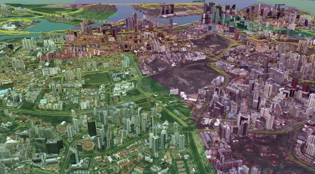
Woolpert conducted aerial lidar and imagery surveys in Singapore and produced derivatives including digital terrain models and photo-realistic 3D models, supporting the creation of a nationwide digital twin. These datasets are being used for urban planning with vector overlays including transportation networks and zoning boundaries.
In addition to the value these discussions provided individually, it was exciting to see several recurring themes emerge: the accelerating influence of AI, pressures on energy and water systems, rapid digital transformation, heightened global competition, and the continued integration of geospatial and sensor-driven data into decision-making.
This natural alignment highlights an increasingly interconnected world where infrastructure, technology, and environmental constraints converge.
Digital infrastructure, data centers, and AI-driven demands
Across multiple application areas, from data center decarbonization to energy and water supply, our experts emphasized the enormous pressures created by AI computation. Data centers are moving toward decarbonizing mechanical and electrical equipment, though the supply chain is still behind in providing credible carbon documentation. They also face intensifying public scrutiny and must improve collaboration with communities affected by rising power and water use.
AI is also dramatically reshaping asset management and monitoring practices. In structural and geotechnical monitoring, AI is enabling a shift from reactive to predictive, risk-based maintenance, raising questions about data quality, explainability, and integration into legacy management systems. Similarly, agentic geospatial AI will allow large language models to interact more naturally with geospatial models, increasing demand for accurate data and transparency.
Data centers also exemplify a broader concern: both power and water constraints are poised to become major limiting factors for growth in advanced technology industries. Experts note that water supplies, energy capacity, and aging infrastructure will be key bottlenecks unless significant investment and innovation occur.
Geospatial technologies, remote sensing, and digital twins
One of the strongest trends across industries is the explosion in remote sensing, high-resolution mapping, and adoption of digital twins, which are evolving into “living” models that incorporate real-time survey and sensor data, enabling more informed decision-making.
Global geospatial programs are expected to expand in economic impact, with new opportunities in sectors such as agriculture, water, and environmental monitoring. In the United States, once the 3D Elevation and Hydrography Programs (3DEP and 3DHP) are completed — using high-resolution data from airborne lidar and IfSAR sensors for the topographic part — it will produce an advanced 3D National Topography Model (3DNTM) that integrates elevation, hydrography, and bathymetry. This initiative represents an early step toward creating a comprehensive nationwide digital twin, promising many exciting future applications.
Precision from space is also expected to increase, with technologies like GNSS, IfSAR, IoT, and satellite communications integrating more seamlessly to deliver reliable ground movement data. In hydrographic and aerial survey sectors, unmanned surface vehicles, topobathymetric lidar, and semantic change intelligence are advancing rapidly, enabling automated compliance tracking and 4D environmental understanding.
Critical infrastructure: Water, energy, transportation, and airports
Water systems face several immediate challenges. Data center expansion is driving dramatically higher water demand, requiring updates to master plans and municipal criteria. With tightening water-quality regulations and improvements in monitoring capabilities, infrastructure will need shorter life cycles and more flexible design approaches. Regionalization of water providers is expected due to cost pressures and staffing shortages.
Energy systems will similarly be shaped by the intersection of AI, natural gas reliability, and global energy security. Demand for liquefied natural gas exports is projected to grow, and infrastructure resilience will become a major form of capital discipline as companies rely on spatial digital twins for real-time monitoring.
Transportation systems in the United States are influenced by both federal funding uncertainty and a rapid embrace of digital and autonomous technologies. State and local agencies must prepare for the continuation — or potential disruption — of grant programs established under the 2021 Infrastructure Investment and Jobs Act. Meanwhile, policymakers are advancing high-definition maps, IoT standards, and real-time monitoring systems to boost safety and predictive maintenance across roads, rails, and bridges.
Airports face a combination of electrification challenges and digital transformation. Peak power demands may double or triple without major grid upgrades. Airports will also increasingly serve as digital hubs, supporting network operations and data centers while integrating smart charging systems, eVTOL infrastructure, and advanced air mobility concepts.
Defense, military planning, and the Indo-Pacific region
U.S. military planning is undergoing significant shifts, with nearly $20 billion allocated in FY2026 for global construction, including hangars, command centers, and housing, as well as the location, extraction, and transportation of critical minerals. U.S. strategic interests in the Indo-Pacific region, Africa, and Europe will continue to leverage geospatial technology and remote sensing.
In the broader Indo-Pacific region, nations are pushing for greater digital and physical infrastructure ownership, increased data governance capacity, and expanded regional collaboration.
Global defense and intelligence agencies are leveraging digital twins, GIS, lidar, UAV-based surveys, and GeoAI for faster, more integrated design and planning and maintaining data sovereignty. AI agents will support intelligence gathering and analysis, creating more dynamic and proactive workflows.
Coastal resilience, climate adaptation, and natural infrastructure
Coastal resilience programs are benefiting from massive data availability, enabling the use of machine learning and analytics for better project decisions. Nature-based infrastructure solutions are becoming more popular as understanding grows around the natural processes shaping water resources. Policy changes are likely under shifting federal leadership, creating demand for innovative, adaptive approaches.
Workplace culture and AI — a new standard for inclusivity
Finally, workplace culture in 2026 is expected to be transformed by AI-driven work design, ethical governance, and human-centered hybrid work models. Organizations must focus on psychological safety, values alignment, and creating meaningful, inclusive environments to avoid burnout and polarization.
This increasing alignment across industries is an opportunity to focus, collaborate, and drive innovation in a way that will benefit people around the world. I am looking forward to what we can accomplish together in 2026.
 Amar Nayegandhi, CP, CMS, GISP is global head of technology and innovation and geospatial sector leader at Woolpert. He is responsible for aligning, optimizing, integrating, and expanding Woolpert’s technology portfolio across its globally integrated architecture, engineering, and geospatial platform. Amar is an ASPRS Fellow and was the director of the ASPRS Lidar Division. He co-edited ASPRS’s The DEM Users Manual, 3rd Edition and authored the chapters on airborne topographic lidar and airborne lidar bathymetry.