Denver, Colorado, 20 February 2025 – Shallow coastal zones are where most ship groundings occur, and they are also where the most inaccurate and outdated information on official nautical charts resides. TCarta, a provider of hydrospatial mapping services, has introduced a new line of Satellite Reconnaissance Charts to supplement official marine navigation maps in shallow waters.
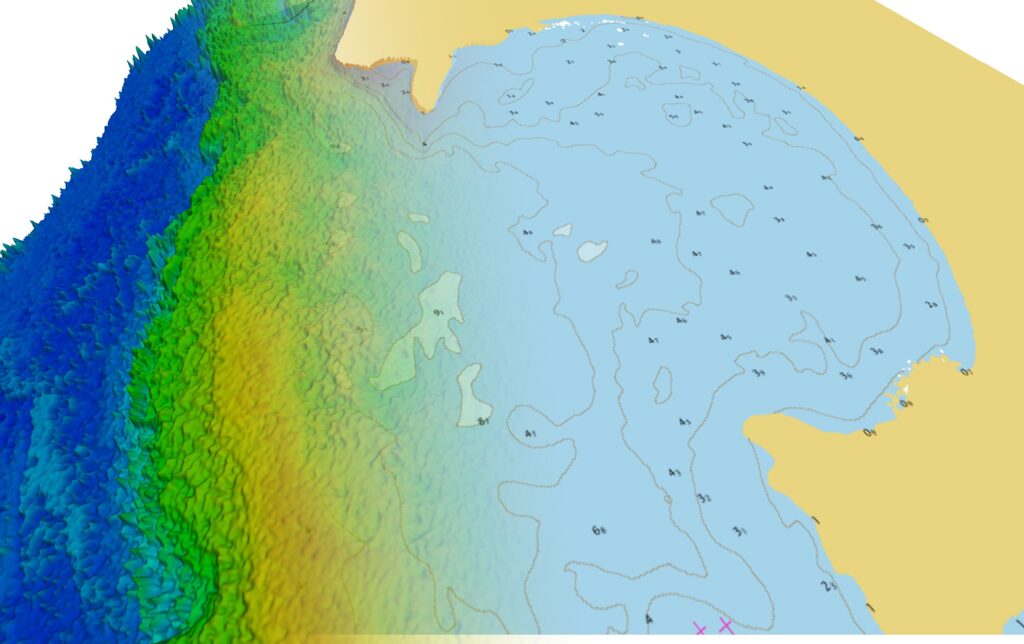
3D view of Negril, Jamaica, showing 1:4,000 scale TCarta Satellite Reconnaissance Chart with 3m resolution Satellite Derived Bathymetry.
TCarta will introduce the new Satellite Reconnaissance Chart products to the hydrographic community on Tuesday, February 25, at the 2025 Esri Federal GIS Conference in Washington, D.C.
Derived from recently acquired satellite imagery, TCarta Satellite Reconnaissance Charts are digital maps adhering to International Hydrographic Organization S-57 and S-100 data model standards with the same appearance and symbology as official navigation aids. However, the TCarta Charts do not replace official nautical map products, which are primarily designed for marine navigation in commercial shipping lanes.
The new TCarta Satellite Reconnaissance Charts contain up-to-date details of seafloor depths, sandbars, reefs, shoals, and other submerged hazards – along with floating dangers – in the near-shore environments that are often poorly mapped or out of date on official maritime charts. Offered at off-the-shelf 1:20,000 scale and custom 1:4,000 scale, the TCarta products are delivered in file formats ready to load into popular marine navigation software as well as common GIS software platforms.
“We launched the Satellite Reconnaissance Charts to enhance the awareness and safety of vessels operating in shallow waters, such as recreational boats, private yachts, fishing vessels, and military ships,” said TCarta President Kyle Goodrich.
Another major user of these products, however, will be government hydrographic offices, explained Goodrich. The TCarta Charts will serve as accurate and timely guides for those organizations to plan hydrographic surveys to update official nautical charts, especially in dynamic coastal zones, enabling their operations to be more efficient and avoid hazardous situations.
“Collection of high-quality water depth measurements in shallow coastal areas is expensive and dangerous to acquire by ship or aircraft, notably in remote or contested regions,” Goodrich said. “Our Satellite Reconnaissance Charts will help reduce risk, time and costs in coastal hydrographic surveying.”
The Satellite Derived Bathymetry (SDB) technology refined by TCarta and used to create the new Reconnaissance Charts is uniquely suited to measure water depth accurately and inexpensively while posing no danger to personnel, equipment, or coastal ecosystems. SDB applies physics-based computer algorithms to optical imagery captured by commercial remote sensing satellites. This analysis detects and measures light reflecting off the seafloor to calculate water depth. Depending on water clarity, SDB is accurate to depths of 20 to 30 meters.
TCarta has mapped nearly one third of the world’s coastlines with SDB and offers products in custom and off-the-shelf versions. Custom SDB data sets are typically generated using high-resolution satellite imagery capable of resolving seafloor objects, such as shoals and reefs, with one-meter resolution. Satellite Reconnaissance Charts can be created for nearly any shallow-water area in the world and are available off the shelf now in the following regions:
- Caribbean
- Arabian/Persian Gulf
- Red Sea
- Many Pacific Islands
- Florida and Mexican Coasts
Satellite Reconnaissance Charts are available for specific locations, regions, and entire countries. Commercial organizations may order bathymetry products directly from TCarta and the US government can purchase through the GSA Schedule.
About TCarta
With offices in the United States, Jamaica, and Canada, TCarta has built an international business on cost-effectively and safely deriving onshore and offshore data sets using multispectral imagery captured by Earth observation satellites – without negative impact on the natural habitat. TCarta products and services are relied upon by governmental, insurance, oil & gas, environmental, and infrastructure development clients in applications as diverse as natural resource monitoring, tsunami modeling, disaster & hazard response, and hydrologic studies. The TCarta product lines include high-resolution satellite-derived water depth and seafloor map products as well as 90- and 30-meter GIS-ready bathymetric data aggregated from numerous information sources. TCarta has also recently unveiled the use of ICESat-2 LiDAR data sets for use in SDB validation, and the TCarta Global Satellite Derived Bathymetry (G-SDB) off-the-shelf products. G-SDB is generated with Machine Learning and ICESat-2 laser data at 10m resolution to depths of 30m depending on water clarity. www.tcarta.com
