Horn, February 2025 – As one of the leading providers of UAV-based laser scanning solutions, RIEGL will, of course be present at the first XPONENTIAL Europe from February 18 to 20, 2025 in Düsseldorf! In hall 01 at stand 1B01, RIEGL will provide an insight into the latest developments in LiDAR technology and present its broad portfolio of UAV-LiDAR sensors for a wide range of surveying applications.

When top performance is required: RIEGL VUX-120-23 with NFB Scanning
Is your field of activity diverse, your tasks challenging, and your customers expecting first-class data every time? Then the proven RIEGL VUX-120-23 is the UAV LiDAR sensor of your choice! This compact and lightweight scanner provides up to 2.4 MHz PRR (Pulse Repetition Rate), up to 400 scan lines, and effectively 2 million measurements per second on the ground. NFB (Nadir/Forward/Backward) scanning – an innovative scan pattern for optimum detection of vertical targets – combined with a field of view of 100° provides first-class data, especially when mapping power line routes. Thanks to the wide field of view, the drone can fly parallel to the asset and not directly above the target, which significantly increases safety. With its technical specifications, the scanner also presents itself as the ultimate solution for use on fixed-wing UAVs in the field of corridor mapping.
When space is limited: The RIEGL VUX-100-25 for data acquisition in urban street canyons
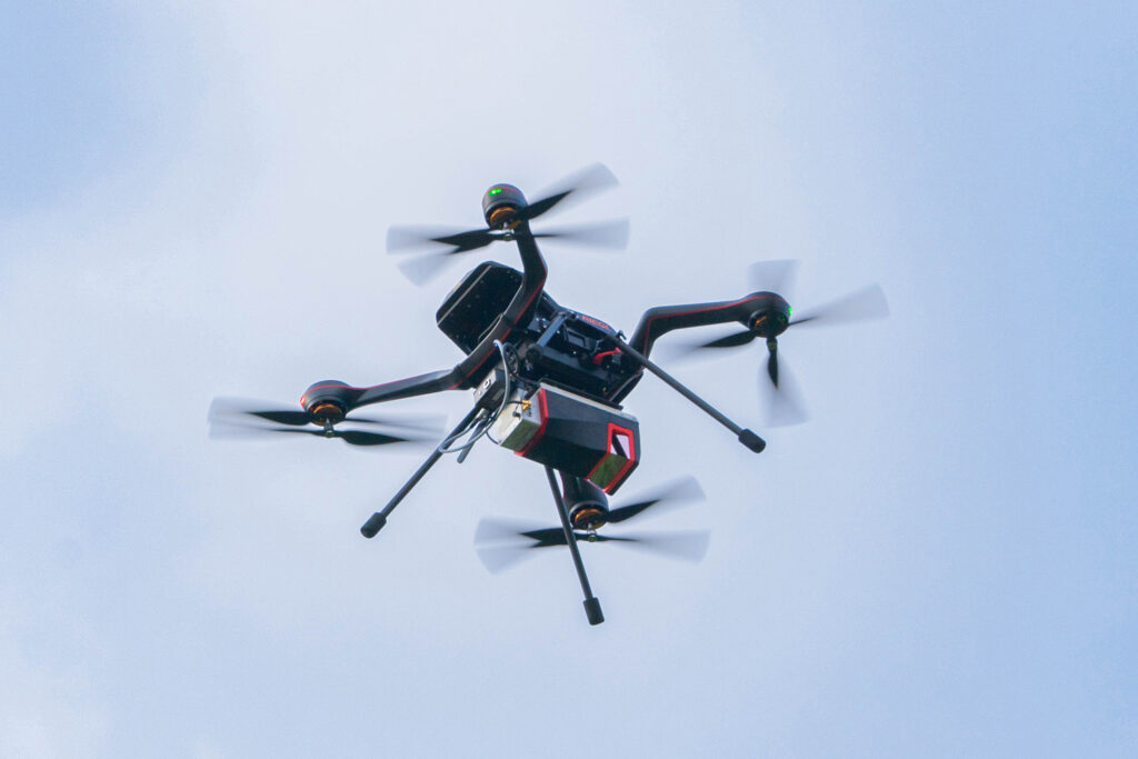
RIEGL miniVUX-3UAV LiDAR Sensor with RiLOC-E
With the new VUX-100-25, RIEGL completes its VUX series of high-performance sensors for UAV-based surveying. The lightweight (2.36 kg / 5.2 lbs) and versatile scanner with a field of view of up to 160 degrees offers excellent performance data: up to 1,500 kHz pulse repetition rate, up to 1.3 million measurements, and up to 200 lines scan speed per second, as well as a flight altitude of up to 360 m / 1,200 feet. This enables particularly large area coverage – ideal for applications such as mapping complex terrain and narrow ravines, especially road courses in densely built-up urban areas. The sensor can easily be used on a wide variety of drones, as well as on small manned aircraft (such as gyroplanes) and manned helicopters.
When speed and simplicity are essential, but accuracy is crucial: RIEGL RiLOC System Solutions
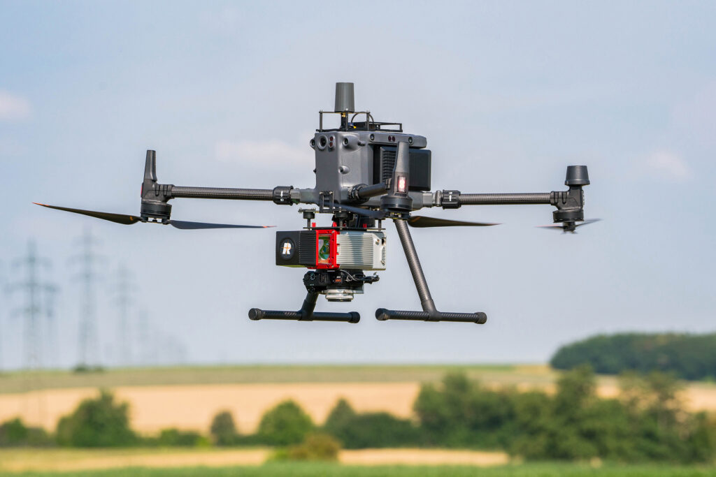
RIEGL VUX-100-25 UAV LiDAR Sensor with RiLOC-F
With the new RiLOC system solutions from RIEGL – two different models are currently available, the RiLOC-E-25 and the RiLOC-F – you not only have a laser scanner for UAV-based data acquisition that provides survey-grade measurement data: You have a high-level overall system with a high-quality IMU/GNSS unit and software for simple and efficient data evaluation at your disposal. You can capture, process, generate point clouds, and geo-reference data – all at record speed. Simplified workflows both in the field and in data processing save time and money. System parameters and scan settings can be defined before the flight, and the system can be operated completely autonomously during data acquisition. The pilot can concentrate fully on the safe execution of the flight. User-friendly integration into a wide variety of platforms helps to keep the range of applications broad, while performance, reliability, and durability ensure an optimum cost/benefit ratio. This enables both newcomers and lateral entrants, as well as established surveying service providers, to open up new markets.
When you need that extra edge: RIEGL‘s Commitment to Quality
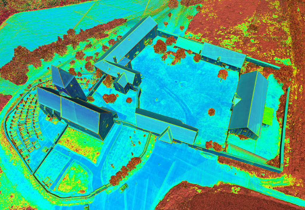
RIEGL VUX-10-25 point cloud data “reflectance scaled”
The RIEGL team will explain the general advantages of drone-based data acquisition using a wide range of practical application examples. Together with you, they will develop optimized solutions for your applications – supported by a broad portfolio of sensors and sophisticated software packages for data processing. Erwin Burth, Managing Director of RIEGL Germany, says: “You name your requirements, existing structures, and your personal scope – and we will put together an optimized system for a highly efficient workflow for you.”
The RIEGL team is looking forward to your visit at the RIEGL booth 1B01 at XPONENTIAL 2025 in Düsseldorf. Details of RIEGL’s trade fair appearance can be found here, you are welcome to make an appointment in advance at info@riegl-de.com!
About RIEGL
RIEGL is an international leading provider of cutting-edge technology in airborne, mobile, terrestrial, industrial and UAV-based laser scanning solutions for applications in surveying. RIEGL has been producing LiDAR systems commercially for over 40 years and focuses on pulsed time-of-flight laser radar technology in multiple wavelengths. RIEGL’s core smart-waveform technologies provide pure digital LiDAR signal processing, unique methodologies for resolving range ambiguities, multiple targets per laser shots, optimum distribution of measurements, calibrated amplitudes and reflectance estimates, as well as the seamless integration and calibration of systems. RIEGL has always been committed to delivering the highest performance, quality, reliability, and longevity of all its products and services, and strict adherence to applicable international standards is a priority. Worldwide sales, training, support and services are delivered from RIEGL’s headquarters in Austria and in the USA; main offices in Japan, China, Hong Kong, Australia, Canada, UK, Germany, and Chile; and a worldwide network of representatives. In the field of UAV-based measurement data acquisition, RIEGL offers a range of LiDAR sensors and systems for a wide variety of tasks. This broad portfolio, which is distributed by RiCOPTER UAV GmbH, a company of the RIEGL Group, makes it possible for individual customers to find exactly the right sensor for their specific surveying task. More info: www.riegl.com
