Lidar and 3D technology deliver benefits to discovery, restoration and preservation
From preserving the fine details of historical landmarks to uncovering the genius and resourcefulness of ancient civilizations, lidar and 3D rendering technology offer an incredible opportunity to understand humanity’s past and present. With geospatial tools and multi-industry collaboration the past can be revealed and the future shaped with more beneficial insights. Recent newsworthy restoration projects such as the Notre-Dame Cathedral, as well as examples from Alcatraz, the Maya, and beyond, show how these cutting-edge technologies provide a fuller picture of the past and help stabilize and modernize for centuries to come.
Alcatraz Island
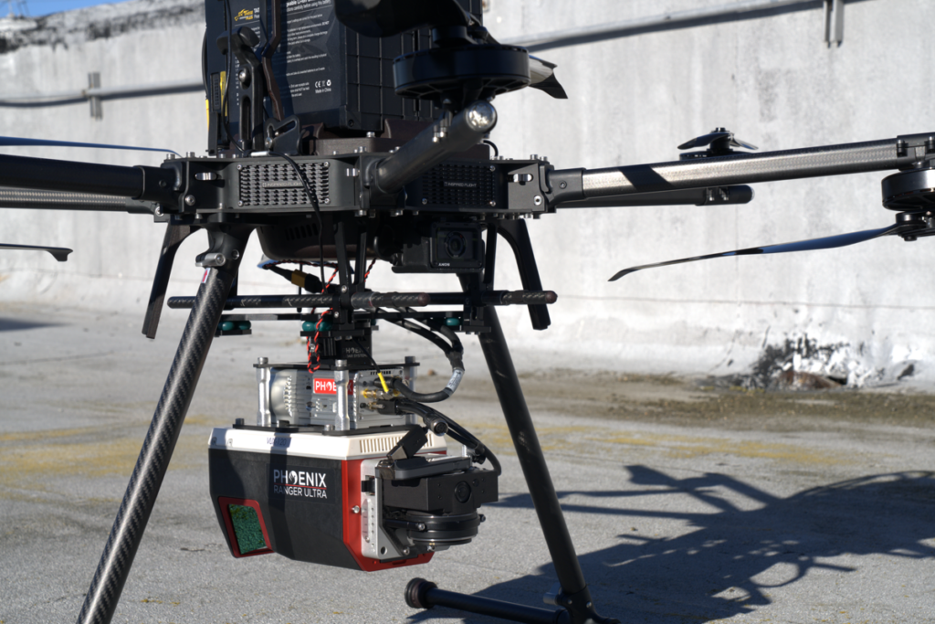
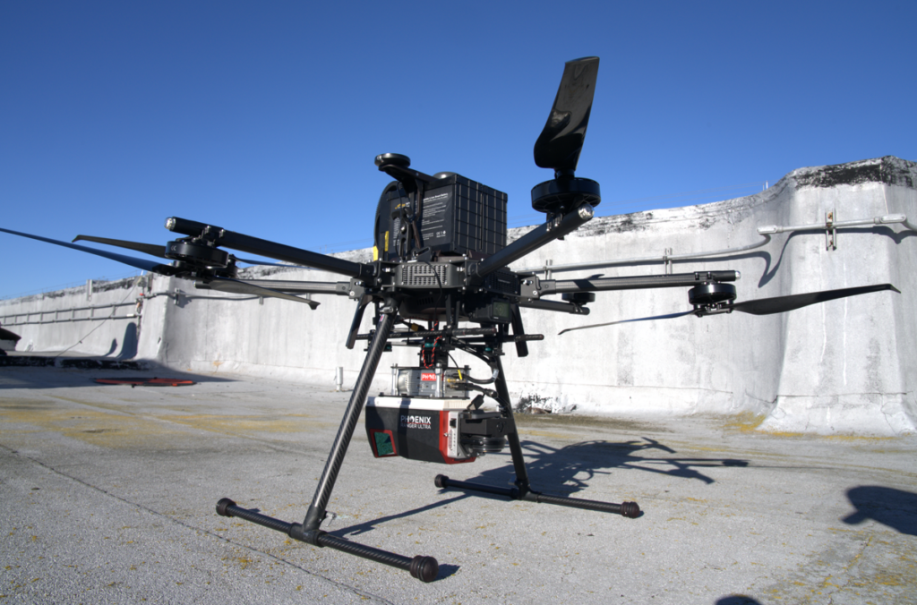
The Alcatraz lidar project in California combined both UAV-lidar and terrestrial laser scanning to capture the entire island, from its rugged coastline to its deteriorating structures, which had served as a maximum security federal penitentiary, military prison, and fort. Using the Phoenix RANGER-U120 system, data was collected to produce high-density point clouds of smaller scan areas, capturing details as fine as hairline cracks in the prison cellhouse walls. The resulting dataset provided engineers and preservationists with unprecedented accuracy to assess structural vulnerabilities and prioritize restoration efforts.
The analysis of foundation shifts caused by coastal erosion provided a critical insight. The scan revealed micro-distortions that were invisible to the naked eye but essential to understanding long-term stability risks. By combining these scans with environmental monitoring data, engineers developed a predictive model to plan for proactive interventions.
Beyond its technical contributions, the Alcatraz project serves a public purpose. The high-resolution 3D data has been incorporated into virtual tours, providing visitors with unparalleled access to areas of the island that are typically off limits. In doing so, lidar has ensured that the story of Alcatraz can be experienced and appreciated by audiences worldwide, preserving not just its physical form but its cultural significance.
Maya Lowlands
While the Alcatraz project demonstrated lidar’s value in preservation, its application in Chiapas, Mexico, showed its potential for discovery. The dense jungles of the Maya Lowlands had long concealed evidence of ancient civilizations, but other UAV-mounted sensors from Phoenix LiDAR Systems transformed the landscape into a detailed map of archaeological features.
One of the most striking findings came from Nuevo Canán, where lidar data uncovered an intricate system of channelized fields and terraces. These features revealed how the Maya adapted to their challenging environment, providing new insights into their agricultural and urban planning practices. Similarly, at Paso del Tigre in Oaxaca, the team identified a 35-meter-long dam and water reservoirs, underscoring the sophistication of Mayan systems for water management.
Processing the data was as critical as collecting it. Ground-classification algorithms filtered out dense vegetation, isolating terrain data and enabling us to detect subtle features like low mounds and terraces. Digital elevation models (DEMs) were enhanced using slope analysis and multi-directional hillshading to visualize anthropogenic modifications. The iterative process of refining the data—balancing automation with manual corrections—ensured that we could confidently distinguish archaeological features from natural topography.
The discoveries in Chiapas not only enhanced our knowledge about the Mayan civilization but also highlighted the potential for lidar to reveal lost histories in other regions of the world.
Lidar’s true power lies in its ability to connect the past with the future. In Chiapas, the insights gained from ancient Mayan agricultural techniques could inspire modern approaches to sustainable land use and water management. At Alcatraz, lidar’s millimeter-level accuracy has ensured that preservation efforts are guided by data-driven decisions, setting a standard for maintaining historical landmarks in the face of environmental challenges.
Notre-Dame Cathedral
A similar story unfolded with the Notre-Dame Cathedral in Paris. Lidar scans from before the catastrophic fire in April 2019 provided the blueprint for its restoration, enabling teams to recreate its intricate Gothic architecture features while addressing structural vulnerabilities. These examples illustrate how lidar doesn’t just document history—it informs the strategies needed to ensure that history endures.
Methodologies and collaboration matter
The success of these lidar and modeling technology projects rests on the precision and adaptability of the methodologies used. At Alcatraz, integrating aerial and terrestrial lidar systems allowed the team to capture the island’s varied terrain and structures in exceptional detail. Processing the point clouds involved multiple layers of filtering to eliminate noise and refine the data.
For archaeological projects such as those in Chiapas, additional challenges arose. Dense vegetation and steep terrain required aggressive ground-classification techniques, using advanced software such as LAStools and ArcGIS Pro. Features like defensive walls and reservoirs were made visible through multi-resolution filtering and derivative visualizations such as slope maps and aspect models. This combination of tools and techniques ensured that even subtle features were accurately captured and interpreted.
Lidar’s effectiveness depends not only on the technology itself but on the collaboration it fosters. At Alcatraz, the project brought together engineers, conservationists, and historians, each contributing their expertise to interpret the data and implement solutions. In Chiapas, local communities played a vital role in contextualizing the findings, adding cultural depth to the technical data.
This collaborative spirit extends to public engagement. By transforming lidar data into interactive 3D models and virtual experiences, these projects have reached beyond academic and professional circles, inspiring broader awareness and appreciation of cultural heritage.
Lidar has proven itself to be more than just a tool for discovery. It is a means of storytelling, a way to bridge the gap between the worlds we’ve inherited and the futures we hope to create. From preserving the architectural details of Alcatraz to uncovering the agricultural ingenuity of the Maya, lidar technology offers a lens through which we can better understand humanity’s journey.
As the application of lidar continues to expand, so do the possibilities. Whether stabilizing a crumbling landmark or revealing an ancient civilization’s resilience, lidar reminds us that every structure, every landscape, and every artifact carries a story. It is up to us to ensure that those stories endure—not just in archives, but in the physical and virtual spaces we share with the world.
 Walter Lappert is a seasoned engineering leader and innovator with extensive expertise in lidar, sonar, radar, GNSS, and photogrammetry technologies. Over his career, he has developed and deployed advanced remote sensing platforms for aerial, terrestrial, and hydrographic data collection, contributing to groundbreaking projects in reality capture, digital twins, and 3D modeling. Currently serving as the Director of Reality Capture at Allen3D, Walter leads cutting-edge initiatives, develops systems, and spearheads innovative applications that harness lidar and 3D rendering technologies to uncover ancient civilizations, modernize historical preservation efforts, and pioneer advances in urban planning. In addition to his technical contributions, Walter has a strong background in standards development and education, having influenced the standards of the Federal Aviation Administration and the American Society for Testing and Materials for small, unmanned aircraft systems and designed a drone program curriculum for universities. His ability to bridge technology with strategic vision makes him a key figure in leveraging geospatial tools to illuminate the past and shape the future.