Arkansas teams with Woolpert on ambitious lidar acquisition plan
The 3D Elevation Program (3DEP) conducted by the U.S. Geological Survey (USGS) has bolstered Arkansas’s economic growth and provided its taxpayers with myriad returns on investment. Led by the state’s Geographic Information Office (GIO), Arkansas has leveraged baseline 3DEP digital elevation data to reduce costly agricultural water usage, mitigate flood risks, identify dangerous geohazards, and accelerate infrastructure development activities. As a result, Arkansas residents are safer, their farms are more sustainable, and the overall business climate has grown more attractive.
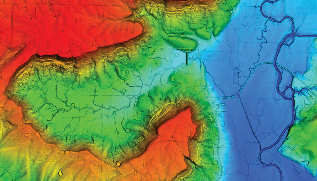
Bluff and river in eastern hills of Arkansas. Image courtesy of United States Geological Survey.
When 3DEP launched its next-generation refresh phase, Arkansas jumped at the opportunity in 2023 to obtain new elevation data to augment the baseline products acquired during the previous eight years. Concurrently, the state saw significant value in increasing its funding share to acquire lidar elevation points at a higher density—8 points per square meter (ppsm) versus 2 ppsm in the baseline collection.
The increased point density of the next generation 3DEP data will result in greater accuracy in projects using that data, while driving an overall positive economic impact for Arkansas, according to the state’s GIO. Nationwide, this repeat coverage of higher-quality lidar will support the detection of landscape changes due to construction, urban growth, landslides, lava flows, surface mining, shoreline erosion, and many other natural and anthropogenic impacts.
Refreshing the baseline 3DEP data
USGS began its first full year of 3DEP production in 2016 with the goal of capturing high-resolution topographic elevation measurements for use in generating baseline datasets of bare earth digital elevation models (DEMs) and 3D point clouds for the nation [see sidebar].
From the outset, a unique aspect of 3DEP has been its shared program funding and coordination among federal, state, tribal, and local government agencies. More than a dozen aerial mapping firms were contracted to perform the acquisitions, using airborne lidar everywhere except for Alaska, where cloud cover necessitated the use of synthetic aperture radar. Baseline lidar specifications called for the capture of Quality Level 2 (QL2) elevation measurements at 10 centimeters vertical accuracy and 2 ppsm density. To date, 98% of the nation has been mapped successfully in the 3DEP baseline phase.


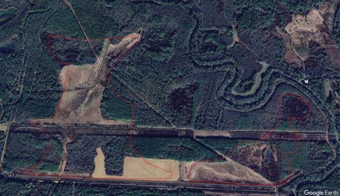
These comparisons for Google Airbus 2024 data (top) and 2024 3DEP (bottom) shows how the 3DEP data is used to help manage rice field flooding. The polygons in the data show the interpolation. 3DEP images courtesy of United States Geological Survey.
In 2023, USGS made several modifications to 3DEP, most notably the option for states to “buy up” to QL1 data collection at 8 ppsm, i.e. to help fund the upgrade when otherwise the collection would have been at the QL2 level. Thanks to technological advances in airborne lidar systems that have reduced operating costs since 2016, QL1 data has become more affordable for many states.
USGS selected Woolpert, an international architecture, engineering, and geospatial firm with a long history of supporting large-area mapping activities, including 3DEP, to collect new data across Arkansas. The state and the company collaborated to generate an ambitious 3DEP refresh plan to map the entire state in just two flying seasons, the 2023/24 and 2024/25 seasons, to support data consistency.
Mapping Eastern Arkansas
The new acquisition plan divided the state roughly into eastern and western halves, each to be captured during a leaf-off period from early December to late March. To cover this large area, Woolpert dispatched three of its 13 aircraft to the state, each equipped with powerful Leica TerrainMapper lidar scanners. Flying at 6500 feet above ground level, these sensors collected elevation points as well as four-band imagery used for feature validation.
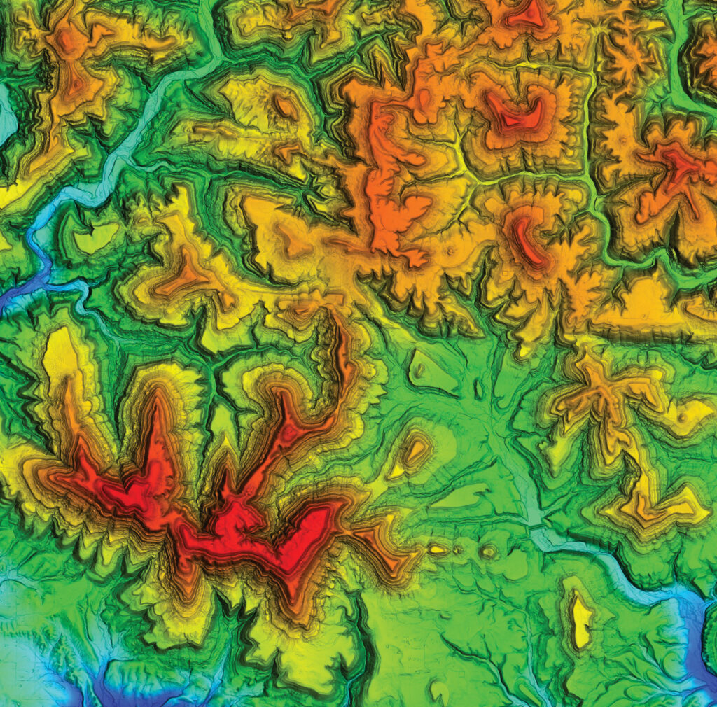
2024 3DEP data of the eastern hills of Arkansas. Image courtesy of United States Geological Survey.
Starting in December 2023, Woolpert flew the eastern half of the state, moving south to north, because the vegetation would stay leaf-off in the northern part of the state until the end of March 2024. Flight lines were planned in advance, but each day’s flying assignments were determined by weather and where the ground was clear and exposed—without snow or seasonal flooding.
During the lidar data acquisition, Woolpert field crews surveyed separate GNSS ground control points and checkpoints. Tied to the local coordinate system with the Continuously Operating Reference System network, the control points were used to relate the lidar measurements to Earth and the flight lines to each other during processing. The checkpoints were used for independent quality assessment.
Woolpert processed the raw lidar data to generate three primary deliverables—a classified point cloud, bare earth DEM, and extracted hydrographic breaklines. The classes included basic categories of vegetation, bare ground, and water bodies. Eastern Arkansas features a unique agricultural land class, known as Green-Tree Reservoirs, which are purposely flooded after the growing season to attract migrating waterfowl for hunting purposes. These temporal water bodies were not present in every farm field but were identified as their own class.
Thanks to the careful, yet flexible, flight planning, Woolpert covered half of the state in a single flying season as requested by Arkansas. This accomplishment improved the overall quality of the data due to acquisitions being conducted under consistent ground and weather conditions.
Following the completion of the eastern Arkansas data collection in March 2024 and subsequent processing, Woolpert delivered the elevation products along with metadata and checkpoints to USGS for quality assessment. Depending on file size, the GIO delivers products via online and hard-drive methods to interested state agencies and private sector engineering firms at no charge. The data is also incorporated into The National Map for use by the general public.
Leveraging 3DEP in Arkansas
The GIO resides within the state’s GIS office, which is a division of the Arkansas Department of Transformation and Shared Services. The GIO makes use of 3DEP data for visualization projects while serving as the data warehouse and distribution center. The majority of the derived elevation products are employed in engineering and science applications. In many cases, these projects are performed jointly by state and federal offices and are as diverse as the Arkansas landscape.
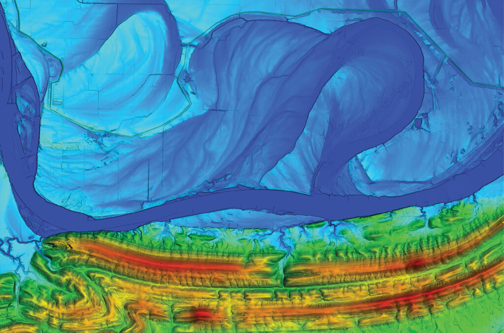
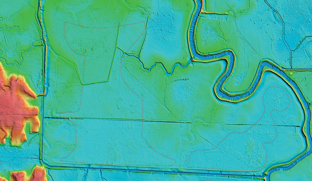
3DEP data of oxbow in eastern Arkansas. Image courtesy of United States Geological Survey.
One of the most important 3DEP applications that will become even more effective with the availability of the 8 ppsm refresh data is an ongoing initiative called irrigated land leveling. Spearheaded by the U.S. Natural Resources Conservation Service, this process yields dual success by simultaneously conserving precious surface water and reducing irrigation costs for Arkansas rice growers.
Totaling about 1.4 million acres, rice fields are plentiful in the southeastern part of the state near the Mississippi River Delta. This form of agriculture is irrigation-intensive and requires a constant, minimum water coverage for rice production. In fields with uneven or sloping topography, an excessive volume of water is needed to cover all spots, including the high ones, to a minimum depth. Then, low points are often submerged in considerably more water than is needed.
This comparison of Google Airbus 2024 data (top) and 2024 3DEP (bottom) at the top of page 9 shows how the 3DEP data is used to help manage rice field flooding.
The data enables government agencies to identify the fields that have not been leveled, in order to target education, training, and outreach on the benefits of land leveling. This effort is especially impactful on water conservation as the state transitions from aquifers to surface water for agriculture.
The land leveling process involves grading fields with earthmoving equipment to level out the terrain’s highs and lows. At an average volume of 27,000 gallons per acre-inch, the potential water savings associated with level fields are staggering. According to a report in the Arkansas Democrat-Gazette1, the typical unleveled Arkansas rice field averages 30 inches of water coverage, while a leveled one only needs 18.
As indicated earlier, another agriculture-related application of 3DEP data is Green-Tree Reservoir (GTR) management. The elevation data can be used to identify wooded lowlands often found on agricultural properties that could be converted to GTR if the landowner is interested. Once flooded, GTRs are typically leased out for duck hunting, which adds a significant revenue stream to the owner and the local economy.
Since most flooding is not desired, urban planners and engineers rely on elevation data to perform stormwater flow modeling in the planning of new streets and curbs or any construction project that alters the landscape. This kind of hydrologic mapping also is useful in smaller, microsite engineering projects when a single structure, such as a store or restaurant, is built. These commercial development projects stand to benefit most from the newer 8 ppsm data.
The increased point density will improve the quality and precision of 3DEP applications, each in its own way, but the overall advantage will be experienced in terms of return on investment. Higher-density data enables civil engineers, whether leveling a farm field or preparing a building site, to do more topographic planning and preliminary design in the office before dispatching a survey crew to spot-check plans in the field. Users can enjoy significant savings, in terms of both time and money.
The GIO’s strategy is to make the best-quality data freely available to the commercial sector, just as it does for government projects. This promotes development and drives economic growth, earning Arkansas a reputation as a good place to do business, which is in the best interest of the state and its taxpayers. 
Sidebar
3DEP Success and Evolution
By any metric, 3DEP has been successful and it keeps improving thanks to continuous evolution in procedures and technologies. In 2012, the program was expected to achieve an annual nationwide return on investment of $690 million for private and public stakeholders. Today, this annual return on investment calculation has soared to $7.6 billion for the next generation of 3DEP if fully implemented.
According to USGS, the goal to provide the first-ever national 3DEP baseline has remained consistent since the first full year of 3DEP production in 2016. Goals for the next generation of the program are to provide higher-quality data at an increased frequency and to integrate inland bathymetry data. The 3DEP specification is continually evolving and improving.
Funding for the 3DEP baseline has depended heavily on partnerships, as does the next generation program. 3DEP has amassed over 350 partner organizations over the years, and about 60 to 65% of the overall program cost is funded by partners.
The changes in goals from the baseline to the next generation of 3DEP are driven by documented user needs in the 3D Nation Elevation Requirements and Benefits Study, conducted by USGS in partnership with NOAA. These needs have grown because of improvements in technology and data quality, as well as the increased accessibility of data as 3DEP coverage has expanded.
One of the primary benefits of 3DEP for participating states is the availability of cost sharing through a fair and open process known as the annual Data Collaboration Announcement. USGS funding provides up to 50% of costs, and USGS and other federal funds are often used to expand the footprint of the survey area. States benefit from USGS expertise in contracting for data acquisition, the USGS lidar data validation process to support data meeting 3DEP quality standards, and the public availability of lidar data through The National Map products and services.
This unified approach to data acquisition also benefits USGS and other federal partners by reducing unit costs through pooled funding and economies of scale achieved with larger project sizes. The participation of funding partners in 3DEP also makes lidar datasets publicly available, supporting the mission-critical needs of USGS and other federal agencies.
Shelby Johnson is the Director of the Arkansas Geographic Information Systems (GIS) Office. He has over 30 years of experience in the geospatial disciplines. Under his leadership the State of Arkansas has completed numerous statewide framework data sets that serve as the state’s spatial data infrastructure. These include several statewide digital orthoimagery collections, the completion of in an initial Quality Level 2 lidar dataset and a robust set of boundaries, roads, addresses and parcels that are used daily by federal, state, and local governments to make better decisions to improve the lives of Arkansans. Shelby was instrumental in organizing the State GIS Board and is responsible for assisting it in building a coordinated GIS system to meet the needs of people in Arkansas. Shelby is a native of Madison County and attended the University of Arkansas, where he obtained a Bachelor of Arts degree in Geography. He resides in Little Rock with his wife, Belinda, and one son.
Sam Moffat is a Geospatial Project Director at Woolpert, with expertise that encompasses all aspects of the industry, together with specialized knowledge of large-scale state, local government, and federal mapping efforts. He keeps abreast of emerging technologies and the benefits of digital data collection, including aerial imagery and airborne lidar, and has successfully managed five statewide mapping programs. In addition to managing and directing projects, Sam is well-versed in fostering sustainable relationships and assisting organizations to leverage geographic information to drive business value and operational efficiencies.