Editor’s Note: The following appeared in the September 2023 of the Hydrographic Review Panel newsletter
The current decline in the geodetic capacity in the United States is at a crisis point that is a threat to our economy, international competitiveness and national defense. The current shortage of practicing geodesists, the number of students in the pipeline to become geodesists, and the reduced number of U.S. geodetic academic programs directly undermines the essential role NOAA’s National Geodetic Survey (NGS) plays in accurate positioning services nationwide. It more broadly affects any NOAA program that relies on the fundamental geospatial framework, and in particular the programs of the Office of Coast Survey (OCS) and Center for Operational Oceanographic Products and Services (CO-OPS).

In January 2022, the American Association of Geodetic Surveying posted on its website a white paper authored by prominent non-governmental subject matter experts addressing the issue titled “The Geodesy Crisis: America’s loss of capacity and international competitiveness in geodesy, the economic and military implications, and some modes of corrective action”.
This paper lays bare the need to take immediate action because it takes time to:
- Train geodesists at the remaining geodetic-related academic programs in the U.S.
- Expand the number of geodetic and geomatic programs in the U.S. and populate the programs with students.
What is geodesy and why is it important that the U.S. gains leadership in geodesy-related research and training?
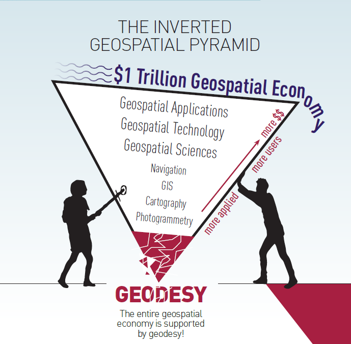
Geodesy is the science of measuring and monitoring the size and shape of the Earth and the location of points on its surface. Without geodesy, the Global Positioning System and other Global Navigation Satellite Systems will not operate properly. Geodesy is the foundation science that supports all navigation, surveying, mapping, timing, geographic information systems, and numerous other activities. This doesn’t include the critical role of geodesy to support our troops and the defense of our country.
Geodesy Crisis Impact to the United States
Geodesy underpins most military platforms and systems. If the U.S. geodesy crisis is not resolved, the U.S. government, industry and academia will be unable to compete with Europe, let alone China, in geodesy and geodetic technology. This loss of competitiveness threatens our national security and will cause a dramatic reduction of America’s share of the more than $1 trillion per year geospatial economy. The most immediate threat to geodesy in America is the loss of academic training capacity. Without immediate and sustained industrial-scale investment in basic research and graduate training, the few remaining geodesy programs around the country will shrink rather than grow, and America will no longer be able to train itself out of the crisis. The loss of competitiveness would then become permanent.
Current U.S. government agency activities related to the Geodesy Crisis
To address the difficulty filling critical technical geodesy positions with qualified U.S. citizen applicants, leadership from NGS, the National Geospatial Intelligence Agency (NGA), and the National Aeronautics and Space Administration (NASA) have formed the Geodesy Community of Practice. Together these agencies are developing a multi-pronged strategy to increase collaboration and coordination on geodesy education, training, research, fieldwork, and funding opportunities to rebuild the geodesy tradecraft pipeline. Under recent funding levels, NGS’ ability to implement many of the recommendations from this group will remain severely limited. In FY 2023, NGS was funded to award ~$4 million in Geospatial Modeling Grants which now provides NGS a direct mechanism to address the crisis, as long as it continues to be funded in the appropriations process into the future.
Why do we have a Geodesy Crisis?
Since the 1990’s, U.S. academic programs have reduced focus on geodetic academic research and graduate training in geodesy due to a significant decrease in government funding and associated perceived lack of interest. While the U.S. was reducing geodesy-related research and training, China was dramatically increasing funding and activities in geodesy research and training.
Recommendations for NOAA Action:
- Join the other government leaders and academia in raising the geodesy crisis to the highest level of government to warn of impacts to national security and economic growth.
- Advocate for the designation of geodetic infrastructure as national Critical Infrastructure.
- Support increased investment in the Geospatial Modeling Grants that promote and increase academic and government relationships, training and research activities in geodesy, surveying and related geospatial areas, and rebuild the pipeline for students to follow a geodesy and geomatics career path.
- Sponsor early and mid-career academic training, details, internships, and research work in geodesy and geomatic fields.
- Promote the modernized National Spatial Reference System (NSRS) and communicate the value of an updated, consistent, national coordinate system to support mapping, charting, navigation, infrastructure development, floodplain analysis, resource evaluation surveys, and many other scientific and management applications.
- Endorse requirements for U.S. government agencies to adopt the NSRS for all geospatial data and transition to the modernized NSRS expeditiously upon release.
- Encourage the adoption of the modernized NSRS by state, regional, local and tribal governments as well as the private sector and academia, to make their geospatial data more readily interoperable with government data.
- Proactively engage with national and international geospatial Standards Working Groups, such as the Federal Geospatial Data Committee and International Organization for Standardization to help ensure that the benefits of the modernized NSRS and advances in geodesy are applied to improve socio-economic, environmental, ecological, intelligence, and military programs.
In October 2003, Secretary of Commerce Don Evans established the HSRP as directed by the Hydrographic Services Improvement Act of 2002, Public Law 107-372. Panel members, appointed by the NOAA Administrator, include a diverse field of experts.
HSRP Members 2023
Ms. Mary Paige Abbott
Dr. Nicole Elko
Mr. Eric Peace
Dr. Qassim Abdullah
Mr. Lindsay Gee
Mr. Edward J. Saade
Capt. Anuj Chopr
Ms. Deanne Hargrave
Ms. Julie Thomas (Chair)
Capt. Alex Cruz
Capt. Anne McIntyre
Mr. Gary Thompson
Mr. Sean M. Duffy, Sr. (Vice Chair)
Dr. H. Tuba Özkan-Haller
Mr. Nathan Wardwell