Among the world’s most biodiverse ecosystems, tropical dry forests serve as vital carbon sinks and are teeming with life that supports human existence. However, as environmental changes accelerate, these precious habitats face unprecedented threats. The urgency to understand and manage these issues effectively has never been greater. Enter light detection and ranging (lidar) technology—a revolutionary tool in forest management and conservation.
Lidar has transformed our ability to explore and manage forested regions, offering unparalleled accuracy and detail. This cutting-edge technology has become indispensable for forest managers and environmental researchers. It enables precise biomass estimates, aids in ecological studies, predicts fire behavior, and tracks deforestation patterns, leading to more informed decision-making.
By providing detailed insights into forest structure, composition, and dynamics, lidar-derived information enhances our understanding and facilitates the development of more efficient conservation plans and sustainable land management practices. Moreover, modeling above-ground biomass with lidar is crucial for evaluating carbon sequestration potential, which is a key strategy in combating climate change.
Lidar is also essential for assessing wildfire risk. Capturing intricate terrain features and forest structures helps predict forest flammability patterns. These data allow fire experts to model fire spread, assess risks, and devise effective fire management and suppression tactics.
Most critically, lidar plays a pivotal role in monitoring deforestation and forest degradation with unprecedented spatial resolution. Providing precise and up-to-date information on land cover changes supports efforts to combat illegal logging, land conversion, and other drivers of deforestation, thus contributing significantly to global forest preservation initiatives.
In this groundbreaking conservation project, we utilized full-waveform lidar data to map Ecuador’s tropical dry forests. By deploying the RIEGL LMS-Q680i airborne laser scanner, aerial photography, AI algorithms, and sophisticated software from suppliers such as rapidlasso (LAStools) and BayesMap Solutions, we combined cutting-edge technology with advanced data processing methods, including machine learning algorithms for data analysis and regression. This represents a major leap forward in our ability to understand, manage, and protect invaluable forest ecosystems.
The Anna Lotta Biosphere Reserve: a sanctuary under threat
Perched along Ecuador’s Pacific coast lies the Anna Lotta Biosphere Reserve (Figure 1), a region characterized by xerophytic ecosystems, including increasingly rare tropical dry forests. These forests have suffered a staggering loss of over 70% of their original extent and face severe threats from climate change and human activity. Located in Ecuador’s most densely populated region, these forests are in the area most affected by climate change and have undergone severe drought periods, as reported by Ecuador’s Ministry of Environment, Water, and Ecological Transition.
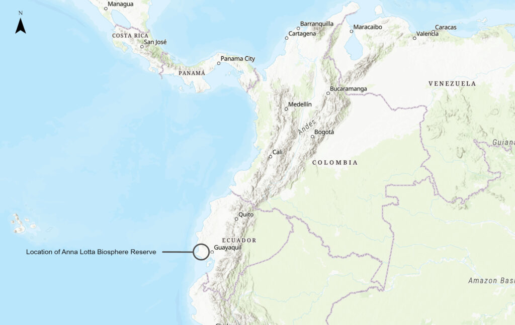
Figure 1: The Anna Lotta Biosphere Reserve is in western Ecuador.
Globally, tropical dry forests are among the most endangered ecosystems, surpassing tropical rainforests in terms of vulnerability. In Ecuador, rampant degradation and deforestation have led to significant fragmentation, necessitating new protective measures and vigorous monitoring of land use changes.
Our project area encompasses tropical dry forests on Ecuador’s southern coastline within the Tumbesian-endemic zone. These forests are in a better state of preservation than those on the central and northern coasts of Ecuador and northern Peru. Renowned for their intricate ecological interactions and immense environmental importance, these forests are a focal point in the fight against climate change.
The main purpose of the Anna Lotta Biosphere Reserve is to safeguard and maintain tropical dry forests within this privately held woodland in Ecuador for enduring carbon sequestration and biodiversity conservation. Its climate-related aim is to prevent emissions from deforestation and degradation.
Since 2007, the reserve has been under the stewardship of its proprietor, Dr. Jaime Rocero Maquilón, a German-Ecuadorian physician who is deeply committed to environmental preservation. Dr. Rocero’s vision extends beyond merely conserving the forest and aims to inspire similar initiatives across Ecuador. By leveraging carbon credits to improve forest management, he plans to fund ongoing biodiversity conservation efforts and enhance the ecological health of the area.
Carbon funding will support crucial maintenance tasks, such as introducing local tree species for restoration, improving fencing, and enhancing surveillance and monitoring. Additionally, it will support environmental education programs for nearby communities and other vital activities.
Green carbon mapping: a technological leap
In January 2024, our team embarked on a mission to capture detailed data over the Anna Lotta Biosphere Reserve using a RIEGL LMS-Q680i sensor, an airborne laser scanner designed for long-range applications. This state-of-the-art equipment is particularly effective for aerial surveys in varied terrains, making it ideal for mapping intricate landscapes of the reserve. Moreover, it helped us to create a faithful and accurate record of the existing forest, which will serve as a baseline for monitoring this area in the coming years.
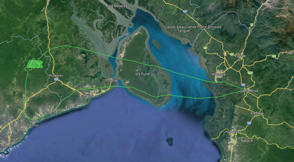
Figure 2: Flight path carried out above the Anna Lotta Biosphere Reserve.
The dataset we analyzed contained full-waveform lidar data collected from a single flight over the reserve (Figure 2). Acquired by Stereocarto, a leading geospatial services company operating in Europe and Latin America, the data provided a wealth of information about forest structure and composition.
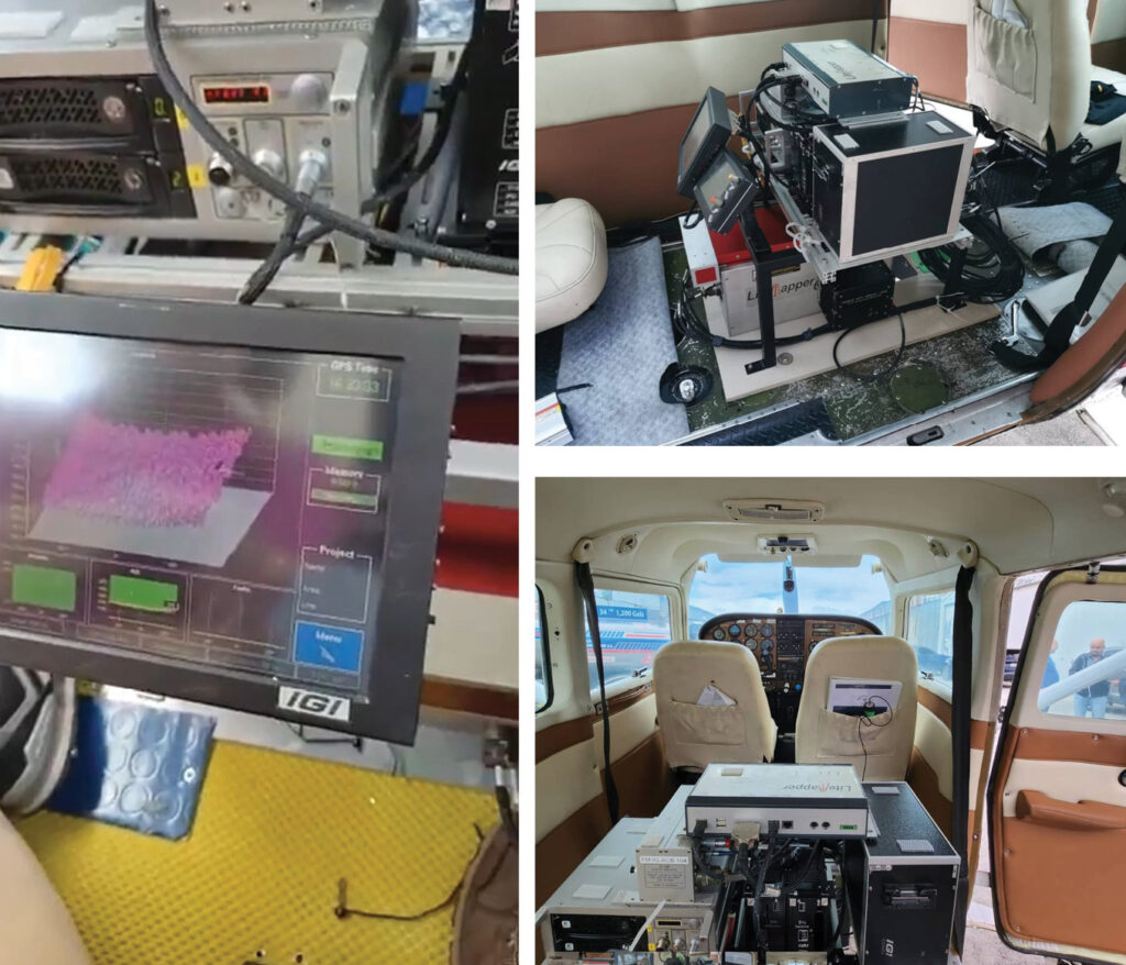
Figure 3: The RIEGL LMS-Q680i system was mounted on a Cessna 206 airplane. The sensor operates at a wavelength of 1550 nm and was set to 400 kHz. The flight was conducted at an altitude of 700 m above ground level, with an average speed of 85 knots.
The RIEGL LMS-Q680i boasts advanced features, including a powerful laser source, multiple-time-around (MTA) processing, and digital full-waveform recording (Figure 3). These attributes allow efficient operation in Ecuador’s challenging environments by capturing data with remarkable precision.
Why full-waveform lidar?
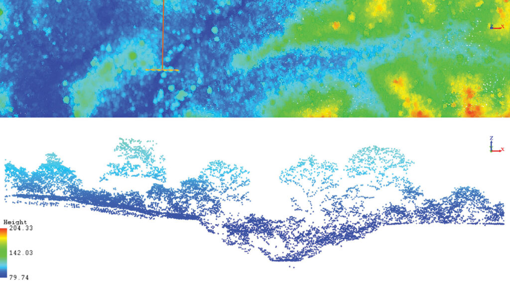
Figure 4: Vertical profile of a tropical dry forest in the Anna Lotta Biosphere Reserve.
Utilizing full-waveform lidar data brought numerous benefits to our project (Figure 4):
- Enhanced analysis of vegetation structure: Full-waveform lidar captures the complete reflected signal, offering detailed insights into the vertical structure of vegetation, from the canopy and sub-canopy to branches, trunks, understory, and ground surface. This enables a more precise evaluation of forest biomass and vegetation layers.
- Improved ground identification: Since the entire waveform of the laser pulse is recorded, it becomes easier to differentiate between the forest canopy and the ground, even in densely vegetated regions.
- Higher point density: Full-waveform lidar data often result in a greater density of data points, enhancing the resolution and intricacy of the collected data. This is particularly advantageous for detecting small features and changes within the forest.
- Enhanced object categorization: The additional information from full-waveform lidar aids in distinguishing between various types of vegetation and other objects in the forest, leading to more precise classification and mapping.
- Penetration through thick canopy: Full-waveform lidar is more efficient at penetrating dense canopies and capturing data from multiple layers within the forest—a crucial capability for examining forests with thick vegetation where traditional lidar methods may struggle.
- Increased precision in biomass estimation: The detailed vertical profiles and forest metrics acquired from full-waveform lidar enhance the precision of biomass estimation, which is essential for ecological research and forest management.
- Improved detection of understory vegetation: Full-waveform lidar excels at detecting and characterizing understory vegetation and provides vital information for fire behavior and combustibility modeling, biodiversity research, and habitat assessment.
Unveiling the forest’s secrets
In this groundbreaking study, our team harnessed advanced lidar technology and machine learning algorithms to map and analyze the Anna Lotta Biosphere Reserve. The project not only produced a highly detailed topographical survey of the reserve (Figure 5), but also offered crucial data on biomass and carbon stock estimations, underscoring the importance of innovative technologies in environmental conservation.
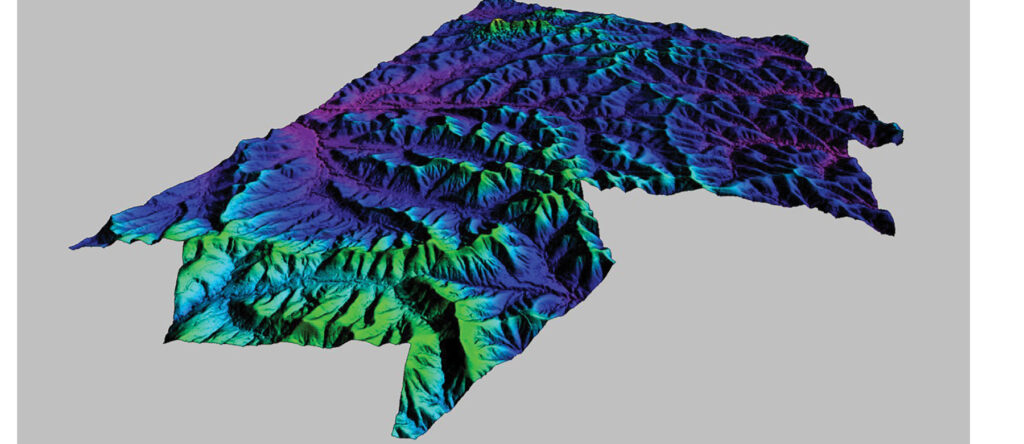
Figure 5: Digital terrain model of the Anna Lotta Biosphere Reserve.
We collected full-waveform lidar data over the 2500-hectare reserve, processing it with tools such as LAStools and BayesMap WavEx, alongside machine-learning algorithms in the R programming language. This approach allowed for an unprecedented level of detail in capturing the forest’s structure and composition.
The data was projected using the WGS84/UTM zone 17S coordinate system, with elevations adjusted via the EGM2008 geoid model to ensure precise height measurements.
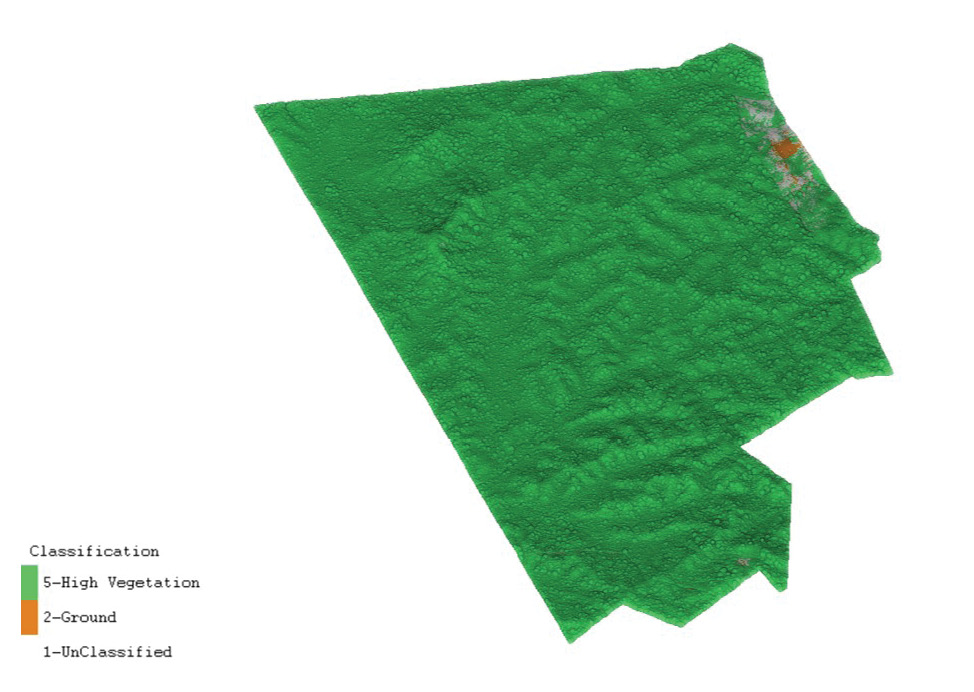
Figure 6: Classified lidar point cloud of Anna Lotta Biosphere Reserve.
We collected approximately 1.62 billion laser point records, adhering to LAS specification version 1.4. Due to the dense forest coverage, the majority of these points, 620 million, were first returns. We achieved a high point density of 30.35 points per square meter (ppsm) for all returns and 11.62 ppsm for last returns only—essential for accurate ground surface modeling (Figure 6).
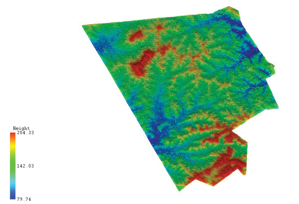
Figure 7: Lidar point cloud of Anna Lotta Biosphere Reserve.
The intensity values of the laser returns ranged from 0 to 25,827, indicating varied surface reflectivity within the forest environment. Elevation values spanned from 58 to 235 m, reflecting the reserve’s complex topography and diverse vegetation (Figure 7).
Ensuring data accuracy
To guarantee the accuracy of the dataset, we conducted comprehensive quality control using rapidlasso’s LAStools QC capabilities and BayesMap Solutions’ FastQC tools. This process involved generating detailed raster images that enhanced data analysis and pinpointed potential issues. The following quality control measures were key:
- Time intervals and overlap maps: Automated determination of high-frequency IMU drift correction intervals and visualization of overlapping swaths are critical for accurate registration.
- Relative time deviation plots: Identification of self-overlap issues and multi-channel mixing ensured precise timestamp mapping.
- Roughness maps: Visualization of terrain properties aided in understanding vegetation types and natural terrain features.
- Height maps: Provided essential elevation data for further analysis.
- To correct the initial data inaccuracies, we used BayesMap Solutions’ strip-alignment feature to fix significant misalignments and systematic errors. The strip alignment process involved several key steps:
- Quality checks before and after alignment: Ensured data consistency and integrity throughout the process.
- Data tiling and gridding: Organized the data into manageable sections for efficient processing.
- Projection and geometry validation: Synchronized and validated the dataset’s geometry to ensure spatial accuracy.
- Optimal correction calculations: Adjusted misalignments based on registration results to refine the dataset.
- Generating visual metrics: Vector images and statistical outputs were created to assess the effectiveness of the corrections.
- Producing corrected files: Generated a fully corrected LAS/LAZ dataset ready for application.
After applying these corrections, the root-mean-square (RMS) residual vertical error was impressively reduced to 0.055 m. This significant improvement demonstrates the effectiveness of the correction methods and highlights the crucial role of advanced data extraction and processing algorithms for aerial lidar data.
Revealing new insights
Our study (Figures 8, 9 and 10) revealed differences in biomass and carbon storage between the Anna Lotta Biosphere Reserve and the official Ecuadorian national averages for tropical dry forests, highlighting the importance of site-specific data.
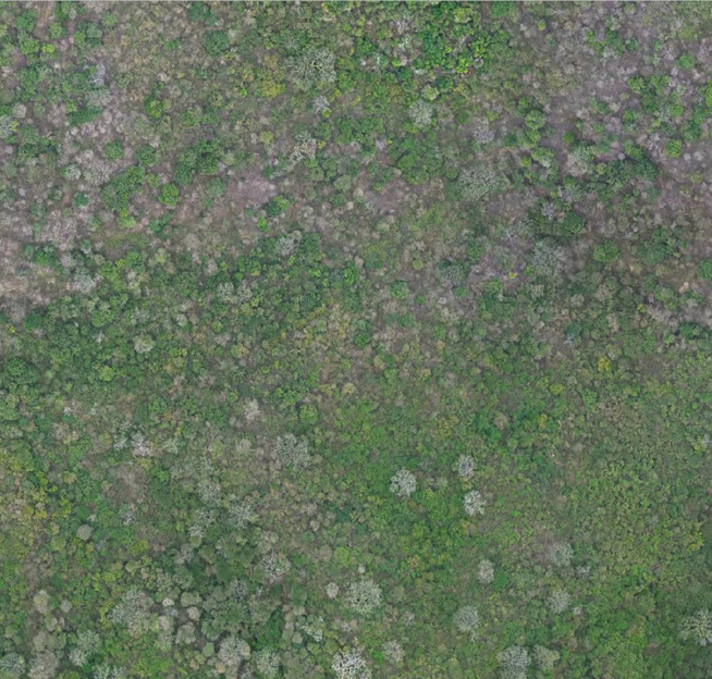
Figure 8: Aerial RGB photograph of Anna Lotta Biosphere Reserve at 5 cm/pixel resolution.
While the National Forest Inventory reports an average basal area of 9.1 m² per hectare, a volume of 53.9 m3 per hectare, and carbon storage of 37.0 megagrams of carbon per hectare (Mg C·ha⁻¹), the Anna Lotta Biosphere Reserve field forest inventory showed a basal area of 8.2 m² per hectare, a volume of 49.11 m3 per hectare, and higher carbon storage at 44.34 Mg C·ha⁻¹.
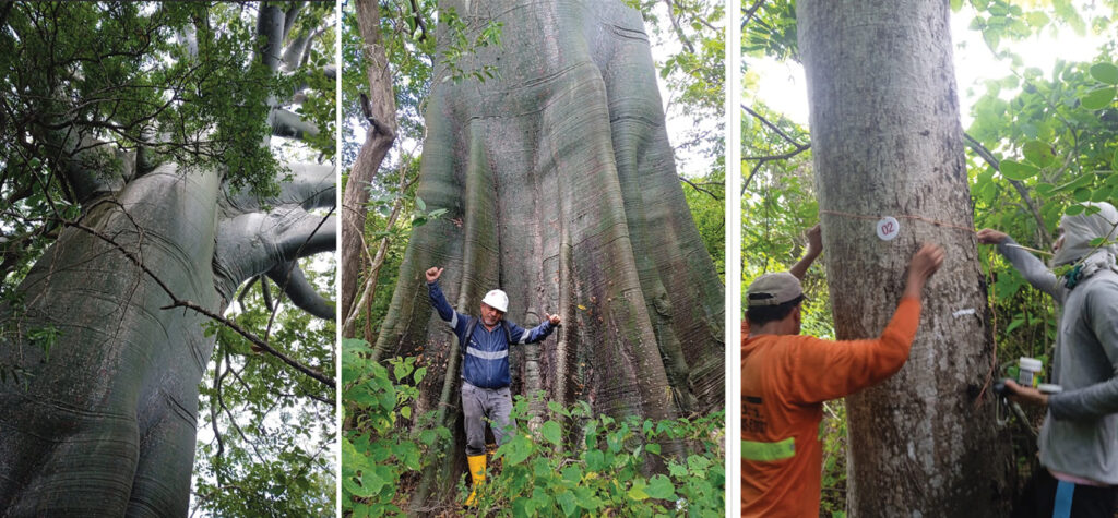
Figure 9: Field forest inventory conducted at the Anna Lotta Biosphere Reserve.
Using lidar data and support vector machine (SVM) regression models, we estimated the above-ground biomass (AGB) for the reserve at 104.42 Mg ha⁻¹, with a carbon stock of 49.08 Mg C·ha⁻¹ and an equivalent carbon dioxide sequestration of 180.12 Mg CO₂ per hectare. These findings emphasize the reserve’s unique characteristics and demonstrate how advanced technologies can provide more accurate and localized environmental data.
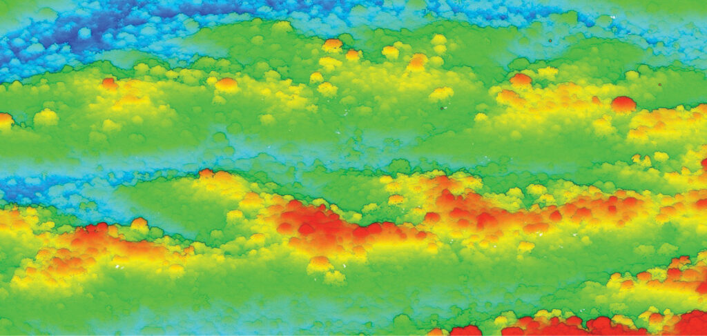
Figure 10: Detailed forest mapping in the Anna Lotta Biosphere Reserve using lidar point-cloud technology.
From voxelization to forest digital twins
A key aspect of our project was the voxelization of tropical dry forests (Figure 11) and the generation of a forest digital twin (FDT). What is the difference between a voxelized forest model and FDT?
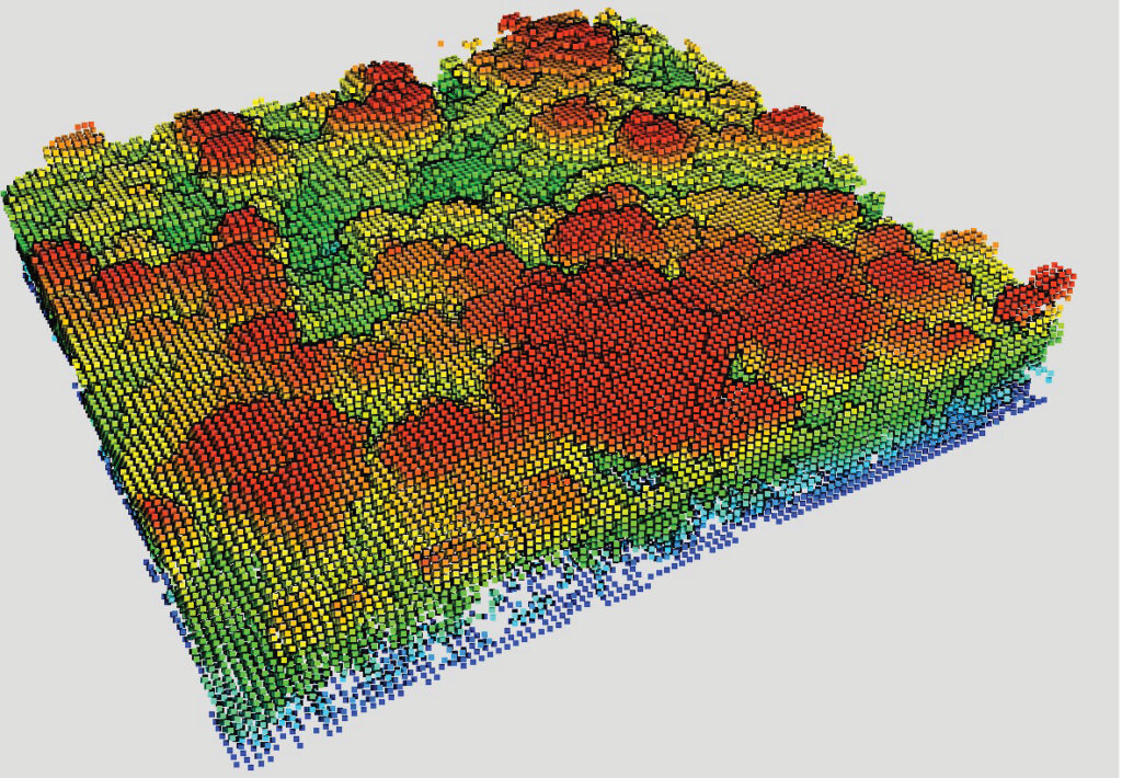
Figure 11: Voxelization of lidar point cloud in Anna Lotta Biosphere Reserve.
A voxelized forest model is a static, three-dimensional representation in which the forest space is divided into small cubic units called voxels. Each voxel contains detailed information about the physical characteristics at a specific location, such as vegetation density, canopy height, and biomass distribution. This model focuses primarily on capturing the structural complexity and spatial attributes of the forest at a specific point in time, aiding in morphological analyses, and contributing to biomass estimation and carbon-balance studies.
In contrast, an FDT is a dynamic, multidimensional virtual replica of a forest ecosystem that goes beyond mere structural representation. An FDT integrates structural data with ecological processes, temporal dynamics, and biological interactions, continuously updating real-time data from various sources, such as aerial or terrestrial sensors and satellite data.
Conclusion: a technological beacon for conservation
This pioneering work in the Anna Lotta Biosphere Reserve showcases the transformative power of combining cutting-edge lidar technology with sophisticated data processing and machine learning techniques. By providing a more nuanced and accurate picture of forest biomass and carbon stocks, our study not only advances scientific understanding but also equips policymakers and conservationists with the tools necessary to make informed decisions in the fight against climate change.
Additionally, this initiative contributes to the production of high-quality carbon credits, enhancing the credibility of climate pledges. Each issued credit signifies a verified ton of carbon removal. By providing complete transparency and monitoring the process using the most reliable data for independent verification, we guarantee that stakeholders can rely on the genuine climate impact. Entrusting precise measurements to experts ensures that project contributions result in tangible and quantifiable environmental advantages.
As we continue to refine these technologies and methodologies, we will move closer to a future where we can monitor and protect our planet’s most vulnerable ecosystems with unprecedented precision. The Anna Lotta Biosphere Reserve is a testament to what can be achieved when innovation meets dedication in the pursuit of environmental conservation.
References
RIEGL Laser Measurement Systems: www.riegl.com
BayesMap Solutions software: https://bayesmap.com/products/bayeswavex/
rapidlasso LAStools software: https://rapidlasso.de/
R Programming language: https://www.r-project.org/
Stereocarto: www.stereocarto.com
lidar Latinoamerica: https://www.lidarlatinoamerica.com/