Today, Thomas Jefferson’s Monticello ranks as one of the most important historical sites in the United States. Two centuries ago, Monticello was a 5,000-acre plantation that was home not just to Jefferson, but also to hundreds of enslaved people and their families, producing tobacco and later wheat for sale on Atlantic markets. The ongoing interdisciplinary study of the Monticello landscape, the artifacts that lie under it, and surviving documents are providing 21st century Americans with a much clearer understanding of the property and the lives of all its residents than we had a decade ago.
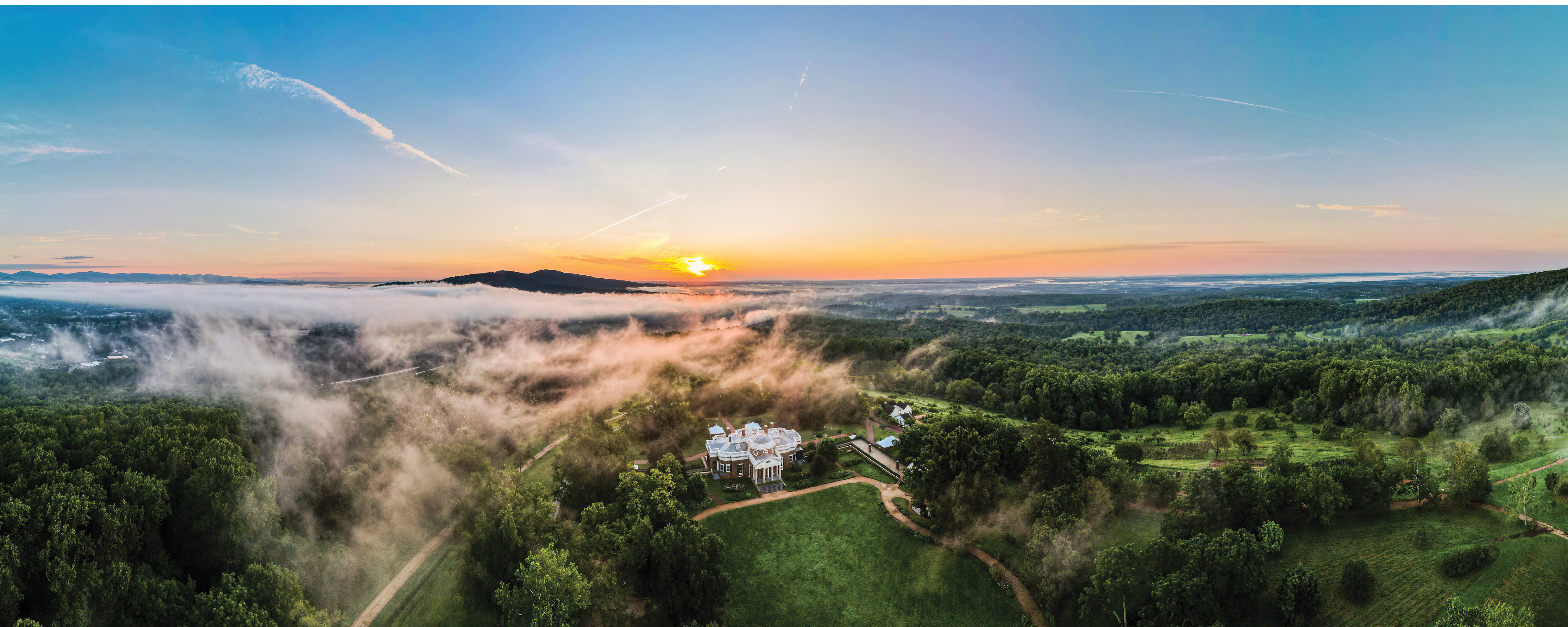
Thomas Jefferson’s Monticello at sunrise.
One of the most important sources of new discoveries is the Monticello Plantation Archaeological Survey, an ongoing effort to locate all the archaeological sites and traces of past land use on the 2500 acres currently owned by the Thomas Jefferson Foundation, the non-profit responsible for Monticello’s preservation and interpretation. Achieving the Plantation Survey’s goals requires accurate maps, and the accuracy of the maps available to the Foundation’s archaeologists has radically improved thanks to aerial lidar, which has the ability to reveal geographic detail that is otherwise undetectable. Lidar is proving to be a valuable tool in the modern archaeologist’s toolbox for uncovering secrets of the past.
Derek Wheeler, Research Archaeologist at the Thomas Jefferson Foundation, relates his reaction to seeing the features revealed by lidar data: “The level of detail that the lidar data provides is astounding—it’s like waking up in the morning and putting on my glasses. The world goes from fuzzy and indistinct to clear!”
Brad Barker, Director of 3D Mapping at Surdex, agreed about the increase in detail. “After walking the property of Monticello, I was amazed at the features that could be seen in the lidar. It is easy to forget the ruggedness of the natural landscape while viewing digital elevation models in the office!”
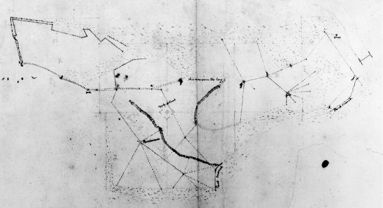
Early hand-drawn documents of Monticello Mountain agricultural fields (c. 1795).
Backdrop
Lidar itself is not new to archaeology, with the first instances of its use in the 1970s when European archaeologists used it to map castles and surrounding fields. Over the years it has proven particularly useful in regions where dense vegetation hides architectural ruins, for example pyramids, house compounds, and causeways of pre-contact Mayan sites in Mexico and Central America. In the United States, it has been very beneficial at sites like Cahokia near St. Louis, where Native Americans built monumental earthen mounds and plazas. At Monticello, archaeologists are using lidar to advance our understanding of both the massive amount of earth-moving required to construct the ornamental landscape around Jefferson’s mansion, as well as subtle and often otherwise invisible features in the plantation landscape.
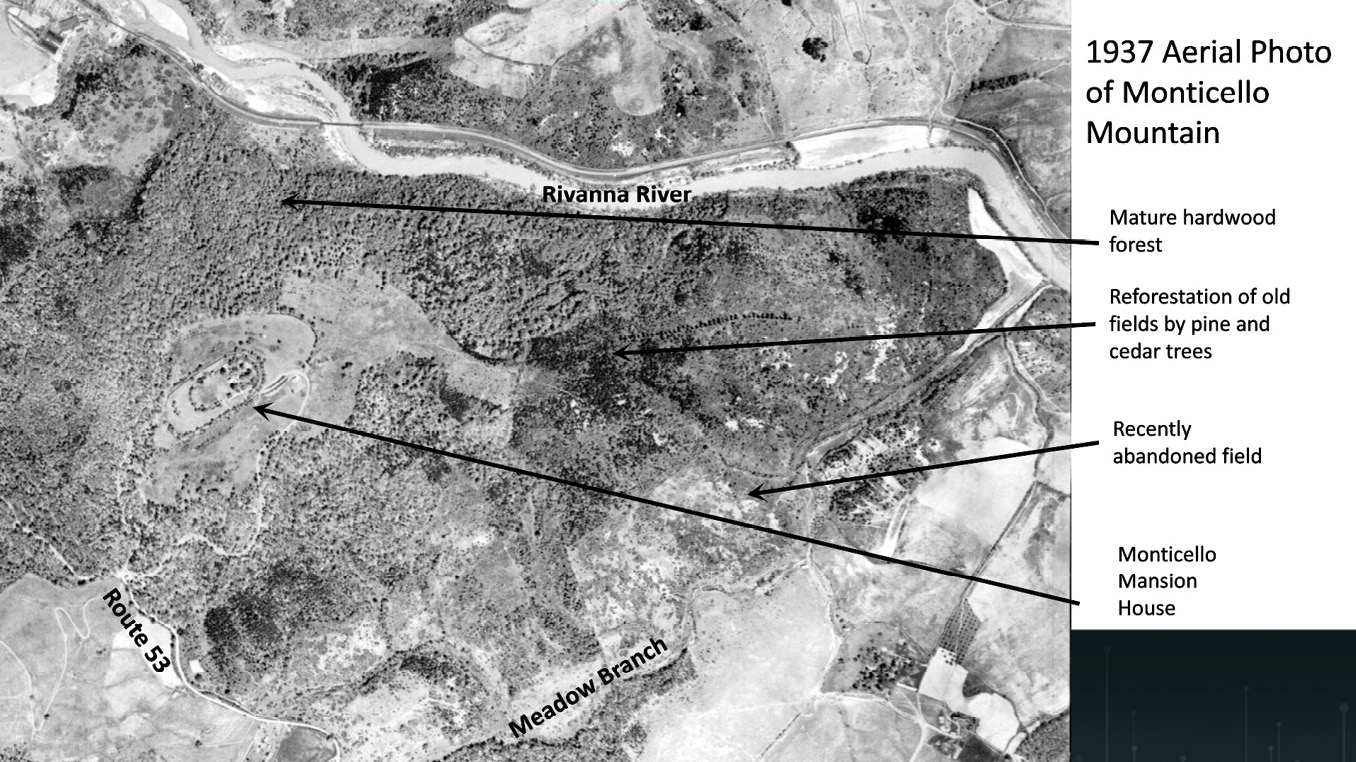
Aerial photograph of Monticello Mountain, 1937.
Modern efforts
At Monticello, modern archaeological research began in 1979 when the Thomas Jefferson Foundation assembled a team to investigate the Monticello mountaintop, including Jefferson’s mansion and Mulberry Row, a street adjacent to the mansion lined with the houses of free and enslaved laborers, as well as the shops and outbuildings in which many of them worked. Beginning in 1997, the Foundation launched the Monticello Plantation Archaeological Survey to explore the rest of the property, where Jefferson’s fields and the houses of enslaved agricultural laborers were located. Artifact concentrations indicating where people lived and worked are identified via excavation of shovel test pits dug at 40-foot intervals. Shovel test pits are circular holes 1-foot in diameter that are dug to subsoil, and soil and sediments are screened through 0.25” hardware cloth to reveal artifacts. So far archaeologists have dug 26,000 test pits, covering about a quarter of the Foundation’s property, and have discovered 28 archaeological sites.
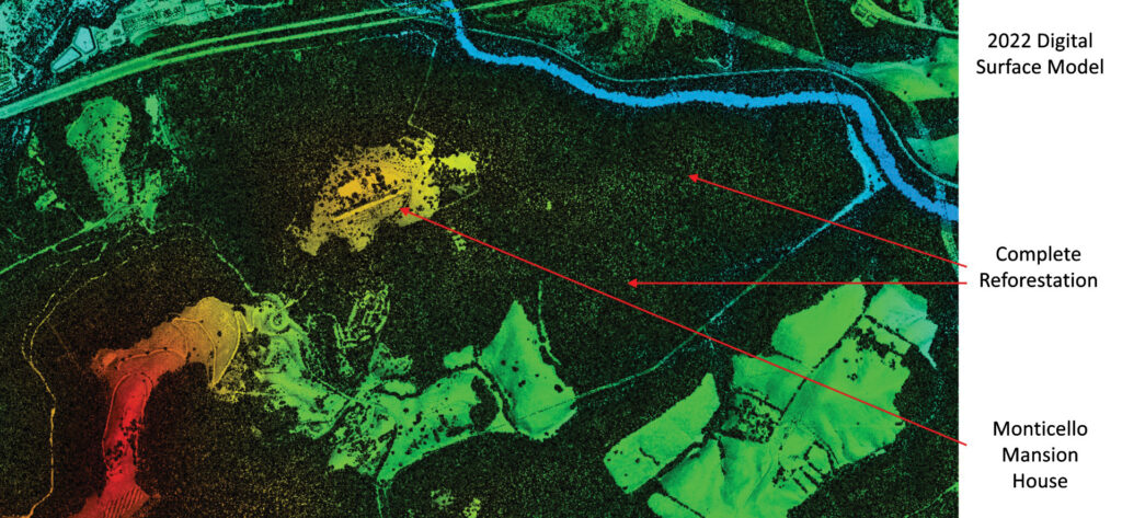
Monticello plantation, the final 2022 DSM revealing the extent of reforestation when compared to earlier data of mixed forested areas and cultivated farmland.
Lidar data is critical because it reveals surrounding landscape features that are not readily seen and identified by archaeologists working on the ground. The initial data used for this project consisted of 2016 USGS lidar data with 2 points per square meter (ppsm) density and a 1-meter digital elevation model (DEM). While even this low-density data enabled researchers to detect previously indiscernible details in the terrain, it did not provide the level of detail needed for more in-depth analysis. Archaeologists sought to increase the level of detail they could obtain from higher density lidar.
In 2022 the Monticello archaeology team contracted with Surdex Corporation, a geospatial company recognized for its commitment to quality data, for aerial lidar coverage of Jefferson’s original 5000-acre holding to document the ornamental landscape and identify subtle traces of past agricultural land use, including berms left by vanished fences and field boundaries, road traces, walls, long parallel ridges that mark orchards, and erosion gullies carved by agricultural runoff. Such features would provide clues for further investigation, including excavation.
Brad Barker, Surdex’s Director of 3D Mapping, flew to Virginia to meet with the Thomas Jefferson Foundation archaeological team, headed by Dr. Fraser D. Neiman, Director of Archaeology, and Derek Wheeler, Research Archaeologist. During the meeting, the archaeological team provided some history of previous efforts and discussed the objective of the 2022 project, to identify subtle landscape features that provide a fuller picture of the history of land use on the property.
Lidar project design and specifications
With the objective laid out clearly, the next step was to design the most efficient acquisition plan that would ensure the desired point density. The project called for the acquisition and processing of 33 square miles of 30 ppsm lidar.
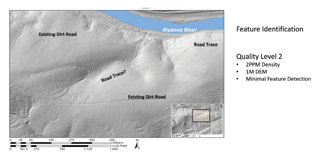
Monticello plantation, 1-meter DEM from 2 ppm lidar revealing roads.
Surdex’s design was to acquire the data with an Optech Galaxy Prime sensor at 1350 feet above ground level. As shown on the flightplan overleaf, there was a total of 25 flight lines at 60% sidelap to ensure complete coverage. Acquisition proved to be challenging because, by 2022, a significant portion of the project area had been reforested, obscuring the bare earth for clear lidar returns.
The processed 30 ppsm lidar data produced significantly enhanced digital elevation models with significantly higher clarity than the 2 ppsm USGS lidar that was publicly available. The berm and road trace lines are notably enhanced, and the rows of soil where orchards had been planted (previously undetectable) are readily visible.
The final deliverables for the project were a bare-earth point cloud, a 1-foot DEM, a 1-foot digital surface model (DSM) and a 1-foot intensity image.
New discoveries
The 2022 lidar data provides important new insights into changing spatial organization and land use at Monticello. Its analytical potential is enhanced by an archive of plats that were surveyed and drawn by Jefferson himself, as he laid out new agricultural fields and roads. Although distorted by survey errors, Jefferson’s maps provide valuable clues to the identity of anomalies seen in the lidar. Later historical maps are also useful. A 1923 survey plat, which shows property lines and ownership from 1833, affords a record of how pieces of Monticello were was sold off after Jefferson’s death in 1826. Early aerial photos are also important; for example, a 1937 aerial survey by the US Department of Agriculture shows the location of Jefferson’s wheat fields that continued in use for a century, soon after they were finally abandoned and reforestation had set in.
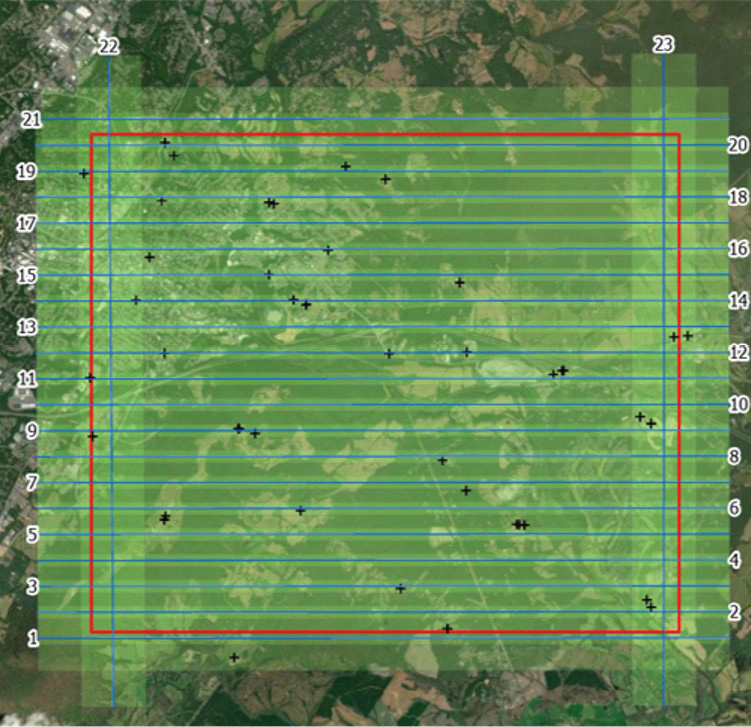
Surdex’s flight plan to acquire lidar data of the Monticello plantation at a density of 30 ppsm from a flying height of 1350 feet above ground.
The plantation landscape can be divided into two zones: an ornamental precinct that surrounded the mountaintop mansion and the agricultural precinct further down the mountain and across the low hills that surround it.
At the center of the ornamental precinct at the top of Monticello Mountain lay Jefferson’s mansion, carefully sited on level ground sculpted by the labor of enslaved workers. Lidar offers superb documentation of the results of their efforts: a perfectly flat surface, parabolic in plan, encompassing an area of two football fields.
Lidar reveals new traces of the “roundabout” road system that documents tell us was constructed in the 1790s. As recorded by Jefferson, enslaved workers cleared four roundabouts circling the mountaintop at successively lower elevations. A series of connector roads linked adjacent roundabouts. The roundabouts echoed landscape designs Jefferson saw in England on the estates of aristocrats. Segments of some of the roundabouts and connectors survive and are still in use today. But many other segments, missed in earlier mapping campaigns, can now be identified in the new lidar data and precisely located on the ground.
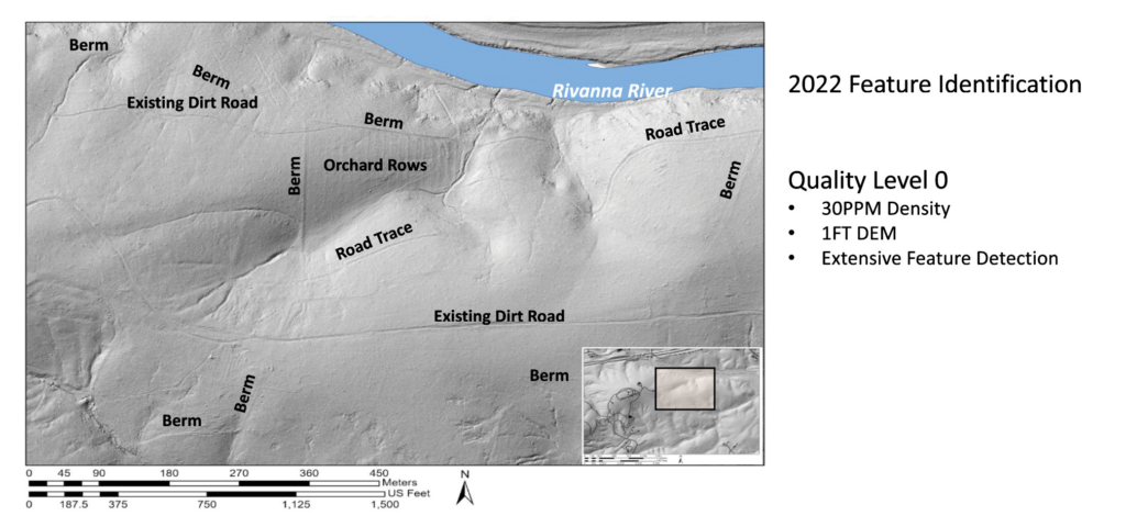
Monticello Mountain, 2022 bare earth with 1-foot DEM from 30 ppsm lidar revealing significant improvement in resolution over the previous 2 ppsm lidar.
Lidar also unveils previously unrecognized segments of what Jefferson called “the north road.” This was essentially the “scenic route” that snaked along the contours of the mountain’s steep, forested north slope and transported visitors to the mountaintop mansion, out of sight of the plantation’s agricultural fields.
Lidar also gives us new insights into two landscape features that fell outside the ornamental precinct but were the source material used to construct the mansion at its center. The first is the brickyard where hundreds of thousands of bricks were made. Lidar uncovers a long, low earthen berm stretching across a flat-bottomed, stream-fed ravine about a half-mile south of the mansion. On the upstream side of the berm the ground level was higher, an indication of impounded sediment behind it. The dam served to collect water required to process the clay for molding. The ground behind the dam was littered with small mounds which field testing revealed as piles of brick wasters (over-fired bricks). Another half-mile to the south, archaeologists identified a stone outcrop and the depression below it where tons of arkose (a coarse sandstone rich in feldspar) were quarried for use in constructing Monticello’s cellars and wings.
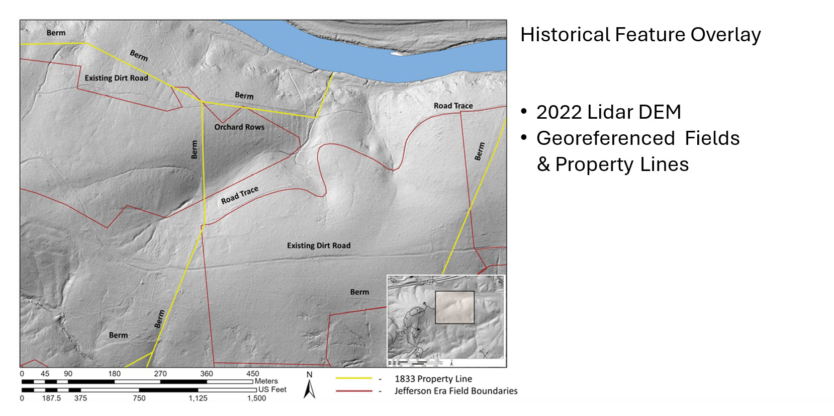
Monticello Mountain: the final 2022 DEM with overlays of the 1833 property lines and early 19th century field boundaries.
Lidar also provides new evidence of the plantation’s roads on which crops, and the enslaved people who grew them, moved. What Jefferson called the “east road” connected the mansion to the plantation’s fields and the fields to the Rivanna River, which carried crops to Richmond, Virginia, for sale on Atlantic markets. While segments of this road are still in use, there were no traces of it within a half a mile of the mansion. However, archaeologists can see the missing part in the lidar data.
Lidar data divulges yet more physical marks of past land use. For example, long-vanished fence lines left traces in the form of linear berms created by sediment trapped in the vegetation growing under them. The berms are traces of agricultural field and property boundaries. Some of them are visible today on the ground, but others can only be seen in the new lidar coverage. The locations of many berms match the property boundaries shown on the 1923 survey plat and date back to the division and sale of the plantation after Jefferson’s death a century earlier. However, some of them may mark the edges of Jefferson-era fields.
The new lidar coverage offers fresh insights into the locations of long-vanished orchards. These appear as parallel ridges averaging roughly 30 feet apart, left by tree rows and well-trodden paths between them. Most of these are invisible to an observer standing on top of them.
In the early nineteenth century, at the same time Jefferson was directing his overseers and enslaved field hands to start cultivating wheat as a cash crop, he also had these same people start additional building projects in an attempt at economic diversification, such as a series of mills along the Rivanna River. These include a grist mill designed to grind wheat into flour for the export trade; a toll mill that ground wheat and corn which was consumed locally; and a sawmill whose products were used at Monticello and neighboring plantations. The locations of the mills as well as traces of the canals that brought the water to power the mills can be seen in the lidar data.
Laying the groundwork for future research
A major focus of archaeological research at Monticello is the transition from the hoe-based cultivation of tobacco to plow-based cultivation of wheat in the 1790s. Lidar allows archaeologists to identify the effects of the plowing more accurately, including erosional gullies. Not surprisingly, it reveals that gullies are widest and deepest on the southern slopes of the mountain, where the wheat fields were located.
The gullies literally point to another important land-use trace visible in lidar: level areas below them where the eroded sediment was trapped by natural topography or rock walls. Locating trapped sediment opens the door to exciting future research opportunities. In previous work, archaeologists at Monticello discovered that similar erosion deposits are often deeply stratified. The bottom layers predate European settlement and are overlain by layers that span initial European settlement and tobacco cultivation, then the transition to wheat, and finally reforestation. By analyzing stratified sediment using a variety of scientific methods (for example, pollen analysis, sediment chemistry, and optically stimulated luminescence dating), archaeologists can decipher how Monticello’s residents altered the environment and the ways in which they had to adapt to these changes. The new lidar data helps archaeologists identify areas for this kind of scientific investigation.
Did you know there are three Monticellos?
- The mansion house,
- Monticello Mountain
(500+ acres), which is one of the plantation quarter farms, and - The 5000-acre Monticello Plantation.
Editor’s note: For additional discussion with the authors, check out episode #4 of our podcast.