Accurate geospatial data on surface water and drainage is crucial for planning, engineering, and daily operational activities for every county in every state. Nevertheless, Ohio has coped for decades without a full set of timely, comprehensive geospatial surface water and drainage data. This shortfall has prevented public and private stakeholders, including engineers, farmers, and developers, from understanding current drainage scenarios and engineering effective subsurface drainage solutions. The outdated data has also impacted the effectiveness of Ohio’s water quality programs and the development and construction of numerous county infrastructure projects, all of which rely upon relevant geospatial insights.

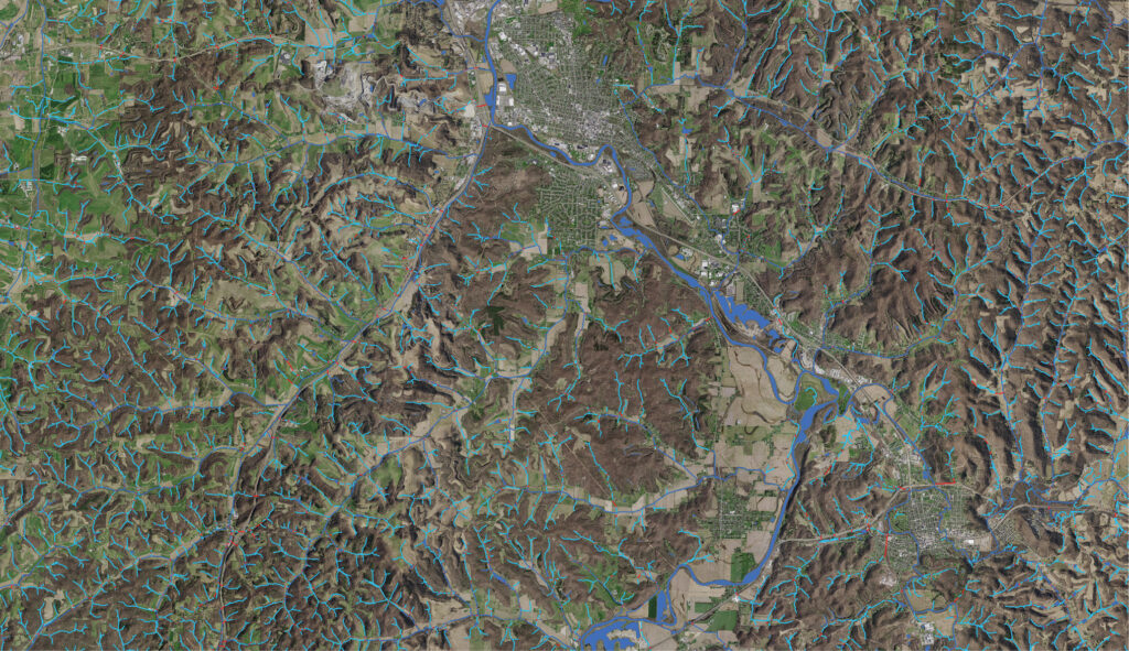
The existing national hydrography dataset. Image courtesy of the Ohio Statewide Imagery Program.
Until recently, Ohio’s existing drainage information came from the National Hydrography Dataset (NHD)1, which outlines rivers, streams, canals, lakes, ponds, and other water bodies to generate comprehensive, national hydrography insights. Within the NHD, Ohio’s data was based on the digitization of surface water features from 1:24,000 U.S. Geological Survey (USGS) topographic maps created as far back as the 1950s. The accuracy and level of detail of these federal maps have been outpaced in recent decades by changing landscapes and advancing mapping and recording technologies. As a result, Ohio’s NHD dataset needed an update.
“Our watershed data was outdated,” said Jeff Linkous, engineer, Clinton County. “It didn’t accurately depict where the true flow of water existed. This was mainly due to changes over time that streams experienced, not only from human development but also from high water and flooding. Our county would benefit from accurate data.”
To provide those benefits, Woolpert developed the Ohio Surface Water Model, an initiative owned and managed by the Ohio Geographically Referenced Information Program (OGRIP), which is overseen by the Ohio Department of Administrative Services (ODAS) Office of Information Technology. The program was designed to replace Ohio’s hydrography data with elevation-derived hydrography (EDH). Currently, 11 Ohio counties have led the way by supporting the replacement of the existing hydrography dataset. Without any financial assistance, the counties funded the updates to the surface water and drainage data for their respective localities, knowing that this would meet critical needs. Their decision to put money towards replacing their data was commended by several state legislators and Ohio organizations such as the County Engineers Association of Ohio, the County Commissioners Association of Ohio, The Nature Conservancy in Ohio, and the Ohio Scenic Rivers Association. With widespread support, Woolpert has continued promoting the creation of EDH data for additional counties. Meanwhile, state agencies and legislators are exploring the best way to expand the effort and partner with the USGS, as was done with the 3D Elevation Program2, a USGS initiative created to deliver high-resolution, three-dimensional elevation data of the U.S.
Leveraging 3DEP and 3DHP
Since 1884, USGS has been mapping the nation, delivering critical topographic and hydrographic insights supporting land management and development across the U.S. As a result of crucial advances in mapping technologies, USGS started gathering high-quality topographic data in 2016 for one of its latest efforts: 3DEP, the first national baseline of consistent, high-resolution topographic elevation data. USGS wanted to derive all new hydrography from 3DEP data. This effort started with developing consistent standards and specifications for EDH, which relies on elevation data from lidar or interferometric synthetic aperture radar to generate vector hydrologic networks.
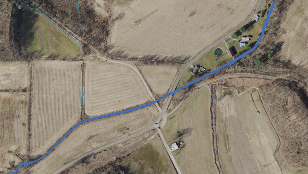
The Ohio Surface Water Model dataset. Image courtesy of the Ohio Statewide Imagery Program.
When Woolpert and OGRIP launched the Ohio Surface Water Model for several counties, it leveraged the elevation data available from 3DEP to provide high-resolution hydrographic data for EDH development. Woolpert also relied on the 3D Hydrography Program (3DHP)3, the USGS initiative designed to “significantly improve the level of detail, currency, and content of hydrography data by deriving 3D stream network datasets and watersheds from the high-quality 3D Elevation Program.” Specifically, the Ohio Surface Water Model includes an EDH network generated from and integrated with 3DEP elevation data that is intended for input into 3DHP to provide data accuracy and the attributes needed to model and analyze Ohio’s surface water and coastline as well as better represent stream gradients, channel conditions, water bodies, hydrologic units, hydrologically enhanced elevation, and other surfaces.
“Surface water bodies are very dynamic,” said Neil Tunison, engineer, Warren County. “They change. They drop sediments, and they’re constantly adjusting course. Having this data [updated] on a fairly regular basis will help us with planning.”
Still, Woolpert and OGRIP wanted to take things a step further. Baseline 3DHP data derived from 3DEP lidar for the continental U.S. represents streams and canals as polygons for features 50 feet and wider and lakes and ponds greater than about ¼ acre. One of the goals of the Ohio Surface Water Model was to ensure the dataset also included ephemeral water when evident on the elevation surface per EDH specifications. Ephemeral water is surface water that flows briefly in direct response to precipitation in the immediate vicinity. Counties, state agencies, and several organizations conveyed their need for Woolpert to collect polygonal data on perennial water for 15-foot or wider streams and rivers, ephemeral flowlines, and lakes and ponds greater than ¼ acre. Once the hydrography was completed for the 11 Ohio counties, contours were generated, which the counties plan to use for a wide range of applications, including preliminary engineering, planning, and economic development. Achieving this would enable Woolpert and OGRIP to capture hydrographic features at a four- to six-times-greater level of drainage detail than is currently available, and core attributes of the hydrography would be identified and defined for all features gathered. However, achieving this with the Ohio Surface Water Model required innovative technologies.
Exceeding expectation demands exceedingly powerful technology
Woolpert used artificial intelligence (AI) and machine learning (ML) to generate the 3DHP data for the Ohio Surface Water Model, followed by manual verification to increase confidence that the information produced was accurate. These technologies assisted in identifying drainage patterns that affect flooding characteristics, stream flows, and water quality. Traditionally, 3D photogrammetric techniques or heads-up digitization from orthoimagery base-mapping was relied upon to compile hydrography data manually. Although time-consuming and laborious (especially when used for large areas), these techniques successfully identified perennial bodies of water for decades. They fell short, however, in their ability to identify ephemeral water bodies and drainage patterns.
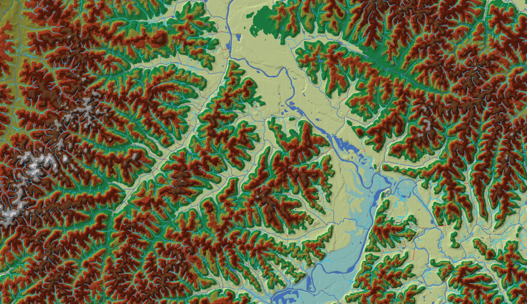
The lidar surface model overlaid with perennial and ephemeral surface water and flowlines. Image courtesy of the Ohio Statewide Imagery Program.
Woolpert needed new technology to gather the desired data as well as new processes to extract hydrography features from the ingested datasets. The new datasets typically included four-band orthoimagery and high-density aerial lidar at a density of eight points per square meter or more. When considering the varied topography across states, counties, and watersheds, no existing manual methods could extract ephemeral drainage effectively or accurately. The solution was AI and ML. Using high-density aerial lidar input consisting of millions or billions of points for a statewide project, AI and ML processes successfully identified ephemeral flowlines as well as small lakes, ponds, rivers, and streams.
The promising features of AI and ML
AI and ML proved to be the best solutions for producing the desired 3DHP enhancements due to their promising capabilities for mapping surface features, especially when coupled with cloud computing. For example, Woolpert used AI to extract features automatically from aerial lidar and determine the flow direction and definition of specific water bodies. Microsoft Azure Machine Learning Studio was instrumental in Woolpert’s effort to develop, deploy, and manage these models effectively and with increased confidence. Additionally, cloud computing enabled Woolpert to store and process the large quantities of remote sensing data essential for mapping large areas. Combined, these technologies improved the precision, efficiency, and scalability of EDH.
Ohio counties ready to benefit
With enhanced EDH ready to be added to Ohio’s portion of the 3DHP dataset, the state is finally positioned to experience much-needed advantages.
This image showcases the high-resolution complement to existing base mapping data. Image courtesy of the Ohio Statewide Imagery Program.
“Clinton County will benefit from accurate data, as it will help with everything, including culvert and bridge modeling, road realignment for safety projects, flood plain review, and soil and water maintenance ditches,” Linkous said. “It will also help us provide the public with current data that assists with planning and economic development proposals.”
Tunison also expressed excitement about the advantages the updated data would provide. He explained that he’s eager to incorporate the information with Warren County’s structural data, “… to get a better handle on the types of bridges and culverts that need to be replaced and how to handle inlets.”
When explaining the infrastructure benefits the updated hydrography will provide, Brett Boothe, engineer, Gallia County, said: “The benefits are very broad. I see opportunities for us to use the data to size our bridges, culverts, catch basins, and any other drainage structures because we’re using better data to make decisions. Also, since the county lies along the Ohio River, one of the issues we contend with is flood plains. We have commercial and residential properties within the flood plain. This data will give us a better opportunity to define where those lines are, which makes a big difference when we’re talking about our county’s economic and residential development. We all know flood-plain insurance is extremely expensive and hinders our growth, so this data will be extremely important from an economic perspective.” 
Brian Stevens is a geospatial program director and vice president at Woolpert. He works out of Woolpert’s office in Columbus, Ohio.