Chung Hsing Surveying Company (CHS) is proud to announce the introduction of RIEGL’s VMX-2HA Mobile Mapping System to the geospatial industry in Taiwan.The company has built an excellent reputation over the past 50 years in the region, and the addition of this RIEGL system enables them to have unprecedented accuracies and efficiencies within their surveying services.

Mr. Lin Dongyu, General Manager of Chung Hsing Surveying Company, said, “We have always been committed to providing the highest quality surveying services, and the introduction of the RIEGL VMX-2HA Mobile Mapping System is part of our pursuit of excellence. In Taiwan, there are densely populated metropolises and complex mountainous roads. The use of this technology will bring more value to our customers, allowing us to meet a variety of survey needs, whether it is road facility surveys, highway slope surveys, urban planning or high-definition maps for autonomous vehicles applications.”
LINKFAST Technology Co., Ltd, RIEGL’s authorized distributor for Taiwan, hosted a demonstration of the RIEGL VMX-2HA in collaboration with RIEGL’s Asia Pacific office. The field operation and post-in-house processing solidified the decision by CHS to invest in this technology. LINKFAST was instrumental in the delivery, installation, system operation, and data processing training that allowed CHS to successfully use the VMX-2HA to execute their projects in a short period of time.
Marcos Garcia, Business Development Manager for RIEGL in Asia Pacific commented, “Mr. Dongyu’s commitment to acquiring the most advanced geospatial technologies in the market shows his lifelong dedication to improving data acquisition in Taiwan. I personally admire this drive which spans several decades since the founding of his company back in 1969. Dean Yang (LINKFAST) and his team have once again proven their high level of skills with some of the most complex RIEGL systems. We are proud to have LINKFAST as partners in Taiwan and will continue our commitment to support all their efforts.”
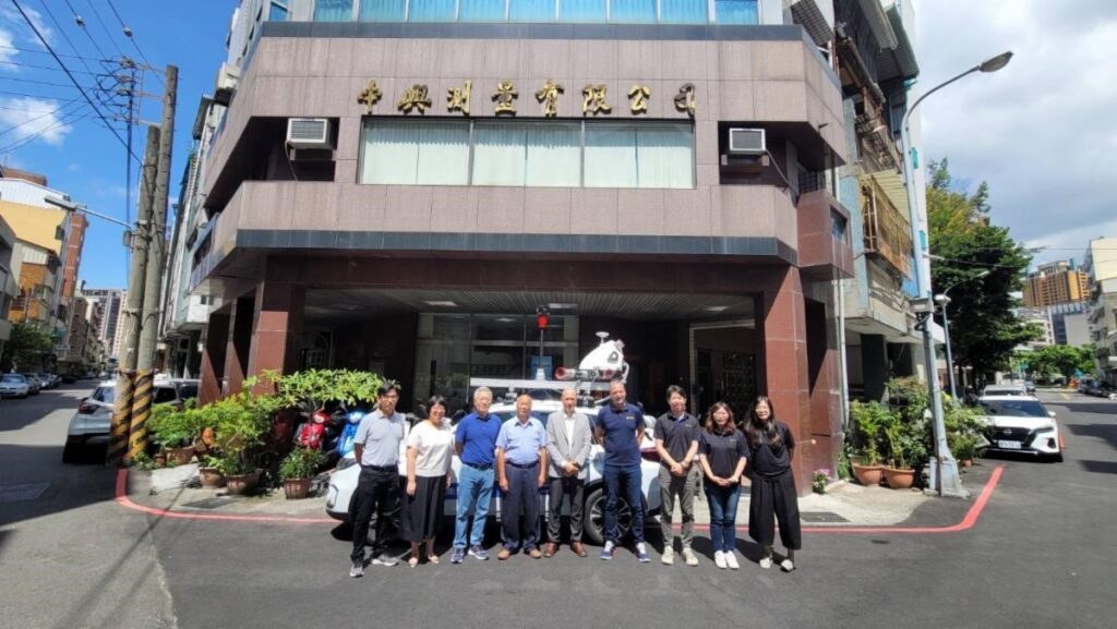
The team of CHS, LINKFAST, and RIEGL during the latest visit to Taiwan.
CHS is excited to include RIEGL’s Mobile Mapping LiDAR technology into its service portfolio to meet the growing needs of the surveying and mapping market and to ensure that clients receive the highest quality data. One of the first projects CHS handled successfully by using the RIEGL VMX-2HA Mobile Mapping system was the collection of slope data for the Directorate General of Highway, MOTC.
Central Cross-Island Highway Slope Safety Investigation, Directorate General of Highway, MOTC
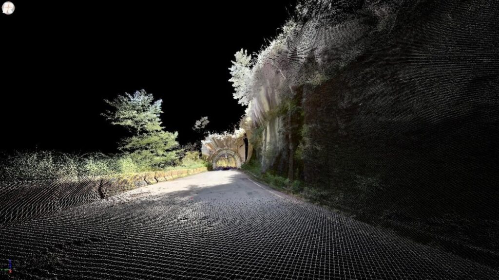
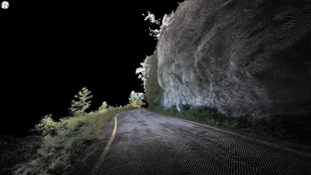
For this project, the main focus was on collecting high-accuracy and informative slope data by mobile mapping. The RIEGL VMX-2HA Mobile Mapping System is well suited for this application, as it acquires more than 1,500 points per square meter, its scanning angle is suitable for slope scanning (especially for steep slopes), and it acquires data from the area that may be obscured when using drone aerial photography.

CHS’s multi-functional surveying and mapping patrol vehicle is based on the RIEGL VMX-2HA system.
The delivered outcrop point cloud with absolute coordinates enables 3D viewing, distance, area, orientation measurements, and slope analysis. Change detection can also be performed by overlaying point cloud data from multiple periods. Further analysis on structural geological, interpreting the altitude of surface of discontinuity, and evaluation on hazard area, such as rock-fall mechanism analysis can also be carried out.
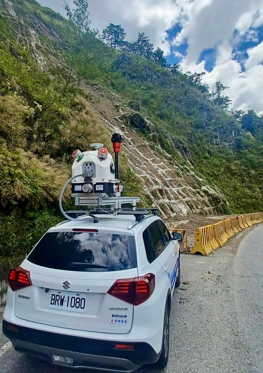
The RIEGL VMX-2HA of CHS performs duties on Taiwan’s most dangerous highway.
With its ultra-high scanning speed, the RIEGL VMX-2HA can quickly pass through dangerous areas while obtaining precise point cloud data.
About the RIEGL VMX-2HA Mobile Mapping System:
This system features high precision, high quality and high-speed scanning capabilities, and is widely used in surveying, mapping, urban planning, traffic management, environmental monitoring and many other fields. The advanced LiDAR technology allows for precise three-dimensional information of the ground and buildings through high-precision LiDAR measurements at extremely high speeds. Thus, customers benefit from faster and more accurate measurement data, saving time and costs.
About Chung Hsing Surveying Co., Ltd:
CHS is a Taiwanese surveying company with great experience and excellent expertise, committed to providing customers with high-quality surveying services. The team is composed of experienced surveying experts and constantly adopts the latest surveying technology to ensure that customers receive the best surveying solutions. CHS’s endeavor is to provide customers with accurate, reliable and efficient surveying data to help them successfully complete various projects. http://www.chsurvey.com.tw/index_en.html
About Linkfast Technology Co., Ltd.:
LINKFAST was founded in 2007 and has represented RIEGL since 2008. LINKFAST is committed to the development of 3D digital technology in Taiwan. For more than ten years, LINKFAST has successfully integrated LiDAR and photogrammetry – two key 3D data – into workflows through software post-processing, and applied them to a variety of industries, including manufacturing, public safety, and aviation, telemetry, navigation maps, construction, and civil engineering, electric power facilities, historical and cultural heritage, forestry and game multimedia, etc. https://www.linkfast.com.tw/
About RIEGL:
RIEGL is an international leading provider of cutting-edge technology in airborne, mobile, terrestrial, industrial and unmanned laser scanning solutions for applications in surveying. RIEGL has been producing LiDAR systems commercially for over 40 years and focuses on pulsed time-of-flight laser radar technology in multiple wavelengths. RIEGL’s core Smart-Waveform technologies provide pure digital LiDAR signal processing, unique methodologies for resolving range ambiguities, multiple targets per laser shots, optimum distribution of measurements, calibrated amplitudes and reflectance estimates, as well as the seamless integration and calibration of systems. RIEGL’s Ultimate LiDAR 3DTM scanners offer a wide array of performance characteristics and serve as a platform for continuing Innovation in 3D for the LiDAR industry. From the first inquiry, to purchase and integration of the system, as well as training and support, RIEGL maintains an outstanding history of reliability and support to their customers. Worldwide sales, training, support and services are delivered from RIEGL’s headquarters in Austria and in the USA; main offices in, Germany, Japan, China, Australia, Canada and the UK; and a worldwide network of representatives. www.rieglusa.com www.riegl.com
