Klau Geomatics continues to break new ground in geospatial technology. The Brumby LiDAR introduces live georeferencing – no post processing.
Nowra, Australia (Feb. 20, 2024) – Klau Geomatics has released the Brumby RTK LiDAR, a mobile mapping system with powerful Edge Compute that generates highly accurate georeferenced point clouds on the fly.
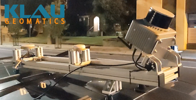
The Brumby can run on drones, light aircraft, or as an MLS, it doesn’t really matter. The thing is, your data is processed to a georeferenced point cloud as it is captured. No post processing. Ready to go straight into your analytics, site assessment, volume measurements, whatever you need to do. No data logjam. Today’s capture, ready to go, now.
See the video of a recent capture here:
The Brumby integrates dual receiver SPAN INS from NovAtel, running NTRIP RTK or Terrastar-C Pro PPP, with custom code to manage coordinate systems and apply precise geoid models to the trajectory. Then, still in real time, the LiDAR raw vectors are projected into millions of accurate RTK survey measurements. The Brumby Edge Compute runs chip-level firmware and highly efficient low-level code on custom hardware to achieve this outstanding outcome.
Unlike SLAM systems, which can claim to create real time data, Brumby data is geo-referenced, so it has real world coordinates.
Why is this important? To enable detection of change over time. Without absolutely accurate geo-referencing, you will have multiple models floating in space. It’s only when the XYZ frameworks are the same that you can then look at the effect of ‘T’, time. Are the potholes still there in the road? How much material has been added or subtracted from the mine site?
And change over time is more valuable when it addresses the situation now. Today’s volumes are more critical than last week’s. The precise location of assets on a military battleground – essential now.
Brumbies can be built with Hesai, Ouster, Livox, Velodyne or Riegl scanners. The current model, with the Hesai XT32M2X scanner, generates clean accurate data at ranges up to 200m (depending on reflectance). This is well suited to mobile laser scanning from a vehicle, or airborne from a drone or helicopter. The price point of the Brumby as an MLS makes land based scanning a highly efficient option.
“The LiDAR industry is currently like surveying was ‘pre-RTK’. For those of you who can remember surveying before RTK (a bit like asking if you remember a world before the internet), you’ll understand where I’m coming from. This is all about to change,” says Rob Klau, Director of Klau Geomatics.

About Klau Geomatics
With its heritage in geodetic surveying and mapping, Klau Geomatics has been building creative geospatial hardware and software systems for over a decade, including the industry leading KlauPPK system for aerial mapping, MakeItAccurate processing service, manned aircraft pods and FMS, and LiDAR innovations such as Stockpiler and Brumby. For more information visit geomatics.com.au
