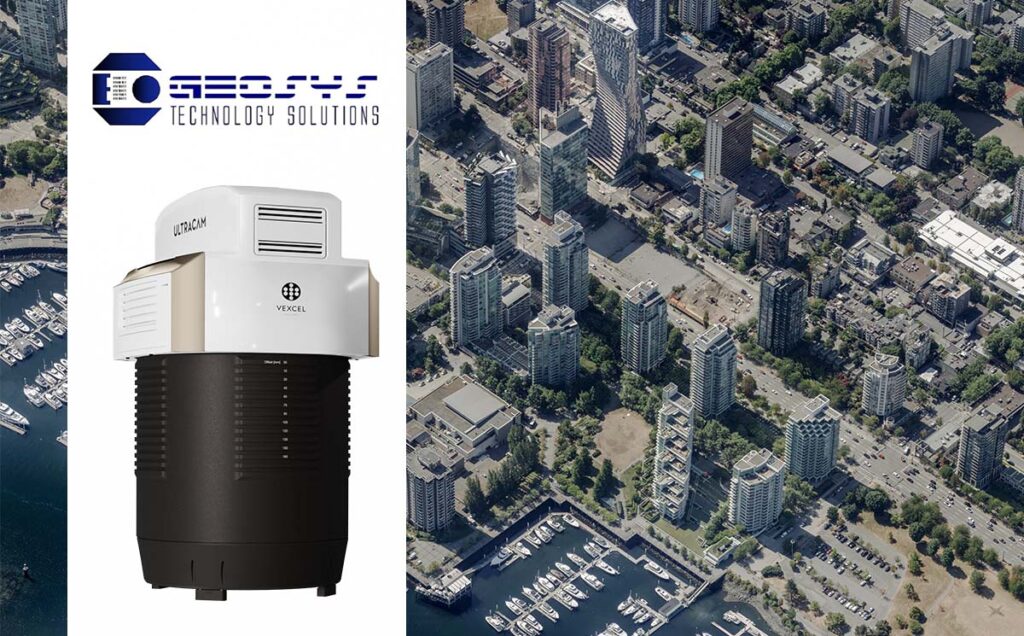
Denver, Colorado, USA • February 13, 2024: From the exhibition hall at the 2024 Geoweek conference, Vexcel Imaging, a global leader in aerial imaging solutions, announces the acquisition of two state-of-the-art UltraCam Eagle 4.1 aerial sensor systems by GEOSYS Technology Solutions, Ltd. headquartered in Vancouver, British Columbia in Canada. This significant acquisition underscores GEOSYS’ commitment to advancing their aerial imaging capabilities and solidifies their position as a premier provider of geospatial solutions in Canada.
GEOSYS will deploy the UltraCam Eagle 4.1 systems through its subsidiary companies, The Airborne Sensing Corporation based out of Toronto, Ontario; and Geodesy Group Inc. based out of Calgary, Alberta. With this purchase, GEOSYS becomes the sole operator of UltraCam Eagle 4.1 systems in Canada, further enhancing the company’s ability to deliver cutting-edge aerial imaging services to their clients across various industries.
“We are excited to partner with GEOSYS and to support their mission of delivering exceptional aerial imaging solutions,” said Alexander Wiechert, CEO of Vexcel Imaging. “The acquisition of not just one but two UltraCam Eagle 4.1 systems greatly underscores GEOSYS Team’ commitment to excellence and innovation in the geospatial industry.”
The UltraCam Eagle 4.1 is Vexcel’s flagship product in its Premium line of camera systems, which are defined by the inclusion of a panchromatic channel for the utmost in geometric and radiometric accuracy that is required to produce photogrammetric-grade data. UltraCam Premium systems are renowned for exceptional image quality, precision, and reliability, making them the systems of choice for demanding aerial mapping and surveying projects. The UltraCam Eagle 4.1 features all the technological advancements introduced with the UltraCam 4th generation architecture and as such is highly efficient and cost effective to operate while producing aerial data that is of the highest detail, clarity and accuracy. The system is compatible with Vexcel Imaging’s novel and proprietary Adaptive Motion Compensation (AMC) software technology that corrects multi-directional motion blur, mitigating time-consuming and costly reflights. GEOSYS data clients will also benefit from Vexcel’s proprietary True Pixel Processing (TPP) software approach for preserving all pixel information from initial exposure to final data products, reducing noise in bright and shaded areas while retaining fine details for maximum information retention.
“Vexcel technology has been integral to our success since 2005, marked by the introduction of the first UltraCam digital camera into our production. In our persistent pursuit of excellence, we strategically opted to once again leverage Vexcel technology for our camera system upgrade. This decision aligns with our commitment to providing clients with the best geospatial solutions available in the market today,” stated Babak Ameri, CEO, and President of GEOSYS companies. “With Vexcel’s cutting-edge technology and exceptional support system, we are confident in delivering unparalleled quality and innovation in our service offerings. Our journey with Vexcel continues, a path forward towards geospatial advancements.”
About Vexcel Imaging
Vexcel Imaging, a leader in aerial imaging solutions, provides cutting-edge camera systems, mapping tools, and photogrammetric software to support a wide range of geospatial applications. With a focus on innovation and excellence, Vexcel Imaging empowers customers worldwide to capture, analyze, and visualize their environment with unparalleled precision and accuracy.
About GEOSYS Technology Solutions
GEOSYS is a leading provider of geospatial technology solutions, offering innovative products and services to clients across various industries. With a focus on delivering high-quality aerial imaging and geospatial data, GEOSYS helps organizations make informed decisions and gain valuable insights into their operations.
