In the historical era of expeditions, simply reaching the unknown and dangerous destination was usually one of the biggest challenges. Scientific research was carried out, but exploration was perhaps the premier motivation. Today’s expeditions are usually very focused on science. Though transportation has become much easier, the challenge of delivering top scientific results in the high arctic requires the right people, training and attitude. This account of mosquitos, muskox encounters and an emergency solution for the camp freshwater highlights the fact that expeditions are still adventures that require resilience and improvisation.
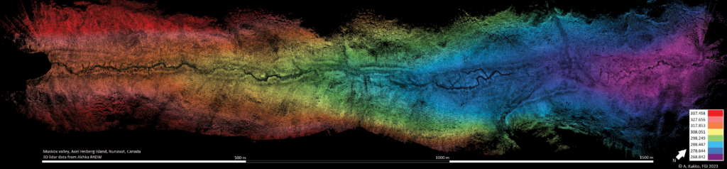
Elevation model of Muskox Valley based on the expedition’s lidar data. The glacial lake is located to the left of the image, and the glacier front is further to the south-west, beyond the left of the image. The valley continues to the north-east to join a river further down. The muskox encounter took place at the edge of the image to the right.
Journey begins
In 2019 I was offered an opportunity to join a Canadian-US team for field work in the archipelago of the Canadian high arctic. I had been in that Inuit territory in 2016 and 2017 on Devon Island, the largest uninhabited island on Earth, studying land formations in and around the Haughton impact structure and close to the ice cap in the east of the island. This time I was able to venture further north, to Axel Heiberg island in Qikiqtani region, Nunavut.
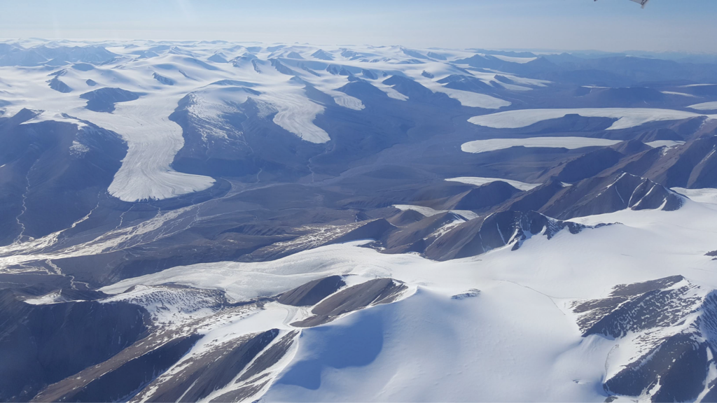
Glaciated landscape of southern Axel Heiberg island.
In 2014 I had been contacted by a laser-scanner distributor with a request to rent an instrument for a US-based planetary researcher. We made an agreement to lend them one of our terrestrial laser scanners, on condition that we could join the team for a field study in Saaremaa, Estonia to scan the Kaali meteorite impact structure with a backpack scanner we had developed just a year earlier. This collaboration with Mike Zanetti (now NASA) brought me in contact with the planetary research team from the Institute for Earth and Space Exploration, University of Western Ontario, Canada, and later with scientists from University of British Columbia, Arizona State University and Simon Fraser University.
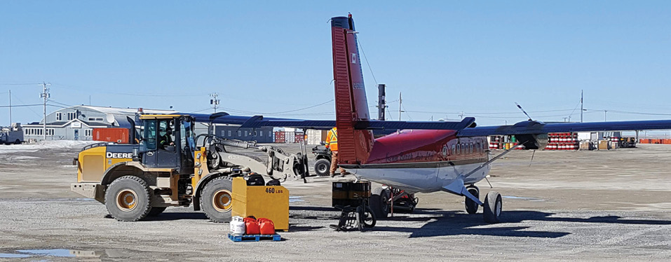
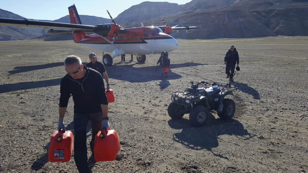
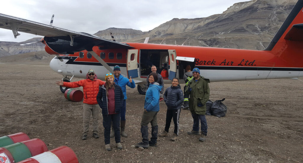
Twin Otter (Ken Borek Air Ltd.) being loaded at Resolute Bay airfield to airlift us to the expedition.
At the end of June 2019, after months of planning and numerous remote meetings, I flew from Helsinki to Ottawa, where I met the rest of the team. The flight route from there took us to Iqaluit, then on a turboprop via settlements in Clyde River, Pond Inlet, Arctic Bay all the way to Resolute on Cornwallis Island, where the Polar Continental Shelf Program (PCSP) of Natural Resources Canada runs a base to support logistics for research and other activities.
Camp in sight! The first half of the team got the camp going prior to our arrival. Large polygon formations prominent to permafrost terrain are seen across the river plain. White traces reminiscent of snow on the ground are salt.
PCSP base provides research teams with accommodation, catering services and logistical support to reach remote camps and study sites all across the vast span of Arctic desert islands. In the storage hall, each team doing long-term research in the region has its own cage room to store camping and field gear and desiccated food supplies. Fresh food was freighted for the season and collected from the PCSP storage along with ATVs for transportation, gasoline and generators for electricity, and natural gas stoves. Bear bangers, whistles, guns and briefings to be ready for possible encounters with polar bears were also necessary, completed with training with live rounds at the camp on the first evening on Axel Heiberg island.
Arrival at Axel Heiberg island
It took two flights of the Twin Otter to move the team and equipment to Axel Heiberg island. The 550 km flight crossed glaciated mountains, retracting ice lobes in valleys, and arctic desert landscape.
Unloading cargo from the plane. These small ATVs provide a handy means of travel—usually we could do day trips 25-30 km away from the camp. Climbing twice to the 450 m high plateaus seen in the background to reach study sites with all the laser equipment, water and food for a day, carrying out several hours of scanning and hiking back to the camp was memorable!
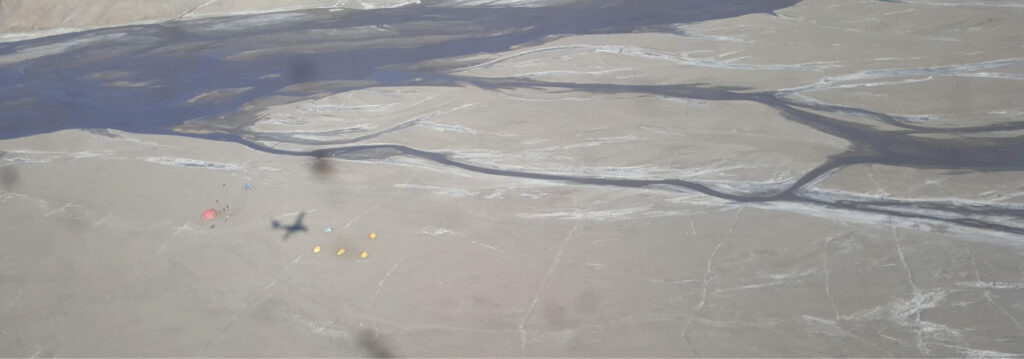
The plane circled around the sunlit camp set on a meltwater river plain and landed to the west. We stopped next to the space dome, our living room for the next couple of weeks. We unloaded the gear, the plane accelerated across the makeshift airfield, took off and we were alone in the middle of nowhere.
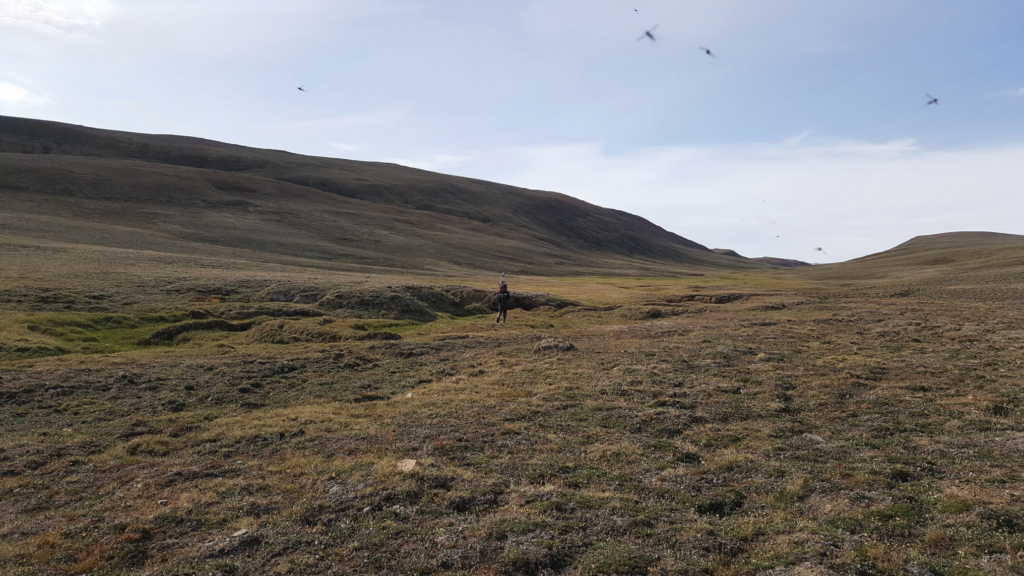
The Muskox Valley was a spectacular, serene sight despite the millions of mosquitoes. The low U-shape of the valley is very clear. There were green pastures at the bottom of the valley – the living room of the muskox. Lidar mapping was carried out meticulously following the troughs and other terrain features to capture the valley topography.
After improvizing with a bucket and cloth after the camp’s water filter had become clogged by river mud, we settled into daily life. The morning routine included scheduled radio communication checks with PCSP. Satellite phones were available and useful when the team was split between various, often very distant field sites to check status, and inform travel routes and rendezvous, coordination that was especially critical on days when we had helicopter transport. Electricity was provided by a small 2 kW generator to charge the batteries of computers, GNSS devices and science equipment.
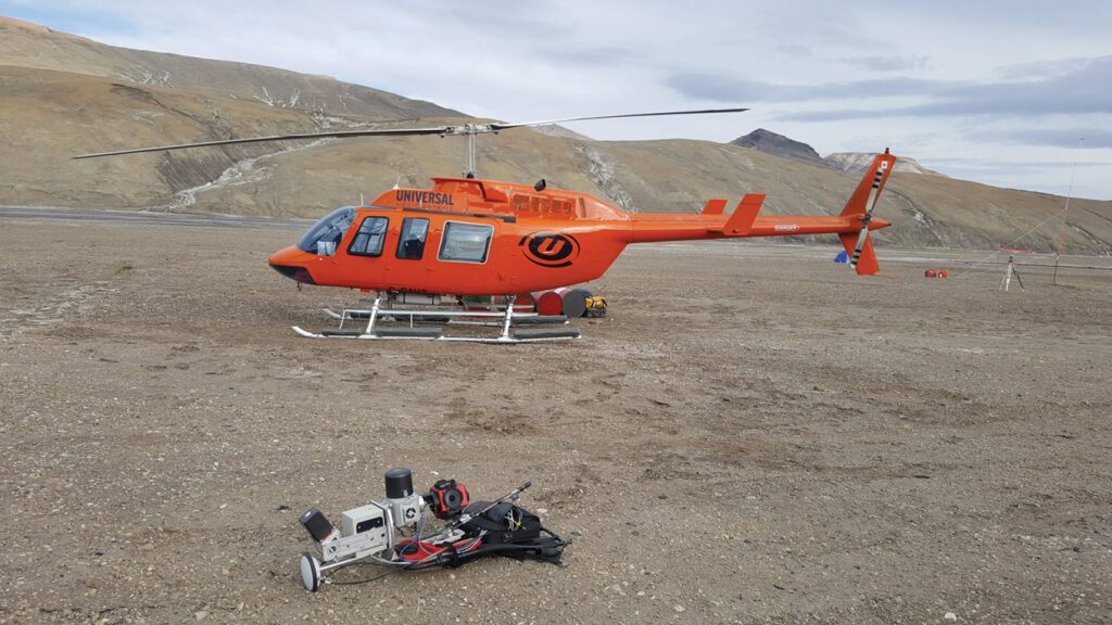
Sites beyond a hike, climb or ATV ride were reached with a helicopter operated by Universal Helicopters (this business no longer exists). We had four helicopter days during the campaign, so the site visits were carefully selected and prioritized. On the ground at the front lies the Akhka-R4 lidar backpack that was used for mobile laser scanning of the permafrost and periglacial landforms on various sites on Axel Heiberg island. To the right is the GNSS base station used for correcting the lidar positioning data, the camp generator and radio mast are visible too.
After a day in the field there was backing up, data processing and and completing field notes. The sun was up all night long, so the long days gave ample opportunity for work tempered by sleeplessness.
Trip to Muskox Valley
On the expedition’s sixth day, three team members made a trip to a then unnamed glacial valley, expected from satellite imagery to be interesting for studying subglacial channel morphology and hydrology. The plan was for the helicopter to drop us off for other duties. The site was located about 60 km north of the camp, so the short flight saved considerable effort crossing multiple rivers and rugged terrain on ATVs.
Snaking the terrain to capture the details. The backpack’s mobile lidar trajectory is shown in green on top of the reflectance-colored terrain data.
We circled briefly around above the valley for photography and reconnaissance of the site before landing on a selected spot which was to become the lower end of the scanning work with the backpack lidar. The topmost point would eventually be about 2 km distance up the valley by a small glacial lake. The site occurs within a recently deglaciated valley on the eastern side of the island and lies a few kilometers to the southeast of a prominent ice lobe extending from the Müller Ice Cap (79° 54 ‘44.4”N, 89° 10’ 37.1”W). The full valley is 8 km long and 1 km wide, and has a flattened U-shape, typical for a formation of subglacial origin. The eastern Axel Heiberg region has a polar desert climate with an annual mean air temperature of -19°C. During our expedition, however, we experienced 15-20°C day temperatures, compared to the July average of 6°C for the past 40 years.
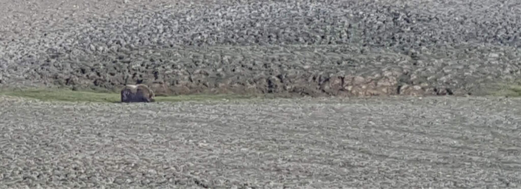
The owner of Muskox Valley grazing in its natural habitat. The slopes of the valley provide very little fresh fodder in mid-July.
We could feel the fresh breeze with a smell of the glacier a few kilometers to the west. The valley was covered with tundra vegetation, small white flowers blooming all over, low grass looking burnt dry higher on the valley slopes, but lush at the bottom and in the polygon troughs where traces of streaming water and small bonds could be found.
We waved the helicopter off, and set up for the scanning and site survey. A team member volunteered for the first try-out of the backpack scanning, so I gave him an introduction on how to paint the scene with my lidar brush, and soon he started snaking up the valley from side to side and contouring the trough formations to capture the terrain topography of the valley. Another member started photographing and making a survey of the valley sediments, hydrology and landforms. I was bear watchperson and explored the terrain—especially intriguing was a landslide lobe protruding into the valley from the southern slope.
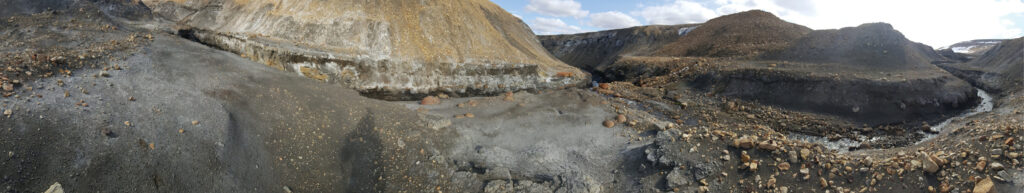
Concretions. Meltwater erodes sharp channels through the landscape. I came to this location down from the glacier along the channel to the right.
We switched tasks when we changed batteries and we were privileged to see a muskox standing near a small crest on the southern slope where the valley narrowed. The animal was curious, but not delighted that humans had invaded its home, so we kept our distance and no incident occurred. We decided to give the beast space, headed from its location up to the shore of a small oblong glacial lake and set the instrument down for a break. We started to scan the very prominent troughs at this location, following the channel back down the valley. We pondered the marks of a lake outburst and relatively recent lowering of the lake surface. We completed the scanning of the middle portion and the upper slopes of the area in the valley.
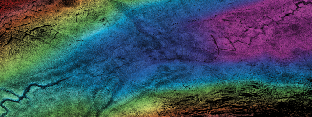
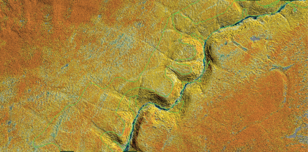
A detail of the 2 cm resolution elevation model of the Muskox Valley floor with polygon-controlled channeling and a landslide lobe. This image covers ~500 m from left to right and north is up.
As a result of the scanning we could reconstruct the topography of the site, now dubbed as Muskox Valley. Back home the lidar data was processed into a very high-resolution digital terrain model with 2 cm resolution. This permitted computational analysis of the properties that characterized the valley morphology, channelization and hydrodynamics, and for assessing erosion and sediment transport in the event of a glacial lake outburst. Based on this model and field study we could perform scientific analysis and simulations. The findings have been published1.
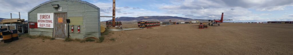
Eureka International Airfield offers all the basics a frequent flyer needs.
The current expression of surface channels along Muskox Valley is diverse, depending on the presence or absence of polygons. The high-resolution lidar model shows that the character and extent of erosional channel incision is spatially discontinuous along the valley. Whereas well-developed channels are common around the edges of large polygons and within inter-connected troughs, channelization is diffuse or non-existent where relatively poorly developed polygons occur in wetlands. Polygon geometry seems to be able to influence, even govern the channel path both across and down topographic gradients at the valley.
Wrapping up the expedition
During the two weeks I performed scans towards the expedition goals at multiple locations near the camp, up on the plateaus west of camp and even at a couple of locations in the vicinity of Strand Fjord on the west side of the island. Some of the scans were quite extensive, such as subglacial valleys and a thaw slump that took multiple hours of mapping, and some more localized patterned ground features. For one study we scanned a large section of polygon formation on the southern slope of the Strand Fjord at its east end. The most peculiar place was the so-called brain terrain formation about 30 km north-east of camp. Brain terrain is an extraterrestrial feature seen extensively on the surface of Mars, but the location seems to have an analog here on Earth. Two team members also carried out ground-penetrating radar surveys to reveal ice wedges and other structures beneath. One day I scanned a narrow glacial meltwater channel eroded through the permafrost ground and ice. The channel opened up to a larger stream and rapidly rushing waters, where erosion had exposed many concretions of various sizes, the largest of which I saw was about 1 m in diameter.
Time for farewell in good spirits.
Like the trip to the site, the return required two flights. After the departure of the first plane out, a smaller group was yet able to do more fieldwork and data backups, finalizing fieldnotes, data processing and other tasks.
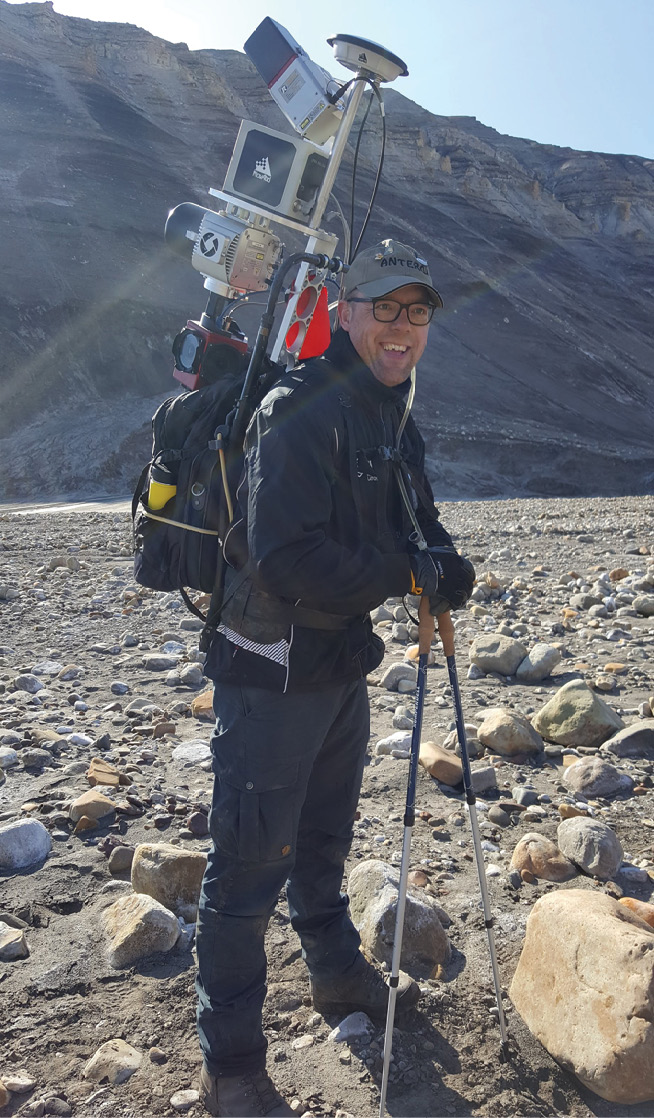
The author on a hike to a plateau on Axel Heiberg island in July 2019. His Akhka-R4 backpack lidar system provides an efficient survey tool to map terrain topography at high resolution.
On our way out (from Axel Heiberg) we flew via Eureka International Airfield, which is the northernmost settlement I have visited thus far on my journeys. We stopped there to refuel the airplane and had a brief vision on the station. And thus ended a memorable lidar expedition. 
1 Chartrand, S.M., A.M. Jellenek, A. Kukko, A.G. Galofre, G.R. Osinski and S. Hibbard, 2023. High arctic channel incision modulated by climate change and the emergence of polygonal ground, Nature Communications, 14, 5297. https://doi.org/10.1038/s41467-023-40795-9.
Nomenclature
Polygon ground: the distinct and often symmetrical natural pattern of geometric shapes formed by the deformation of ground material in periglacial regions. Polygons can form either in permafrost areas (as ice wedges) or in areas that are affected by seasonal frost.
Brain terrain: a feature of the Martian surface, consisting of complex ridges found on lobate debris aprons, lineated valley fill and concentric crater fill. It is so named because it suggests the ridges on the surface of the human brain.
Concretion: a hard, compact mass formed by the precipitation of mineral cement within the spaces between particles, and is found in sedimentary rock or soil. Concretions are often spherical in shape [source: Wikipedia].