Following three, dedicated years of pioneering inertial measurement unit (IMU) development, we are delighted to introduce you to the RT3000 v4 GNSS/INS.
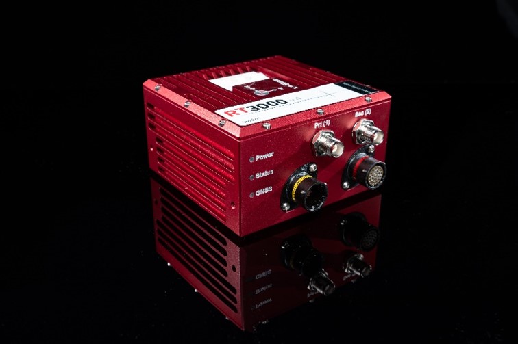
Combining our most advanced, MEMS-based IMU technology with survey-grade GNSS receivers, the RT3000 v4 builds on its predecessors reputation as the commercially-viable GNSS/INS for FOG-like navigation performance – delivering accurate position, orientation and dynamics data in even more places, even more of the time.
Position – 0.01 m
Heading – 0.04°
Pitch/Roll – 0.01°
Velocity – 0.025 km/h
Read the datasheet to learn more – RT3000 v4 Datasheet
Why choose the RT3000 v4?
Our highest performing INS yet – Combining two survey-grade GNSS receivers with OxTS’ latest IMU10 inertial technology, the RT3000 v4 delivers uninterrupted position, orientation and dynamics in all environments.
Position –
Heading –
Pitch/Roll –
Velocity –
ITAR-free – No need to deal with costly and cumbersome export controls. Ship your RT3000 v4 globally without the need for export licences.
Low dynamics warm up – The RT3000 v4 will get to specification within three minutes of low dynamics movement so you don’t need lots of time and space for high dynamics manoeuvres before each data collection.
Post-processing tools included – Avoid the hassle of software subscriptions with OxTS software suite, NAVsuite, included free-of-charge for as many users as you need.
Compatible with both OxTS Georeferencer and OxTS LIO – Using LiDAR? Take the data from your RT3000 v4 and use it to create clear and concise pointclouds with OxTS Georeferencer, and if you’re conducting vehicle testing in urban canyons, why not use OxTS LiDAR Inertial Odometry to combat the effects of position drift in difficult GNSS conditions?
RT3000 v4 Datasheet
The RT3000 v4 datasheet contains all of the information you need to determine whether our latest INS technology is right for your next project.
With a range of optional features and software integrations, RT3000 v4 users have the flexibility to mould their device into the ideal INS for their particular project. Whether this is on the proving ground, in difficult GNSS conditions OR for LiDAR survey and mapping use cases, the RT3000 v4 has something for you.
The RT3000 v4 datasheet details all of this and more – RT3000 v4 Datasheet
Further Reading…
Open-road vehicle testing solution brief
GNSS signal dropout can make it challenging for test engineers and surveyors to collect data in urban environments. Packed full of features to help increase the amount of time spent with usable data, the RT3000 v4 can help.

Read the solution brief to learn how you can use the RT3000 v4 to take open-road data collection to new heights.
Land-based LiDAR mapping solution brief
OxTS INS devices are used by LiDAR surveyors across the world to ensure that the pointclouds they create are accurate and free from sensor misalignment errors. The measurements produced by the RT3000 v4 allows your LiDAR sensor to know when and where it is – two crucial factors when creating digital replicas of an environment.
Read the solution brief to learn how you can use the RT3000 v4 to create accurate, georeferenced pointclouds.
Webinar
Watch the webinar, originally broadcast on January 8th 2024, to find out:
+ The performance you can expect from the RT3000 v4, particularly in challenging GNSS conditions.
+ The usability improvements that you can benefit from.
+ How you can be among the first to try one.
