Exwayz, pioneer in reliable 3D positioning and navigation software, today unveils Exwayz 3D Mapping, its all-in-one software capable of creating city-scale 3D point clouds of outdoor areas in world coordinates. Plug and play and versatile, this powerful software can work with any LiDAR and GNSS system of the market and creates centimeter-accurate georeferenced maps of cities, industrial sites, ports and any other outdoor areas. It achieves unseen robustness and precision levels to the nearest centimeter through cutting-edge innovations in optimization and 3D vision. Welcome to the era of limitless 3D mapping superpowers!
- Addresses the technical challenge of 3D mapping with partially unreliable GNSS data
- Local accuracy : up to 2cm
- Global accuracy : up to 2cm
- Available as a software suite with CLI and GUI for seamless integration
- Already trusted by leading integrators of 3D mapping systems
One hundred million: this is the number of autonomous mobile robots that the industry will need by 2030[1] every year, whether it is for delivery, autonomous transportation but also logistic handling and industrial inspection. The first challenge to overcome is to provide the robot with its accurate position, critical for its autonomous navigation in the operating environment, which thus needs to be precisely mapped to give the system a reliable reference.
Exwayz 3D Mapping (3DM) can process the raw data of any LiDAR sensor and fuse it with Global Navigation Satellite System (GNSS) data for creating centimeter-accurate 3D maps of wide environments such as cities or industrial areas. It’s the only pathfinder autonomous robots need to become truly autonomous, wherever they are!
Exwayz 3DM: Finally, a software that bridges the gap between LiDARs and GNSS The convergence of Global Navigation Satellite System (GNSS) reference technology and the recent affordability of LiDAR sensors has opened new doors for high-precision mapping at an affordable cost.
Exwayz has identified a critical challenge in leveraging these two technologies : the absence of a seamless integration between LiDAR and GNSS, hindering the creation of dense 3D point clouds. GNSS alone faces limitations in accuracy and reliability when confronted with obstructed skies or enclosed spaces, while LiDAR itself doesn’t measure its own position and motion, which is critical for creating maps with the data it collects. Traditionally, the integration of an Inertial Measurement Unit (IMU) is needed, but it can incur high costs and complexities, while not solving all the challenges of 3D mapping.
Enter Exwayz 3D Mapping (Exwayz 3DM) – a game-changing innovation that bridges this technological gap with no additional hardware cost. By harnessing raw data from LiDAR and GNSS sources in post processing, Exwayz 3DM employs cutting-edge algorithms to automatically generate 1cm precise point clouds, both locally and globally. Moreover, as an agnostic solution, this groundbreaking software seamlessly integrates GNSS and LiDAR of any brand, effectively overcoming the limitations previously encountered in creating accurate 3D point clouds.
Infinite use cases for all operating mobile robots
The integration of LiDAR and GNSS into robotics systems has become the norm. To meet the evolving demands of today’s automation landscape, Exwayz equips robotics systems with advanced capabilities by providing a comprehensive 3D map of the operational zone and accompanying navigation software, enabling real-time LiDAR-based positioning.

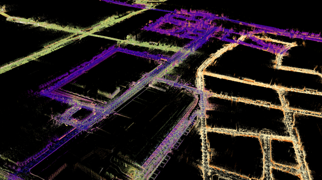
Birdview of an autonomous delivery robot being localized in a city-scale map (purple-ish) created with Exwayz 3DM in the neighborhood of La Defense (Paris) using Exwayz LiDAR navigation. In white, the LiDAR frame that the robot “sees”, used by Exwayz solution to localize the robot in the map.
Highly versatile and efficient, its 3D mapping software finds applications across a wide spectrum of industries and use cases. From the autonomous transport of swap bodies within logistic centers to the optimization of last-mile delivery systems, Exwayz’s technology is a reliable and evolving solution in various ever changing environments where the mapping itself is the first challenge to overcome. It can also enhance the efficiency of autonomous shuttles and the positioning accuracy for autonomous trains. Exwayz’s city-scale mapping capability can revolutionize transportation systems globally!
According to Hassan Bouchiba, CEO of Exwayz, “Exwayz is committed to revolutionizing the robotics landscape by providing state-of-the-art 3D mapping and navigation solutions. Our technology serves as a catalyst, empowering robotics systems across various industries, ensuring precise positioning and unlocking new realms of efficiency and automation.”
How it works: a pipeline to unlock all the limitations of current mapping solution
In large scale mapping, one major difficulty is achieving globally consistent point clouds when visiting multiple times the same area in the same mapping run, which is commonly known as handling loop closure events. Moreover, inertial-based mapping systems are limited for ensuring accurate georeferencing while maintaining centimeter-level precision in point cloud creation. Thanks to its unique approach, Exwayz 3DM encompasses all the essential software solutions required.
“Our software utilizes directly the LiDAR data to generate crystal sharp point clouds, and integrates external GNSS information to ensure global accuracy, without breaking local consistency thanks to our innovative optimization framework” says Mathias Corsia, CTO of Exwayz. “The software inherently produces flawlessly detailed point clouds devoid of local discrepancies.”
Multi-session SLAM, an unprecedented feature to create and update city-scale maps
Another Exwayz 3DM feature that sets a new standard in the field of mapping technology is the multi-session SLAM (Simultaneous Localization and Mapping) functionality. It enables the seamless fusion of multiple maps derived from diverse data collection sessions. This unique ability to consistently merge data obtained across varying timeframes, spanning months or even years, makes it an ideal solution for comprehensive map maintenance, expansion, and large-scale mapping applications. By offering this innovative approach, Exwayz 3DM revolutionizes map creation, providing unparalleled flexibility and accuracy in mapping vast urban landscapes.
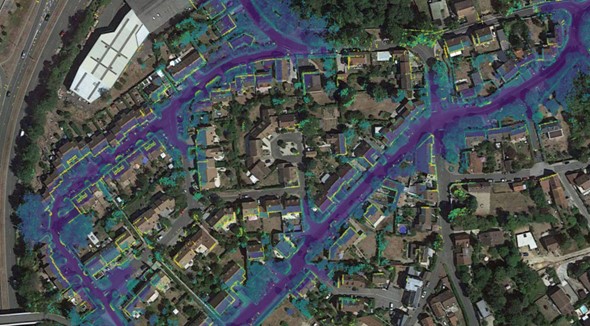
Example of city-scale map made with Exwayz 3D mapping and the multi-session feature : the yellow map is dated from September 2022, while the purple one was made in November 2022 and the green one 6 months later, in may 2023. The multi-session SLAM detects the redundant zone in each map and stitches them exactly from creating a single, locally and globally consistent map
Come meet Exwayz at CES LVCC : West Hall (Business France booth 5400)
About Exwayz
Exwayz is a French startup founded in 2021 by Hassan Bouchiba (CEO), Mathias Corsia (CTO) and Antoine Plat (COO), offering a groundbreaking solution for autonomous navigation within complex and dynamic industrial environments. Exwayz SLAM technology is built upon proprietary innovations in computer science and 3D vision. It is the first reliable embedded software solution capable of achieving centimeter-precise positioning for mobile robots through real-time 3D LiDAR data processing. Exwayz embedded software finds applications in various fields, including self-driving trucks, autonomous vehicles, inspection, and delivery robots. It has already been successfully deployed in numerous industrial and logistics scenarios, accumulating over a thousand hours of operation.
[1] Sources : Internal estimates and Facts & Factor 2021, Global Data 2021, Allied Market Research 2021
