As an industry leader in mobile mapping solutions, Trimble Applanix is well known for its pioneering advances in the GNSS/inertial space for land, air and sea-based applications for a wide variety of industries. In the past year, the company has introduced several interesting and novel advances, including a high-accuracy navigation package and a lidar-based georeferencing optimization solution. Both innovations were put to work on a project in China with impressive results.
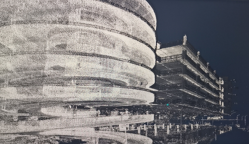
Multi-story parking garage above underground parking.
Inside AVP mapping
NavInfo, China’s leading location service and smart mobility solution provider, was tasked with mapping a large underground parking lot with roughly 1000 parking spaces. The resulting data will be used for automated valet parking (AVP), a sensor-based solution that automatically drives a car to a parking spot and then returns to a designated pickup point when authorized. Due to the tight space in the underground parking, the AVP is currently limited to vehicles equipped with autonomous driving capabilities.
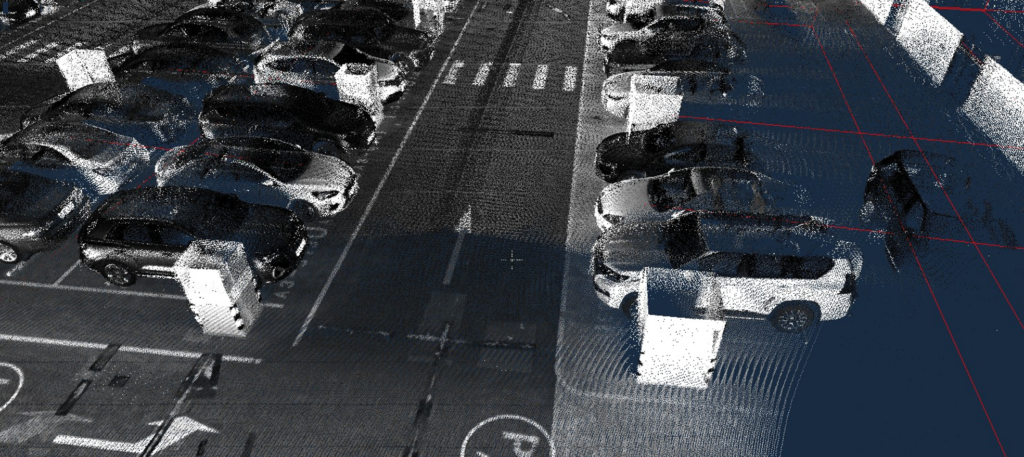
Inside underground parking garage.
The company has become a leader in the fields of navigation maps, dynamic traffic information, and customized connected vehicle solutions for passenger cars and commercial vehicles. NavInfo has relied on a variety of Trimble Applanix hardware products acquired through LEN, the Applanix representative in Mainland China, since 2017.
Guo Linxi, process development engineer for research and development at NavInfo, said, “Applanix products are high-accuracy with reliable performance, and the latest AP+ product line continues the product excellence.”
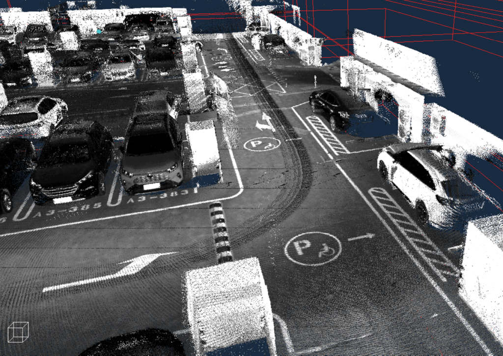
Corner of underground parking garage.
Applanix hardware solutions are used by NavInfo’s autonomous driving group, HD MAP, and many other departments. “Other companies can only provide relevant data-processing software or POS hardware separately, while Trimble Applanix provides a complete solution including hardware and software. Therefore, the Trimble Applanix product is definitely our first choice,” added Linxi.
To be effective for AVP purposes, the underground parking garage map requires high accuracy to ensure that cars are parked with precision—in this case, point-cloud accuracy to within 10 cm. NavInfo opted for the Trimble AP+ 60 Land GNSS-inertial OEM system and the Applanix LiDAR QC Tools, a georeferencing cloud and trajectory adjustment software.
The Trimble AP+ 60 Land is a next-generation, embedded GNSS-inertial solution. What makes it particularly valuable for NavInfo’s underground garage project is that it is small enough to easily integrate into most compact mobile mapping systems, and is configurable to meet the mapping, positioning and direct georeferencing accuracy demands of mapping and positioning applications in environments that are challenging for GNSS signals.
Besides its survey-grade GNSS/IMU sensors and distance measurement indicator (DMI), the Trimble AP+ 60 Land incorporates the all-new Applanix IN-Fusion+™ GNSS-aided inertial firmware featuring Trimble ProPoint™ GNSS, a GNSS measurement processing and correction methodology.
Anna Jarvis, product manager for land mobile mapping at Trimble Applanix, said, “This integrated GNSS/inertial navigation technology provides the highest level of navigation sensor integration, producing position and orientation measurements with an unequaled level of accuracy and robustness.”
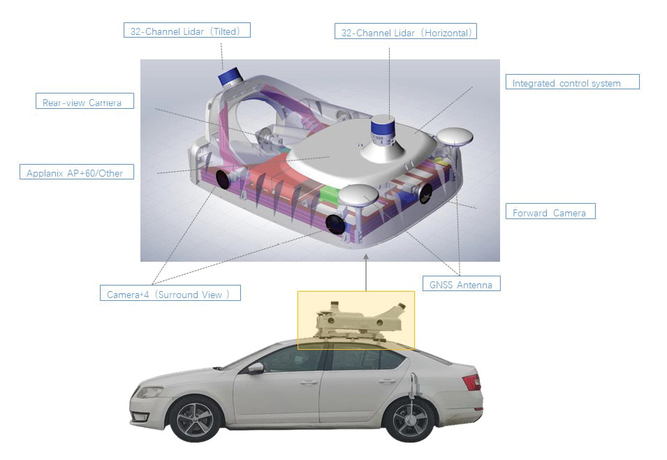
HD MAP data acquisition system: Type L. NavInfo mobile mapping vehicle.
At the heart of the Applanix IN-Fusion+ technology is an advanced Kalman-filter architecture that incorporates sophisticated inertial and aiding sensor error models developed using the Applanix SmartCal technology and Trimble ProPoint GNSS.
In the case of the underground garage, data from inertial sensors is run through a navigation algorithm and fused with information from other sensors such as GNSS and the DMI to produce highly accurate, high-rate 3D measurements of the position, velocity, and orientation of a platform as it moves.
“It is an optimal method of blending the information of all measurement systems into a single solution,” Jarvis continued. “In essence, this advanced technology takes advantage of each measurement technology and eliminates or significantly reduces individual limitations.”
In addition, Trimble ProPoint GNSS leverages the latest developments in GNSS signal infrastructure and Trimble’s high-precision Maxwell 7 receiver hardware to deliver improved positioning performance in challenging environments. It enables robust GNSS positioning performance under harsh tracking conditions, while its sophisticated signal filtering and error modeling means better protection against jamming, spoofing, and multipath interference.
For the underground parking garage mapping project, LiDAR QC Tools provide the final calibration and drift correction to the point cloud data.
QC connections
While LiDAR QC Tools have been available for the Trimble Indoor Mobile Mapping Solution (TIMMS) for many years, the same capabilities have only recently become available for airborne and land applications to optimize positioning accuracy in areas where GNSS coverage is limited, even when supported by inertial sensors or DMI.
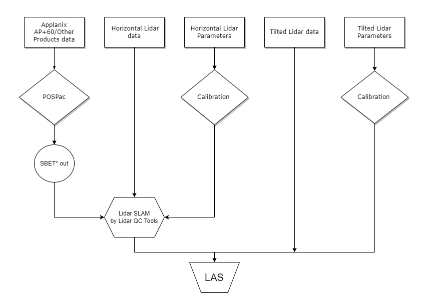
Workflow of Lidar QC Tools.
Jarvis said, “Trimble Applanix has long offered our POSPac Photogrammetry tools for optimizing the application of direct georeferencing with cameras. With the new LiDAR QC Tools, we are doing the same for lidar applications.”
When a camera is installed with lidar, the lidar itself can be used as an aiding sensor to improve position accuracy of the GNSS-inertial trajectory. The LiDAR QC Tools rely on lidar SLAM (simultaneous localization and mapping) technology to create voxels or 3D pixels from the lidar data and match the overlap regions. The software then automatically runs an iterative least squares adjustment using the matched points to solve for the constant lidar boresight angles. It can also make corrections to position and orientation of the trajectory that is used to generate the points. For accurate multi-sensor integration, the boresight angles between the sensors must be known to the highest accuracy. The LiDAR QC boresight calibration tool solves this requirement for mobile mapping using lidar.
“LiDAR QC Tools is used to adjust the trajectory using the point cloud to correct any residual errors, after which it is used to generate a corrected exterior orientation to georeference any onboard camera or other sensor,” Jarvis explained. “It makes direct range measurements to the structures around the vehicle, providing relative position changes of the vehicle. Those measurements can be used to correct the drift in the trajectory.”
LiDAR QC Tools is an essential piece of NavInfo’s underground parking garage project.

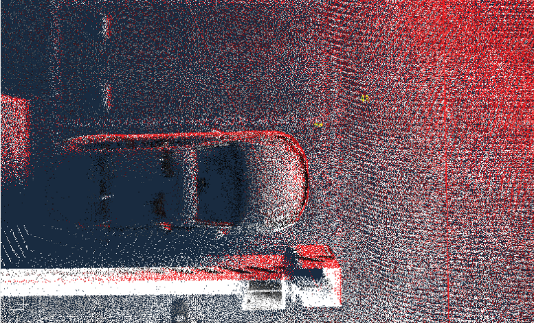
Comparison of results: Before Lidar QC Tools are applied, accuracy was 150 cm (above); after Lidar QC Tools, accuracy improved to 9 cm (below).
Wu Jiahua, process development engineer for research and development at NavInfo, explained, “We use LiDAR QC Tools to perform boresight calibration between IMU and lidar sensor, trajectory adjustment and point-cloud generation in the LAS file format. Using the LiDAR QC Tools greatly improved the accuracy of the HD map in this super-large underground environment.”
He continued, “The functionality of the LiDAR QC Tools has reduced our labor cost while increasing operational efficiency. Not only can it complete the automatic calibration of the lidar, but it can also perform trajectory improvement under GNSS-challenged environments.”
The underground parking garage project started June 2022 and finished in December, with continuous optimization on the data-processing workflow ongoing.
Subscription evolution
Applanix IN-Fusion+™ and LiDAR QC Tools are just two of the Trimble Applanix advances that have come onto the market in the past year.
Very recently, the company launched a brand new as-a-service product called the Trimble PX-1 RTX™ solution, which provides accurate and robust positioning and heading for commercial drone delivery applications.
Joe Hutton, director of inertial technology, land and airborne products, said, “We are excited about the commercial drone delivery market and think our high-accuracy RTX positioning and heading technology can be of great benefit to solving some of the problems that are limiting efficient operations.”
Trimble PX-1 RTX leverages Trimble’s CenterPoint® RTX corrections in a small, high-performance GNSS-inertial piece of hardware to provide real-time, centimeter-level positioning and highly accurate inertial derived true heading measurements.
Trimble PX-1 RTX has several unique features. It’s ideal for accurate guidance and control in magnetically challenged environments thanks to its precise single antenna IMU heading. With Trimble CenterPoint RTX corrections over satellite L-Band or NTRIP, there’s no need for base stations. Further, the Applanix IN-Fusion+ multi-sensor aided inertial technology ensures consistent solution performance in all environments.
Hutton added, “This solution allows operators precise control of the drones during takeoff and landing in order to tackle more demanding operations in tight or partially obstructed spaces. It also minimizes operational risks from poor sensor performance or magnetic interference by ensuring greater positioning redundancy, especially important as commercial drone delivery operations venture into increasingly difficult, or challenging high-stakes environments in urban and suburban environments.”
Post-processing progressions
One of the most significant developments is the introduction of POSPac 9, Applanix’s next generation of post-processing software, which incorporates the Trimble ProPoint, IN-Fusion+ and the latest post-processed CenterPoint RTX technology (PP-RTX 2).
The new POSPac supports all the latest GNSS satellites, signals and frequency bands, and uses advanced multipath and outlier filtering to optimally fuse GNSS data into a robust and accurate aided-inertial position and orientation solution. Real-world results from more than 72 hours of dense urban-area data show that the new POSPac can achieve more than 100% position accuracy improvement versus POSPac 8 for mobile mapping applications. For UAV mapping applications, the PP-RTX 2 service with full BDS III support now achieves convergence to centimeter-level accuracy for short UAV trajectories virtually anywhere in the world.
POSPac Cloud is a cloud-based version of the Applanix POSPac software. The interface to the cloud service is via API, where data collection from Applanix hardware is processed through the internet. The software-as-a-service is available as a flexible pay-per-use model—and cybersecurity is top-of-mind.
Jarvis continued, “With 24/7 monitoring, cybercrime protection, and vulnerability checks, Applanix POSPac Cloud is designed with enhanced security so our users can work confidently.”
Other Trimble Applanix partners have relied on land-based applications and have adopted the Applanix POS LV solution, a compact, fully integrated, turnkey position and orientation system, that also relies on integrated inertial technology to generate stable, reliable and repeatable positioning solutions.
The Fraunhofer-Gesellschaft, the world’s leading applied research organization, is one such organization. The organization’s Institute for Physical Measurement Techniques (IPM) is focused on developing and delivering optical measurement systems for different applications, including detailed mobile mapping solutions. Fraunhofer IPM is working with the leading European telecommunications company, Deutsche Telekom, to create precise maps of urban streets with detailed surface information to optimize the planning for new fiber-optic cables. To achieve this goal, Fraunhofer IPM custom built a measuring system utilizing four cameras and a lidar system. Enhanced location sensing was achieved using Trimble’s Applanix POS LV to provide accurate georeferencing for road geometry, pavement inspection, GIS database and asset management, road surveying, and vehicle dynamics—all to a location accuracy of 1 cm.
In New Zealand, Data Collection Ltd (DCL) is using the Applanix POS LVX in its Road Measurement Data Acquisition System (ROMDAS®). ROMDAS equipment is frequently used to inspect airport runways and tarmacs for foreign object detection (FOD). The ROMDAS LFOD (Laser Foreign Object Detection) has improved airport tarmac surveying. These inspections can be performed with three people in a vehicle in less than two hours.
German-based Railergy, a transportation and solutions company, partnered with an international transport and logistics company to develop autonomous shunting (switching), a technique that will allow a locomotive to move cars into the positions without a driver or remote control. A key component for successful autonomous shunting is the Applanix POS LV direct georeferencing solutions. This solution eliminates the need for ground control points and speeds up mapping activities. With POS LV, Railergy can create an accurate map of the rail yard in an automated, quick and efficient manner and accurately track the live operation in real-time. Railergy is on schedule to deliver the first autonomous locomotive in 2024.
Hutton concluded, “Our focus is and remains upon providing the best possible georeferencing solutions for our customers so they can deliver the best possible mapping and positioning solutions to their customers. We listen to their needs and are continuously investing and adapting our technology and products to ensure they remain competitive. We view our customers as partners and our products are made to be part of their solutions.”
 Vicki Speed has been a freelance writer specializing in the AEC space for over 25 years. She has an interest in and passion for all things about the industry from contracts and risk management to people, processes, equipment and, especially, technology.