The Florida Region of the American Society for Photogrammetry and Remote Sensing (FL-ASPRS) and the University of Florida (UF) Geomatics Division continued their biannual lidar workshops on 8 June 2023. The workshops continue to meet, in-person and virtually, at the Mid-Florida Research & Education Center of the University of Florida’s Institute of Food and Agricultural Sciences and over Zoom. The workshops are open free-of-charge to all interested persons. The Spring 2023 Workshop hosted 68 participants on-site and 78 virtual, the latter from California, Minnesota, Canada, the West Indies and India as well as Florida. With respect to the ASPRS mission statement, “to promote a balanced representation of the interests of government, academia and private enterprise”, the program includes presentation sessions devoted to each of these three sectors.
The business meeting
The workshops provide an opportunity to conduct a biannual region meeting for the members, as well as an educational and social function for the community. At this meeting, the region introduced one newly elected Director, Eric Householder, and thanked Fredrick Hartless for his service to the Board as he cycled off it. Fred was presented with an inscribed Survey Monument commemorating his time on the Board. The retirements of two past, long-serving directors, Brenda Burroughs and Dr. Bon Dewitt, were also announced. Both will be missed.
On an upbeat “retirement” note, the region announced the sunsetting of its old logo (Figure 1A), now over 15 years old, and revealed the updated one (Figure 1B).
Figure 1: Retired region logo (A) on the left and newly adopted region logo (B) on the right.
The region will also be updating banners and other promotional materials with the new logo.
Session 1: State and Federal Updates
The workshops begin with 10-minute briefings from state and federal agencies focused on Florida-based projects. In this workshop, Suwannee River (SRWMD) and Southwest Florida (SWFWMD) Water Management Districts, the Florida Department of Environmental Protection (FDEP) and the Florida Coastal Mapping Program (FCMaP) represented the state agencies, while the US Geological Survey (USGS) and the National Oceanic and Atmospheric Administration (NOAA) presented updates on national projects in the state.
SRWMD: Joe Aufmuth, GIS Librarian—George A. Smathers Libraries at the University of Florida, started the update with a public-private project to georeference historical aerial imagery. Joe discussed the historical image holdings, the workflow by which the images were scanned, and means to access the collection (Figure 2). Joe handed the presentation over to Chad Lopez (Dewberry), to discuss the “private” side of the partnership.
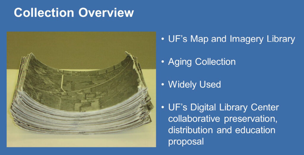
Figure 2: An overview of the historical images at the University of Florida Smathers Libraries.
Chad discussed the SRWMD contract with Dewberry to assemble county-wide photo-mosaics of the historical images to help the SRWMD engineers understand historical water flow prior to the intensive agriculture of the mid-20th century. The project initially involved Bradford and Union Counties, but subsequently included Levy County. Individual scanned frames were georeferenced, their collars removed, then color balanced into a single, seamless mosaic, before being tiled to the Florida Division of Revenue Aerial Index. Chad finished by highlighting some of the challenges (Figure 3).
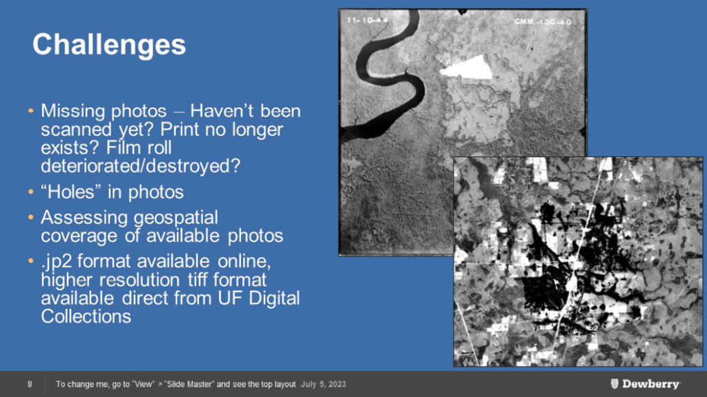
Figure 3: Challenges to constructing seamless historical mosaic images.
SWFWMD: Nicole Hewitt confirmed that all the lidar data from the USGS (2018) Peninsula Project and the SWFWMD enhancements had been published. She finished with a compelling argument, citing FEMA flood protection, habitat destruction via controlled and uncontrolled burning, natural disasters from hurricanes and tropical storms, for the multiple uses of recently collected lidar data and suggested that data be collected at intervals of no longer than six years, coinciding with the Florida County Digital Orthoimagery Program.
FDEP/Florida Seafloor Mapping Initiative (FDEP/FSMI): Alex Reed (FDEP Office of Resilience and Coastal Protection) provided an update on FSMI and introduced its web page on the Florida Geographic Information Office (GIO) hub site at: https://www.floridagio.gov/pages/fsmi (Figure 4). Alex discussed the funding sources and the scope of the project. She indicated that the first round of project assignments in the near shore (0-20 m water depth) have been issued and will focus on topobathymetric lidar.
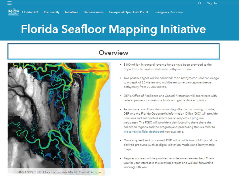
Figure 4: The Florida Seafloor Mapping Initiative (https://www.floridagio.gov/pages/fsmi) public-facing website.
The second round will focus on acoustic technologies for deeper waters and “filling in the voids” in the lidar. She also indicated that the GIO will be hosting a data-collection status dashboard and later providing the resulting digital elevation models as public GIS image services from the State Geospatial Open Data Portal. FSMI is coordinating with the USGS Coastal National Elevation Database staff to create a seamless DEM for Florida’s coast that will be shared publicly at the project’s conclusion.
FCMaP: Dr. Cheryl Hapke (University of South Florida College of Marine Science) described FcMap’s role: it has evolved into a coordinating body of federal, state, and local agencies along with institutions to facilitate the collection and dissemination of coastal seafloor data. Since the original 2019 prioritization study, FCMaP has conducted an updated inventory of seafloor data in 2021 (Figure 5) and is deploying a similar prioritization study of the offshore (20-200 m water depth) areas in 2024.
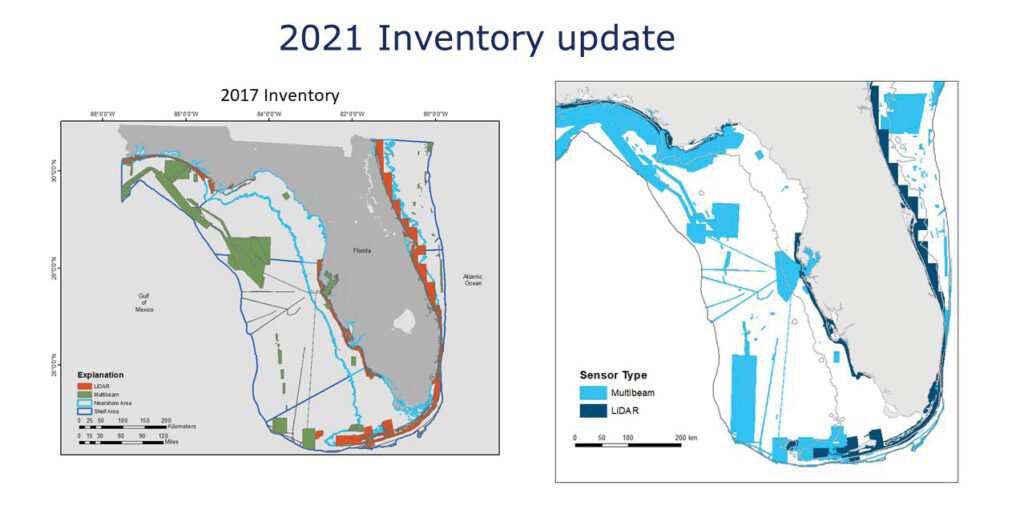
Figure 5: FCMaP update to the available seafloor data for Florida.
USGS: Alexandra “Xan” Fredericks (USGS National Map Liaison) presented a variety of National Geospatial Program initiatives. She started with the current status of 3D Elevation Program (3DEP) lidar in Florida, sharing links to access and view the available data via The National Map and the 3DEP Lidar Explorer (Figure 6). Xan went on to discuss the 3D National Topography Model (3DNTM) and how Florida 3DEP data support this larger vision of integrating national elevation and hydrography datasets into a 3D model.
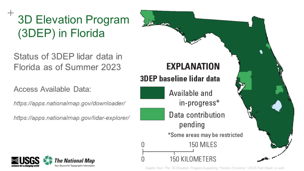
Figure 6: How to access 3DEP data through The National Map.
Finally, workshop participants were invited to become a member of the new ASPRS Lidar Bathymetry Working Group and attendees from outside Florida were encouraged to identify their USGS National Map Liaisons by visiting https://usgs.gov/TNMLiaisons.
NOAA: Stephen White (NOAA Remote Sensing Division) provided the update on NOAA shoreline, imagery and nearshore bathymetry projects in Florida. He began by discussing NOAA’s mission and the Remote Sensing Division’s role therein. He went on to describe the support of hydrographic surveys (lidar and multibeam sonar) and shoreline extraction from lidar and imagery. He provided updates on the progress of FL2201, the Indian River Lagoon topobathymetric lidar project, and the Bipartisan Infrastructure Law (BIL). He highlighted collaborations between NOAA and the Natural Resources Conservation Service, touched on “uncertainty” (total propagated uncertainty: TPU) in topobathymetric data, and concluded with an acknowledgement of Integrated Ocean and Coastal Mapping (IOCM; Figure 7).
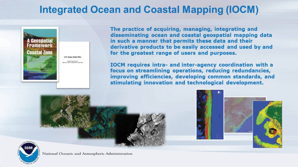
Figure 7: IOCM stressing increased intra- and interagency coordination.
Session 2: The Keynote Speaker
Dave Stein, from NOAA’s Office for Coastal Management in St. Petersburg, Florida was the keynote speaker. Dave works in the Science and Geospatial Division, focusing on ocean mapping, GIS, and remote sensing technology, benthic habitat mapping and the application of geospatial technology to coastal zone management.
He opened with a discussion of the NOAA Digital Coast. Directing users to the website, he highlighted the data, noted the collaborations, and emphasized that the website contains a host of information, not just data (Figure 8).
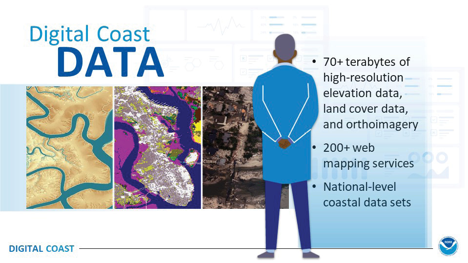
Figure 8: The NOAA Digital Coast overview of contents.
He continued with the various datasets and tools available on the Digital Coast, such as: the Coastal Land Cover (Coastal Change Analysis Program: C-CAP) and the products available. Of special interest to the audience was the impervious surface mapping for Florida derived from 2021 high-resolution imagery, the Sea Level Rise Viewer, the Coastal Flood Exposure Mapper, and the OceanReports generator—“it’s like the Zillow of the ocean”.
He concluded his talk with a discussion of contracting with the Office of Coastal Management. He indicated several of the NOAA/OCM federal, state and local partners, and several of the Sample Projects from FY2022 (Figure 9).
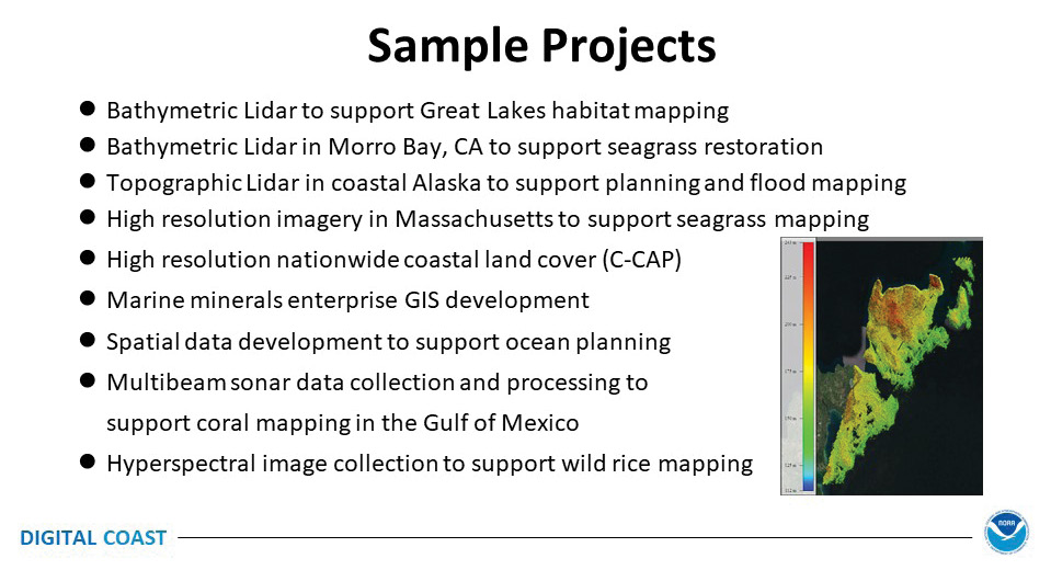
Figure 9: Sample of NOAA/Office of Coastal Management FY2022 projects.
Session 3: Roundtable Discussion
Representatives of the platinum-level sponsors were invited to present brief descriptions of their respective firms prior to a roundtable discussion: Amar Nayegandhi—Dewberry, My-Linh Truong—RIEGL, Tom Ruschkewicz—McKim & Creed, and Jamie Young—Pointerra (Figure 10).
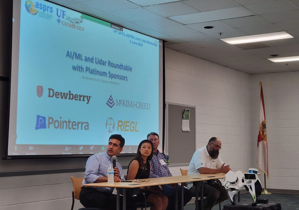
Figure 10: Roundtable participants: from left to right Amar Nayegandhi, My-Linh Truong, Tom Ruschkewicz, and Jamie Young.
Dr. Stephen Medeiros from Embry-Riddle Aeronautical University served as moderator of the session. The topic was the recent emergence of ChatGPT (and other generative AI technologies (ex. DALL-E and Stable Diffusion) and whether there are any opportunities or challenges presented to the industry by AI.
The consensus of the group suggested that these technologies, like several that came before, will be incorporated into the lidar industry as they mature. It is too early to tell how rapidly that will occur, but all were optimistic that there are opportunities.
Session 4: Gold-Level Sponsors
The gold-level sponsors had brief time-slots to introduce their firms and the innovations they offer. Returning gold sponsors, GPI Spatial, Kucera International, Pickett and Associates, and Woolpert were thanked for their ongoing participation in the workshops, while new sponsors Frontier Precision—Unmanned and 3DEO were welcomed to the workshop.
Frontier Precision—Unmanned: Joey Civello discussed his firm’s multiple unmanned portfolio. Of particular interest to the workshop were UAVs in compliance with the National Defense Authorization Act (NDAA) (Figure 11 shows an example).
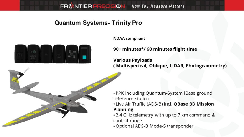
Figure 11: A Frontier Precision NDAA-compliant UAV.
GPI Spatial: Mike Zoltek and Jamey Gray provided a demonstration of the capabilities of their NavVis system (Figure 12) by scanning the workshop space and uploading the data to the cloud for automated processing beforehand, and presenting the results in the session. Additionally, they allowed all interested parties to wear the scanner while providing an overview of the system controls and capabilities.
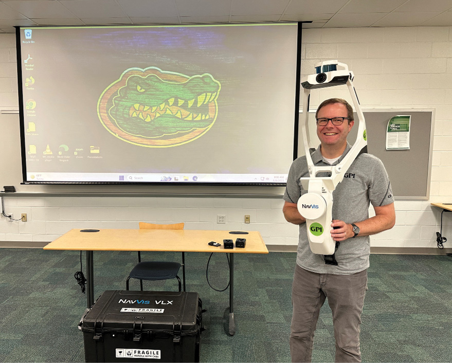
Figure 12: Jamey Gray, from GPI, demonstrating the NavVis wearable mobile lidar scanner.
Kucera International: Barbora Ubar represented Kucera International. She welcomed everyone to the workshop and yielded her time to Pickett and Associates.
Pickett and Associates: Craig Emrick highlighted the multiple survey services Pickett and Associates offer and highlighted a UAV project in south Florida (Figure 13).
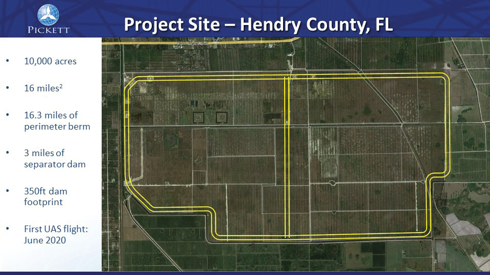
Figure 13: Pickett and Associates UAV imaging project in south Florida.
3DEO: Dr.Kimberly Reichel-Vischi represented 3DEO, Inc. She re-introduced attendees to Geiger-mode lidar technology and highlighted some of the advantages of the 3DEO Zion system. She also demonstrated the 3DEO workflow for Geiger-mode processing (Figure 14).
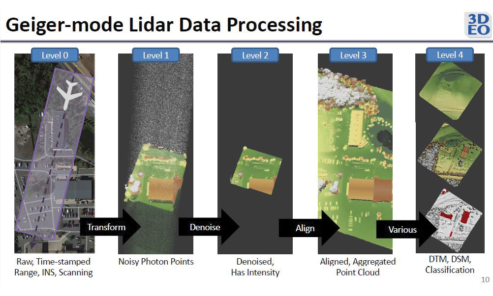
Figure 14: 3DEO workflow for Geiger-mode lidar data processing.
Woolpert: Geospatial program director Rick Householder represented Woolpert and discussed the firm’s long history, starting with photogrammetry, along with current capabilities in the lidar, GIS and remote sensing arenas. He also described Woolpert’s numerous aerial, marine and sensor assets and concluded by introducing some of the more innovative capabilities including 3D imagery and viewers, as well as cloud-based solutions.
Session 5: Academic Presentations
In accordance with the tradition at the UF/FL-ASPRS Workshops, student presenters are rewarded with an autographed copy of the ASPRS DEM manual1 presented by one of the authors, Amar Nayegandhi (Figure 15). For this workshop, students from the University of Florida, the University of South Florida, Florida Atlantic University, and the University of Central Florida presented their remote sensing research.
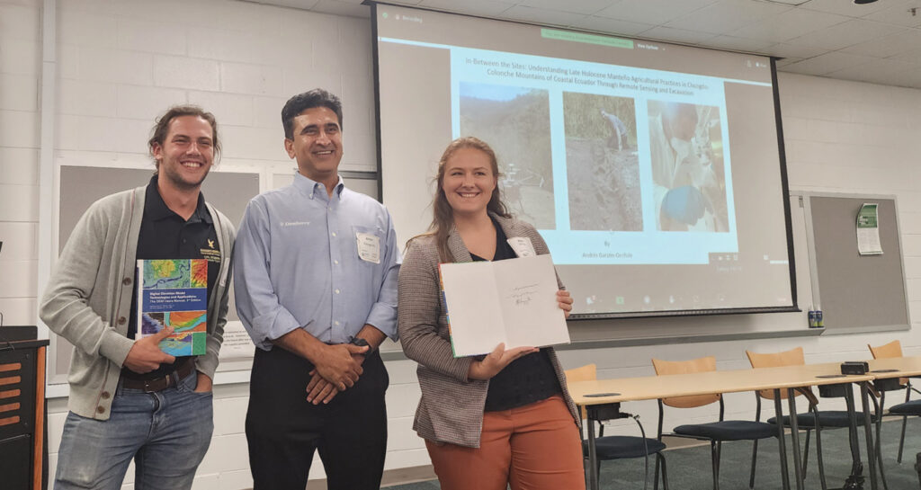
Figure 15: From left to right, Michael Espriella (University of Florida) and Kylie Dillinger (University of South Florida) receiving autographed copies of the DEM Users Manual, 3rd Edition from Amar Nayegandhi (Dewberry).
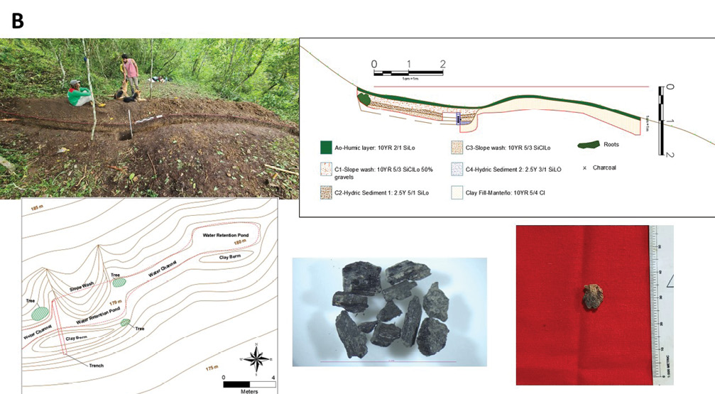
Florida Atlantic University: Andrés Garzón-Oechsle presented his research, “In-between the sites: understanding late Holocene Manteño agricultural practices in Chongón-Colonche Mountains of Coastal Ecuador through remote sensing and excavation”, on leveraging the interface between traditional archaeology, remote sensing and climate change science to understand how South American cultures of the Pacific coast responded to changing conditions from El Niño-Southern Oscillation (ENSO) and how those resiliency approaches can be used in today’s changing climate.
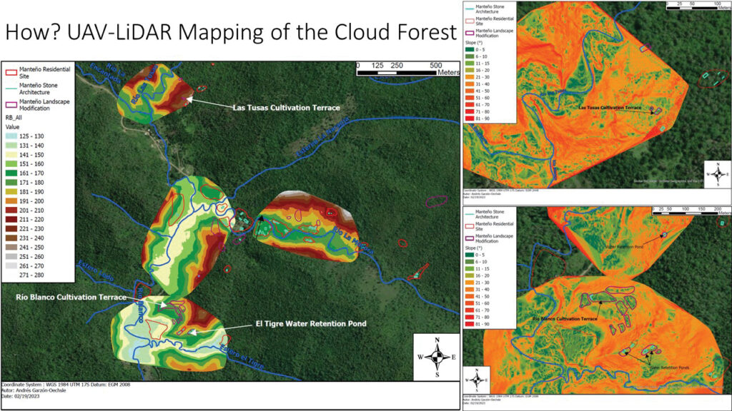
Figure 16: UAV-lidar digital elevation models showing connections between inhabited areas in the cloud forest of Ecuador.
Andrés used UAV-lidar mapping in the cloud forest of coastal Ecuador, his research study area, to reveal a modified landscape of cultivation terraces, water retention ponds, and water distribution channels (Figure 16). Using the combination of archaeology and remote sensing, he pieced together how the Manteño endured extreme droughts and torrential rains during the Medieval Climate Anomaly and the Little Ice Age from changing conditions in ENSO by creating a modified human landscape in the most resilient region of their territory, the cloud forest (Figures 17A and 17B).
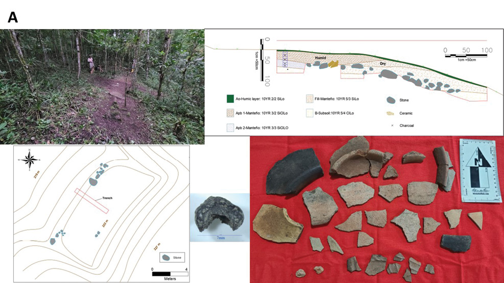
Figure 17: (above) Ground-level and profile views and artifacts associated with cultivation terraces and (below) retention ponds in the cloud forest of Ecuador.
University of Central Florida: Syed Zohaib Hassan presented his research, “UAV-based monitoring applications for solid waste facilities,” along with co-author Dr. Patrick Sun. As municipal landfills are particularly vulnerable to hurricanes and other climate events, Syed’s research considers the use of UAV technology to monitor municipal solid waste landfills. Unlike most presentations at the workshop, Syed’s solution incorporated remote sensing for topography (lidar scanning), air quality (gases), RGB imaging and multi-spectral sensing (Figure 18).
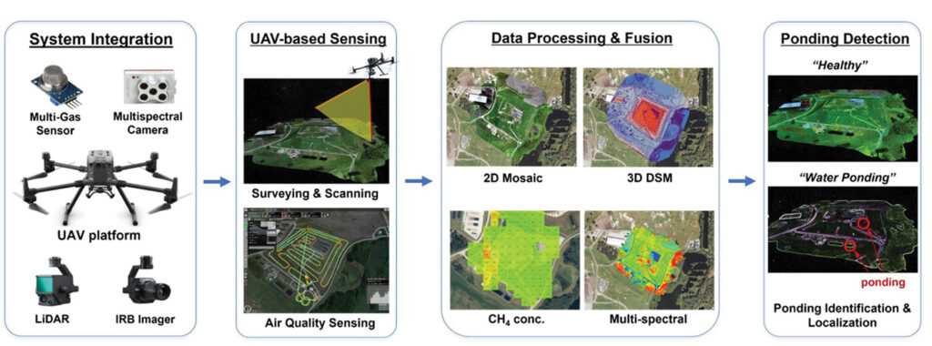
Figure 18: Proposed UAV-based data fusion technique to monitor landfill.
Syed chose a study site, a county landfill, in southeastern Hillsborough County, Florida and collected the remotely sensed data both before and after Hurricane Ian in the late summer of 2022. This study was conducted to analyze the deteriorative effects and damages caused by storm water to landfill’s cover.
The results of the study demonstrated the efficacy of the methodology and did not detect any gas emissions or leakage resulting from the storm (Figure 19). Further statistical analysis will be performed in the future. In addition to the remotely sensed data, air quality data was collected on the landfill to detect any possible landfill-gas (LFG) leakages by performing UAV-based context-aware flights over the landfill’s cover. Results shows that there were no leak hot spots of methane on the landfill.
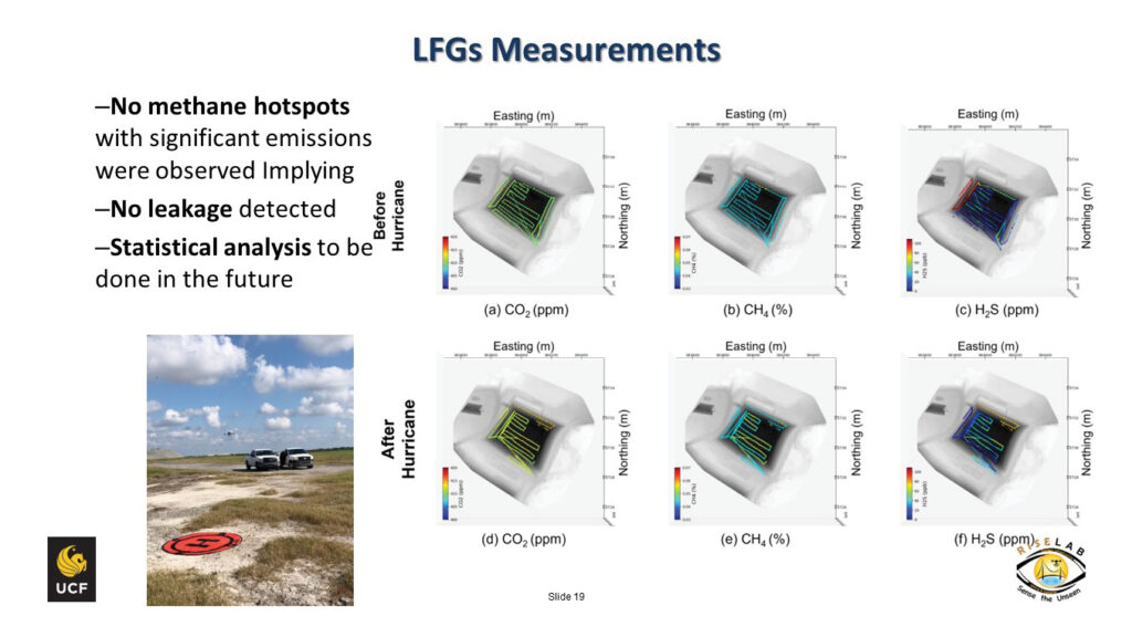
Figure 19: Results of monitoring a municipal landfill in southeastern Hillsborough County before and after Hurricane Ian (late summer, 2022).
University of Florida: Michael Espriella presented “Monitoring intertidal oyster reefs using drone-based lidar” along with co-authors Dr. Vincent Lecours, Dr. Ed Camp, H. Andrew Lassiter, Dr. Ben Wilkinson, Dr. Peter Frederick and Dr. Simon Pittman. The research focused on intertidal habitats in Florida as these areas, particularly in the “Big Bend” area, are experiencing significant change resulting from both environmental pressures and anthropogenic factors.
Michael identified several challenges to using traditional, quadrat sampling methods (Figure 20) to estimate and monitor oyster population size and health. As these methods are extremely labor-intensive and time consuming, aerial sampling and high-resolution imagery from drone-based cameras may prove more efficient.
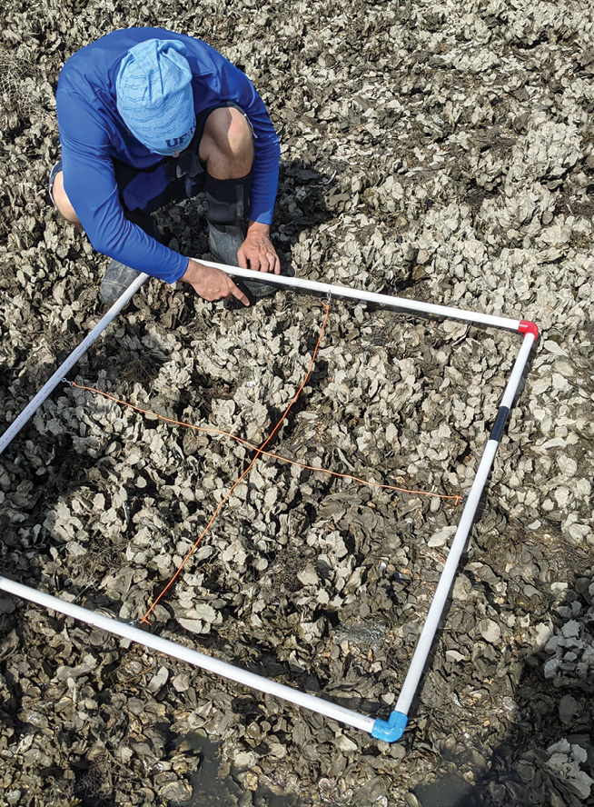
Figure 20: Conventional quadrat sampling for oyster populations.
The team developed a suite of 122 surface complexity metrics from lidar point clouds, of which 46 were found to have a significant relationship with live oyster counts, including skewness of elevation values, volume-to-area ratio, and gray-level co-occurrence matrix features (Figure 21). The team highlighted the utility of metrics that have direct parallels to ecological processes, such as volume-to-area ratio, which can help inform oyster reef shell budget monitoring.
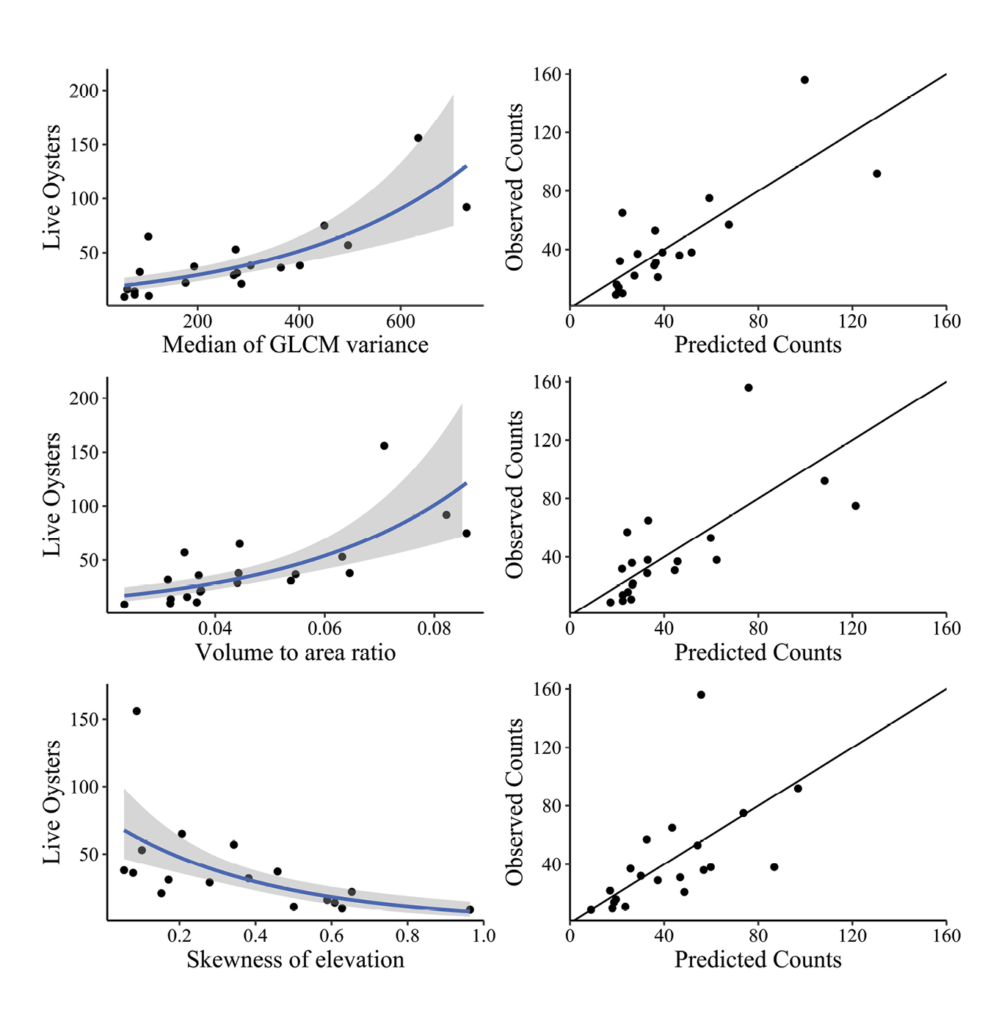
Figure 21: Three significant models representing the relationship between live oyster counts and surface complexity metrics (left). The blue line represents the negative binomial regression line, and the grey area corresponds with the 95% confidence interval. The column on the right shows predicted and observed counts for each respective model, with a one-to-one line for reference.
University of South Florida: Kylie Dillinger presented her research, “Digital preservation of fading memories: virtualization and online dissemination of the WWII-era Japanese America detention camp at Granada (Colorado),” directed towards preserving a digital record of the camp that was dismantled and abandoned in 1945, with the site being designated as a National Park in 2022. The goal of the reconstruction project was to capture the entirety of the 12K Block as it currently exists and reconstruct it digitally to show how it changed over time.
Fieldwork entailed a large number of setups from different perspectives with Faro terrestrial scanners. Once on-site Kylie was immediately faced with some limitations to the research: limited time (one week), a very large area (approximately 1 square mile), and inclement weather.
The project ultimately worked out well and resulted in high-resolution lidar scans of Block 12K (Figure 22), along with scans of a modified branch bench, the 11F Rec Hall, and a display in the Amache Museum.
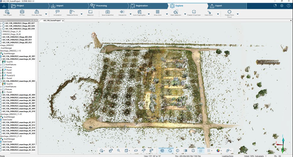
Figure 22: Terrestrial scan of Block 12K, Japanese detention camp, Granada, Colorado.
1 Maune, D.F. and A. Nayegandhi (eds.), 2018. Digital Elevation Model Technologies and Applications: The DEM Users Manual, 3rd Edition, ASPRS, Bethesda, Maryland, 652 pp.